
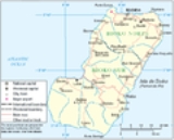
Bioko
Encyclopedia
Cameroon
Cameroon, officially the Republic of Cameroon , is a country in west Central Africa. It is bordered by Nigeria to the west; Chad to the northeast; the Central African Republic to the east; and Equatorial Guinea, Gabon, and the Republic of the Congo to the south. Cameroon's coastline lies on the...
, in the Gulf of Guinea
Gulf of Guinea
The Gulf of Guinea is the northeasternmost part of the tropical Atlantic Ocean between Cape Lopez in Gabon, north and west to Cape Palmas in Liberia. The intersection of the Equator and Prime Meridian is in the gulf....
. It is the northernmost part of Equatorial Guinea
Equatorial Guinea
Equatorial Guinea, officially the Republic of Equatorial Guinea where the capital Malabo is situated.Annobón is the southernmost island of Equatorial Guinea and is situated just south of the equator. Bioko island is the northernmost point of Equatorial Guinea. Between the two islands and to the...
with a population of 124,000 and an area of 2017 km² (779 sq mi). It is volcanic with its highest peak the Pico Basile
Pico Basilé
Pico Basilé is the highest mountain on the island of Bioko, which is part of Equatorial Guinea. With an altitude of 9,878 ft , it is the summit of the largest and highest of three overlapping basaltic shield volcanoes which form the island. From the summit, Mt. Cameroon can be seen to the...
at 3012 m (9,882 ft).
Geography
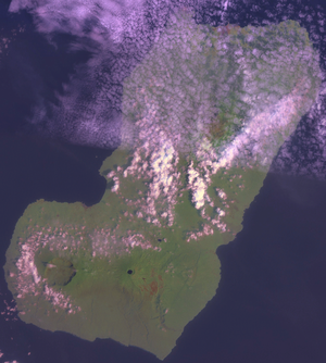
Bioko has a total area of 2017 km² (779 sq mi). It is 70 km long from NNE to SSW and about 32 km across. It is volcanic and very mountainous with the highest peak Pico BasilePico Basilé
Pico Basilé is the highest mountain on the island of Bioko, which is part of Equatorial Guinea. With an altitude of 9,878 ft , it is the summit of the largest and highest of three overlapping basaltic shield volcanoes which form the island. From the summit, Mt. Cameroon can be seen to the...
(3012 m (9,882 ft)). It thus resembles neighbouring islands São Tomé
São Tomé Island
São Tomé Island, at , is the largest island of São Tomé and Príncipe and is home in 2009 to about 157,000 or 96% of the nation's population. This island and smaller nearby islets make up São Tomé Province, which is divided into six districts. The main island is located 2 km north of the...
and Príncipe
Príncipe
Príncipe is the northern and smaller of the two major islands of the country of São Tomé and Príncipe lying off the west coast of Africa. It has an area of 136 km² and a population of approximately 5,000. The island is a heavily eroded volcano over three million years old, surrounded by other...
. Like them it lies on the Cameroon Line
Cameroon line
The Cameroon line is a chain of volcanoes.It includes islands in the Gulf of Guinea and mountains that extend along the border region of eastern Nigeria and western Cameroon, from Mount Cameroon on the Gulf of Guinea north and east towards Lake Chad....
.
Bioko used to be the end of a peninsula attached to the mainland in what is now Cameroon, but it was cut off when sea levels rose 10,000 years ago at the end of the last ice age
Ice age
An ice age or, more precisely, glacial age, is a generic geological period of long-term reduction in the temperature of the Earth's surface and atmosphere, resulting in the presence or expansion of continental ice sheets, polar ice sheets and alpine glaciers...
.
Demographics
The island has a population of 124,000 inhabitants, most of whom belong to the Bubi people. The rest of the population are Fernandinos, Spaniards and immigrants from Río MuniRío Muni
Río Muni is the Continental Region of Equatorial Guinea, and comprises the mainland geographical region, covering 26,017 km².-History:Río Muni was ceded by Portugal to Spain in 1778 in the Treaty of El Pardo...
, Nigeria
Nigeria
Nigeria , officially the Federal Republic of Nigeria, is a federal constitutional republic comprising 36 states and its Federal Capital Territory, Abuja. The country is located in West Africa and shares land borders with the Republic of Benin in the west, Chad and Cameroon in the east, and Niger in...
and Cameroon
Cameroon
Cameroon, officially the Republic of Cameroon , is a country in west Central Africa. It is bordered by Nigeria to the west; Chad to the northeast; the Central African Republic to the east; and Equatorial Guinea, Gabon, and the Republic of the Congo to the south. Cameroon's coastline lies on the...
.
Etymology
Bioko's native name is Otcho from the Bube language.The Portuguese
Portugal
Portugal , officially the Portuguese Republic is a country situated in southwestern Europe on the Iberian Peninsula. Portugal is the westernmost country of Europe, and is bordered by the Atlantic Ocean to the West and South and by Spain to the North and East. The Atlantic archipelagos of the...
navigator Fernão do Pó
Fernão do Pó
Fernão do Pó , also Fernão Pó, Fernando Pó, Fernando Poo was a Portuguese navigator and explorer of the West African coast. He discovered the islands in the Gulf of Guinea around 1472, one of which until the mid 1900s bore a version of his name, Fernando Pó or Fernando Poo. The island is...
in 1472 named it Formosa Flora ('Beautiful Flower'), but in 1494 it was renamed after its discoverer Fernando Pó.
History
The island was inhabited in the middle of the first millennium BC by Bantu tribes from the mainland who formed the Bubi ethnic group. Unlike other islands in the area, Bioko had an indigenous African population. Still a distinct ethnic group on the island today, these indigenous people, the Bubi, speak a BantuBantu languages
The Bantu languages constitute a traditional sub-branch of the Niger–Congo languages. There are about 250 Bantu languages by the criterion of mutual intelligibility, though the distinction between language and dialect is often unclear, and Ethnologue counts 535 languages...
language. The island was probably inhabited by this or other Bantu-speaking groups since before the 7th century BC
7th century BC
The 7th century BC started the first day of 700 BC and ended the last day of 601 BC.The Assyrian Empire continued to dominate the Near East during this century, exercising formidable power over neighbors like Babylon and Egypt. In the last two decades of the century, however, the empire began to...
.
In 1472, the Portuguese
Portugal
Portugal , officially the Portuguese Republic is a country situated in southwestern Europe on the Iberian Peninsula. Portugal is the westernmost country of Europe, and is bordered by the Atlantic Ocean to the West and South and by Spain to the North and East. The Atlantic archipelagos of the...
navigator Fernão do Pó
Fernão do Pó
Fernão do Pó , also Fernão Pó, Fernando Pó, Fernando Poo was a Portuguese navigator and explorer of the West African coast. He discovered the islands in the Gulf of Guinea around 1472, one of which until the mid 1900s bore a version of his name, Fernando Pó or Fernando Poo. The island is...
was the first European to visit the island. He named it Formosa Flora ('Beautiful Flower'), but in 1494 it was renamed after its discoverer (Fernando Pó). The Portuguese developed the island for sugarcane crops, and while considered poor quality, the refineries' output was such that Fernando Po sugar briefly dominated the trade centres in Europe.
In 1642, the Dutch East India Company
Dutch East India Company
The Dutch East India Company was a chartered company established in 1602, when the States-General of the Netherlands granted it a 21-year monopoly to carry out colonial activities in Asia...
established trade bases on the island without Portuguese consent, temporarily centralizing from there its slave trade in the Gulf of Guinea. The Portuguese appeared again on the island in 1648, replacing the Dutch Company with one of their own, also dedicated to slave trading and established in its neighbour island Corisco
Corisco
Corisco, or Mandj, is a small island of Equatorial Guinea, located 29 km southwest of the Rio Muni estuary that defines the border with Gabon...
.
Parallel with this establishment, the Bubi clans began the slow process of establishing the core of a new kingdom on the island, especially after the activity of some local chiefs such as Molambo (approx. 1700–1760). During a period when enslavement was increasing in the region, local clans abandoned their coastal settlements and settled in the safer hinterland.
Treaty of El Pardo (1778)
The Treaty of El Pardo was signed on March 11, 1778 between Queen Maria I of Portugal and King Charles III of Spain. The treaty aimed at resolving long-standing territorial disputes arising from non-observance of the terms of the Treaty of Tordesillas and subsequent treaties to resolve the matter...
in 1778, Portugal ceded to Spain Fernando Po, Annobón
Annobón
Annobón may refer to:* Annobón Province* Annobonese language* Annobon people...
and the Guinea
Guinea
Guinea , officially the Republic of Guinea , is a country in West Africa. Formerly known as French Guinea , it is today sometimes called Guinea-Conakry to distinguish it from its neighbour Guinea-Bissau. Guinea is divided into eight administrative regions and subdivided into thirty-three prefectures...
coast, Rio Muni
Río Muni
Río Muni is the Continental Region of Equatorial Guinea, and comprises the mainland geographical region, covering 26,017 km².-History:Río Muni was ceded by Portugal to Spain in 1778 in the Treaty of El Pardo...
, together forming modern Equatorial Guinea
Equatorial Guinea
Equatorial Guinea, officially the Republic of Equatorial Guinea where the capital Malabo is situated.Annobón is the southernmost island of Equatorial Guinea and is situated just south of the equator. Bioko island is the northernmost point of Equatorial Guinea. Between the two islands and to the...
. The treaty was signed by Queen Mary I of Portugal and King Charles III of Spain
Charles III of Spain
Charles III was the King of Spain and the Spanish Indies from 1759 to 1788. He was the eldest son of Philip V of Spain and his second wife, the Princess Elisabeth Farnese...
, in exchange for territory on the American continent. Spain then mounted an expedition to Fernando Po, led by the Conde de Argelejos, who stayed for four months. In October 1778, Spain installed a governor on the island who stayed until 1780, when the Spanish mission left the island.
Chief Molambo was succeeded by another local leader, Lorite (1760–1810), who was succeeded by Lopoa (1810–1842). After abolishing their slave trade, from 1827 to 1843 the British leased bases at Port Clarence (modern Malabo
Malabo
Malabo is the capital of Equatorial Guinea, located on the northern coast of Bioko Island on the rim of a sunken volcano....
) and San Carlos for their anti-slavery
Slavery
Slavery is a system under which people are treated as property to be bought and sold, and are forced to work. Slaves can be held against their will from the time of their capture, purchase or birth, and deprived of the right to leave, to refuse to work, or to demand compensation...
patrols. The settlement at Port Clarence (named after the Duke of Clarence
William IV of the United Kingdom
William IV was King of the United Kingdom of Great Britain and Ireland and of Hanover from 26 June 1830 until his death...
) was constructed under the supervision of William Fitzwilliam Owen
William Fitzwilliam Owen
Vice Admiral William Fitzwilliam Owen , was a British naval officer and explorer. He is best known for his exploration of the west and east African coasts, discovery of the Seaflower Channel off the coast of Sumatra and for surveying the Canadian Great Lakes...
, who had previously mapped most of the coasts of Africa and was a zealous anti-slaver. During his three year command, his forces detained 20 ships and liberated 2,500 slaves. The Court of Mixed Commission was moved from Freetown
Freetown
Freetown is the capital and largest city of Sierra Leone, a country in West Africa. It is a major port city on the Atlantic Ocean located in the Western Area of the country, and had a city proper population of 772,873 at the 2004 census. The city is the economic, financial, and cultural center of...
to Clarence to hasten the legal process.
In March 1843, Juan José Lerena planted the Spanish flag in Malabo
Malabo
Malabo is the capital of Equatorial Guinea, located on the northern coast of Bioko Island on the rim of a sunken volcano....
, starting the decline of British influence on the island. The British lease was finally revoked in 1855. Madabita (1842–1860) and Sepoko (1860–1875) were principal local chiefs during the reestablishment of Spanish rule on the island. This period was also marked by the immigration of several hundred Afro-Cuban
Afro-Cuban
The term Afro-Cuban refers to Cubans of Sub Saharan African ancestry, and to historical or cultural elements in Cuba thought to emanate from this community...
s as well as tens of Spanish scholars and politicians.
In 1923–30 the League of Nations
League of Nations
The League of Nations was an intergovernmental organization founded as a result of the Paris Peace Conference that ended the First World War. It was the first permanent international organization whose principal mission was to maintain world peace...
investigated the transportation of migrant labour between Liberia
Liberia
Liberia , officially the Republic of Liberia, is a country in West Africa. It is bordered by Sierra Leone on the west, Guinea on the north and Côte d'Ivoire on the east. Liberia's coastline is composed of mostly mangrove forests while the more sparsely populated inland consists of forests that open...
and the Spanish colony of Fernando Po. Although the League concentrated its attention on Liberia, a closer examination revealed labour abuse as the product of conditions on Fernando Po. In the last quarter of the 19th century, black planters on the island had shifted from palm oil
Palm oil
Palm oil, coconut oil and palm kernel oil are edible plant oils derived from the fruits of palm trees. Palm oil is extracted from the pulp of the fruit of the oil palm Elaeis guineensis; palm kernel oil is derived from the kernel of the oil palm and coconut oil is derived from the kernel of the...
trading to cocoa cultivation. Their dependence on migrant labour and increasing competition with Europeans resulted in an economic crisis in the first years of the twentieth century. Planters detained labour but failed to pay contracts, resulting in a situation akin to slavery.
During the Nigerian civil war
Nigerian Civil War
The Nigerian Civil War, also known as the Nigerian-Biafran War, 6 July 1967–15 January 1970, was a political conflict caused by the attempted secession of the southeastern provinces of Nigeria as the self-proclaimed Republic of Biafra...
in the 20th century, relief agencies used the island as a base for flights into Biafra
Biafra
Biafra, officially the Republic of Biafra, was a secessionist state in south-eastern Nigeria that existed from 30 May 1967 to 15 January 1970, taking its name from the Bight of Biafra . The inhabitants were mostly the Igbo people who led the secession due to economic, ethnic, cultural and religious...
.
Today
Malabo
Malabo is the capital of Equatorial Guinea, located on the northern coast of Bioko Island on the rim of a sunken volcano....
is the capital city of Equatorial Guinea
Equatorial Guinea
Equatorial Guinea, officially the Republic of Equatorial Guinea where the capital Malabo is situated.Annobón is the southernmost island of Equatorial Guinea and is situated just south of the equator. Bioko island is the northernmost point of Equatorial Guinea. Between the two islands and to the...
and the largest city on the island. The island is mostly covered by tropical rainforest
Tropical rainforest
A tropical rainforest is an ecosystem type that occurs roughly within the latitudes 28 degrees north or south of the equator . This ecosystem experiences high average temperatures and a significant amount of rainfall...
.
Located on Punta Europa, west of Malabo, the Alba Gas Plant
Natural gas processing
Natural-gas processing is a complex industrial process designed to clean raw natural gas by separating impurities and various non-methane hydrocarbons and fluids to produce what is known as pipeline quality dry natural gas.-Background:...
processes natural gas delivered from offshore production wells. The plant is operated by Marathon Oil
Marathon Oil
Marathon Oil Corporation is a United States-based oil and natural gas exploration and production company. Principal exploration activities are in the United States, Norway, Equatorial Guinea, Angola and Canada. Principal development activities are in the United States, the United Kingdom, Norway,...
Company through its subsidiary, Marathon Equatorial Guinea Production Limited (MEGPL). The plant produces natural gas liquids (NGL) including propane, butane, and condensate products. The majority of the residue gas from the Alba plant is delivered to a natural gas liquefaction plant operated by EG LNG
EG LNG
EG LNG is a LNG company that operates a liquid natural gas terminal and plant in Malabo, Bioko Island, Equatorial Guinea. The LNG plant began operation in 2007 and the first cargo of LNG was delivered on 24 May 2007....
. A portion of the Alba plant residue is also delivered to the Atlantic Methanol Production Company (AMPCO) and is used to produce methanol
Methanol
Methanol, also known as methyl alcohol, wood alcohol, wood naphtha or wood spirits, is a chemical with the formula CH3OH . It is the simplest alcohol, and is a light, volatile, colorless, flammable liquid with a distinctive odor very similar to, but slightly sweeter than, ethanol...
. The products from all three plants are loaded onto ocean going tanker ships for export.
A rectangular transport route links the four main cities Malabo
Malabo
Malabo is the capital of Equatorial Guinea, located on the northern coast of Bioko Island on the rim of a sunken volcano....
, Luba
Luba, Equatorial Guinea
Luba is the second largest town of Bioko in Equatorial Guinea, having a population of around 7,000 people. It lies on the west coast beneath volcanic peaks and is a port for the logging industry...
, Baney
Baney
Baney is a town in Equatorial Guinea. It is located in Bioko Norte Province and has a population of 2365....
and Riaba
Riaba
Riaba is a town in Equatorial Guinea. It is also the 30th largest settlement in the country.-Location and population:It is located in Bioko Sur Province.It has a population of 1,071.-Road communications:...
.
Infrastructure Development
On 4 June 2011, Equatorial Guinean President Teodoro Obiang Nguema MbasogoTeodoro Obiang Nguema Mbasogo
Teodoro Obiang Nguema Mbasogo is an Equatoguinean politician who has been President of Equatorial Guinea since 1979. He ousted his uncle, Francisco Macías Nguema, in an August 1979 military coup and has overseen Equatorial Guinea's emergence as an important oil producer, beginning in the 1990s...
inaugurated several infrastructure development projects on Bioko including a new documentation center on Bioko, the expansion of the passenger terminal at Malabo International Airport
Malabo International Airport
Malabo Airport or Saint Isabel Airport is an airport located at Punta Europa, Bioko Island, Equatorial Guinea. The airport is named after the capital, Malabo, approximately 9 kilometres to the east...
, a Police Camp, the Palace of Conferences, drinking water networks in Riaba, and a road from Riaba
Riaba
Riaba is a town in Equatorial Guinea. It is also the 30th largest settlement in the country.-Location and population:It is located in Bioko Sur Province.It has a population of 1,071.-Road communications:...
to Moka
Moka
Moka is a town in Mauritius. It's also the home to the University of Mauritius, the Mahatma Gandhi Institute and the Mauritius Broadcasting Corporation....
. The projects cost the Equatorial Guinean government 20 billion CFA francs.
External links
- Bioko Biodiversity Protection Program
- Gulf of Guinea Conservation Group
- Virginia Morell: "Island ark", National Geographic MagazineNational Geographic MagazineNational Geographic, formerly the National Geographic Magazine, is the official journal of the National Geographic Society. It published its first issue in 1888, just nine months after the Society itself was founded...
August 2008; link