

Western High Plateau
Encyclopedia
Cameroon
Cameroon, officially the Republic of Cameroon , is a country in west Central Africa. It is bordered by Nigeria to the west; Chad to the northeast; the Central African Republic to the east; and Equatorial Guinea, Gabon, and the Republic of the Congo to the south. Cameroon's coastline lies on the...
characterised by high relief, cool temperatures, heavy rainfall, and savanna
Savanna
A savanna, or savannah, is a grassland ecosystem characterized by the trees being sufficiently small or widely spaced so that the canopy does not close. The open canopy allows sufficient light to reach the ground to support an unbroken herbaceous layer consisting primarily of C4 grasses.Some...
vegetation. The region lies along the Cameroon line
Cameroon line
The Cameroon line is a chain of volcanoes.It includes islands in the Gulf of Guinea and mountains that extend along the border region of eastern Nigeria and western Cameroon, from Mount Cameroon on the Gulf of Guinea north and east towards Lake Chad....
and consists of mountain range
Mountain range
A mountain range is a single, large mass consisting of a succession of mountains or narrowly spaced mountain ridges, with or without peaks, closely related in position, direction, formation, and age; a component part of a mountain system or of a mountain chain...
s and volcano
Volcano
2. Bedrock3. Conduit 4. Base5. Sill6. Dike7. Layers of ash emitted by the volcano8. Flank| 9. Layers of lava emitted by the volcano10. Throat11. Parasitic cone12. Lava flow13. Vent14. Crater15...
es made of crystalline and igneous rock. The region borders the South Cameroon Plateau
South Cameroon Plateau
The South Cameroon Plateau or Southern Cameroon Plateau is the dominant geographical feature of Cameroon. The plateau lies south of the Adamawa Plateau and southeast of the Cameroon Range. It slopes south and west until giving way to the Cameroon coastal plain in the southwest and the Congo River...
to the southeast, the Adamawa Plateau
Adamawa Plateau
The Adamawa Plateau is a plateau region in west-central Africa stretching from south-eastern Nigeria through north-central Cameroon to the Central African Republic. The plateau was named after Fulani Muslim leader Modibo Adama. The part of the plateau that lies in Nigeria is more popularly known...
to the northeast, and the Cameroon coastal plain to the south.
Topography and geology
The Western High Plateau lies along the Cameroon lineCameroon line
The Cameroon line is a chain of volcanoes.It includes islands in the Gulf of Guinea and mountains that extend along the border region of eastern Nigeria and western Cameroon, from Mount Cameroon on the Gulf of Guinea north and east towards Lake Chad....
, a series of volcanic swells running from the Atlantic Ocean
Atlantic Ocean
The Atlantic Ocean is the second-largest of the world's oceanic divisions. With a total area of about , it covers approximately 20% of the Earth's surface and about 26% of its water surface area...
in the southwestern part of the plateau to the Adamawa Plateau
Adamawa Plateau
The Adamawa Plateau is a plateau region in west-central Africa stretching from south-eastern Nigeria through north-central Cameroon to the Central African Republic. The plateau was named after Fulani Muslim leader Modibo Adama. The part of the plateau that lies in Nigeria is more popularly known...
in the northeast. The region is characterised by accidented relief of massif
Massif
In geology, a massif is a section of a planet's crust that is demarcated by faults or flexures. In the movement of the crust, a massif tends to retain its internal structure while being displaced as a whole...
s and mountains. The Western High Plateau features several dormant volcano
Volcano
2. Bedrock3. Conduit 4. Base5. Sill6. Dike7. Layers of ash emitted by the volcano8. Flank| 9. Layers of lava emitted by the volcano10. Throat11. Parasitic cone12. Lava flow13. Vent14. Crater15...
es, including the Bamboutos Mountains, Mount Oku
Mount Oku
Mount Oku, or Kilum Mountain, is the largest volcano in the Oku Massif, in the Cameroon Volcanic Line, located in the Oku region of the Western High Plateau of Cameroon.It is the second highest mountain in mainland West Africa....
, and Mount Kupe.
The plateau rises in steps from the west. To the east, it terminates in mountains that range from 1,000 meters to 2,500 meters in height, terminating in the South Cameroon Plateau
South Cameroon Plateau
The South Cameroon Plateau or Southern Cameroon Plateau is the dominant geographical feature of Cameroon. The plateau lies south of the Adamawa Plateau and southeast of the Cameroon Range. It slopes south and west until giving way to the Cameroon coastal plain in the southwest and the Congo River...
.
The plateau gives way to the Adamawa Plateau
Adamawa Plateau
The Adamawa Plateau is a plateau region in west-central Africa stretching from south-eastern Nigeria through north-central Cameroon to the Central African Republic. The plateau was named after Fulani Muslim leader Modibo Adama. The part of the plateau that lies in Nigeria is more popularly known...
to the northeast, which is a larger but less accidented region.
The core of the plateau is made up of volcanic rock
Volcanic rock
Volcanic rock is a rock formed from magma erupted from a volcano. In other words, it is an igneous rock of volcanic origin...
, which is ringed by plutonic rock.
The base is crystalline and metamorphic rock
Metamorphic rock
Metamorphic rock is the transformation of an existing rock type, the protolith, in a process called metamorphism, which means "change in form". The protolith is subjected to heat and pressure causing profound physical and/or chemical change...
.
The base rock is primarily gneiss
Gneiss
Gneiss is a common and widely distributed type of rock formed by high-grade regional metamorphic processes from pre-existing formations that were originally either igneous or sedimentary rocks.-Etymology:...
and granite
Granite
Granite is a common and widely occurring type of intrusive, felsic, igneous rock. Granite usually has a medium- to coarse-grained texture. Occasionally some individual crystals are larger than the groundmass, in which case the texture is known as porphyritic. A granitic rock with a porphyritic...
that dates to the Precambrian period
Precambrian
The Precambrian is the name which describes the large span of time in Earth's history before the current Phanerozoic Eon, and is a Supereon divided into several eons of the geologic time scale...
. A layer of basalt
Basalt
Basalt is a common extrusive volcanic rock. It is usually grey to black and fine-grained due to rapid cooling of lava at the surface of a planet. It may be porphyritic containing larger crystals in a fine matrix, or vesicular, or frothy scoria. Unweathered basalt is black or grey...
covers this.
Vulcanism has created fertile black and brown soils.
Climate and drainage

Wet season
The the wet season, or rainy season, is the time of year, covering one or more months, when most of the average annual rainfall in a region occurs. The term green season is also sometimes used as a euphemism by tourist authorities. Areas with wet seasons are dispersed across portions of the...
of nine months, and a short, dry season
Dry season
The dry season is a term commonly used when describing the weather in the tropics. The weather in the tropics is dominated by the tropical rain belt, which oscillates from the northern to the southern tropics over the course of the year...
of three months. During the wet season, humid, prevailing monsoon
Monsoon
Monsoon is traditionally defined as a seasonal reversing wind accompanied by corresponding changes in precipitation, but is now used to describe seasonal changes in atmospheric circulation and precipitation associated with the asymmetric heating of land and sea...
winds blow in from the west and lose their moisture upon hitting the region's mountains. Average rainfall per year ranges from 1,000 mm to 2,000 mm.
High elevations give the region a cooler climate than the rest of Cameroon. For example, the average temperature at Dschang
Dschang
Dschang is a city located in the West Province of Cameroon, with an estimated population of 87,000 in 2001, growing dramatically from 21,705 recorded in 1981. The 2006 Population is estimated to be 200,000 inhabitants....
in the West Province
West Province (Cameroon)
The West Region is 14,000 km² of territory located in the central-western portion of the Republic of Cameroon. It borders the Northwest Region to the northwest, the Adamawa Region to the northeast, the Centre Region to the southeast, the Littoral Region to the southwest, and the Southwest...
is 20 degrees C.
Toward the north, rainfall levels are reduced as the Sudan climate becomes predominant.
The Western High Plateau's relief and high rainfall make it a major watershed for Cameroon.
Important rivers in the region include the Manyu
Manyu River
The Manyu River rises near Wabane in the Upper Banyang Subdivision of the Manyu Department of the Southwest Region, Cameroon.The river runs past the southern border of the Mone River Forest Reserve. Below Mamfe, it is joined by rivers draining the Takamanda Forest Reserve and the Cross River...
, which rises in the Bamboutos Mountains and becomes the Cross River
Cross River (Nigeria)
Cross River is the main river in southeastern Nigeria and gives its name to Cross River State.It originates in Cameroon, where it takes the name of the Manyu River....
on its lower course, and the Nkam
Nkam River
The Nkam River rises in the Western High Plateau in the West Region of Cameroon, and joins the Makombé River to become the Wouri River. It is known to tourists for the spectacular Chutes d'Ekom, an high waterfall about from Bafang....
, which is known as the Wouri River
Wouri River
The Wouri is a river in Cameroon. The river is formed at the confluence of the rivers Nkam and Makombé, northeast of the city of Yabassi. The Wouri then flows about southeast to the Wouri estuary at Douala, the chief port and industrial city in the southwestern part of Cameroon on the Gulf of...
on its lower course.
The region gives rise to important tributaries to the Sanaga River
Sanaga River
The Sanaga River is a river of South Province, Cameroon, Centre Province, Cameroon, and West Province, Cameroon. Its length is 890 kilometers.The Sanaga River forms a boundary between two tropical moist forest ecoregions...
.
These rivers follow a Cameroon regime, a subtype of the equatorial regime of other southern Cameroonian rivers. This means that the rivers experience a long, high-water period during the wet season and a short, low-water period during the dry season.
The region's rivers ultimately empty into the Atlantic Ocean
Atlantic Ocean
The Atlantic Ocean is the second-largest of the world's oceanic divisions. With a total area of about , it covers approximately 20% of the Earth's surface and about 26% of its water surface area...
.
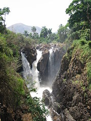
The area's accidented geography gives rise to several waterfall
Waterfall
A waterfall is a place where flowing water rapidly drops in elevation as it flows over a steep region or a cliff.-Formation:Waterfalls are commonly formed when a river is young. At these times the channel is often narrow and deep. When the river courses over resistant bedrock, erosion happens...
s along these waterways. Ekon Falls near Nkongsamba
Nkongsamba
Nkongsamba is a city in western Cameroon. It is located in the Moungo department, which is in the Littoral region. The city had a population of 104,050 inhabitants at the 2005 Census. The city is a centre of farming of oil palms, bananas and coffee, and is situated between two mountains, the...
in the West Province is 80 meters high.
Crater lake
Crater lake
A crater lake is a lake that forms in a volcanic crater or caldera, such as a maar; less commonly and with lower association to the term a lake may form in an impact crater caused by a meteorite. Sometimes lakes which form inside calderas are called caldera lakes, but often this distinction is not...
s dot the plateau, the result of dead volcanoes filling with water.
Flora
The Western High Plateau was once heavily forested. However, repeated cutting and burning by human beings has forced the forest back to areas along the waterways and has allowed grasslands to expand into the area.Sudan savanna
Savanna
A savanna, or savannah, is a grassland ecosystem characterized by the trees being sufficiently small or widely spaced so that the canopy does not close. The open canopy allows sufficient light to reach the ground to support an unbroken herbaceous layer consisting primarily of C4 grasses.Some...
forms the dominant vegetation. This consists of grassfields—leading to the name Bamenda grassfields around the city of Bamenda
Bamenda
Bamenda, also known as Abakwa and Mankon Town, is a city in northwestern Cameroon and capital of the North West Province. The city had a population of 269,530 at the 2005 Census, and is located 366 km north-west of the Cameroonian capital, Yaoundé...
—and short shrubs and trees that shed their foliage during the dry season as a defence against brush fires and dry weather. Raffia palm
Raffia palm
The Raffia palms are a genus of twenty species of palms native to tropical regions of Africa, especially Madagascar, with one species also occurring in Central and South America. They grow up to 16 m tall and are remarkable for their compound pinnate leaves, the longest in the plant kingdom;...
s grow in the valleys and depressions.