
Aller
Encyclopedia
The Aller is a river, 211 kilometres (131.1 mi) long, in the states of Saxony-Anhalt
and Lower Saxony
in Germany. It is a right-hand, and hence eastern, tributary
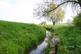
of the River Weser and is also its largest tributary. Its last 117 kilometres (72.7 mi) form the Lower Aller federal waterway (Bundeswasserstraße). The Aller was extensively straightened, widened and, in places, dyked, during the 1960s to provide flood control of the river. In a 20 kilometres (12.4 mi) long section near Gifhorn
the river meanders in its natural river bed.
near Seehausen and north of Oschersleben (Bode). It has several source streams that run down the northeastern side of the Hohes Holz
within the municipal boundaries of Wormsdorf
(part of Gehringsdorf), Ovelgünne
(part of Siegersleben) and Eggenstedt
. The Eggenstedt tributary is the most southerly of the source streams. The nearest large centres of population in the source region are Helmstedt
, about 20 km northwest, and Magdeburg
around 25 km east.
Initially the Aller flows rather like a canalised brook in a northwestern direction through low hills and intensively farmed arable fields. As it does it passes the Flechtingen Hills
to the east and another range of hills to the west that stretches from the Lappwald
over the Hohes Holz
as far as Oschersleben (Bode). The river passes the villages of Eilsleben
and Weferlingen
. After about 60 river kilometres it reaches Oebisfelde
and the southern edge of the Drömling
. After crossing the state border between Saxony-Anhalt and Lower Saxony the Aller bends sharply southwest near Grafhorst
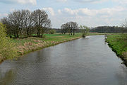
. Here the terrain is already only about 55 m above sea level. Between here and its mouth, 150 km away, its height drops by only about 40 m, so that the speed of the current is considerably reduced in Lower Saxony. Near Grafhorst the Aller meets the Breslau-Magdeburg-Bremen glacial valley and then, for the most part, follows it. From here on the river mainly runs through grassland
.
Near Wolfsburg-Wendschott the Aller passes under the Mittelland Canal in a culvert
where there is a barrier that is impassable to fish.
The Aller swings northwest again from Wolfsburg
. In the area of the town it crosses the Aller Park
and flows past the Allersee
before flowing past the Barnbruch
.
South of Weyhausen
the Aller Canal
branches off the Aller. The canal was built between 1860 and 1863 and is about 18 km long. It was supposed to drain the long-standing floods that were greatly feared at that time. The canal runs parallel to, and generally a few miles south of, the Aller, rejoining it near Brenneckenbrück (west of Gifhorn). The canal runs south past Gifhorn, whilst the Aller flows through the town. This 20 km long section which parallels the Aller Canal is the only section of the Aller which meanders in its natural river channel. Elsewhere the Aller has been straightened and widened along its entire length from source to mouth. East of Gifhorn near Osloß
it crosses under the Elbe Lateral Canal, which is carried over it on an aqueduct
. After that it runs via Gifhorn
to Müden
, where it merges with the Oker
.
is referred to as the Middle Aller (Mittelaller). After passing Wienhausen
it is navigable as far as Celle. Here the river has so much water that there are barrage
s and the water power is extracted from the river using weir
s.
30 kilometres (18.6 mi)
. Near Eickeloh
a reaction ferry
crosses the Aller and it is here that the River Leine flows into the Aller. Thereafter it passes Ahlden and Rethem and runs on to Verden. About 4 kilometres northwest of the town, near Eißel, a village in the borough of Verden, the Aller finally discharges into the Weser.
drainage channel of the Aller glacial valley, part of the Breslau-Magdeburg-Bremen glacial valley. The valley, which on average is 20 km wide, was formed during the penultimate ice age, the Saale glaciation about 200,000 years ago and drained meltwater
s from the ice sheet
into the North Sea
. The present course of the Aller in the miles-wide glacial valley does not reflect the courses of numerous streams of earlier centuries and millennia. For a long time there was a system of interwoven water courses, that changed their location and size depending on the materials and quantities of water being carried. Today there is a large number of dry oxbow lake
s, river beds and branches in the water meadows. Climatic conditions and the work of erosion
also changed the landscape around the streams of the glacial valley. For example, the wind formed inland sand dunes parallel to the river, especially on the northern side of the valley, around which the river sometimes snaked in meanders.
Near Wolfsburg the level of the river bed scarcely dropped at all and during times of low water it became almost an area of standing water. The Wolfsburg Volkswagen Factory uses the river and also feeds waste water, after cleaning, into its own sewage works.
Today the landscape of the Aller valley between Celle and Verden is mainly utilised as grassland
. The Aller depression there comprises valley floors lying close to the watertable, so that fertile wet areas may be found here with rich habitats for flora and fauna. The landscape is characterised by ox bows, potholes, copses and rows of bushes. The valley floors are widened by the depressions of the tributaries flowing into to the Aller, so that fens and bogs can form. Around the lower reaches crops are cultivated on the clay soils. Around the upper course of the river, many pine forests are managed on the sandy soils.
near Müden (Aller)
, the Fuhse
in Celle , and the Leine
near Schwarmstedt
. If the Leine is counted as a source stream for the Aller, it has a total length of 346 kilometres (215 mi).
From the right the Aller is joined by smaller rivers that predominantly drain the Lüneburg Heath
. Those worth mentioning include the Kleine Aller
fairly near Weyhausen
, the Ise
in Gifhorn, the Lachte
east of Celle
(near Lachtehausen), the Örtze
near Winsen (Aller)
, the Meiße
near Hodenhagen
and the Böhme near Rethem
.
:
runs parallel to the Upper Aller between Wolfsburg and Gifhorn. The canal was built in the mid-19th century to reduce flooding. It has the following tributary streams:
, the Lehrde
near Kirchlinteln
-Hohenaverbergen, the Gohbach
near Verden-Eitze and, just before its mouth, the Halse near Verden-Dauelsen.
the attractive landscape of the Aller-Leine Valley
. The Aller flows gently through relatively natural surroundings alongside meadows and woods, small villages and country towns. As a result it is of great importance for those seeking relaxation in Lower Saxony with almost 4 million people in the conurbation of the Hanover-Brunswick-Göttingen-Wolfsburg Metropolitan Region. The Aller Cycle Way, which is around 250 kilometres (155.3 mi) long and generally follows the course of the river at some distance, is just one of the leisure attractions in the area. There are attempts to make tourism along the river more compatible with nature through the 'soft tourism' (Sanfte Tourismus) initiative, especially in the Aller-Leine Valley. Leisure options include canoeing or travelling by houseboat. Water skiing
is allowed on short sections of the lower river.
is the biggest tributary of the Weser. The catchment area
of the Aller covers 15744 square kilometres (6,078.8 sq mi), about one third that of the Weser itself. The water flow gauge at Rethem below the Aller's confluence with the Leine registers an average volumentric flow of 114 cubic metres (4,025.9 cu ft) per second.
The Aller receives via the Oker
about half the run off from the Harz mountains (the other half drains into the Elbe via the Saale
and other tributaries). Consequently the Aller was and is frequently flooded by its tributaries. Since the commissioning of the dam
s in the Harz it is now possible to limit the impact, especially of seasonal floods, e.g. by delaying and slowing down the release of meltwaters on the Oker and Ecker
, the Innerste
and the Grane
in spring. As a result the discharge of the Aller into the Weser can be largely controlled and, although the level varies, it can be kept within boundaries.
Very little of the Aller is shaded by woods (apart from the section along the Aller Canal
). Direct sunlight on much of the river encourages the growth of aquatic plant
s and, in the absence of shady trees along its banks, the water becomes quite warm during the summer months.
the water compares to a sluggish canal and, in some sections it is almost like a stretch of still water. Its sluggishness is due to the very gradual slope of the channel, that in Lower Saxony averages a mere 10–20 cm per kilometre. Even in the upper course of the river, the flow across the whole of the stream bed is uniformly slow, due to the river having been widened and straightened. Here the bed is covered by a mixture of sand and mud.
from about half a million people is piped into the upper reaches of the Aller between its source and Müden/Aller, both directly and via its tributaries. The sewage is treated by 40 large sewage plants. Sewage from the town of Wolfsburg, the only city along the river, is not discharged into the river, but dispersed by sewage farm
s. The chemical composition of the Aller shows that the sewage discharged into it has generally been treated sufficiently well.
. Harz rivers, such as the Aller tributary of the Oker
, picked up heavy metals from the mines and their spoil heaps. These were mainly cadmium, zinc and lead compounds that were concentrated into the suspended solids
in the river. In this way these chemicals were transported by the Oker into the Aller and Weser where they were deposited in the slacker-moving sections as sediment
s.
In 1999 investigations were carried out into the heavy metal content of the suspended material in the Aller near Verden. They showed that the Aller was polluting the Weser disproportionally with lead
, cadmium
, zinc
and mercury
.
level of the Aller overall as moderately polluted (quality level II). Some individual indicators were rated as quality level I (unpolluted to very lightly polluted), some however showed heavy levels of pollution (quality levels III-IV). Heavy pollution is predominantly caused by nitrate
s. Pollution by ammonium
in places is ascribed to the unsatisfactory operation of certain sewage works. Raised phosphate
values were put down to intensive arable farming near the source of the river. Its salt
content today is above the critical level for aquatic plant
s. Since 1990 the salt content has reduced considerably which may be connected with lower discharges from the former East German area following the Wende
in 1989. Biological water quality
, based on the research into its saprobian systems, is generally rated as unpolluted to very lightly polluted. The only area that is critically contaminated is the region of Wolfsburg, where deposits of digested sludge
in the river are responsible.
and Oker
rivers following snowmelt
in the Leine Uplands
and the Harz
. In the upper courses the Aller filled the flat, swampy basin of the Drömling
from which the water drained only slowly. In addition the Ohre
flowed diffusely through the Drömling. Because the watershed between Weser and Elbe
lay in the middle of the Drömling, the river could even change its course so that the waters of the Aller flowed into the Elbe. The Prussian king, Frederick the Great, had the Prussian-owned eastern part of the Drömling drained between 1780 and 1796 and cleared for settlers (Kolonisten). His neighbours in western Drömling, in the shape of the Duchy of Brunswick
and Hanover did not join the drainage project and only began to drain and control the Aller from 1860 onwards. They built the 20 km long Aller-Ohre Canal from Grafhorst
in the area of Calvörde
, through which the waters of the Aller could flow into the Ohre. Another canal built to prevent floods was the Aller Canal
, finished in 1863, which protected the Aller depression near Gifhorn
. The construction of the Mittelland Canal in the 1930s enabled surplus water from the Aller to be drained off. That is achieved near Grafhorst by the Aller relief channel, a 3 km long canal. In spite of these measures there were floods in the Aller valley even in the 20th century that led to heavy losses for agriculture in the region.
near Gifhorn in the 1970s. By contrast, plans for a retention basin on the bend in the Aller near Grafhorst
were scrutinised between 1993 and 1996 on environmental grounds. The planned 12.5 square kilometres (4.8 sq mi) "Fahle Heide" basin west of Gifhorn was never built due to lack of funding. As part of the widening of the Aller the banks were reshaped along large stretches. The state purchased strips of land up to 12 m wide from those living along its the banks. The banks were made flatter and lined with stones. Willows, alder and reed beds were planted. The Upper Aller was widened to 15 m, the Middle Aller to 30 m and the Lower Aller from its confluence with the Leine to 50 m. Flood embankments were built along the Lower Aller near Rethem (Aller), Westen and Häuslingen
.
 As early as the 1980s the town of Celle had drawn up a "Plan for Flood Protection of the Celle Region". This described a combination of widely varying measures, such as excavation of the river shore, flood basins and dykes. On 6 June 2005 the town received authority to start the first stage of the flood protection project. In 2006 work was begun. This first part of the work entailed excavation of the river shore between Boye and the confluence with the river Fuhse, which were intended to increase the cross-section of the Aller channel during high water periods. The flood basins have an area of about 15 hectares (37.1 acre) and are 1½ metres deep, requiring about 240,000 m³ of earth to be washed away. The cost of the project came to around 2 million euros. Only two years later it was determined that these first interventions of the river system had resulted in sand being permanently deposited in the Aller producing shoals. In May 2009 the shipping channel was dredged for the first time in the vicinity of the new flood basins so that ships could once again pass through. Now it is planned to redesign the basins and, in some cases to fill them in, in order to reduce the dumping of sand in the future.
near Grafhorst
- designed to raise the water level during summer droughts - since it has been given a fish ladder
. The migration of fish is however prevented by weirs near Gifhorn and Müden (Aller)
and the locks of the Mittelland Canal near Wolfsburg-Wendschott. The Elbe Lateral Canal near Osloß
flows freely under the Aller, however.
has plied the river Aller for hundreds of years. It contributed to the economic growth of Brunswick
, because the control of river transport fell into the hands of Duke Henry the Lion
. Metals from the Harz
were transported from Brunswick to the North Sea initially down the Oker and then down the Aller and Weser rivers. In the 14th century Celle was the most important grain loading point
in the region that is today Lower Saxony. Around 1500 the ships on the Aller already had a capacity of about 60 tons. The section of the Lower Aller between Celle and Verden had a particular high economic significance for shipping.
Nevertheless, maintenance, repairs and modifications were very expensive. Between 1908 and 1918 the Aller was widened to provide permanent navigability between Celle and Verden. Four barrages were built, with locks for ships. At the beginning of the 20th century potash salt, that had been extracted near Celle, was transported in large quantities on the Aller. Today there are no commercial ships left.
Since the mid-1960s only pleasure cruisers and sports boats have been used on the river above Verden towards its source.
decided to canalise the Aller from above its confluence with the Leine near Schwarmstedt
downstream to Celle. In the years 1908 to 1918 the river was regulated by four barrages with locks and thus made navigable for larger inland ships. In particular the Aller locks in Bannetze and Oldau enabled the transportation of crude oil from the oilfields of Wietze
to Celle. Likewise grain was shipped to Celle for milling.
town of Celle. At first the nobility had the wood transported as fuel to heat Celle Castle
and other royal buildings. The timber was felled in the royal forests. The transportation of logs by raft was roughly 10 times more efficient than moving it by horse and cart.
A major rafting operation took place on the Aller in 1680 when a large quantity of construction wood was floated down to the Weser and its mouth. The wood came from the southern Lüneburg Heath
and was used to build around 100 houses in the Swedish fort of Carlsburg on the site of present-day Bremerhaven
.
From the 17th century wood was also rafted down the Aller tributaries, such as the Ise
and Örtze
to Celle. In Celle the logs collected at a needle dam
in the Aller Land and were stored in a wood yard. Rafts also ran past Celle and down the Weser to Bremen. After the death of George William, Duke of Brunswick-Lüneburg
in 1705, timber rafting on the Upper Aller to Celle fell into decline. When the royal household moved to Hanover, Celle lost the baroque
lustre of a Residenz town. Raft dealers took over the business. On the Lower Aller timber rafting flourished again at the end of the 19th century during the Gründerzeit
. There was a large demand for wood in Bremen
, Bremerhaven
and the Weser Marshes, where wood was used for the construction of houses and shipbuilding. In the years around 1895 about 8,000 solid cubic metres of wood were rafted down to the Weser. After the First World War timber rafting on the Aller dwindled to nothing.
between 1908 and 1918, hydropower stations were built at two of the four new barrage
s: Oldau
and Marklendorf. They enabled the electrification
of the Südheide
. The Oldau station, with 3 Francis turbine
s, was taken over in 1929 by PreussenElektra
. In 1972 the power stations were closed as they were unprofitable. Whilst the structure in Marklendorf was demolished, the power station in Oldau was declared a technological monument and escaped destruction. After being modernised in 1983 it rejoined the grid. It has largely been preserved in its original state. Here the water power of the Aller, with the aid of Francis turbines with a nominal power
of 650 kW, is used to generate 3 million kWh per year of electrical current.
Saxony-Anhalt
Saxony-Anhalt is a landlocked state of Germany. Its capital is Magdeburg and it is surrounded by the German states of Lower Saxony, Brandenburg, Saxony, and Thuringia.Saxony-Anhalt covers an area of...
and Lower Saxony
Lower Saxony
Lower Saxony is a German state situated in north-western Germany and is second in area and fourth in population among the sixteen states of Germany...
in Germany. It is a right-hand, and hence eastern, tributary
Tributary
A tributary or affluent is a stream or river that flows into a main stem river or a lake. A tributary does not flow directly into a sea or ocean...
of the River Weser and is also its largest tributary. Its last 117 kilometres (72.7 mi) form the Lower Aller federal waterway (Bundeswasserstraße). The Aller was extensively straightened, widened and, in places, dyked, during the 1960s to provide flood control of the river. In a 20 kilometres (12.4 mi) long section near Gifhorn
Gifhorn
Gifhorn is a town and capital of the district Gifhorn in the east of Lower Saxony, Germany. It has a population of about 42,000 and is mainly influenced by the small distance to the industrial and commercially important cities nearby, Brunswick and Wolfsburg...
the river meanders in its natural river bed.
Meaning of the name
The river's name, which was recorded in 781 as Alera, in 803 as Elera, in 1096 as Alara, has two possible derivations:- A shortened form of *Eleraha, where *Eler in Old GermanOld GermanOld German usually refers to Old High German, but it could also refer to:*Old Low German *Altdeutsche Tracht , a dress style popular among early 19th century German radicals...
*olisa or Old SlavicOld SlavicOld Slavic may refer to:*the Old Church Slavonic language*the Proto-Slavic language language...
olsa (Polish: olsza) would mean Erle ("alder") and aha is an old word frequently used in river names to mean "water" (c.f. the LatinLatinLatin is an Italic language originally spoken in Latium and Ancient Rome. It, along with most European languages, is a descendant of the ancient Proto-Indo-European language. Although it is considered a dead language, a number of scholars and members of the Christian clergy speak it fluently, and...
aqua). The name of the tree passed into Low GermanLow GermanLow German or Low Saxon is an Ingvaeonic West Germanic language spoken mainly in northern Germany and the eastern part of the Netherlands...
as Eller which is very close to the word Aller. Aller would therefore mean something like Erlenwasser i.e. "alder water", which was probably due to the river banks being largely covered in alderAlderAlder is the common name of a genus of flowering plants belonging to the birch family . The genus comprises about 30 species of monoecious trees and shrubs, few reaching large size, distributed throughout the North Temperate Zone and in the Americas along the Andes southwards to...
trees that prefer wet locations. - In Hans KraheHans KraheHans Krahe was a German philologist and linguist, specializing over many decades in the Illyrian languages. He was born at Gelsenkirchen....
's system of Old European hydronomy the old name for the Aller, Alara, is an example of a group of river names with the root al- that is very common over much of Europe and according to Krahe all go back to the Indo-EuropeanIndo-EuropeanIndo-European may refer to:* Indo-European languages** Aryan race, a 19th century and early 20th century term for those peoples who are the native speakers of Indo-European languages...
root *el-/*ol- which means "flowing". Similarly related would be rivers such as the AlsterAlsterThe Alster is a right tributary of the River Elbe in Northern Germany. It has its source near Henstedt-Ulzburg, Schleswig-Holstein, flows roughly southwards and reaches the Elbe in Hamburg. In the centre of Hamburg the Alster has been dammed...
, IllerIllerThe Iller is a river in Bavaria, Germany. It is a right tributary of the Danube, 147 km in length.The source is located near Oberstdorf in the Allgäu region of the Alps, close to the Austrian border. From there it runs northwards, passing the towns of Sonthofen, Immenstadt, and Kempten...
, ElzElzElz is a geographical name with multiple occurrences in Germany* Elz , a river rising in the Odenwald and flowing into the Neckar.* Elz , a river rising in the Black Forest and flowing into the Rhine....
or Ilmenau. Krahe's hypothesis is however hotly disputed in language circles. Theo VennemannTheo VennemannTheo Vennemann is a German linguist known best for his work on historical linguistics, especially for his disputed theories of a Vasconic substratum and an Atlantic superstratum of European languages. He also suggests that the High German consonant shift was already completed in the early 1st...
used a modified version of Krahe's model in his Vasconic substratum theory.
Upper Aller
The Aller rises in the state of Saxony-Anhalt in the west of the region known as the Magdeburg BördeMagdeburg Börde
The Magdeburg Börde is the central landscape unit of the state of Saxony-Anhalt and lies to the West and South of the eponymous state capital Magdeburg. It is noted for its very fertile soils.- Boundaries :...
near Seehausen and north of Oschersleben (Bode). It has several source streams that run down the northeastern side of the Hohes Holz
Hohes Holz
The Hohes Holz is the only large wooded area in the otherwise open, agriculturally intensively-farmed western part of the Magdeburg Börde in the German state of Saxony-Anhalt. The region forms the southern part of a ridge that runs from the Lappwald in the north to the Bodeknie near Oschersleben ....
within the municipal boundaries of Wormsdorf
Wormsdorf
Wormsdorf is a village and a former municipality in the Börde district in Saxony-Anhalt, Germany. Since 1 January 2010, it is part of the municipality Eilsleben....
(part of Gehringsdorf), Ovelgünne
Ovelgünne
Ovelgünne is a village and a former municipality in the Börde district in Saxony-Anhalt, Germany. Since 1 September 2010, it is part of the municipality Eilsleben....
(part of Siegersleben) and Eggenstedt
Eggenstedt
Eggenstedt is a village and a former municipality in the Börde district in Saxony-Anhalt, Germany. Since 1 January 2010, it is part of the town Wanzleben-Börde....
. The Eggenstedt tributary is the most southerly of the source streams. The nearest large centres of population in the source region are Helmstedt
Helmstedt
Helmstedt is a city located at the eastern edge of the German state of Lower Saxony. It is the capital of the District of Helmstedt. Helmstedt has 26,000 inhabitants . In former times the city was also called Helmstädt....
, about 20 km northwest, and Magdeburg
Magdeburg
Magdeburg , is the largest city and the capital city of the Bundesland of Saxony-Anhalt, Germany. Magdeburg is situated on the Elbe River and was one of the most important medieval cities of Europe....
around 25 km east.
Initially the Aller flows rather like a canalised brook in a northwestern direction through low hills and intensively farmed arable fields. As it does it passes the Flechtingen Hills
Flechtingen Hills
The Flechtingen Hills are a wooded, hilly upland area up to 179 m high in the northwestern part of the German state of Saxony-Anhalt, named after the town of Flechtingen.- Location :...
to the east and another range of hills to the west that stretches from the Lappwald
Lappwald
The Lappwald is a heavily wooded range of hills, 20 km long and up to 5 km wide, in central Germany. It stretches northwards from the town of Helmstedt. The border between Lower Saxony and Saxony-Anhalt runs through the woods, of which about three quarters is on Lower Saxon terrain...
over the Hohes Holz
Hohes Holz
The Hohes Holz is the only large wooded area in the otherwise open, agriculturally intensively-farmed western part of the Magdeburg Börde in the German state of Saxony-Anhalt. The region forms the southern part of a ridge that runs from the Lappwald in the north to the Bodeknie near Oschersleben ....
as far as Oschersleben (Bode). The river passes the villages of Eilsleben
Eilsleben
Eilsleben is a municipality in the Börde district in Saxony-Anhalt, Germany....
and Weferlingen
Weferlingen
Weferlingen is a village and a former municipality in the Börde district in Saxony-Anhalt, Germany. Since 1 January 2010, it is part of the town Oebisfelde-Weferlingen....
. After about 60 river kilometres it reaches Oebisfelde
Oebisfelde
Oebisfelde is a village and a former municipality in the Börde district in Saxony-Anhalt, Germany. Since 1 January 2010, it is part of the town Oebisfelde-Weferlingen. It is accessed by Bundesstraße 188.- Geography :...
and the southern edge of the Drömling
Drömling
The Drömling is a sparsely populated depression on the border of Lower Saxony and Saxony-Anhalt in Germany with an area of about . The larger part belonging to Saxony-Anhalt in the east has been a nature park since 1990. The former swampland was transformed by drainaged from a natural into a...
. After crossing the state border between Saxony-Anhalt and Lower Saxony the Aller bends sharply southwest near Grafhorst
Grafhorst
Grafhorst is a small town about 3 km north of Kampen, in the Dutch province of Overijssel. It received city rights in 1333....
. Here the terrain is already only about 55 m above sea level. Between here and its mouth, 150 km away, its height drops by only about 40 m, so that the speed of the current is considerably reduced in Lower Saxony. Near Grafhorst the Aller meets the Breslau-Magdeburg-Bremen glacial valley and then, for the most part, follows it. From here on the river mainly runs through grassland
Grassland
Grasslands are areas where the vegetation is dominated by grasses and other herbaceous plants . However, sedge and rush families can also be found. Grasslands occur naturally on all continents except Antarctica...
.
Near Wolfsburg-Wendschott the Aller passes under the Mittelland Canal in a culvert
Culvert
A culvert is a device used to channel water. It may be used to allow water to pass underneath a road, railway, or embankment. Culverts can be made of many different materials; steel, polyvinyl chloride and concrete are the most common...
where there is a barrier that is impassable to fish.
The Aller swings northwest again from Wolfsburg
Wolfsburg
Wolfsburg is a town in Lower Saxony, Germany. It is located on the River Aller northeast of Braunschweig , and is mainly notable as the headquarters of Volkswagen AG...
. In the area of the town it crosses the Aller Park
Aller Park
The Aller Park is a park in Wolfsburg in the German state of Lower Saxony. It lies between the districts of Nordstadt, Stadtmitte and Neuhaus/Reislingen....
and flows past the Allersee
Allersee
Allersee is a lake in Wolfsburg, Lower Saxony, Germany. At an elevation of 57 m, its surface area is 0.29 km²....
before flowing past the Barnbruch
Barnbruch
The Barnbruch is a wetland of international importance in the old glacial valley of the river Aller that provides a habitat for endangered species of birds, amphibians and insects. It lies between the city of Wolfsburg and town of Gifhorn and consists of an enclosed woodland area of around with...
.
South of Weyhausen
Weyhausen
Weyhausen is a municipality in the district of Gifhorn, in Lower Saxony, Germany.-History:The earliest surviving record dates from 1344, naming the settlement as Weydehusen. In 1350 it was rebuilt following destruction by fire...
the Aller Canal
Aller Canal
The Aller Canal is a canal built in the mid-19th century in the German state of Lower Saxony. The canal is long and runs between Wolfsburg and Gifhorn. It was built to protect agricultural land from flooding by the river Aller...
branches off the Aller. The canal was built between 1860 and 1863 and is about 18 km long. It was supposed to drain the long-standing floods that were greatly feared at that time. The canal runs parallel to, and generally a few miles south of, the Aller, rejoining it near Brenneckenbrück (west of Gifhorn). The canal runs south past Gifhorn, whilst the Aller flows through the town. This 20 km long section which parallels the Aller Canal is the only section of the Aller which meanders in its natural river channel. Elsewhere the Aller has been straightened and widened along its entire length from source to mouth. East of Gifhorn near Osloß
Osloß
Osloß is a municipality in the district of Gifhorn, in Lower Saxony, Germany....
it crosses under the Elbe Lateral Canal, which is carried over it on an aqueduct
Aqueduct
An aqueduct is a water supply or navigable channel constructed to convey water. In modern engineering, the term is used for any system of pipes, ditches, canals, tunnels, and other structures used for this purpose....
. After that it runs via Gifhorn
Gifhorn
Gifhorn is a town and capital of the district Gifhorn in the east of Lower Saxony, Germany. It has a population of about 42,000 and is mainly influenced by the small distance to the industrial and commercially important cities nearby, Brunswick and Wolfsburg...
to Müden
Müden (Aller)
Müden is a municipality in the district of Gifhorn, in Lower Saxony, Germany....
, where it merges with the Oker
Oker
The Oker is a river in Lower Saxony, Germany, that has historically formed an important political boundary. It is a left tributary of the River Aller, in length and runs in a generally northerly direction.- Course :...
.
Middle Aller
The 30 kilometre-long (20 mi) section of the Aller from the mouth of the Oker to CelleCelle
Celle is a town and capital of the district of Celle, in Lower Saxony, Germany. The town is situated on the banks of the River Aller, a tributary of the Weser and has a population of about 71,000...
is referred to as the Middle Aller (Mittelaller). After passing Wienhausen
Wienhausen
Wienhausen is a municipality in the district of Celle, in Lower Saxony, Germany. It is known for Wienhausen Abbey, referenced in the municipal coat of arms....
it is navigable as far as Celle. Here the river has so much water that there are barrage
Barrage
Barrage may refer to:In music* Barrage , a Canadian violin ensemble, or* Barrage , their self-titled debut albumIn engineering...
s and the water power is extracted from the river using weir
Weir
A weir is a small overflow dam used to alter the flow characteristics of a river or stream. In most cases weirs take the form of a barrier across the river that causes water to pool behind the structure , but allows water to flow over the top...
s.
30 kilometres (18.6 mi)
Lower Aller
The section of the river known as the Lower Aller (Unteraller) begins at Celle and runs for 120 kilometres (74.6 mi) to the Weser. The Lower Aller is a designated federal waterway (Bundeswasserstraße). The river is navigable from here to WinsenWinsen (Aller)
Winsen an der Aller or Winsen is a town in the district of Celle in the German state of Lower Saxony.-Geography:Winsen has around 12,900 inhabitants and lies on the southern perimeter of the Lüneburg Heath, on the banks of the Aller, somewhat to the west of its tributary, the Örtze and about...
. Near Eickeloh
Eickeloh
Eickeloh is a municipality in the Heidekreis district, in Lower Saxony, Germany....
a reaction ferry
Reaction ferry
A reaction ferry is a cable ferry that uses the reaction of the current of a river against a fixed tether to propel the vessel across the river...
crosses the Aller and it is here that the River Leine flows into the Aller. Thereafter it passes Ahlden and Rethem and runs on to Verden. About 4 kilometres northwest of the town, near Eißel, a village in the borough of Verden, the Aller finally discharges into the Weser.
Aller glacial valley
After the Aller had passed through the hills of Saxony-Anhalt, it entered the Wolfsburg area into the ice ageIce age
An ice age or, more precisely, glacial age, is a generic geological period of long-term reduction in the temperature of the Earth's surface and atmosphere, resulting in the presence or expansion of continental ice sheets, polar ice sheets and alpine glaciers...
drainage channel of the Aller glacial valley, part of the Breslau-Magdeburg-Bremen glacial valley. The valley, which on average is 20 km wide, was formed during the penultimate ice age, the Saale glaciation about 200,000 years ago and drained meltwater
Meltwater
Meltwater is the water released by the melting of snow or ice, including glacial ice and ice shelfs over oceans. Meltwater is often found in the ablation zone of glaciers, where the rate of snow cover is reducing...
s from the ice sheet
Ice sheet
An ice sheet is a mass of glacier ice that covers surrounding terrain and is greater than 50,000 km² , thus also known as continental glacier...
into the North Sea
North Sea
In the southwest, beyond the Straits of Dover, the North Sea becomes the English Channel connecting to the Atlantic Ocean. In the east, it connects to the Baltic Sea via the Skagerrak and Kattegat, narrow straits that separate Denmark from Norway and Sweden respectively...
. The present course of the Aller in the miles-wide glacial valley does not reflect the courses of numerous streams of earlier centuries and millennia. For a long time there was a system of interwoven water courses, that changed their location and size depending on the materials and quantities of water being carried. Today there is a large number of dry oxbow lake
Oxbow lake
An oxbow lake is a U-shaped body of water formed when a wide meander from the main stem of a river is cut off to create a lake. This landform is called an oxbow lake for the distinctive curved shape, named after part of a yoke for oxen. In Australia, an oxbow lake is called a billabong, derived...
s, river beds and branches in the water meadows. Climatic conditions and the work of erosion
Erosion
Erosion is when materials are removed from the surface and changed into something else. It only works by hydraulic actions and transport of solids in the natural environment, and leads to the deposition of these materials elsewhere...
also changed the landscape around the streams of the glacial valley. For example, the wind formed inland sand dunes parallel to the river, especially on the northern side of the valley, around which the river sometimes snaked in meanders.
Near Wolfsburg the level of the river bed scarcely dropped at all and during times of low water it became almost an area of standing water. The Wolfsburg Volkswagen Factory uses the river and also feeds waste water, after cleaning, into its own sewage works.
Today the landscape of the Aller valley between Celle and Verden is mainly utilised as grassland
Grassland
Grasslands are areas where the vegetation is dominated by grasses and other herbaceous plants . However, sedge and rush families can also be found. Grasslands occur naturally on all continents except Antarctica...
. The Aller depression there comprises valley floors lying close to the watertable, so that fertile wet areas may be found here with rich habitats for flora and fauna. The landscape is characterised by ox bows, potholes, copses and rows of bushes. The valley floors are widened by the depressions of the tributaries flowing into to the Aller, so that fens and bogs can form. Around the lower reaches crops are cultivated on the clay soils. Around the upper course of the river, many pine forests are managed on the sandy soils.
Rivers
The most important tributaries to join the Aller from its left-hand, southern, side facing the Harz mountains, are the OkerOker
The Oker is a river in Lower Saxony, Germany, that has historically formed an important political boundary. It is a left tributary of the River Aller, in length and runs in a generally northerly direction.- Course :...
near Müden (Aller)
Müden (Aller)
Müden is a municipality in the district of Gifhorn, in Lower Saxony, Germany....
, the Fuhse
Fuhse
The Fuhse is a stream of Lower Saxony, Germany, a left tributary of the Aller. Spelled Fuse in maps of the 19th century and earlier, the name is thought to derive from the ancient Fosa flumen, after which the Germanic tribe of the Fosi took their name .The Fuhse originates on the west slope of the...
in Celle , and the Leine
Leine
The Leine is a river in Thuringia and Lower Saxony, Germany. It is a left tributary of the Aller river and 281 km in length.The river's source is located close to the town of Leinefelde in Thuringia...
near Schwarmstedt
Schwarmstedt
Schwarmstedt is a municipality in the Heidekreis in Lower Saxony, Germany. It is situated near the confluence of the rivers Aller and Leine, approx. 20 km south of Bad Fallingbostel, and 30 km east of Nienburg...
. If the Leine is counted as a source stream for the Aller, it has a total length of 346 kilometres (215 mi).
From the right the Aller is joined by smaller rivers that predominantly drain the Lüneburg Heath
Lüneburg Heath
The Lüneburg Heath is a large area of heath, geest and woodland in northeastern part of the state of Lower Saxony in northern Germany. It forms part of the hinterland for the cities of Hamburg, Hanover, and Bremen and is named after the town of Lüneburg. Most of the area is a nature reserve...
. Those worth mentioning include the Kleine Aller
Kleine Aller
The Kleine Aller is a tributary of the Aller and Aller Canal in the German state of Lower Saxony. It is about long and up to wide, and flows from north to south through the district of Gifhorn and the city of Wolfsburg.- Course :...
fairly near Weyhausen
Weyhausen
Weyhausen is a municipality in the district of Gifhorn, in Lower Saxony, Germany.-History:The earliest surviving record dates from 1344, naming the settlement as Weydehusen. In 1350 it was rebuilt following destruction by fire...
, the Ise
Ise (river)
The Ise is a roughly 50 km long, almost natural river in East Lower Saxony, Germany, which crosses the district of Gifhorn from north to south and discharges into the Aller at Gifhorn itself.- Course :...
in Gifhorn, the Lachte
Lachte
The Lachte is a roughly long right-hand tributary of the River Aller in the Südheide Nature Park in the north German state of Lower Saxony.- Course :The Lachte rises in the northern part of the district of Gifhorn southwest of Sprakensehl...
east of Celle
Celle
Celle is a town and capital of the district of Celle, in Lower Saxony, Germany. The town is situated on the banks of the River Aller, a tributary of the Weser and has a population of about 71,000...
(near Lachtehausen), the Örtze
Örtze
The Örtze is a river in the North German state of Lower Saxony, which rises north of Munster in the Große Heide and, after , joins the Aller southeast of Winsen.- Source and course :...
near Winsen (Aller)
Winsen (Aller)
Winsen an der Aller or Winsen is a town in the district of Celle in the German state of Lower Saxony.-Geography:Winsen has around 12,900 inhabitants and lies on the southern perimeter of the Lüneburg Heath, on the banks of the Aller, somewhat to the west of its tributary, the Örtze and about...
, the Meiße
Meiße
The Meiße is a German river in the state of Lower Saxony, near the Lüneburg Heath, and a right-hand tributary of the River Aller.- Origin and course :The Meiße emerges south of Wietzendorf in the nature reserve of Großes Moor bei Becklingen...
near Hodenhagen
Hodenhagen
Hodenhagen is a municipality in the district of Heidekreis, in Lower Saxony, Germany. The town was once the site of Hudemühlen Castle, which is now completely destroyed. The castle was famous as the home of the kobold Hinzelmann. The site of another medieval castle, Hodenhagen Castle on the River...
and the Böhme near Rethem
Rethem
Rethem is a town in the Heidekreis in Lower Saxony, Germany. It is situated on the river Aller, approx. 25 km southwest of Bad Fallingbostel, and 18 km southeast of Verden...
.
Streams of the Upper Aller
The Upper Aller has numerous tributary streams between its source and MüdenMüden (Aller)
Müden is a municipality in the district of Gifhorn, in Lower Saxony, Germany....
:
|
Sassenburg-Triangel Triangel is a village in the municipality of Sassenburg in the Lower Saxon district of Gifhorn. Triangel means “triangle”. The name is derived from the original shape of the village estate.- Geographical location :... Moor Canal Barnbruch The Barnbruch is a wetland of international importance in the old glacial valley of the river Aller that provides a habitat for endangered species of birds, amphibians and insects. It lies between the city of Wolfsburg and town of Gifhorn and consists of an enclosed woodland area of around with... graben |
Neudorf-Platendorf Neudorf-Platendorf is a village in the municipality of Sassenburg in Gifhorn district in the German state of Lower Saxony.- Location :The village lies east of the River Ise and the state forest of Dragen.... Moorgraben |
Streams of the Aller Canal
The Aller CanalAller Canal
The Aller Canal is a canal built in the mid-19th century in the German state of Lower Saxony. The canal is long and runs between Wolfsburg and Gifhorn. It was built to protect agricultural land from flooding by the river Aller...
runs parallel to the Upper Aller between Wolfsburg and Gifhorn. The canal was built in the mid-19th century to reduce flooding. It has the following tributary streams:
|
Viehmoorgraben Viehmoorgraben is a river of Lower Saxony, Germany.... Vollbütteler Riede Vollbütteler Riede is a river of Lower Saxony, Germany.... |
Streams of the Lower Aller
From the left the following small rivers and brooks feed the Aller: the Alpe and the Wölpe near RethemRethem
Rethem is a town in the Heidekreis in Lower Saxony, Germany. It is situated on the river Aller, approx. 25 km southwest of Bad Fallingbostel, and 18 km southeast of Verden...
, the Lehrde
Lehrde
The Lehrde is a 22 km long, right tributary of the river Aller in Lower Saxony, Germany.- Course :It rises east of Kettenburg, a village in the borough of Visselhövede, in the Öttinger Ochsenmoor nature reserve. It then heads westward, crossing the district of Soltau-Fallingbostel ,passing the...
near Kirchlinteln
Kirchlinteln
Kirchlinteln is a municipality in the district of Verden, in Lower Saxony, Germany. Its central village is situated approximately 6 km east of Verden, and 40 km southeast of Bremen. It is surrounded by the Linteln Geest which is dominated by woods, hills, heath and small villages...
-Hohenaverbergen, the Gohbach
Gohbach
The Gohbach is a 20 km long, right-hand tributary of the Aller in Lower Saxony, Germany.- Course :The Gohbach rises in the district of Rotenburg in the borough of Visselhövede near the village of Dreeßel....
near Verden-Eitze and, just before its mouth, the Halse near Verden-Dauelsen.
Castles and monasteries
- Bartensleben Castle, built as a water castleWater castleA water castle is a castle or stately home whose site is entirely surrounded by moats or natural waterbodies. Topographically water castles are a type of lowland castle.There is a further distinction between:...
- Oebisfelde Castle, built as a Niederungsburg ("castle on the plain") probably in the 10th century on a sand bank in the Aller in a swamp area of the DrömlingDrömlingThe Drömling is a sparsely populated depression on the border of Lower Saxony and Saxony-Anhalt in Germany with an area of about . The larger part belonging to Saxony-Anhalt in the east has been a nature park since 1990. The former swampland was transformed by drainaged from a natural into a...
- Wolfsburg Castle, built as a residential tower in the 14th century on the Aller and expanded into a water castle with fortifications
- Gifhorn CastleGifhorn CastleGifhorn Castle is a castle in Gifhorn, Germany, built between 1525 and 1581 in the Weser Renaissance style. The castle was fortified until 1790 with moats, ramparts and bastions and was never captured...
, completed in 1581 with fortifications - Wienhausen Abbey, former Cistercian monastery from the 13th century
- Celle CastleCelle CastleCelle Castle or, less commonly, Celle Palace, in the German town of Celle in Lower Saxony was one of the residences of the House of Brunswick-Lüneburg...
, built in the 10th century as a fortified tower by a ford over the Aller - UhlenburgUhlenburgUhlenburg is the site of a lowland castle that was built in the 14th century close to the River Aller near Essel in the German state of Lower Saxony...
near EsselEsselEssel is a municipality in the Heidekreis district, in Lower Saxony, Germany. Most of the village is located on the southern bank of the river Aller. The A 7 motorway runs through the village.-Subdivisions:The municipality of Essel comprises 4 subdivisions:...
, built as a manor house in the 14th century - Blankenburg CastleBlankenburg CastleBlankenburg Castle was a small castle in the village of Engehausen in the municipality of Essel in the German state of Lower Saxony. It dates roughly to the 13th century. All that remains are parts of the surrounding rampart...
near Essel - Ahlden Castle, built in 1549 as a water castle on the Aller; where the river bed became part of the LeineLeineThe Leine is a river in Thuringia and Lower Saxony, Germany. It is a left tributary of the Aller river and 281 km in length.The river's source is located close to the town of Leinefelde in Thuringia...
from 1618 when the Aller changed its course - BunkenburgBunkenburgBunkenburg was a castle built during the 13th and 14th centuries in the shape of a circular fort located on the banks of the River Aller opposite Ahlden in north Germany. Only a section of the rampart, roughly 60 metres long and 3 metres high, exists today...
, built as a circular rampartCircular rampartA circular rampart is an embankment built in the shape of a circle that was used as part of the defences for a military fortification, hill fort or refuge, or was built for religious purposes or as a place of gathering....
on the Aller in Ahlden (Aller) in the 13th century - Hudemühlen Castle in the HodenhagenHodenhagenHodenhagen is a municipality in the district of Heidekreis, in Lower Saxony, Germany. The town was once the site of Hudemühlen Castle, which is now completely destroyed. The castle was famous as the home of the kobold Hinzelmann. The site of another medieval castle, Hodenhagen Castle on the River...
sector of Hudemühlen, built in the 14th century as a castle, converted in the 16th century into a RenaissanceWeser RenaissanceWeser Renaissance is a form of Renaissance architectural style that is found in the area around the River Weser in central Germany and which has been well-preserved in the towns and cities of the region.- Background :...
castle and demolished in the 19th century - Bierde Castle near Bierde
- Hodenhagen CastleHodenhagen CastleHodenhagen Castle is the site of a former lowland castle built in the 13th century in the vicinity of Hodenhagen in the German state of Lower Saxony...
near HodenhagenHodenhagenHodenhagen is a municipality in the district of Heidekreis, in Lower Saxony, Germany. The town was once the site of Hudemühlen Castle, which is now completely destroyed. The castle was famous as the home of the kobold Hinzelmann. The site of another medieval castle, Hodenhagen Castle on the River... - Blankenhagen CastleBlankenhagen CastleBlankenhagen Castle was a lowland castle , whose ruins are located by the River Aller near Grethem in Lower Saxony, Germany. The motte-and-bailey castle is believed to have been built around 1200...
near GrethemGrethemGrethem is a municipality in the district of Heidekreis, in Lower Saxony, Germany.... - Rethem Castle in Rethem (Aller), built in the 13th century and expanded into a bastioned site in the 17th century
- Verden Cathedral, built in the 12th century
Culture and tourism
The Aller is one of the few - at least to all appearances - undisturbed larger rivers in Germany. From Celle as far as the Verden area it forms, together with the LeineLeine
The Leine is a river in Thuringia and Lower Saxony, Germany. It is a left tributary of the Aller river and 281 km in length.The river's source is located close to the town of Leinefelde in Thuringia...
the attractive landscape of the Aller-Leine Valley
Aller-Leine Valley
The Aller-Leine Valley is the name of a region north of Hanover in Germany, that has been created for the purpose of regional marketing and inter-community cooperation...
. The Aller flows gently through relatively natural surroundings alongside meadows and woods, small villages and country towns. As a result it is of great importance for those seeking relaxation in Lower Saxony with almost 4 million people in the conurbation of the Hanover-Brunswick-Göttingen-Wolfsburg Metropolitan Region. The Aller Cycle Way, which is around 250 kilometres (155.3 mi) long and generally follows the course of the river at some distance, is just one of the leisure attractions in the area. There are attempts to make tourism along the river more compatible with nature through the 'soft tourism' (Sanfte Tourismus) initiative, especially in the Aller-Leine Valley. Leisure options include canoeing or travelling by houseboat. Water skiing
Water skiing
thumb|right|A slalom skier making a turn on a slalom waterski.Waterskiing is a sport where an individual is pulled behind a boat or a cable ski installation on a body of water, skimming the surface.-History:...
is allowed on short sections of the lower river.
Hydrology
The riverRiver
A river is a natural watercourse, usually freshwater, flowing towards an ocean, a lake, a sea, or another river. In a few cases, a river simply flows into the ground or dries up completely before reaching another body of water. Small rivers may also be called by several other names, including...
is the biggest tributary of the Weser. The catchment area
Drainage basin
A drainage basin is an extent or an area of land where surface water from rain and melting snow or ice converges to a single point, usually the exit of the basin, where the waters join another waterbody, such as a river, lake, reservoir, estuary, wetland, sea, or ocean...
of the Aller covers 15744 square kilometres (6,078.8 sq mi), about one third that of the Weser itself. The water flow gauge at Rethem below the Aller's confluence with the Leine registers an average volumentric flow of 114 cubic metres (4,025.9 cu ft) per second.
The Aller receives via the Oker
Oker
The Oker is a river in Lower Saxony, Germany, that has historically formed an important political boundary. It is a left tributary of the River Aller, in length and runs in a generally northerly direction.- Course :...
about half the run off from the Harz mountains (the other half drains into the Elbe via the Saale
Saale
The Saale, also known as the Saxon Saale and Thuringian Saale , is a river in Germany and a left-bank tributary of the Elbe. It is not to be confused with the smaller Franconian Saale, a right-bank tributary of the Main, or the Saale in Lower Saxony, a tributary of the Leine.-Course:The Saale...
and other tributaries). Consequently the Aller was and is frequently flooded by its tributaries. Since the commissioning of the dam
Dam
A dam is a barrier that impounds water or underground streams. Dams generally serve the primary purpose of retaining water, while other structures such as floodgates or levees are used to manage or prevent water flow into specific land regions. Hydropower and pumped-storage hydroelectricity are...
s in the Harz it is now possible to limit the impact, especially of seasonal floods, e.g. by delaying and slowing down the release of meltwaters on the Oker and Ecker
Ecker
Ecker is a river in Germany. It may also refer to:Entertainment*Meng and Ecker As a name:*Danny Ecker*Janet Ecker*Guy Ecker*Haylie Ecker*William Ecker*Tyler Ecker*Enrique Ecker*Alexander Ecker*Johnny Ecker...
, the Innerste
Innerste
The Innerste is a river in Lower Saxony, Germany. It is a right tributary of the Leine river and 95 km in length.- Origin of the name :...
and the Grane
Grane (river)
The Grane is a right tributary of the Innerste river near Goslar.It rises in the vicinity of Hahnenklee in the Upper Harz and discharges about 12 km later into the Innerste near Langelsheim . At Herzog Juliushütte, in the municipality of Astfeld near Goslar, it is controlled by the Grane Dam....
in spring. As a result the discharge of the Aller into the Weser can be largely controlled and, although the level varies, it can be kept within boundaries.
Very little of the Aller is shaded by woods (apart from the section along the Aller Canal
Aller Canal
The Aller Canal is a canal built in the mid-19th century in the German state of Lower Saxony. The canal is long and runs between Wolfsburg and Gifhorn. It was built to protect agricultural land from flooding by the river Aller...
). Direct sunlight on much of the river encourages the growth of aquatic plant
Aquatic plant
Aquatic plants are plants that have adapted to living in aquatic environments. They are also referred to as hydrophytes or aquatic macrophytes. These plants require special adaptations for living submerged in water, or at the water's surface. Aquatic plants can only grow in water or in soil that is...
s and, in the absence of shady trees along its banks, the water becomes quite warm during the summer months.
Water velocity
The water velocity of the Aller is very slow in places. In its upper reaches at the height of the DrömlingDrömling
The Drömling is a sparsely populated depression on the border of Lower Saxony and Saxony-Anhalt in Germany with an area of about . The larger part belonging to Saxony-Anhalt in the east has been a nature park since 1990. The former swampland was transformed by drainaged from a natural into a...
the water compares to a sluggish canal and, in some sections it is almost like a stretch of still water. Its sluggishness is due to the very gradual slope of the channel, that in Lower Saxony averages a mere 10–20 cm per kilometre. Even in the upper course of the river, the flow across the whole of the stream bed is uniformly slow, due to the river having been widened and straightened. Here the bed is covered by a mixture of sand and mud.
Sewage
SewageSewage
Sewage is water-carried waste, in solution or suspension, that is intended to be removed from a community. Also known as wastewater, it is more than 99% water and is characterized by volume or rate of flow, physical condition, chemical constituents and the bacteriological organisms that it contains...
from about half a million people is piped into the upper reaches of the Aller between its source and Müden/Aller, both directly and via its tributaries. The sewage is treated by 40 large sewage plants. Sewage from the town of Wolfsburg, the only city along the river, is not discharged into the river, but dispersed by sewage farm
Sewage farm
Sewage farms comprise agricultural land irrigated and fertilised with sewage.A precursor to modern sewage treatment systems, household sewage was collected from towns and cities and transported to nearby farm lands. During the middle ages this was accomplished with hand-carried buckets, but as...
s. The chemical composition of the Aller shows that the sewage discharged into it has generally been treated sufficiently well.
Heavy metal pollution
The pollution of the Aller by heavy metals has resulted from centuries of mining in the Harz mountainsMining in the Upper Harz
Mining in the Upper Harz region of central Germany was a major industry for several centuries, especially for the production of silver, lead, copper, and, latterly, zinc as well. Great wealth was accumulated from the mining of silver from the 16th to the 19th centuries, as well as from important...
. Harz rivers, such as the Aller tributary of the Oker
Oker
The Oker is a river in Lower Saxony, Germany, that has historically formed an important political boundary. It is a left tributary of the River Aller, in length and runs in a generally northerly direction.- Course :...
, picked up heavy metals from the mines and their spoil heaps. These were mainly cadmium, zinc and lead compounds that were concentrated into the suspended solids
Suspended solids
Suspended solids refers to small solid particles which remain in suspension in water as a colloid or due to the motion of the water. It is used as one indicator of water quality....
in the river. In this way these chemicals were transported by the Oker into the Aller and Weser where they were deposited in the slacker-moving sections as sediment
Sediment
Sediment is naturally occurring material that is broken down by processes of weathering and erosion, and is subsequently transported by the action of fluids such as wind, water, or ice, and/or by the force of gravity acting on the particle itself....
s.
In 1999 investigations were carried out into the heavy metal content of the suspended material in the Aller near Verden. They showed that the Aller was polluting the Weser disproportionally with lead
Lead
Lead is a main-group element in the carbon group with the symbol Pb and atomic number 82. Lead is a soft, malleable poor metal. It is also counted as one of the heavy metals. Metallic lead has a bluish-white color after being freshly cut, but it soon tarnishes to a dull grayish color when exposed...
, cadmium
Cadmium
Cadmium is a chemical element with the symbol Cd and atomic number 48. This soft, bluish-white metal is chemically similar to the two other stable metals in group 12, zinc and mercury. Similar to zinc, it prefers oxidation state +2 in most of its compounds and similar to mercury it shows a low...
, zinc
Zinc
Zinc , or spelter , is a metallic chemical element; it has the symbol Zn and atomic number 30. It is the first element in group 12 of the periodic table. Zinc is, in some respects, chemically similar to magnesium, because its ion is of similar size and its only common oxidation state is +2...
and mercury
Mercury (element)
Mercury is a chemical element with the symbol Hg and atomic number 80. It is also known as quicksilver or hydrargyrum...
.
Water quality
The Lower Saxon water quality report of 2004 assessed the chemical water pollutionWater pollution
Water pollution is the contamination of water bodies . Water pollution occurs when pollutants are discharged directly or indirectly into water bodies without adequate treatment to remove harmful compounds....
level of the Aller overall as moderately polluted (quality level II). Some individual indicators were rated as quality level I (unpolluted to very lightly polluted), some however showed heavy levels of pollution (quality levels III-IV). Heavy pollution is predominantly caused by nitrate
Nitrate
The nitrate ion is a polyatomic ion with the molecular formula NO and a molecular mass of 62.0049 g/mol. It is the conjugate base of nitric acid, consisting of one central nitrogen atom surrounded by three identically-bonded oxygen atoms in a trigonal planar arrangement. The nitrate ion carries a...
s. Pollution by ammonium
Ammonium
The ammonium cation is a positively charged polyatomic cation with the chemical formula NH. It is formed by the protonation of ammonia...
in places is ascribed to the unsatisfactory operation of certain sewage works. Raised phosphate
Phosphate
A phosphate, an inorganic chemical, is a salt of phosphoric acid. In organic chemistry, a phosphate, or organophosphate, is an ester of phosphoric acid. Organic phosphates are important in biochemistry and biogeochemistry or ecology. Inorganic phosphates are mined to obtain phosphorus for use in...
values were put down to intensive arable farming near the source of the river. Its salt
Salt
In chemistry, salts are ionic compounds that result from the neutralization reaction of an acid and a base. They are composed of cations and anions so that the product is electrically neutral...
content today is above the critical level for aquatic plant
Aquatic plant
Aquatic plants are plants that have adapted to living in aquatic environments. They are also referred to as hydrophytes or aquatic macrophytes. These plants require special adaptations for living submerged in water, or at the water's surface. Aquatic plants can only grow in water or in soil that is...
s. Since 1990 the salt content has reduced considerably which may be connected with lower discharges from the former East German area following the Wende
Die Wende
marks the complete process of the change from socialism and planned economy to market economy and capitalism in East Germany around the years 1989 and 1990. It encompasses several processes and events which later have become synonymous with the overall process...
in 1989. Biological water quality
Freshwater environmental quality parameters
Freshwater environmental quality parameters are the natural and man-made chemical, biological and microbiological characteristics of rivers, lakes and ground-waters, the ways they are measured and the ways that they change...
, based on the research into its saprobian systems, is generally rated as unpolluted to very lightly polluted. The only area that is critically contaminated is the region of Wolfsburg, where deposits of digested sludge
Sludge
Sludge refers to the residual, semi-solid material left from industrial wastewater, or sewage treatment processes. It can also refer to the settled suspension obtained from conventional drinking water treatment, and numerous other industrial processes...
in the river are responsible.
Flooding and historical flood protection
In former times there were frequently spring floods in the Aller depression that stayed for a long time. This was mainly due to the very gently slope of the river from its entry into the ice age glacial drainage channel of the Breslau-Magdeburg-Bremen glacial valley. The river had to accept large quantities of water from the LeineLeine
The Leine is a river in Thuringia and Lower Saxony, Germany. It is a left tributary of the Aller river and 281 km in length.The river's source is located close to the town of Leinefelde in Thuringia...
and Oker
Oker
The Oker is a river in Lower Saxony, Germany, that has historically formed an important political boundary. It is a left tributary of the River Aller, in length and runs in a generally northerly direction.- Course :...
rivers following snowmelt
Snowmelt
In hydrology, snowmelt is surface runoff produced from melting snow. It can also be used to describe the period or season during which such runoff is produced. Water produced by snowmelt is an important part of the annual water cycle in many parts of the world, in some cases contributing high...
in the Leine Uplands
Leine Uplands
The Leine Uplands is a region in Germany's Central Uplands which forms a part of the Lower Saxon Hills and lies along the River Leine between Göttingen and Hanover...
and the Harz
Harz
The Harz is the highest mountain range in northern Germany and its rugged terrain extends across parts of Lower Saxony, Saxony-Anhalt and Thuringia. The name Harz derives from the Middle High German word Hardt or Hart , latinized as Hercynia. The legendary Brocken is the highest summit in the Harz...
. In the upper courses the Aller filled the flat, swampy basin of the Drömling
Drömling
The Drömling is a sparsely populated depression on the border of Lower Saxony and Saxony-Anhalt in Germany with an area of about . The larger part belonging to Saxony-Anhalt in the east has been a nature park since 1990. The former swampland was transformed by drainaged from a natural into a...
from which the water drained only slowly. In addition the Ohre
Ohre
The Ohře is a 316 km long river in Germany and the Czech Republic , left tributary of the Elbe. The basin area of the river has a size of 6,255 km², of which 5,614 km² are in the Czech Republic and 641 km² in Germany...
flowed diffusely through the Drömling. Because the watershed between Weser and Elbe
Elbe
The Elbe is one of the major rivers of Central Europe. It rises in the Krkonoše Mountains of the northwestern Czech Republic before traversing much of Bohemia , then Germany and flowing into the North Sea at Cuxhaven, 110 km northwest of Hamburg...
lay in the middle of the Drömling, the river could even change its course so that the waters of the Aller flowed into the Elbe. The Prussian king, Frederick the Great, had the Prussian-owned eastern part of the Drömling drained between 1780 and 1796 and cleared for settlers (Kolonisten). His neighbours in western Drömling, in the shape of the Duchy of Brunswick
Duchy of Brunswick
Brunswick was a historical state in Germany. Originally the territory of Brunswick-Wolfenbüttel in the Holy Roman Empire, it was established as an independent duchy by the Congress of Vienna in 1815...
and Hanover did not join the drainage project and only began to drain and control the Aller from 1860 onwards. They built the 20 km long Aller-Ohre Canal from Grafhorst
Grafhorst
Grafhorst is a small town about 3 km north of Kampen, in the Dutch province of Overijssel. It received city rights in 1333....
in the area of Calvörde
Calvörde
Calvörde is a municipality in the Börde district in Saxony-Anhalt, Germany. It is situated approx. 15 km northwest from Haldensleben between the Ohre river and the Midland Canal...
, through which the waters of the Aller could flow into the Ohre. Another canal built to prevent floods was the Aller Canal
Aller Canal
The Aller Canal is a canal built in the mid-19th century in the German state of Lower Saxony. The canal is long and runs between Wolfsburg and Gifhorn. It was built to protect agricultural land from flooding by the river Aller...
, finished in 1863, which protected the Aller depression near Gifhorn
Gifhorn
Gifhorn is a town and capital of the district Gifhorn in the east of Lower Saxony, Germany. It has a population of about 42,000 and is mainly influenced by the small distance to the industrial and commercially important cities nearby, Brunswick and Wolfsburg...
. The construction of the Mittelland Canal in the 1930s enabled surplus water from the Aller to be drained off. That is achieved near Grafhorst by the Aller relief channel, a 3 km long canal. In spite of these measures there were floods in the Aller valley even in the 20th century that led to heavy losses for agriculture in the region.
Current flood protection
In the years 1954-1962 there was increased flooding along the Aller, which caused considerable damage to its water meadows. The flooded areas in the Aller valley varied between 300 m and 5,000 m wide, mainly due to the uneven flow of the river. In 1961 the Landtag of Lower Saxony decided to regulate the Aller by widening it. The aim was to protect settlements as well as the agricultural economy of the villages and towns along the course of the river which were generally poorly protected from flooding. Most of the measures to regulate the Aller were established in the 1960s. They were followed by the construction of a 15 hectares (37.1 acre) retention basinRetention basin
A retention basin is used to manage stormwater runoff to prevent flooding and downstream erosion, and improve water quality in an adjacent river, stream, lake or bay. Sometimes called a wet pond or wet detention basin, it is an artificial lake with vegetation around the perimeter, and includes a...
near Gifhorn in the 1970s. By contrast, plans for a retention basin on the bend in the Aller near Grafhorst
Grafhorst
Grafhorst is a small town about 3 km north of Kampen, in the Dutch province of Overijssel. It received city rights in 1333....
were scrutinised between 1993 and 1996 on environmental grounds. The planned 12.5 square kilometres (4.8 sq mi) "Fahle Heide" basin west of Gifhorn was never built due to lack of funding. As part of the widening of the Aller the banks were reshaped along large stretches. The state purchased strips of land up to 12 m wide from those living along its the banks. The banks were made flatter and lined with stones. Willows, alder and reed beds were planted. The Upper Aller was widened to 15 m, the Middle Aller to 30 m and the Lower Aller from its confluence with the Leine to 50 m. Flood embankments were built along the Lower Aller near Rethem (Aller), Westen and Häuslingen
Häuslingen
Häuslingen is a municipality in the district of Heidekreis, in Lower Saxony, Germany....
.
Flood protection in Celle region
Negotiability for fish
In straightening the Aller in the 1960s the slope increased as the shortest route was taken. Ledges (Sohlabstürze) were built on the river bed to reduce erosion; these have since been converted to rock ramps (Sohlgleiten) in order to enable water organisms to pass more easily. There is no longer a barrier to fish at the weirWeir
A weir is a small overflow dam used to alter the flow characteristics of a river or stream. In most cases weirs take the form of a barrier across the river that causes water to pool behind the structure , but allows water to flow over the top...
near Grafhorst
Grafhorst
Grafhorst is a small town about 3 km north of Kampen, in the Dutch province of Overijssel. It received city rights in 1333....
- designed to raise the water level during summer droughts - since it has been given a fish ladder
Fish ladder
A fish ladder, also known as a fishway, fish pass or fish steps, is a structure on or around artificial barriers to facilitate diadromous fishes' natural migration. Most fishways enable fish to pass around the barriers by swimming and leaping up a series of relatively low steps into the waters on...
. The migration of fish is however prevented by weirs near Gifhorn and Müden (Aller)
Müden (Aller)
Müden is a municipality in the district of Gifhorn, in Lower Saxony, Germany....
and the locks of the Mittelland Canal near Wolfsburg-Wendschott. The Elbe Lateral Canal near Osloß
Osloß
Osloß is a municipality in the district of Gifhorn, in Lower Saxony, Germany....
flows freely under the Aller, however.
History
ShippingShipping
Shipping has multiple meanings. It can be a physical process of transporting commodities and merchandise goods and cargo, by land, air, and sea. It also can describe the movement of objects by ship.Land or "ground" shipping can be by train or by truck...
has plied the river Aller for hundreds of years. It contributed to the economic growth of Brunswick
Braunschweig
Braunschweig , is a city of 247,400 people, located in the federal-state of Lower Saxony, Germany. It is located north of the Harz mountains at the farthest navigable point of the Oker river, which connects to the North Sea via the rivers Aller and Weser....
, because the control of river transport fell into the hands of Duke Henry the Lion
Henry the Lion
Henry the Lion was a member of the Welf dynasty and Duke of Saxony, as Henry III, from 1142, and Duke of Bavaria, as Henry XII, from 1156, which duchies he held until 1180....
. Metals from the Harz
Harz
The Harz is the highest mountain range in northern Germany and its rugged terrain extends across parts of Lower Saxony, Saxony-Anhalt and Thuringia. The name Harz derives from the Middle High German word Hardt or Hart , latinized as Hercynia. The legendary Brocken is the highest summit in the Harz...
were transported from Brunswick to the North Sea initially down the Oker and then down the Aller and Weser rivers. In the 14th century Celle was the most important grain loading point
GRAIN
GRAIN is a small international non-profit organisation that works to support small farmers and social movements in their struggles for community-controlled and biodiversity-based food systems. Our support takes the form of independent research and analysis, networking at local, regional and...
in the region that is today Lower Saxony. Around 1500 the ships on the Aller already had a capacity of about 60 tons. The section of the Lower Aller between Celle and Verden had a particular high economic significance for shipping.
Nevertheless, maintenance, repairs and modifications were very expensive. Between 1908 and 1918 the Aller was widened to provide permanent navigability between Celle and Verden. Four barrages were built, with locks for ships. At the beginning of the 20th century potash salt, that had been extracted near Celle, was transported in large quantities on the Aller. Today there are no commercial ships left.
Today
Today the Aller is a federal waterway from its mouth on the Weser to Celle. This section has a length of 117 km and is known as the Lower Aller. The Verden Water and Shipping Office (Wasser- und Schifffahrtsamt Verden) is responsible for upgrades and new projects. With this authority, responsibility is further subdivided. The Oldau branch is responsible for the Aller from Celle (km 0.0) to Hülsen (km 94.1), the Verden branch covers the river from Hülsen to its confluence with the Weser near Verden-Eissel (km 117.1).Since the mid-1960s only pleasure cruisers and sports boats have been used on the river above Verden towards its source.
Permitted ship sizes
- Mouth–Verden: waterway class III (length x width: 67 m x 9.50 m)
- Verden–Celle: waterway class II (length x width: 58 m x 9.50 m)
- Above Celle: not navigable
Locks
In 1907 the Prussian statePrussia
Prussia was a German kingdom and historic state originating out of the Duchy of Prussia and the Margraviate of Brandenburg. For centuries, the House of Hohenzollern ruled Prussia, successfully expanding its size by way of an unusually well-organized and effective army. Prussia shaped the history...
decided to canalise the Aller from above its confluence with the Leine near Schwarmstedt
Schwarmstedt
Schwarmstedt is a municipality in the Heidekreis in Lower Saxony, Germany. It is situated near the confluence of the rivers Aller and Leine, approx. 20 km south of Bad Fallingbostel, and 30 km east of Nienburg...
downstream to Celle. In the years 1908 to 1918 the river was regulated by four barrages with locks and thus made navigable for larger inland ships. In particular the Aller locks in Bannetze and Oldau enabled the transportation of crude oil from the oilfields of Wietze
Wietze
Wietze is a municipality in the district of Celle, in Lower Saxony, Germany. It is situated at the confluence of the river Aller and its tributary Wietze, approx. 15 km west of Celle....
to Celle. Likewise grain was shipped to Celle for milling.
| Place | Location | Usable length | Usable width | Fall | Built |
|---|---|---|---|---|---|
| Oldau | km 14.7 | 159 m | 10 m | 3.21 m | 1908-10 |
| Bannetze | km 26.7 | 159 m | 10 m | 2.40 m | 1909-12 |
| Marklendorf | km 38.3 | 159 m | 10 m | 3.22 m | 1914 |
| Hademstorf | km 49.8 | 159 m | 10 m | 1.23 m | 1914-18 |
Timber rafting
Timber rafting was probably being used on the Aller by the 14th century. The logs thus transported were used for construction as well as fuel. An early centre of timber rafting and the wood trade was the princely ResidenzResidenz
Residenz is a very formal, otherwise obsolete, German word for "place of living". It is in particular used to denote the building or town where a sovereign ruler resided, therefore also carrying a similar meaning as the modern expressions seat of government or capital...
town of Celle. At first the nobility had the wood transported as fuel to heat Celle Castle
Celle Castle
Celle Castle or, less commonly, Celle Palace, in the German town of Celle in Lower Saxony was one of the residences of the House of Brunswick-Lüneburg...
and other royal buildings. The timber was felled in the royal forests. The transportation of logs by raft was roughly 10 times more efficient than moving it by horse and cart.
A major rafting operation took place on the Aller in 1680 when a large quantity of construction wood was floated down to the Weser and its mouth. The wood came from the southern Lüneburg Heath
Lüneburg Heath
The Lüneburg Heath is a large area of heath, geest and woodland in northeastern part of the state of Lower Saxony in northern Germany. It forms part of the hinterland for the cities of Hamburg, Hanover, and Bremen and is named after the town of Lüneburg. Most of the area is a nature reserve...
and was used to build around 100 houses in the Swedish fort of Carlsburg on the site of present-day Bremerhaven
Bremerhaven
Bremerhaven is a city at the seaport of the free city-state of Bremen, a state of the Federal Republic of Germany. It forms an enclave in the state of Lower Saxony and is located at the mouth of the River Weser on its eastern bank, opposite the town of Nordenham...
.
From the 17th century wood was also rafted down the Aller tributaries, such as the Ise
Ise (river)
The Ise is a roughly 50 km long, almost natural river in East Lower Saxony, Germany, which crosses the district of Gifhorn from north to south and discharges into the Aller at Gifhorn itself.- Course :...
and Örtze
Örtze
The Örtze is a river in the North German state of Lower Saxony, which rises north of Munster in the Große Heide and, after , joins the Aller southeast of Winsen.- Source and course :...
to Celle. In Celle the logs collected at a needle dam
Needle dam
A needle dam is a weir designed to maintain the level or flow of a river through the use of thin "needles" of wood. The needles are leaned against a solid frame and are not intended to be water-tight...
in the Aller Land and were stored in a wood yard. Rafts also ran past Celle and down the Weser to Bremen. After the death of George William, Duke of Brunswick-Lüneburg
George William, Duke of Brunswick-Lüneburg
George William was duke of Brunswick-Lüneburg and ruled first over the Principality of Calenberg, a subdivision of the duchy, then over the Lüneburg subdivision. In 1689 he occupied the Duchy of Saxe-Lauenburg....
in 1705, timber rafting on the Upper Aller to Celle fell into decline. When the royal household moved to Hanover, Celle lost the baroque
Baroque
The Baroque is a period and the style that used exaggerated motion and clear, easily interpreted detail to produce drama, tension, exuberance, and grandeur in sculpture, painting, literature, dance, and music...
lustre of a Residenz town. Raft dealers took over the business. On the Lower Aller timber rafting flourished again at the end of the 19th century during the Gründerzeit
Gründerzeit
' refers to the economic phase in 19th century Germany and Austria before the great stock market crash of 1873. At this time in Central Europe the age of industrialisation was taking place, whose beginnings were found in the 1840s...
. There was a large demand for wood in Bremen
Bremen
The City Municipality of Bremen is a Hanseatic city in northwestern Germany. A commercial and industrial city with a major port on the river Weser, Bremen is part of the Bremen-Oldenburg metropolitan area . Bremen is the second most populous city in North Germany and tenth in Germany.Bremen is...
, Bremerhaven
Bremerhaven
Bremerhaven is a city at the seaport of the free city-state of Bremen, a state of the Federal Republic of Germany. It forms an enclave in the state of Lower Saxony and is located at the mouth of the River Weser on its eastern bank, opposite the town of Nordenham...
and the Weser Marshes, where wood was used for the construction of houses and shipbuilding. In the years around 1895 about 8,000 solid cubic metres of wood were rafted down to the Weser. After the First World War timber rafting on the Aller dwindled to nothing.
Water power
In upgrading the Aller between Celle and the mouth of the Leine near SchwarmstedtSchwarmstedt
Schwarmstedt is a municipality in the Heidekreis in Lower Saxony, Germany. It is situated near the confluence of the rivers Aller and Leine, approx. 20 km south of Bad Fallingbostel, and 30 km east of Nienburg...
between 1908 and 1918, hydropower stations were built at two of the four new barrage
Barrage
Barrage may refer to:In music* Barrage , a Canadian violin ensemble, or* Barrage , their self-titled debut albumIn engineering...
s: Oldau
Hambühren
Hambühren is a municipality in the district of Celle, in Lower Saxony, Germany. It is situated approx. west of Celle.It is a very pleasant village to live in with many amenities....
and Marklendorf. They enabled the electrification
Electrification
Electrification originally referred to the build out of the electrical generating and distribution systems which occurred in the United States, England and other countries from the mid 1880's until around 1940 and is in progress in developing countries. This also included the change over from line...
of the Südheide
Südheide Nature Park
The Südheide Nature Park is a large protected area of forest and heathland in the southern part of the Lüneburg Heath in North Germany...
. The Oldau station, with 3 Francis turbine
Francis turbine
The Francis turbine is a type of water turbine that was developed by James B. Francis in Lowell, Massachusetts. It is an inward-flow reaction turbine that combines radial and axial flow concepts....
s, was taken over in 1929 by PreussenElektra
PreussenElektra
PreussenElektra was a German electric company that existed from 1927 to 2000. From its founding until around 1970, it was owned by the Republic of Prussia and the Federal Republic of Germany...
. In 1972 the power stations were closed as they were unprofitable. Whilst the structure in Marklendorf was demolished, the power station in Oldau was declared a technological monument and escaped destruction. After being modernised in 1983 it rejoined the grid. It has largely been preserved in its original state. Here the water power of the Aller, with the aid of Francis turbines with a nominal power
Nominal power
Nominal power is a measurement of a mediumwave radio station's output used in the United States. AM broadcasters are licensed by the Federal Communications Commission to operate at a specific nominal power, which may be different from the transmitter power output.* For non-directional stations,...
of 650 kW, is used to generate 3 million kWh per year of electrical current.
Sources
- Jürgen Delfs: Die Flößerei auf Ise, Aller und Örtze, Gifhorn 1995, ISBN 3-929632-24-1
- Wilhelm Kersting: Die ausgleichenden Maßnahmen des Umweltschutzes bei der Hochwasserregulierung der Aller, 1979, Celle