
2001-02 Australian region cyclone season
Encyclopedia
The 2001–02 Australian region cyclone season was an event in the ongoing cycle of tropical cyclone
formation. It officially started on 1 November 2001, and ended on 30 April 2002. However, the formation of Tropical Cyclone Alex on 26 October 2001 marked an earlier beginning to the season, and the season extended past the official end of the season when Tropical Cyclone Upia formed on 25 May 2002. The regional tropical cyclone operational plan also defines a "tropical cyclone year" separately from a "tropical cyclone season"; the "tropical cyclone year" began on 1 July 2001 and ended on 30 June 2002.
The scope of the Australian region is limited to all areas south of the equator
, east of 90°E
and west of 160°E
. This area includes Australia
, Papua New Guinea
, western parts of the Solomon Islands
, East Timor
and southern parts of Indonesia
.
Tropical cyclones in this area are monitored by five Tropical Cyclone Warning Centres (TCWCs): the Australian Bureau of Meteorology in Perth
, Darwin
, and Brisbane; TCWC Jakarta
in Indonesia
; and TCWC Port Moresby
in Papua New Guinea
. The Joint Typhoon Warning Center
issues unofficial warnings for the region, designating tropical depressions with the "S" suffix when they form west of 135°E
, and the "P" suffix when they form east of 135°E
.
(JTWC) noted an area of convection
developing southwest of Sumatra
and north of Cocos (Keeling) Islands
. On 25 October, the JTWC relocated the disturbance further west as it became better organised. The JTWC issued a Tropical Cyclone Formation Alert
on the tropical low later that day. On 26 October, the Tropical Cyclone Warning Centre in Perth
issued a gale warning on the system, forecasting further development. Three hours later, TCWC Perth upgraded the low to Tropical Cyclone Alex 555 km (345 mi) northwest of Cocos (Keeling) Islands. The JTWC followed suit, upgrading the low to tropical cyclone status in its first advisory. It moved slowly westward while upper-level wind shear
prevented the storm from intensifying. However, late on 27 October, the storm's deep convection had become better organised and Perth raised Alex's peak winds to 95 km/h (60 mph). Alex continued to move to the west-southwest, steered by a mid-level ridge
to the southeast. Alex moved west of 90°E
into La Réunion
's area of responsibility early on 28 October and was renamed Severe Tropical Storm Andre by Mauritius
. Alex-Andre at this time reached its peak intensity, with Météo-France
estimating 10-min sustained winds to be 55 kt, while the JTWC estimated 1-min sustained winds to be 55 kt as well; see 2001-02 South-West Indian Ocean cyclone season
.
on 7 November. Over the next few days, it moved slowly east-southeastward towards Cocos. Perth issued gale warnings on the 10th in anticipation of tropical cyclone development. However, when the system failed to develop, the final warning was issued that day at 2200 UTC. Joint Typhoon Warning Center never issued warnings for the system, but did issue at Tropical Cyclone Formation Alert on 9 November. The Bureau of Meteorology continued mentioning the system in their Tropical Cyclone Outlooks. The system drifted back westward and was last mentioned on 13 November when it was about 500 nm from Cocos.
spawned a low near eastern New Guinea
. The system tracked westward at a very low latitude. Convection rapidly built around the system because of its position near the axis of the ridge and the low vertical wind shear in the environment. The storm was mentioned by TCWC Darwin in the daily Tropical Weather Outlook on 15 November and given a low to moderate chance of developing into a tropical cyclone within 72 hours. On 17 November, tropical depression formed near southern Papua New Guinea.
By the 19th conditions were less favourable, and the JTWC indicated that convection was sheared to the west of the well-defined, yet weak, circulation centre. Up to this point, Darwin and JTWC were in agreement regarding the system's strength and its potential for development. However, JTWC issued their first Tropical Cyclone Formation Alert on 21 November, placing the system's center about 200 nm east-northeast of Timor
. At 0600 UTC they upgraded the low to a weak tropical cyclone and issued their first warning. JTWC forecast slight strengthening which did not materialise. They issued their second and final warning at 1800 UTC. In their final best track, JTWC held the estimated tropical cyclone-strength intensity through the next day. Though the system was overland for some time, the damage it caused is unknown.
developed on 25 November 2001 southwest of Sumatra
. The Joint Typhoon Warning Center
(JTWC) issued a Tropical Cyclone Formation Alert
(TCFA) on 26 November when the low continued to become better organised. At the same time, the Tropical Cyclone Warning Centre in Perth
began releasing gale warnings for the storm, anticipating further development. Moderate wind shear
prevented the low from intensifying, which made it necessary for the JTWC to issue another TCFA on 27 November. Shortly after, the JTWC issued their first warning on the storm, designating it 05S, while Perth upgraded the cyclone to Tropical Cyclone Bessi. At this time, the cyclone was located about 650 km (400 mi) northwest of Cocos (Keeling) Islands
. Bessi was initially moving westwards, but turned to the south as a mid-level trough
weakened the subtropical ridge
which was steering the cyclone westwards. Bessi reached its first peak intensity of 110 km/h (70 mph) on 28 November while located 695 km (430 mi) west-northwest of Cocos Islands. It weakened thereafter as it moved into an area of high vertical wind shear
. Bessi moved to the south-southeast on 29 November, then curved to the west on 30 November while weakening to 75 km/h (45 mph). It moved west of 90°E
, entering La Réunion
's area of responsibility, and was renamed Tropical Storm Bako. Cyclone Bessi-Bako later reached its peak intensity of 65 knots as estimated by Météo-France
; see 2001-02 South-West Indian Ocean cyclone season
.
northeast of Nhulunbuy, Northern Territory
on 1 January 2002. It moved slowly to the south into the Gulf of Carpentaria
and intensified to Tropical Cyclone Bernie on 3 January. It peaked in intensity early the next day as a Category 2 cyclone, with wind gusts reaching 130 km/h (80 mph). Bernie was moving to the southwest and started to weaken, before crossing the coast near the borderline between Queensland
and Northern Territory
early on 5 January as a Category 1 cyclone. It weakened to a rain depression shortly after and continued to move southwards into the Barkly district on 6 January.
Early on 4 January, Bernie was close to making landfall over Mornington Island
, and cyclone warnings were declared between the Northern Territory border and Kowanyama
in Queensland. However, the cyclone warnings were shifted to the west later in the day for areas between Port McArthur in the Northern Territory and the Gilbert-Einasleigh River
mouth in Queensland. As the cyclone neared the island, many residents in Mornington Island were moved to a more secure shelter. A few hours later, residents between Port McArthur and Karumba, Queensland
were warned of a dangerous storm surge
associated with Bernie.
Mornington Island recorded more than 300 mm (12 in) of precipitation in a 24 hour period and experienced gusts of 100 km/h (60 mph). A few houses in the island lost power. However, only light damages occurred, and there were no casualties on the island. The town of Karumba also experienced heavy damage, with the storm surge damaging the beach. The towns Burketown
and Doomadgee
in Queensland were isolated for two weeks due to flooded roads.
Pastoralists in the Gulf country were anticipating high rainfall from Bernie, but only received low rainfall. Further south in Roma, Queensland
, the rains helped lift up the prices in the cattle market. People in inland areas of the Gulf country were hit by bushfires in November and December 2001 and were anticipating the arrival of Bernie, hoping that it will bring rain to extinguish the fires. However, Bernie delivered very little rain to the area.
coast. The storm peaked with 230 km/h (145 mph) winds before making landfall to the east of Port Hedland, Western Australia
and dissipated overland on 6 February. Chris was responsible for some inland flooding.
. This system drifted eastward over land, reaching the shoreline on the Gulf of Carpentaria on the 13 February. TCWC Darwin anticipated tropical cyclone development for the system, and had issued Tropical Cyclone Advices for this system on the 12th and 13th. However, development failed to materialize.
The monsoon low in conjunction with the active trough over Northern Territory produced floods in several of the area's river systems. Major flooding in the Wickham River tributary caused moderate flooding in the Victoria River. The Waterhouse River began rising on the 12th, forcing 500 people to evacuate. Katherine
was threatened, but did not flood when the Katherine River
rose to a peak of 17.03 metres on the 14th.
on 16 February east-northeast of Mornington Island
. The low moved westwards and made landfall in the Northern Territory
the next day. Tropical Cyclone Warning Centre in Darwin
continued to track the monsoon low as it moved slowly westward across the southern portion of the territory. On 21 February, the Tropical Cyclone Warning Centre in Perth
began referring to a low in the Kimberley region of Western Australia
640 km (400 mi) southwest of Darwin. It is likely that this low was a continuation of the low that formed in the Gulf of Carpentaria, though TCWC Perth did not explicitly state this. The low remained inland as it continued to move westwards into the eastern Pilbara and finally dissipated on 28 February.
Heavy rainfall caused the water level in the Fitzroy River
to rise to near record levels, with daily rainfall totals exceeding 100 mm. Many towns and communities, including Kununurra
, were isolated by floodwaters, and several Aboriginal communities were evacuated. Significant stock losses occurred in the area. Bonney Downs in the Pilbara recorded a daily rainfall total of 229 mm on 27 February.
which formed 1020 km (635 mi) east-southeast of Port Moresby
, Papua New Guinea
on 9 February 2002. The system did not develop further until on 11 February where it began to develop rapidly. The Tropical Cyclone Warning Centre (TCWC) in Brisbane
identified the storm as a tropical low 990 km (615 mi) east of Townsville, Queensland
, while the Joint Typhoon Warning Center
(JTWC) issued a Tropical Cyclone Formation Alert
for the system. A couple hours later, the low was upgraded to Tropical Cyclone Claudia by TCWC Brisbane, while the JTWC also upgraded the storm to tropical cyclone status, designating it as Tropical Cyclone 14P. Later that day, the JTWC upped Claudia's peak winds to 120 km/h (75 mph), after a well-defined eye
was spotted in infrared imagery. The very small cyclone was moving southeastwards and continued to rapidly intensify
due to good outflow
. Early on 12 February, TCWC Brisbane upgraded Claudia to a Category 3 severe tropical cyclone, with estimated peak winds of 120 km/h (75 mph), while the JTWC estimated peak winds of 140 km/h (85 mph). Claudia was moving quickly to the southeast towards Fiji
's area of responsibility and TCWC Brisbane its last warning for Claudia later that day when it moved east of 160°E
out of TCWC Brisbane's area of responsibility; see 2001-02 South Pacific cyclone season
.
which formed on 3 March 835 km (520 mi) east-southeast of Port Moresby
, Papua New Guinea
. Late on 4 March, the Tropical Cyclone Warning Centre (TCWC) in Brisbane
initiated warnings for the tropical low as the system's convection deepened. The Joint Typhoon Warning Center
(JTWC) issued a Tropical Cyclone Formation Alert for the storm, and later upgraded it to Tropical Cyclone 17P at 0600 UTC
on 5 March. The cyclone was moving to the east-southeast, steered by a low to mid-level ridge
east of the storm. Favourable conditions and good outflow
enabled the cyclone to strengthen, and TCWC Brisbane upgraded it to Tropical Cyclone Des at 0900 UTC on the same day with peak winds of 75 km/h (45 mph). At the time of upgrade, Des was located only 55 km (35 mi) west of 160°E
, near the border between Brisbane's and Nadi's respective areas of responsibility. Warnings were issued by RSMC Nadi thereafter as the cyclone continued to move to the southeast; see 2001-02 South Pacific cyclone season
.
developed 350 km (220 mi) northeast of Cocos (Keeling) Islands
. The system intensified under favourable conditions and outflow
improved over the storm. The Joint Typhoon Warning Center
(JTWC) issued a Tropical Cyclone Formation Alert
on 6 April for the system, and upgraded to Tropical Cyclone 21S on 7 April, when convection deepened rapidly over the storm. It moved west-southwestward, influenced by a mid-level ridge which extended from the Australia
n west coast. As the cyclone edged closer to the Cocos Islands, a cyclone warning was issued by the Tropical Cyclone Warning Centre in Perth
for possible gale force winds developing over the islands. TCWC Perth issued its first gale warning for the developing cyclone at 0300 UTC
on 7 April, and upgraded it to Tropical Cyclone Dianne just two hours later with peak winds of 85 km/h (50 mph). Although Dianne passed about 30 km south of the islands, no gale force winds were reported there. Dianne moved away from the Cocos Islands, and intensified further, developing a banding eye
feature. Early on 8 April, the JTWC upgraded Dianne from tropical storm to tropical cyclone status with peak winds of 120 km/h (75 mph), equivalent to a minimal hurricane. Later that day, TCWC Perth followed suit, upgrading Dianne to a Category 3 severe tropical cyclone with peak winds of 140 km/h (85 mph). Dianne continued moving to the west-southwest and crossed the boundary at 90°E
into La Réunion
's area of responsibility and was renamed Tropical Cyclone Jery by the Mauritius Meteorological Service; see 2001-02 South-West Indian Ocean cyclone season
.
formed 600 km (375 mi) northeast of Darwin, Northern Territory
on 7 April. An increase in deep convection occurred late on 9 April, with the Joint Typhoon Warning Center
(JTWC) issuing a Tropical Cyclone Formation Alert
for the developing system. At this time, the Tropical Cyclone Warning Centre (TCWC) in Darwin initiated gale warnings for the tropical low, but it was upgraded to Tropical Cyclone Bonnie six hours later, 240 km (150 mi) east of Timor
. Bonnie was moving west-southwestwards andmade landfall
on the Timorese coast on 10 April. The cyclone entered TCWC Perth
's area of warning responsibility as it moved west of 125°E
. Land interaction inhibited the storm from developing, but the cyclone later moved into the Savu Sea
where good outflow
enabled the storm to strengthen. Bonnie later moved over the south coast of Sumba
on 11 April where the land mass weakened the storm again. After moving over water for the second time on 12 April, TCWC Perth and the JTWC increased Bonnie's peak winds to 95 km/h (60 mph). Bonnie continued to move west-southwestwards but the storm began to slowly weaken as its deep convection decreased and interacted with the island of Java
. TCWC Perth issued its last gale warning on Bonnie late on 14 April. The JTWC continued to issue advisories on the low until late on 15 April 465 km (290 mi) south-southeast of Cocos (Keeling) Islands
.
Bonnie caused heavy rainfall and gusty winds in Timor and Sumba. Flash flooding in Sumba killed 19 people. Bonnie also caused a moist northeast wind flow that triggered above average rainfall to northern Western Australia
.
. Errol was operationally tracked as maintaining tropical cyclone intensity until 14 May, however post-analysis indicated that the cyclone's winds were below gale force, therefore, it was not a tropical cyclone during this time. The remaining tropical low passed just east of Cocos Islands on 15 May.
developed a well-defined mid-level circulation and broad low-level circulation. The center remained partially exposed for two more days until JTWC issued a Tropical Cyclone Formation Alert, placing the center about 100 nm south of the island. On 25 May, the storm was upgraded by the unofficial agency to Tropical Cyclone 25P. The waters around Papua New Guinea were part of the limited area of responsibility of TCWC Port Moresby
. When the cyclone was located near Eastern Milne Bay Province
they named the tropical cyclone Upia. Upia was the first system named by the TCWC at Port Moresby since Tropical Cyclone Adel in May 1993.
That night and into the early hours of the 27th, the storm caused havoc on Budibudi Island. All coconut trees
- including those on adjacent islands - were flattened. Food crops on a nearby island used for agriculture were ruined by the surges. Several buildings were destroyed by Upia, although no fatalities were reported. The cyclone remained quasi-stationary for many hours until it began drifting south-southeastward. Port Moresby increased their intensity estimates for the system, reporting peak winds at 65 km/h (40 mph) while JTWC estimated the system was considerably weaker. On 28 May JTWC issued their final warning on the system. Port Moresby issued their last warning that day as well. The system was downgraded to an ex-tropical cyclone by TCWC Brisbane when it drifted toward their region.
.
Tropical cyclones are named if they are non-frontal low pressure systems of synoptic scale
developing over warm waters, or Dvorak
intensity analysis indicate the presence of gale force
or stronger winds near the centre. Therefore, a tropical system with gales in one or more quadrants, but not near the centre, are not named.
All names assigned in the Australian region are used sequentially, unlike lists used annually by the National Hurricane Centre in the Atlantic Ocean
and east Pacific Ocean
. Only the names used during this cyclone season are listed below. The complete list of names for each basin are found in the World Meteorological Organization
's official list.
, south of the Equator
, and west of 125°E
are assigned names by the Tropical Cyclone Warning Centre in Perth
, Western Australia
. The name Chris was retired after its usage.
and 141°E
are assigned names by the Tropical Cyclone Warning Centre in Darwin
, Northern Territory
.
between 141°E
and 160°E
are assigned names by the Tropical Cyclone Warning Centre in Brisbane
, Queensland
.
between 141°E
and 160°E
are assigned names by the Tropical Cyclone Warning Centre in Port Moresby
, Papua New Guinea
.
Tropical cyclone
A tropical cyclone is a storm system characterized by a large low-pressure center and numerous thunderstorms that produce strong winds and heavy rain. Tropical cyclones strengthen when water evaporated from the ocean is released as the saturated air rises, resulting in condensation of water vapor...
formation. It officially started on 1 November 2001, and ended on 30 April 2002. However, the formation of Tropical Cyclone Alex on 26 October 2001 marked an earlier beginning to the season, and the season extended past the official end of the season when Tropical Cyclone Upia formed on 25 May 2002. The regional tropical cyclone operational plan also defines a "tropical cyclone year" separately from a "tropical cyclone season"; the "tropical cyclone year" began on 1 July 2001 and ended on 30 June 2002.
The scope of the Australian region is limited to all areas south of the equator
Equator
An equator is the intersection of a sphere's surface with the plane perpendicular to the sphere's axis of rotation and containing the sphere's center of mass....
, east of 90°E
90th meridian east
The meridian 90° east of Greenwich is a line of longitude that extends from the North Pole across the Arctic Ocean, Asia, the Indian Ocean, the Southern Ocean, and Antarctica to the South Pole.The Ninety East Ridge is named after the meridian....
and west of 160°E
160th meridian east
The meridian 160° east of Greenwich is a line of longitude that extends from the North Pole across the Arctic Ocean, Asia, the Pacific Ocean, the Southern Ocean, and Antarctica to the South Pole....
. This area includes Australia
Australia
Australia , officially the Commonwealth of Australia, is a country in the Southern Hemisphere comprising the mainland of the Australian continent, the island of Tasmania, and numerous smaller islands in the Indian and Pacific Oceans. It is the world's sixth-largest country by total area...
, Papua New Guinea
Papua New Guinea
Papua New Guinea , officially the Independent State of Papua New Guinea, is a country in Oceania, occupying the eastern half of the island of New Guinea and numerous offshore islands...
, western parts of the Solomon Islands
Solomon Islands
Solomon Islands is a sovereign state in Oceania, east of Papua New Guinea, consisting of nearly one thousand islands. It covers a land mass of . The capital, Honiara, is located on the island of Guadalcanal...
, East Timor
East Timor
The Democratic Republic of Timor-Leste, commonly known as East Timor , is a state in Southeast Asia. It comprises the eastern half of the island of Timor, the nearby islands of Atauro and Jaco, and Oecusse, an exclave on the northwestern side of the island, within Indonesian West Timor...
and southern parts of Indonesia
Indonesia
Indonesia , officially the Republic of Indonesia , is a country in Southeast Asia and Oceania. Indonesia is an archipelago comprising approximately 13,000 islands. It has 33 provinces with over 238 million people, and is the world's fourth most populous country. Indonesia is a republic, with an...
.
Tropical cyclones in this area are monitored by five Tropical Cyclone Warning Centres (TCWCs): the Australian Bureau of Meteorology in Perth
Perth, Western Australia
Perth is the capital and largest city of the Australian state of Western Australia and the fourth most populous city in Australia. The Perth metropolitan area has an estimated population of almost 1,700,000....
, Darwin
Darwin, Northern Territory
Darwin is the capital city of the Northern Territory, Australia. Situated on the Timor Sea, Darwin has a population of 127,500, making it by far the largest and most populated city in the sparsely populated Northern Territory, but the least populous of all Australia's capital cities...
, and Brisbane; TCWC Jakarta
Jakarta
Jakarta is the capital and largest city of Indonesia. Officially known as the Special Capital Territory of Jakarta, it is located on the northwest coast of Java, has an area of , and a population of 9,580,000. Jakarta is the country's economic, cultural and political centre...
in Indonesia
Indonesia
Indonesia , officially the Republic of Indonesia , is a country in Southeast Asia and Oceania. Indonesia is an archipelago comprising approximately 13,000 islands. It has 33 provinces with over 238 million people, and is the world's fourth most populous country. Indonesia is a republic, with an...
; and TCWC Port Moresby
Port Moresby
Port Moresby , or Pot Mosbi in Tok Pisin, is the capital and largest city of Papua New Guinea . It is located on the shores of the Gulf of Papua, on the southeastern coast of the island of New Guinea, which made it a prime objective for conquest by the Imperial Japanese forces during 1942–43...
in Papua New Guinea
Papua New Guinea
Papua New Guinea , officially the Independent State of Papua New Guinea, is a country in Oceania, occupying the eastern half of the island of New Guinea and numerous offshore islands...
. The Joint Typhoon Warning Center
Joint Typhoon Warning Center
The Joint Typhoon Warning Center is a joint United States Navy – United States Air Force task force located at the Naval Maritime Forecast Center in Pearl Harbor, Hawaii...
issues unofficial warnings for the region, designating tropical depressions with the "S" suffix when they form west of 135°E
135th meridian east
The meridian 135° east of Greenwich is a line of longitude that extends from the North Pole across the Arctic Ocean, Asia, the Pacific Ocean, Australasia, the Indian Ocean, the Southern Ocean, and Antarctica to the South Pole....
, and the "P" suffix when they form east of 135°E
135th meridian east
The meridian 135° east of Greenwich is a line of longitude that extends from the North Pole across the Arctic Ocean, Asia, the Pacific Ocean, Australasia, the Indian Ocean, the Southern Ocean, and Antarctica to the South Pole....
.
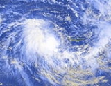
Tropical Storm Alex
Tropical Cyclone Alex began on 24 October 2001 when the Joint Typhoon Warning CenterJoint Typhoon Warning Center
The Joint Typhoon Warning Center is a joint United States Navy – United States Air Force task force located at the Naval Maritime Forecast Center in Pearl Harbor, Hawaii...
(JTWC) noted an area of convection
Convection
Convection is the movement of molecules within fluids and rheids. It cannot take place in solids, since neither bulk current flows nor significant diffusion can take place in solids....
developing southwest of Sumatra
Sumatra
Sumatra is an island in western Indonesia, westernmost of the Sunda Islands. It is the largest island entirely in Indonesia , and the sixth largest island in the world at 473,481 km2 with a population of 50,365,538...
and north of Cocos (Keeling) Islands
Cocos (Keeling) Islands
The Territory of the Cocos Islands, also called Cocos Islands and Keeling Islands, is a territory of Australia, located in the Indian Ocean, southwest of Christmas Island and approximately midway between Australia and Sri Lanka....
. On 25 October, the JTWC relocated the disturbance further west as it became better organised. The JTWC issued a Tropical Cyclone Formation Alert
Tropical Cyclone Formation Alert
A Tropical Cyclone Formation Alert is a bulletin released by the U.S. Navy-operated Joint Typhoon Warning Center in Honolulu, Hawaii or the Naval Maritime Forecast Center in Norfolk, Virginia, warning of the possibility of a tropical cyclone forming from a tropical disturbance that has been...
on the tropical low later that day. On 26 October, the Tropical Cyclone Warning Centre in Perth
Perth, Western Australia
Perth is the capital and largest city of the Australian state of Western Australia and the fourth most populous city in Australia. The Perth metropolitan area has an estimated population of almost 1,700,000....
issued a gale warning on the system, forecasting further development. Three hours later, TCWC Perth upgraded the low to Tropical Cyclone Alex 555 km (345 mi) northwest of Cocos (Keeling) Islands. The JTWC followed suit, upgrading the low to tropical cyclone status in its first advisory. It moved slowly westward while upper-level wind shear
Wind shear
Wind shear, sometimes referred to as windshear or wind gradient, is a difference in wind speed and direction over a relatively short distance in the atmosphere...
prevented the storm from intensifying. However, late on 27 October, the storm's deep convection had become better organised and Perth raised Alex's peak winds to 95 km/h (60 mph). Alex continued to move to the west-southwest, steered by a mid-level ridge
Ridge (meteorology)
A ridge is an elongated region of relatively high atmospheric pressure, the opposite of a trough....
to the southeast. Alex moved west of 90°E
90th meridian east
The meridian 90° east of Greenwich is a line of longitude that extends from the North Pole across the Arctic Ocean, Asia, the Indian Ocean, the Southern Ocean, and Antarctica to the South Pole.The Ninety East Ridge is named after the meridian....
into La Réunion
La Reunion
La Reunion may refer to:* La Reunion , a communal settlement near present-day Dallas, Texas*La Réunion, Lot-et-Garonne, a town in the Lot-et-Garonne department of France*Réunion, an island in the Indian Ocean east of Madagascar...
's area of responsibility early on 28 October and was renamed Severe Tropical Storm Andre by Mauritius
Mauritius
Mauritius , officially the Republic of Mauritius is an island nation off the southeast coast of the African continent in the southwest Indian Ocean, about east of Madagascar...
. Alex-Andre at this time reached its peak intensity, with Météo-France
Météo-France
Météo-France is the French national meteorological service.The organisation was established by decree in June 1993 and is a department of the Ministry of Transportation. It is headquartered in Paris but many domestic operations have been decentralised to Toulouse...
estimating 10-min sustained winds to be 55 kt, while the JTWC estimated 1-min sustained winds to be 55 kt as well; see 2001-02 South-West Indian Ocean cyclone season
2001-02 South-West Indian Ocean cyclone season
The 2001-02 South-West Indian Ocean cyclone season was an annual event of tropical cyclone formation. It started on November 15, 2001 and ended on April 30, 2002. For Mauritius and the Seychelles, the season continued until May 15. These dates conventionally delimit the period of each year when...
.
Tropical Low
A weak disturbance originated just west of TCWC Perth's area of responsibility about 625 nm west-northwest of Cocos IslandsCocos (Keeling) Islands
The Territory of the Cocos Islands, also called Cocos Islands and Keeling Islands, is a territory of Australia, located in the Indian Ocean, southwest of Christmas Island and approximately midway between Australia and Sri Lanka....
on 7 November. Over the next few days, it moved slowly east-southeastward towards Cocos. Perth issued gale warnings on the 10th in anticipation of tropical cyclone development. However, when the system failed to develop, the final warning was issued that day at 2200 UTC. Joint Typhoon Warning Center never issued warnings for the system, but did issue at Tropical Cyclone Formation Alert on 9 November. The Bureau of Meteorology continued mentioning the system in their Tropical Cyclone Outlooks. The system drifted back westward and was last mentioned on 13 November when it was about 500 nm from Cocos.
Tropical Cyclone 03S
A monsoon trough present near the equatorEquator
An equator is the intersection of a sphere's surface with the plane perpendicular to the sphere's axis of rotation and containing the sphere's center of mass....
spawned a low near eastern New Guinea
New Guinea
New Guinea is the world's second largest island, after Greenland, covering a land area of 786,000 km2. Located in the southwest Pacific Ocean, it lies geographically to the east of the Malay Archipelago, with which it is sometimes included as part of a greater Indo-Australian Archipelago...
. The system tracked westward at a very low latitude. Convection rapidly built around the system because of its position near the axis of the ridge and the low vertical wind shear in the environment. The storm was mentioned by TCWC Darwin in the daily Tropical Weather Outlook on 15 November and given a low to moderate chance of developing into a tropical cyclone within 72 hours. On 17 November, tropical depression formed near southern Papua New Guinea.
By the 19th conditions were less favourable, and the JTWC indicated that convection was sheared to the west of the well-defined, yet weak, circulation centre. Up to this point, Darwin and JTWC were in agreement regarding the system's strength and its potential for development. However, JTWC issued their first Tropical Cyclone Formation Alert on 21 November, placing the system's center about 200 nm east-northeast of Timor
Timor
Timor is an island at the southern end of Maritime Southeast Asia, north of the Timor Sea. It is divided between the independent state of East Timor, and West Timor, belonging to the Indonesian province of East Nusa Tenggara. The island's surface is 30,777 square kilometres...
. At 0600 UTC they upgraded the low to a weak tropical cyclone and issued their first warning. JTWC forecast slight strengthening which did not materialise. They issued their second and final warning at 1800 UTC. In their final best track, JTWC held the estimated tropical cyclone-strength intensity through the next day. Though the system was overland for some time, the damage it caused is unknown.
Tropical Cyclone Bessi
An area of convectionConvection
Convection is the movement of molecules within fluids and rheids. It cannot take place in solids, since neither bulk current flows nor significant diffusion can take place in solids....
developed on 25 November 2001 southwest of Sumatra
Sumatra
Sumatra is an island in western Indonesia, westernmost of the Sunda Islands. It is the largest island entirely in Indonesia , and the sixth largest island in the world at 473,481 km2 with a population of 50,365,538...
. The Joint Typhoon Warning Center
Joint Typhoon Warning Center
The Joint Typhoon Warning Center is a joint United States Navy – United States Air Force task force located at the Naval Maritime Forecast Center in Pearl Harbor, Hawaii...
(JTWC) issued a Tropical Cyclone Formation Alert
Tropical Cyclone Formation Alert
A Tropical Cyclone Formation Alert is a bulletin released by the U.S. Navy-operated Joint Typhoon Warning Center in Honolulu, Hawaii or the Naval Maritime Forecast Center in Norfolk, Virginia, warning of the possibility of a tropical cyclone forming from a tropical disturbance that has been...
(TCFA) on 26 November when the low continued to become better organised. At the same time, the Tropical Cyclone Warning Centre in Perth
Perth, Western Australia
Perth is the capital and largest city of the Australian state of Western Australia and the fourth most populous city in Australia. The Perth metropolitan area has an estimated population of almost 1,700,000....
began releasing gale warnings for the storm, anticipating further development. Moderate wind shear
Wind shear
Wind shear, sometimes referred to as windshear or wind gradient, is a difference in wind speed and direction over a relatively short distance in the atmosphere...
prevented the low from intensifying, which made it necessary for the JTWC to issue another TCFA on 27 November. Shortly after, the JTWC issued their first warning on the storm, designating it 05S, while Perth upgraded the cyclone to Tropical Cyclone Bessi. At this time, the cyclone was located about 650 km (400 mi) northwest of Cocos (Keeling) Islands
Cocos (Keeling) Islands
The Territory of the Cocos Islands, also called Cocos Islands and Keeling Islands, is a territory of Australia, located in the Indian Ocean, southwest of Christmas Island and approximately midway between Australia and Sri Lanka....
. Bessi was initially moving westwards, but turned to the south as a mid-level trough
Trough (meteorology)
A trough is an elongated region of relatively low atmospheric pressure, often associated with fronts.Unlike fronts, there is not a universal symbol for a trough on a weather chart. The weather charts in some countries or regions mark troughs by a line. In the United States, a trough may be marked...
weakened the subtropical ridge
Ridge (meteorology)
A ridge is an elongated region of relatively high atmospheric pressure, the opposite of a trough....
which was steering the cyclone westwards. Bessi reached its first peak intensity of 110 km/h (70 mph) on 28 November while located 695 km (430 mi) west-northwest of Cocos Islands. It weakened thereafter as it moved into an area of high vertical wind shear
Wind shear
Wind shear, sometimes referred to as windshear or wind gradient, is a difference in wind speed and direction over a relatively short distance in the atmosphere...
. Bessi moved to the south-southeast on 29 November, then curved to the west on 30 November while weakening to 75 km/h (45 mph). It moved west of 90°E
90th meridian east
The meridian 90° east of Greenwich is a line of longitude that extends from the North Pole across the Arctic Ocean, Asia, the Indian Ocean, the Southern Ocean, and Antarctica to the South Pole.The Ninety East Ridge is named after the meridian....
, entering La Réunion
La Reunion
La Reunion may refer to:* La Reunion , a communal settlement near present-day Dallas, Texas*La Réunion, Lot-et-Garonne, a town in the Lot-et-Garonne department of France*Réunion, an island in the Indian Ocean east of Madagascar...
's area of responsibility, and was renamed Tropical Storm Bako. Cyclone Bessi-Bako later reached its peak intensity of 65 knots as estimated by Météo-France
Météo-France
Météo-France is the French national meteorological service.The organisation was established by decree in June 1993 and is a department of the Ministry of Transportation. It is headquartered in Paris but many domestic operations have been decentralised to Toulouse...
; see 2001-02 South-West Indian Ocean cyclone season
2001-02 South-West Indian Ocean cyclone season
The 2001-02 South-West Indian Ocean cyclone season was an annual event of tropical cyclone formation. It started on November 15, 2001 and ended on April 30, 2002. For Mauritius and the Seychelles, the season continued until May 15. These dates conventionally delimit the period of each year when...
.
Tropical Cyclone Bernie
A weak tropical low developed in the Arafura SeaArafura Sea
The Arafura Sea lies west of the Pacific Ocean overlying the continental shelf between Australia and New Guinea.-Geography:The Arafura Sea is bordered by Torres Strait and through that the Coral Sea to the east, the Gulf of Carpentaria to the south, the Timor Sea to the west and the Banda and Ceram...
northeast of Nhulunbuy, Northern Territory
Nhulunbuy, Northern Territory
Nhulunbuy is the name of the township created on the Gove Peninsula in the Northern Territory of Australia when a bauxite mine and deep water port were established nearby in the late 1960s...
on 1 January 2002. It moved slowly to the south into the Gulf of Carpentaria
Gulf of Carpentaria
The Gulf of Carpentaria is a large, shallow sea enclosed on three sides by northern Australia and bounded on the north by the Arafura Sea...
and intensified to Tropical Cyclone Bernie on 3 January. It peaked in intensity early the next day as a Category 2 cyclone, with wind gusts reaching 130 km/h (80 mph). Bernie was moving to the southwest and started to weaken, before crossing the coast near the borderline between Queensland
Queensland
Queensland is a state of Australia, occupying the north-eastern section of the mainland continent. It is bordered by the Northern Territory, South Australia and New South Wales to the west, south-west and south respectively. To the east, Queensland is bordered by the Coral Sea and Pacific Ocean...
and Northern Territory
Northern Territory
The Northern Territory is a federal territory of Australia, occupying much of the centre of the mainland continent, as well as the central northern regions...
early on 5 January as a Category 1 cyclone. It weakened to a rain depression shortly after and continued to move southwards into the Barkly district on 6 January.
Early on 4 January, Bernie was close to making landfall over Mornington Island
Mornington Island
Mornington Island is the northern most of 22 islands that form the Wellesley Islands group. The island is located in the Gulf of Carpentaria at and is part of the Gulf Country region in the Australian state of Queensland. The Manowar and Rocky Islands Important Bird Area lies about 40 km to...
, and cyclone warnings were declared between the Northern Territory border and Kowanyama
Kowanyama, Queensland
Kowanyama is a town on the Gulf of Carpentaria side of Cape York Peninsula in Far North Queensland, Australia.At the 2006 census, Kowanyama had a population of 1,017....
in Queensland. However, the cyclone warnings were shifted to the west later in the day for areas between Port McArthur in the Northern Territory and the Gilbert-Einasleigh River
Gilbert-Einasleigh River
The Gilbert-Einasleigh River is one of the largest river systems in northern Australia. It is located in north-central Queensland, between the Flinders River and the Mitchell River.-Description:...
mouth in Queensland. As the cyclone neared the island, many residents in Mornington Island were moved to a more secure shelter. A few hours later, residents between Port McArthur and Karumba, Queensland
Karumba, Queensland
Karumba is a town in the Gulf Country region of Queensland, Australia, 71 km by road from Normanton and 2159 km from the state capital, Brisbane. The settlement was previously known as Norman Mouth and Kimberely. Karumba was used by the local aborigines to describe the place...
were warned of a dangerous storm surge
Storm surge
A storm surge is an offshore rise of water associated with a low pressure weather system, typically tropical cyclones and strong extratropical cyclones. Storm surges are caused primarily by high winds pushing on the ocean's surface. The wind causes the water to pile up higher than the ordinary sea...
associated with Bernie.
Mornington Island recorded more than 300 mm (12 in) of precipitation in a 24 hour period and experienced gusts of 100 km/h (60 mph). A few houses in the island lost power. However, only light damages occurred, and there were no casualties on the island. The town of Karumba also experienced heavy damage, with the storm surge damaging the beach. The towns Burketown
Burketown, Queensland
- Morning glory cloud :From the months of August to November, a rare meteorological phenomenon known as "Morning Glory" - long, tubular clouds, some up to 1000 km in length - is often observed in the skies above Burketown.....
and Doomadgee
Doomadgee, Queensland
Doomadgee Aboriginal Mission, originally known as Dumaji, was located on Bayley Point on the Gulf of Carpentaria. In 1936 after being destroyed by a cyclone the community was relocated to Nicholson River...
in Queensland were isolated for two weeks due to flooded roads.
Pastoralists in the Gulf country were anticipating high rainfall from Bernie, but only received low rainfall. Further south in Roma, Queensland
Roma, Queensland
Roma is a town in the western Darling Downs area of Queensland, Australia, by rail WNW of Brisbane. It is situated at the junction of the Warrego and Carnarvon highways...
, the rains helped lift up the prices in the cattle market. People in inland areas of the Gulf country were hit by bushfires in November and December 2001 and were anticipating the arrival of Bernie, hoping that it will bring rain to extinguish the fires. However, Bernie delivered very little rain to the area.
Severe Tropical Cyclone Chris
Severe Tropical Cyclone Chris developed on 2 February off the north Western AustraliaWestern Australia
Western Australia is a state of Australia, occupying the entire western third of the Australian continent. It is bounded by the Indian Ocean to the north and west, the Great Australian Bight and Indian Ocean to the south, the Northern Territory to the north-east and South Australia to the south-east...
coast. The storm peaked with 230 km/h (145 mph) winds before making landfall to the east of Port Hedland, Western Australia
Port Hedland, Western Australia
Port Hedland is the highest tonnage port in Australia and largest town in the Pilbara region of Western Australia, with a population of approximately 14,000 ....
and dissipated overland on 6 February. Chris was responsible for some inland flooding.
Northern Territory Monsoon Low
By 9 February a monsoon low had formed inland about 220 kilometers southwest of DarwinDarwin, Northern Territory
Darwin is the capital city of the Northern Territory, Australia. Situated on the Timor Sea, Darwin has a population of 127,500, making it by far the largest and most populated city in the sparsely populated Northern Territory, but the least populous of all Australia's capital cities...
. This system drifted eastward over land, reaching the shoreline on the Gulf of Carpentaria on the 13 February. TCWC Darwin anticipated tropical cyclone development for the system, and had issued Tropical Cyclone Advices for this system on the 12th and 13th. However, development failed to materialize.
The monsoon low in conjunction with the active trough over Northern Territory produced floods in several of the area's river systems. Major flooding in the Wickham River tributary caused moderate flooding in the Victoria River. The Waterhouse River began rising on the 12th, forcing 500 people to evacuate. Katherine
Katherine, Northern Territory
Katherine is a town situated southeast of Darwin in the "Top End" of Australia in the Northern Territory. It is the fourth largest settlement in the Territory after the capital Darwin, Palmerston and Alice Springs...
was threatened, but did not flood when the Katherine River
Katherine River
Katherine River is located in the Northern Territory, Australia. Its headwaters are in Nitmiluk National Park, it flows through the town of Katherine, and is a major tributary of the Daly River....
rose to a peak of 17.03 metres on the 14th.
Monsoon Low
A tropical low formed in the southern Gulf of CarpentariaGulf of Carpentaria
The Gulf of Carpentaria is a large, shallow sea enclosed on three sides by northern Australia and bounded on the north by the Arafura Sea...
on 16 February east-northeast of Mornington Island
Mornington Island
Mornington Island is the northern most of 22 islands that form the Wellesley Islands group. The island is located in the Gulf of Carpentaria at and is part of the Gulf Country region in the Australian state of Queensland. The Manowar and Rocky Islands Important Bird Area lies about 40 km to...
. The low moved westwards and made landfall in the Northern Territory
Northern Territory
The Northern Territory is a federal territory of Australia, occupying much of the centre of the mainland continent, as well as the central northern regions...
the next day. Tropical Cyclone Warning Centre in Darwin
Darwin, Northern Territory
Darwin is the capital city of the Northern Territory, Australia. Situated on the Timor Sea, Darwin has a population of 127,500, making it by far the largest and most populated city in the sparsely populated Northern Territory, but the least populous of all Australia's capital cities...
continued to track the monsoon low as it moved slowly westward across the southern portion of the territory. On 21 February, the Tropical Cyclone Warning Centre in Perth
Perth, Western Australia
Perth is the capital and largest city of the Australian state of Western Australia and the fourth most populous city in Australia. The Perth metropolitan area has an estimated population of almost 1,700,000....
began referring to a low in the Kimberley region of Western Australia
Western Australia
Western Australia is a state of Australia, occupying the entire western third of the Australian continent. It is bounded by the Indian Ocean to the north and west, the Great Australian Bight and Indian Ocean to the south, the Northern Territory to the north-east and South Australia to the south-east...
640 km (400 mi) southwest of Darwin. It is likely that this low was a continuation of the low that formed in the Gulf of Carpentaria, though TCWC Perth did not explicitly state this. The low remained inland as it continued to move westwards into the eastern Pilbara and finally dissipated on 28 February.
Heavy rainfall caused the water level in the Fitzroy River
Fitzroy River (Western Australia)
The Fitzroy River is located in the West Kimberley region of Western Australia.-Discovery:The Fitzroy River was discovered by the West in 1837 by George Grey in the H.M.S. Beagle. The river was subsequently named by Lt J L Stokes on 26/2/1838 after Captain Robert FitzRoy R.N...
to rise to near record levels, with daily rainfall totals exceeding 100 mm. Many towns and communities, including Kununurra
Kununurra, Western Australia
Kununurra is a town in far northern Western Australia located at the eastern extremity of the Kimberley Region approximately from the border with the Northern Territory. Kununurra was initiated to service the Ord River Irrigation scheme....
, were isolated by floodwaters, and several Aboriginal communities were evacuated. Significant stock losses occurred in the area. Bonney Downs in the Pilbara recorded a daily rainfall total of 229 mm on 27 February.
Severe Tropical Cyclone Claudia
The origins of Claudia came from an area of convectionConvection
Convection is the movement of molecules within fluids and rheids. It cannot take place in solids, since neither bulk current flows nor significant diffusion can take place in solids....
which formed 1020 km (635 mi) east-southeast of Port Moresby
Port Moresby
Port Moresby , or Pot Mosbi in Tok Pisin, is the capital and largest city of Papua New Guinea . It is located on the shores of the Gulf of Papua, on the southeastern coast of the island of New Guinea, which made it a prime objective for conquest by the Imperial Japanese forces during 1942–43...
, Papua New Guinea
Papua New Guinea
Papua New Guinea , officially the Independent State of Papua New Guinea, is a country in Oceania, occupying the eastern half of the island of New Guinea and numerous offshore islands...
on 9 February 2002. The system did not develop further until on 11 February where it began to develop rapidly. The Tropical Cyclone Warning Centre (TCWC) in Brisbane
Brisbane
Brisbane is the capital and most populous city in the Australian state of Queensland and the third most populous city in Australia. Brisbane's metropolitan area has a population of over 2 million, and the South East Queensland urban conurbation, centred around Brisbane, encompasses a population of...
identified the storm as a tropical low 990 km (615 mi) east of Townsville, Queensland
Townsville, Queensland
Townsville is a city on the north-eastern coast of Australia, in the state of Queensland. Adjacent to the central section of the Great Barrier Reef, it is in the dry tropics region of Queensland. Townsville is Australia's largest urban centre north of the Sunshine Coast, with a 2006 census...
, while the Joint Typhoon Warning Center
Joint Typhoon Warning Center
The Joint Typhoon Warning Center is a joint United States Navy – United States Air Force task force located at the Naval Maritime Forecast Center in Pearl Harbor, Hawaii...
(JTWC) issued a Tropical Cyclone Formation Alert
Tropical Cyclone Formation Alert
A Tropical Cyclone Formation Alert is a bulletin released by the U.S. Navy-operated Joint Typhoon Warning Center in Honolulu, Hawaii or the Naval Maritime Forecast Center in Norfolk, Virginia, warning of the possibility of a tropical cyclone forming from a tropical disturbance that has been...
for the system. A couple hours later, the low was upgraded to Tropical Cyclone Claudia by TCWC Brisbane, while the JTWC also upgraded the storm to tropical cyclone status, designating it as Tropical Cyclone 14P. Later that day, the JTWC upped Claudia's peak winds to 120 km/h (75 mph), after a well-defined eye
Eye (cyclone)
The eye is a region of mostly calm weather found at the center of strong tropical cyclones. The eye of a storm is a roughly circular area and typically 30–65 km in diameter. It is surrounded by the eyewall, a ring of towering thunderstorms where the second most severe weather of a cyclone...
was spotted in infrared imagery. The very small cyclone was moving southeastwards and continued to rapidly intensify
Rapid deepening
Rapid deepening, also known as rapid intensification, is a meteorological condition that occurs when the minimum sea-level atmospheric pressure of a tropical cyclone decreases drastically in a short period of time. The National Weather Service describes rapid deepening as a decrease of...
due to good outflow
Outflow (meteorology)
Outflow, in meteorology, is air that flows outwards from a storm system. It is associated with ridging, or anticyclonic flow. In the low levels of the troposphere, outflow radiates from thunderstorms in the form of a wedge of rain-cooled air, which is visible as a thin rope-like cloud on weather...
. Early on 12 February, TCWC Brisbane upgraded Claudia to a Category 3 severe tropical cyclone, with estimated peak winds of 120 km/h (75 mph), while the JTWC estimated peak winds of 140 km/h (85 mph). Claudia was moving quickly to the southeast towards Fiji
Fiji
Fiji , officially the Republic of Fiji , is an island nation in Melanesia in the South Pacific Ocean about northeast of New Zealand's North Island...
's area of responsibility and TCWC Brisbane its last warning for Claudia later that day when it moved east of 160°E
160th meridian east
The meridian 160° east of Greenwich is a line of longitude that extends from the North Pole across the Arctic Ocean, Asia, the Pacific Ocean, the Southern Ocean, and Antarctica to the South Pole....
out of TCWC Brisbane's area of responsibility; see 2001-02 South Pacific cyclone season
2001-02 South Pacific cyclone season
The 2001–02 South Pacific cyclone season was a below-average year in which only five named storms formed or entered the South Pacific basin. It began on 1 November 2001 and ended on 30 April 2002. These dates conventionally delimit the period of each year when most tropical cyclones form in the...
.
Tropical Cyclone Des
Tropical Cyclone Des originated from an area of convectionConvection
Convection is the movement of molecules within fluids and rheids. It cannot take place in solids, since neither bulk current flows nor significant diffusion can take place in solids....
which formed on 3 March 835 km (520 mi) east-southeast of Port Moresby
Port Moresby
Port Moresby , or Pot Mosbi in Tok Pisin, is the capital and largest city of Papua New Guinea . It is located on the shores of the Gulf of Papua, on the southeastern coast of the island of New Guinea, which made it a prime objective for conquest by the Imperial Japanese forces during 1942–43...
, Papua New Guinea
Papua New Guinea
Papua New Guinea , officially the Independent State of Papua New Guinea, is a country in Oceania, occupying the eastern half of the island of New Guinea and numerous offshore islands...
. Late on 4 March, the Tropical Cyclone Warning Centre (TCWC) in Brisbane
Brisbane
Brisbane is the capital and most populous city in the Australian state of Queensland and the third most populous city in Australia. Brisbane's metropolitan area has a population of over 2 million, and the South East Queensland urban conurbation, centred around Brisbane, encompasses a population of...
initiated warnings for the tropical low as the system's convection deepened. The Joint Typhoon Warning Center
Joint Typhoon Warning Center
The Joint Typhoon Warning Center is a joint United States Navy – United States Air Force task force located at the Naval Maritime Forecast Center in Pearl Harbor, Hawaii...
(JTWC) issued a Tropical Cyclone Formation Alert for the storm, and later upgraded it to Tropical Cyclone 17P at 0600 UTC
Coordinated Universal Time
Coordinated Universal Time is the primary time standard by which the world regulates clocks and time. It is one of several closely related successors to Greenwich Mean Time. Computer servers, online services and other entities that rely on having a universally accepted time use UTC for that purpose...
on 5 March. The cyclone was moving to the east-southeast, steered by a low to mid-level ridge
Ridge (meteorology)
A ridge is an elongated region of relatively high atmospheric pressure, the opposite of a trough....
east of the storm. Favourable conditions and good outflow
Outflow (meteorology)
Outflow, in meteorology, is air that flows outwards from a storm system. It is associated with ridging, or anticyclonic flow. In the low levels of the troposphere, outflow radiates from thunderstorms in the form of a wedge of rain-cooled air, which is visible as a thin rope-like cloud on weather...
enabled the cyclone to strengthen, and TCWC Brisbane upgraded it to Tropical Cyclone Des at 0900 UTC on the same day with peak winds of 75 km/h (45 mph). At the time of upgrade, Des was located only 55 km (35 mi) west of 160°E
160th meridian east
The meridian 160° east of Greenwich is a line of longitude that extends from the North Pole across the Arctic Ocean, Asia, the Pacific Ocean, the Southern Ocean, and Antarctica to the South Pole....
, near the border between Brisbane's and Nadi's respective areas of responsibility. Warnings were issued by RSMC Nadi thereafter as the cyclone continued to move to the southeast; see 2001-02 South Pacific cyclone season
2001-02 South Pacific cyclone season
The 2001–02 South Pacific cyclone season was a below-average year in which only five named storms formed or entered the South Pacific basin. It began on 1 November 2001 and ended on 30 April 2002. These dates conventionally delimit the period of each year when most tropical cyclones form in the...
.
Severe Tropical Cyclone Dianne
Cyclone Dianne formed after a long period of cyclone inactivity off northwestern Australia and in the Southeast Indian Ocean since Cyclone Chris in early February. On 4 April 2002 an area of convectionConvection
Convection is the movement of molecules within fluids and rheids. It cannot take place in solids, since neither bulk current flows nor significant diffusion can take place in solids....
developed 350 km (220 mi) northeast of Cocos (Keeling) Islands
Cocos (Keeling) Islands
The Territory of the Cocos Islands, also called Cocos Islands and Keeling Islands, is a territory of Australia, located in the Indian Ocean, southwest of Christmas Island and approximately midway between Australia and Sri Lanka....
. The system intensified under favourable conditions and outflow
Outflow (meteorology)
Outflow, in meteorology, is air that flows outwards from a storm system. It is associated with ridging, or anticyclonic flow. In the low levels of the troposphere, outflow radiates from thunderstorms in the form of a wedge of rain-cooled air, which is visible as a thin rope-like cloud on weather...
improved over the storm. The Joint Typhoon Warning Center
Joint Typhoon Warning Center
The Joint Typhoon Warning Center is a joint United States Navy – United States Air Force task force located at the Naval Maritime Forecast Center in Pearl Harbor, Hawaii...
(JTWC) issued a Tropical Cyclone Formation Alert
Tropical Cyclone Formation Alert
A Tropical Cyclone Formation Alert is a bulletin released by the U.S. Navy-operated Joint Typhoon Warning Center in Honolulu, Hawaii or the Naval Maritime Forecast Center in Norfolk, Virginia, warning of the possibility of a tropical cyclone forming from a tropical disturbance that has been...
on 6 April for the system, and upgraded to Tropical Cyclone 21S on 7 April, when convection deepened rapidly over the storm. It moved west-southwestward, influenced by a mid-level ridge which extended from the Australia
Australia
Australia , officially the Commonwealth of Australia, is a country in the Southern Hemisphere comprising the mainland of the Australian continent, the island of Tasmania, and numerous smaller islands in the Indian and Pacific Oceans. It is the world's sixth-largest country by total area...
n west coast. As the cyclone edged closer to the Cocos Islands, a cyclone warning was issued by the Tropical Cyclone Warning Centre in Perth
Perth, Western Australia
Perth is the capital and largest city of the Australian state of Western Australia and the fourth most populous city in Australia. The Perth metropolitan area has an estimated population of almost 1,700,000....
for possible gale force winds developing over the islands. TCWC Perth issued its first gale warning for the developing cyclone at 0300 UTC
Coordinated Universal Time
Coordinated Universal Time is the primary time standard by which the world regulates clocks and time. It is one of several closely related successors to Greenwich Mean Time. Computer servers, online services and other entities that rely on having a universally accepted time use UTC for that purpose...
on 7 April, and upgraded it to Tropical Cyclone Dianne just two hours later with peak winds of 85 km/h (50 mph). Although Dianne passed about 30 km south of the islands, no gale force winds were reported there. Dianne moved away from the Cocos Islands, and intensified further, developing a banding eye
Eye (cyclone)
The eye is a region of mostly calm weather found at the center of strong tropical cyclones. The eye of a storm is a roughly circular area and typically 30–65 km in diameter. It is surrounded by the eyewall, a ring of towering thunderstorms where the second most severe weather of a cyclone...
feature. Early on 8 April, the JTWC upgraded Dianne from tropical storm to tropical cyclone status with peak winds of 120 km/h (75 mph), equivalent to a minimal hurricane. Later that day, TCWC Perth followed suit, upgrading Dianne to a Category 3 severe tropical cyclone with peak winds of 140 km/h (85 mph). Dianne continued moving to the west-southwest and crossed the boundary at 90°E
90th meridian east
The meridian 90° east of Greenwich is a line of longitude that extends from the North Pole across the Arctic Ocean, Asia, the Indian Ocean, the Southern Ocean, and Antarctica to the South Pole.The Ninety East Ridge is named after the meridian....
into La Réunion
La Reunion
La Reunion may refer to:* La Reunion , a communal settlement near present-day Dallas, Texas*La Réunion, Lot-et-Garonne, a town in the Lot-et-Garonne department of France*Réunion, an island in the Indian Ocean east of Madagascar...
's area of responsibility and was renamed Tropical Cyclone Jery by the Mauritius Meteorological Service; see 2001-02 South-West Indian Ocean cyclone season
2001-02 South-West Indian Ocean cyclone season
The 2001-02 South-West Indian Ocean cyclone season was an annual event of tropical cyclone formation. It started on November 15, 2001 and ended on April 30, 2002. For Mauritius and the Seychelles, the season continued until May 15. These dates conventionally delimit the period of each year when...
.
Tropical Cyclone Bonnie
An area of convectionConvection
Convection is the movement of molecules within fluids and rheids. It cannot take place in solids, since neither bulk current flows nor significant diffusion can take place in solids....
formed 600 km (375 mi) northeast of Darwin, Northern Territory
Darwin, Northern Territory
Darwin is the capital city of the Northern Territory, Australia. Situated on the Timor Sea, Darwin has a population of 127,500, making it by far the largest and most populated city in the sparsely populated Northern Territory, but the least populous of all Australia's capital cities...
on 7 April. An increase in deep convection occurred late on 9 April, with the Joint Typhoon Warning Center
Joint Typhoon Warning Center
The Joint Typhoon Warning Center is a joint United States Navy – United States Air Force task force located at the Naval Maritime Forecast Center in Pearl Harbor, Hawaii...
(JTWC) issuing a Tropical Cyclone Formation Alert
Tropical Cyclone Formation Alert
A Tropical Cyclone Formation Alert is a bulletin released by the U.S. Navy-operated Joint Typhoon Warning Center in Honolulu, Hawaii or the Naval Maritime Forecast Center in Norfolk, Virginia, warning of the possibility of a tropical cyclone forming from a tropical disturbance that has been...
for the developing system. At this time, the Tropical Cyclone Warning Centre (TCWC) in Darwin initiated gale warnings for the tropical low, but it was upgraded to Tropical Cyclone Bonnie six hours later, 240 km (150 mi) east of Timor
Timor
Timor is an island at the southern end of Maritime Southeast Asia, north of the Timor Sea. It is divided between the independent state of East Timor, and West Timor, belonging to the Indonesian province of East Nusa Tenggara. The island's surface is 30,777 square kilometres...
. Bonnie was moving west-southwestwards andmade landfall
Landfall (meteorology)
Landfall is the event of a tropical cyclone or a waterspout coming onto land after being over water. When a waterspout makes landfall it is reclassified as a tornado, which can then cause damage inland...
on the Timorese coast on 10 April. The cyclone entered TCWC Perth
Perth, Western Australia
Perth is the capital and largest city of the Australian state of Western Australia and the fourth most populous city in Australia. The Perth metropolitan area has an estimated population of almost 1,700,000....
's area of warning responsibility as it moved west of 125°E
125th meridian east
The meridian 125° east of Greenwich is a line of longitude that extends from the North Pole across the Arctic Ocean, Asia, Australia, the Indian Ocean, the Southern Ocean, and Antarctica to the South Pole....
. Land interaction inhibited the storm from developing, but the cyclone later moved into the Savu Sea
Savu Sea
The Savu Sea is a small sea within Indonesia named for the island of Savu on its southern boundary. It is bounded by Savu and Rai Jua to the south, the islands of Rote and Timor to the east, Flores and the Alor archipelago to the north/northwest, and the island of Sumba to the west/northwest...
where good outflow
Outflow (meteorology)
Outflow, in meteorology, is air that flows outwards from a storm system. It is associated with ridging, or anticyclonic flow. In the low levels of the troposphere, outflow radiates from thunderstorms in the form of a wedge of rain-cooled air, which is visible as a thin rope-like cloud on weather...
enabled the storm to strengthen. Bonnie later moved over the south coast of Sumba
Sumba
Sumba is an island in eastern Indonesia, is one of the Lesser Sunda Islands, and is in the province of East Nusa Tenggara. Sumba has an area of 11,153 km², and the population was officially at 611,422 in 2005...
on 11 April where the land mass weakened the storm again. After moving over water for the second time on 12 April, TCWC Perth and the JTWC increased Bonnie's peak winds to 95 km/h (60 mph). Bonnie continued to move west-southwestwards but the storm began to slowly weaken as its deep convection decreased and interacted with the island of Java
Java
Java is an island of Indonesia. With a population of 135 million , it is the world's most populous island, and one of the most densely populated regions in the world. It is home to 60% of Indonesia's population. The Indonesian capital city, Jakarta, is in west Java...
. TCWC Perth issued its last gale warning on Bonnie late on 14 April. The JTWC continued to issue advisories on the low until late on 15 April 465 km (290 mi) south-southeast of Cocos (Keeling) Islands
Cocos (Keeling) Islands
The Territory of the Cocos Islands, also called Cocos Islands and Keeling Islands, is a territory of Australia, located in the Indian Ocean, southwest of Christmas Island and approximately midway between Australia and Sri Lanka....
.
Bonnie caused heavy rainfall and gusty winds in Timor and Sumba. Flash flooding in Sumba killed 19 people. Bonnie also caused a moist northeast wind flow that triggered above average rainfall to northern Western Australia
Western Australia
Western Australia is a state of Australia, occupying the entire western third of the Australian continent. It is bounded by the Indian Ocean to the north and west, the Great Australian Bight and Indian Ocean to the south, the Northern Territory to the north-east and South Australia to the south-east...
.
Tropical Cyclone Errol
Tropical Cyclone Errol was a late season storm that attained tropical cyclone on 9 May 2002. It did not last long, and weakened early on 10 May, located about 600 km north of Cocos (Keeling) IslandsCocos (Keeling) Islands
The Territory of the Cocos Islands, also called Cocos Islands and Keeling Islands, is a territory of Australia, located in the Indian Ocean, southwest of Christmas Island and approximately midway between Australia and Sri Lanka....
. Errol was operationally tracked as maintaining tropical cyclone intensity until 14 May, however post-analysis indicated that the cyclone's winds were below gale force, therefore, it was not a tropical cyclone during this time. The remaining tropical low passed just east of Cocos Islands on 15 May.
Tropical Cyclone Upia
On 23 May a mass of convection north of Bougainville IslandBougainville Island
Bougainville Island is the main island of the Autonomous Region of Bougainville of Papua New Guinea. This region is also known as Bougainville Province or the North Solomons. The population of the province is 175,160 , which includes the adjacent island of Buka and assorted outlying islands...
developed a well-defined mid-level circulation and broad low-level circulation. The center remained partially exposed for two more days until JTWC issued a Tropical Cyclone Formation Alert, placing the center about 100 nm south of the island. On 25 May, the storm was upgraded by the unofficial agency to Tropical Cyclone 25P. The waters around Papua New Guinea were part of the limited area of responsibility of TCWC Port Moresby
Port Moresby
Port Moresby , or Pot Mosbi in Tok Pisin, is the capital and largest city of Papua New Guinea . It is located on the shores of the Gulf of Papua, on the southeastern coast of the island of New Guinea, which made it a prime objective for conquest by the Imperial Japanese forces during 1942–43...
. When the cyclone was located near Eastern Milne Bay Province
Milne Bay Province
Milne Bay is a province of Papua New Guinea. Its capital is Alotau. The province covers 14,000 km² of land and 252,990 km² of sea, within the province there are more than 600 islands, about 160 of which are inhabited...
they named the tropical cyclone Upia. Upia was the first system named by the TCWC at Port Moresby since Tropical Cyclone Adel in May 1993.
That night and into the early hours of the 27th, the storm caused havoc on Budibudi Island. All coconut trees
Coconut
The coconut palm, Cocos nucifera, is a member of the family Arecaceae . It is the only accepted species in the genus Cocos. The term coconut can refer to the entire coconut palm, the seed, or the fruit, which is not a botanical nut. The spelling cocoanut is an old-fashioned form of the word...
- including those on adjacent islands - were flattened. Food crops on a nearby island used for agriculture were ruined by the surges. Several buildings were destroyed by Upia, although no fatalities were reported. The cyclone remained quasi-stationary for many hours until it began drifting south-southeastward. Port Moresby increased their intensity estimates for the system, reporting peak winds at 65 km/h (40 mph) while JTWC estimated the system was considerably weaker. On 28 May JTWC issued their final warning on the system. Port Moresby issued their last warning that day as well. The system was downgraded to an ex-tropical cyclone by TCWC Brisbane when it drifted toward their region.
Storm names
Tropical cyclones are assigned names by the Australian Bureau of Meteorology or Papua New GuineaPapua New Guinea
Papua New Guinea , officially the Independent State of Papua New Guinea, is a country in Oceania, occupying the eastern half of the island of New Guinea and numerous offshore islands...
.
Tropical cyclones are named if they are non-frontal low pressure systems of synoptic scale
Synoptic scale meteorology
The synoptic scale in meteorology is a horizontal length scale of the order of 1000 kilometres or more. This corresponds to a horizontal scale typical of mid-latitude depressions...
developing over warm waters, or Dvorak
Dvorak technique
The Dvorak technique is a widely used system to subjectively estimate tropical cyclone intensity based solely on visible and infrared satellite images. Several agencies issue Dvorak intensity numbers for cyclones of sufficient intensity...
intensity analysis indicate the presence of gale force
Beaufort scale
The Beaufort Scale is an empirical measure that relates wind speed to observed conditions at sea or on land. Its full name is the Beaufort Wind Force Scale.-History:...
or stronger winds near the centre. Therefore, a tropical system with gales in one or more quadrants, but not near the centre, are not named.
All names assigned in the Australian region are used sequentially, unlike lists used annually by the National Hurricane Centre in the Atlantic Ocean
Atlantic Ocean
The Atlantic Ocean is the second-largest of the world's oceanic divisions. With a total area of about , it covers approximately 20% of the Earth's surface and about 26% of its water surface area...
and east Pacific Ocean
Pacific Ocean
The Pacific Ocean is the largest of the Earth's oceanic divisions. It extends from the Arctic in the north to the Southern Ocean in the south, bounded by Asia and Australia in the west, and the Americas in the east.At 165.2 million square kilometres in area, this largest division of the World...
. Only the names used during this cyclone season are listed below. The complete list of names for each basin are found in the World Meteorological Organization
World Meteorological Organization
The World Meteorological Organization is an intergovernmental organization with a membership of 189 Member States and Territories. It originated from the International Meteorological Organization , which was founded in 1873...
's official list.
Southeast Indian Ocean
Tropical cyclones that develop east of 90°E90th meridian east
The meridian 90° east of Greenwich is a line of longitude that extends from the North Pole across the Arctic Ocean, Asia, the Indian Ocean, the Southern Ocean, and Antarctica to the South Pole.The Ninety East Ridge is named after the meridian....
, south of the Equator
Equator
An equator is the intersection of a sphere's surface with the plane perpendicular to the sphere's axis of rotation and containing the sphere's center of mass....
, and west of 125°E
125th meridian east
The meridian 125° east of Greenwich is a line of longitude that extends from the North Pole across the Arctic Ocean, Asia, Australia, the Indian Ocean, the Southern Ocean, and Antarctica to the South Pole....
are assigned names by the Tropical Cyclone Warning Centre in Perth
Perth, Western Australia
Perth is the capital and largest city of the Australian state of Western Australia and the fourth most populous city in Australia. The Perth metropolitan area has an estimated population of almost 1,700,000....
, Western Australia
Western Australia
Western Australia is a state of Australia, occupying the entire western third of the Australian continent. It is bounded by the Indian Ocean to the north and west, the Great Australian Bight and Indian Ocean to the south, the Northern Territory to the north-east and South Australia to the south-east...
. The name Chris was retired after its usage.
- Alex
- Bessi
- Chris
- Dianne
- Errol
Arafura Sea and Western Gulf of Carpentaria
Tropical cyclones that develop south of the Equator between 125°E125th meridian east
The meridian 125° east of Greenwich is a line of longitude that extends from the North Pole across the Arctic Ocean, Asia, Australia, the Indian Ocean, the Southern Ocean, and Antarctica to the South Pole....
and 141°E
141st meridian east
The 141st meridian east of Greenwich is a line of longitude that extends extends from the North Pole across the Arctic Ocean, Asia, the Pacific Ocean, Australasia, the Indian Ocean, the Southern Ocean, and Antarctica to the South Pole....
are assigned names by the Tropical Cyclone Warning Centre in Darwin
Darwin, Northern Territory
Darwin is the capital city of the Northern Territory, Australia. Situated on the Timor Sea, Darwin has a population of 127,500, making it by far the largest and most populated city in the sparsely populated Northern Territory, but the least populous of all Australia's capital cities...
, Northern Territory
Northern Territory
The Northern Territory is a federal territory of Australia, occupying much of the centre of the mainland continent, as well as the central northern regions...
.
- Bonnie
Coral Sea and Eastern Gulf of Carpentaria
Tropical cyclones that develop south of 10°S10th parallel south
The 10th parallel south is a circle of latitude that is 10 degrees south of the Earth's equatorial plane. It crosses the Atlantic Ocean, Africa, the Indian Ocean, Australasia, the Pacific Ocean and South America....
between 141°E
141st meridian east
The 141st meridian east of Greenwich is a line of longitude that extends extends from the North Pole across the Arctic Ocean, Asia, the Pacific Ocean, Australasia, the Indian Ocean, the Southern Ocean, and Antarctica to the South Pole....
and 160°E
160th meridian east
The meridian 160° east of Greenwich is a line of longitude that extends from the North Pole across the Arctic Ocean, Asia, the Pacific Ocean, the Southern Ocean, and Antarctica to the South Pole....
are assigned names by the Tropical Cyclone Warning Centre in Brisbane
Brisbane
Brisbane is the capital and most populous city in the Australian state of Queensland and the third most populous city in Australia. Brisbane's metropolitan area has a population of over 2 million, and the South East Queensland urban conurbation, centred around Brisbane, encompasses a population of...
, Queensland
Queensland
Queensland is a state of Australia, occupying the north-eastern section of the mainland continent. It is bordered by the Northern Territory, South Australia and New South Wales to the west, south-west and south respectively. To the east, Queensland is bordered by the Coral Sea and Pacific Ocean...
.
- Bernie
- Claudia
- Des
Solomon Sea and Gulf of Papua
Tropical cyclones that develop north of 10°S10th parallel south
The 10th parallel south is a circle of latitude that is 10 degrees south of the Earth's equatorial plane. It crosses the Atlantic Ocean, Africa, the Indian Ocean, Australasia, the Pacific Ocean and South America....
between 141°E
141st meridian east
The 141st meridian east of Greenwich is a line of longitude that extends extends from the North Pole across the Arctic Ocean, Asia, the Pacific Ocean, Australasia, the Indian Ocean, the Southern Ocean, and Antarctica to the South Pole....
and 160°E
160th meridian east
The meridian 160° east of Greenwich is a line of longitude that extends from the North Pole across the Arctic Ocean, Asia, the Pacific Ocean, the Southern Ocean, and Antarctica to the South Pole....
are assigned names by the Tropical Cyclone Warning Centre in Port Moresby
Port Moresby
Port Moresby , or Pot Mosbi in Tok Pisin, is the capital and largest city of Papua New Guinea . It is located on the shores of the Gulf of Papua, on the southeastern coast of the island of New Guinea, which made it a prime objective for conquest by the Imperial Japanese forces during 1942–43...
, Papua New Guinea
Papua New Guinea
Papua New Guinea , officially the Independent State of Papua New Guinea, is a country in Oceania, occupying the eastern half of the island of New Guinea and numerous offshore islands...
.
- Upia
See also
- List of Southern Hemisphere tropical cyclone seasons
- Atlantic hurricane seasons: 20012001 Atlantic hurricane seasonThe 2001 Atlantic hurricane season was a fairly active Atlantic hurricane season that produced 17 tropical cyclones, 15 named storms, nine hurricanes, and four major hurricanes. The season officially lasted from June 1, 2001, to November 30, 2001, dates which by convention limit the period of each...
, 20022002 Atlantic hurricane seasonThe 2002 Atlantic hurricane season was an average Atlantic hurricane season, officially starting on June 1, 2002 and ending on November 30, dates which conventionally limit the period of each year when tropical cyclones in the Atlantic Ocean tend to form... - Pacific hurricane seasons: 20012001 Pacific hurricane seasonThe 2001 Pacific hurricane season was an event in tropical cyclone meteorology. The most notable storm that year was Hurricane Juliette, which caused devastating floods in Baja California, leading to 12 fatalities and $400 million worth of damage...
, 20022002 Pacific hurricane seasonThe 2002 Pacific hurricane season was an event in tropical cyclone meteorology. The most notable storm that year was Hurricane Kenna, which reached Category 5 on the Saffir-Simpson Hurricane Scale. It made landfall near Puerto Vallarta, in the Mexican state of Jalisco, on October 25... - Pacific typhoon seasons: 20012001 Pacific typhoon seasonThe 2001 Pacific typhoon season has no official bounds; it ran year-round in 2001, but most tropical cyclones tend to form in the northwestern Pacific Ocean between May and November...
, 20022002 Pacific typhoon seasonA Tropical Cyclone Formation Alert was issued on July 19 for a Tropical Disturbance that was located east of the international Date Line. The Next day the Disturbance crossed the international date line and was classified as a Tropical Depression by the JMA. The JMA then upgraded the depression to... - North Indian Ocean cyclone seasons: 20012001 North Indian Ocean cyclone seasonThe 2001 North Indian Ocean cyclone season had no bounds, but cyclones tend to form between April and December, with peaks in May and November. These dates conventionally delimit the period of each year when most tropical cyclones form in the northern Indian Ocean.-Season summary:Four tropical...
, 20022002 North Indian Ocean cyclone seasonThe 2002 North Indian Ocean cyclone season had no bounds, but cyclones tend to form between April and December, with peaks in May and November. These dates conventionally delimit the period of each year when most tropical cyclones form in the northern Indian Ocean.-Season summary:Four tropical...