
overlying the continental shelf
between Australia
and New Guinea
.
Geography
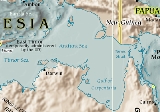
The Arafura Sea is bordered by Torres Straitand through that the Coral Sea
to the east, the Gulf of Carpentaria
to the south, the Timor Sea
to the west and the Banda
and Ceram
seas to the northwest. It is 1290 kilometres (801.6 mi) long and 560 kilometres (348 mi) wide. The depth of the sea is primarily 50–80 metres (165–265 feet) with the depth increasing to the west. As a shallow tropical sea, its waters are a breeding ground for tropical cyclones.
The sea lies over the Arafura Shelf, part of the Sahul Shelf
. When sea level
s were low during the last glacial maximum, the Arafura Shelf, the Gulf of Carpentaria and Torres Strait formed a large flat land bridge
connecting Australia and New Guinea and easing migration of humans from Asia
into Australia. The combined landmass formed the continent of Sahul.
Extent
The International Hydrographic Organization(IHO) defines the Arafura Sea as being one of the waters of the East Indian Archipelago
. The IHO defines its limits as follows:
On the North. The Southeastern limit of the Ceram SeaCeram SeaThe Ceram Sea or Seram Sea is one of several small seas between the scattered islands of Indonesia. It is a section of the Pacific Ocean with an area of approximately 12,000 square kilometers located between Buru and Seram, which are two of the islands once called the South Moluccas...
[A line from Karoefa, New Guinea, to the Southeastern extreme of Adi Island, thence to Tg. Borang, the Northern point of Noehoe Tjoet[ Kai BesarKai BesarKai Besar is one of the Kai Islands which are part of the Maluku Islands, Indonesia. Its area is 550 km². The other main island in the Kai Islands group is Kai Kecil . The northern tip is called Tanjung Borang, and southern tip called Tanjung Weduar....] (5°17′S 133°09′E)] and the Eastern limit of the Banda SeaBanda SeaThe Banda Sea is a sea in the Maluku Islands of Indonesia, technically part of the Pacific Ocean but separated from it by hundreds of islands, as well as the Halmahera and Ceram Seas...
[From Tg Borang, the Northern point of Noehoe Tjoet, through this island to its Southern point, thence a line to the Northeast point of Fordata, through this island and across to the Northeast point of Larat, Tanimbar IslandsTanimbar IslandsThe Tanimbar Islands, also called Timor Laut, are a group of about 65 islands in the Maluku province of Indonesia, including Fordata, Larat, Maru, Molu, Nuswotar, Selaru, Selu, Seira, Wotap, Wuliaru and Yamdena.-Geography:...
(7°06′S 131°55′E), down the East coast of Jamdena[ YamdenaYamdenaYamdena is the largest of the Tanimbar Islands in the Maluku Province of Indonesia. Saumlaki is the chief town, located on the south end of the island....] Island to its Southern point, thence through Anggarmasa to the North point of Selaroe and through this island to Tg Aro Oesoe its Southern point (8°21′S 130°45′E)].
On the East. The Southwest coast of New Guinea
New GuineaNew Guinea is the world's second largest island, after Greenland, covering a land area of 786,000 km2. Located in the southwest Pacific Ocean, it lies geographically to the east of the Malay Archipelago, with which it is sometimes included as part of a greater Indo-Australian Archipelago...
from Karoefa (133°27'E) to the entrance to the Bensbak River (141°01'E), and thence a line to the Northwest extreme of York PeninsulaCape York PeninsulaCape York Peninsula is a large remote peninsula located in Far North Queensland at the tip of the state of Queensland, Australia, the largest unspoilt wilderness in northern Australia and one of the last remaining wilderness areas on Earth...
, AustraliaAustraliaAustralia , officially the Commonwealth of Australia, is a country in the Southern Hemisphere comprising the mainland of the Australian continent, the island of Tasmania, and numerous smaller islands in the Indian and Pacific Oceans. It is the world's sixth-largest country by total area...
(11°05′S 142°03′E).
On the South. By the North coast of Australia from the Northwest extreme of York Peninsula to Cape Don (11°19′S 131°46′E).
On the West. A line from Cape Don to Tanjong Aro Oesoe, the Southern point of Selaroe (Tanimbar Islands
Tanimbar IslandsThe Tanimbar Islands, also called Timor Laut, are a group of about 65 islands in the Maluku province of Indonesia, including Fordata, Larat, Maru, Molu, Nuswotar, Selaru, Selu, Seira, Wotap, Wuliaru and Yamdena.-Geography:...
).
Name
The sea's name appeared in George Windsor Earl's 1837 "Sailing Directions for the Arafura" which he compiled from the narratives of Lieuts. Kolff and Modera of the Dutch Navy.
It has been suggested that the name Arafura is of Portuguese origin, being the corruption of the word "Alfours"meaning "free men", but recent research at the Dutch National Archives has revealed AJ van der Aa's 1939 Toponymic Dictionary records "the inhabitants of the Moluccas called themselves "haraforas",
Fisheries
The Arafura Sea is potentially a place for shrimp and demersal fishing. Shrimp available in this sea are penaeid sp in addition to basic fishes, nemipteridae sp, and other kind of fish.In a world where marine ecosystems and fish stocks are generally collapsing, the Arafura Sea stands out as among the richest marine fisheries in the world. However, the Arafura is coming under ever more intense pressure from illegal, unreported, and unregulated fishing activities. If this trend persists, the many local communities who surround the sea and who depend on fish protein will face a considerable challenge in sustaining their livelihoods.
Increasing economic growth and maintaining environment quality are two main challenges to achieve sustainable development in coastal areas of the sea. Utilization of marine and fisheries resources for economic development of particular area must be conducted in coordinative manner and through appropriate approaches, which take into consideration the sustainable aspects of the environment.
Established in 2002, the Arafura and Timor Seas Expert Forum (ATSEF) seeks to promote economically and environmentally sustainable management of the seas.
See also
- Asmat peopleAsmat peopleThe Asmat are an ethnic group of New Guinea, residing in the Papua province of Indonesia. Possessing one of the most well-known and vibrant woodcarving traditions in the Pacific, their art is sought by collectors worldwide...
- Makassan contact with Australia