
2000 Pacific typhoon season
Encyclopedia
The 2000 Pacific typhoon season has no official bounds; it ran year-round in 2000, but most tropical cyclones tend to form in the northwestern Pacific Ocean
between May and November. These dates conventionally delimit the period of each year when most tropical cyclones form in the northwestern Pacific Ocean
.
The scope of this article is limited to the Pacific Ocean, north of the equator and west of the international date line
. Storms that form east of the date line and north of the equator are called hurricanes; see 2000 Pacific hurricane season
. Tropical Storms formed in the entire west pacific basin are assigned a name by the Tokyo Typhoon Center. Tropical depressions in this basin have the "W" suffix added to their number. Tropical depressions that enter or form in the Philippine area of responsibility are assigned a name by the Philippine Atmospheric, Geophysical and Astronomical Services Administration
or PAGASA. This can often result in the same storm having two names.
(JTWC) to the JMA as the JTWC uses the United States
criteria of 1-minute mean to designate maximum sustained winds, while the JMA uses the 10-minute mean wind criteria to designate tropical cyclone maximum sustained winds. This difference generally results in JTWC maximum winds appearing higher than the maximum winds described by the JMA for the same typhoon.
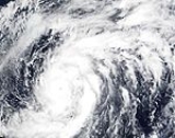
. This system gradually organized as it remained stationary, prompting the JTWC to issue a TCFA the following day. The JMA and JTWC began monitoring the disturbance as a tropical depression early on July 2, with the former classifying it as 05W. Several hours later, PAGASA also issued their first advisory on the depression, giving it the local name Ditang. Tracking northward, the system intensified into a tropical storm, at which time it received the name Kirogi, before undergoing rapid intensification late on July 3. Following this phase, the storm attained typhoon intensity and developed a well-defined 59 km (37 mi) wide symmetrical eye. Typhoon Kirogi attained its peak intensity early on July 4 with winds of 155 km/h (100 mph 10-minute sustained) and a barometric pressure of 940 mbar (hPa; 27.76 inHg).
In Japan, hundreds of residents were evacuated as Typhoon Kirogi approached the country. Since the storm weakened considerably from its peak intensity, damage was much less than initially anticipated. In all, damages from the storm amounted to 15 billion (2001 JPY
, $140 million USD
).
on the 9th. Kai-tak dissipated on the 11th over the Yellow Sea, after causing torrential flooding resulting in 188 fatalities. It was named after Hong Kong's old international airport, Kai Tak Airport
.
for "Urban". Despite a favourable environment, Upana never strengthened much, and it dissipated on July 23 for unexplained reasons. Upana's remnants continued moving to the west, and crossed the dateline
. Upana is the first storm in the Central Pacific Hurricane Center
's area of responsibility to be named in July.
The remnants of Upana encountered a favourable environment just west of the dateline, and they formed Tropical Depression 12W. The depression strengthened into Tropical Storm Chanchu. The name Chanchu, submitted by Macau
, is a Chinese word for pearl
. Chanchu moved north, and had dissipated by July 30.
Gary Padgett suggested that there was good evidence Chanchu was actually a regeneration of Upana. The official policy is that dateline crossers keep their name. However, there was supposedly some doubt at the time so Chanchu and Upana were officially treated as distinct tropical cyclones. Also, since Upana had dissipated several days earlier, and the Joint Typhoon Warning Center had already assigned a new number for the system, Gary Padgett deemed it likely that the Japan Meteorological Agency's decision to rename the cyclone was the best choice. http://australiasevereweather.com/cyclones/2001/summ0007.txt
on the 23rd. Significant rainfall fell across Taiwan, as up to 949 millimetres (37.4 in) was recorded across northeast sections of the mountainous island. Bilis was responsible for 17 deaths and $133.5 million in damage on Taiwan.
 On October 27, Typhoon Xangsane hit southern Luzon
of the Philippines. It turned to the north over the South China Sea, and after strengthening to a 100 mph typhoon it hit Taiwan. Xangsane dissipated on the 1st, after causing 181 casualties, 83 of which came from the Singapore Airlines Flight 006
airplane crash on October 31.
, due to the contraction of the wind field. Bebinca continued northwestward, eventually dissipating over the South China Sea on the 8th after killing 26 people.
near the center, and a pressure of 990 mbar. It dissipated on December 7.
.
developed into a midget tropical depression on June 18, 35 km south-southwest of Hong Kong. It moved northward and made landfall that day, with its very small circulation being well captured by the Observatory's network of automatic weather stations. The depression brought light rain to Hong Kong and moderate winds. Although this tropical depression was widely recognised by Asian agencies, there are still disputes on the nature of this system. It had an unusually small size and formed surprisingly close to land.
. It moved eastward along the west- east oriented surface pressure trough, and crossed the International Date Line
later on the 15th. Warmer than usual water temperatures allowed the system to intensify despite its unusually high latitude, and it became Tropical Storm Wene on the 16th. It quickly attained a peak intensity of 50 mph, but weakened due to cooler waters and wind shear. Wene continued to weaken, and dissipated when the storm merged with an extratropical cyclone.
As a depression, Wene was the first, and currently is the most recent Western Pacific tropical cyclone to cross the dateline since the 1996 season
. The name Wene is Hawaiian
for "Wayne".
. Previous typhoon season names were assigned by the Joint Typhoon Warning Center
. Names are now selected from the following lists, there is no annual list. Names were contributed by 13 members of the ESCAP/WMO Typhoon Committee, except for Singapore
. The 13 nations or territories, along with Micronesia
, each submitted 10 names, which are used in alphabetical order by the English name of the country. The first storm of 2000 was named Damrey and the final one was named Soulik.
Philippines
The Philippine Atmospheric, Geophysical and Astronomical Services Administration
(PAGASA) uses its own naming scheme for tropical cyclones within its area of responsibility. Lists are recycled every four years. This is the same list used for the 1996 season
.
Pacific Ocean
The Pacific Ocean is the largest of the Earth's oceanic divisions. It extends from the Arctic in the north to the Southern Ocean in the south, bounded by Asia and Australia in the west, and the Americas in the east.At 165.2 million square kilometres in area, this largest division of the World...
between May and November. These dates conventionally delimit the period of each year when most tropical cyclones form in the northwestern Pacific Ocean
Pacific Ocean
The Pacific Ocean is the largest of the Earth's oceanic divisions. It extends from the Arctic in the north to the Southern Ocean in the south, bounded by Asia and Australia in the west, and the Americas in the east.At 165.2 million square kilometres in area, this largest division of the World...
.
The scope of this article is limited to the Pacific Ocean, north of the equator and west of the international date line
International Date Line
The International Date Line is a generally north-south imaginary line on the surface of the Earth, passing through the middle of the Pacific Ocean, that designates the place where each calendar day begins...
. Storms that form east of the date line and north of the equator are called hurricanes; see 2000 Pacific hurricane season
2000 Pacific hurricane season
The 2000 Pacific hurricane season was an event in tropical cyclone meteorology. There were few notable storms this year. Tropical Storms Miriam, Norman, and Rosa all made landfall in Mexico with minimal impact. Hurricane Daniel briefly threatened the U.S. state of Hawaii while weakening...
. Tropical Storms formed in the entire west pacific basin are assigned a name by the Tokyo Typhoon Center. Tropical depressions in this basin have the "W" suffix added to their number. Tropical depressions that enter or form in the Philippine area of responsibility are assigned a name by the Philippine Atmospheric, Geophysical and Astronomical Services Administration
Philippine Atmospheric, Geophysical and Astronomical Services Administration
The Philippine Atmospheric, Geophysical and Astronomical Services Administration is a Philippine national institution dedicated to provide flood and typhoon warnings, public weather forecasts and advisories, meteorological, astronomical, climatological, and other specialized information and...
or PAGASA. This can often result in the same storm having two names.
Storms
In storm information below, wind-speed advisories differ from the Joint Typhoon Warning CenterJoint Typhoon Warning Center
The Joint Typhoon Warning Center is a joint United States Navy – United States Air Force task force located at the Naval Maritime Forecast Center in Pearl Harbor, Hawaii...
(JTWC) to the JMA as the JTWC uses the United States
United States
The United States of America is a federal constitutional republic comprising fifty states and a federal district...
criteria of 1-minute mean to designate maximum sustained winds, while the JMA uses the 10-minute mean wind criteria to designate tropical cyclone maximum sustained winds. This difference generally results in JTWC maximum winds appearing higher than the maximum winds described by the JMA for the same typhoon.
Typhoon Damrey (Asiang)
Typhoon Damrey, which formed on May 3, rapidly intensified on the 8th and 9th to a typhoon with 1-minute sustained winds of 285 km/h (180 mph) with a minimum central pressure of 930 hPa (mbar). It continued to the northeast, and vertical shear caused it to dissipate on the 12th. Damrey was the strongest May typhoon since Typhoon Phyllis in 1958 but Phyllis just had higher winds at 295 km/h (185 mph). Damrey had no significant effects on land in its life.Typhoon Kirogi (Ditang)
On June 30, an area of disturbed weather was identified roughly 650 km (405 mi) east of the Philippine island of MindanaoMindanao
Mindanao is the second largest and easternmost island in the Philippines. It is also the name of one of the three island groups in the country, which consists of the island of Mindanao and smaller surrounding islands. The other two are Luzon and the Visayas. The island of Mindanao is called The...
. This system gradually organized as it remained stationary, prompting the JTWC to issue a TCFA the following day. The JMA and JTWC began monitoring the disturbance as a tropical depression early on July 2, with the former classifying it as 05W. Several hours later, PAGASA also issued their first advisory on the depression, giving it the local name Ditang. Tracking northward, the system intensified into a tropical storm, at which time it received the name Kirogi, before undergoing rapid intensification late on July 3. Following this phase, the storm attained typhoon intensity and developed a well-defined 59 km (37 mi) wide symmetrical eye. Typhoon Kirogi attained its peak intensity early on July 4 with winds of 155 km/h (100 mph 10-minute sustained) and a barometric pressure of 940 mbar (hPa; 27.76 inHg).
In Japan, hundreds of residents were evacuated as Typhoon Kirogi approached the country. Since the storm weakened considerably from its peak intensity, damage was much less than initially anticipated. In all, damages from the storm amounted to 15 billion (2001 JPY
Japanese yen
The is the official currency of Japan. It is the third most traded currency in the foreign exchange market after the United States dollar and the euro. It is also widely used as a reserve currency after the U.S. dollar, the euro and the pound sterling...
, $140 million USD
United States dollar
The United States dollar , also referred to as the American dollar, is the official currency of the United States of America. It is divided into 100 smaller units called cents or pennies....
).
Typhoon Kai-tak (Edeng)
A tropical depression that developed on July 3 in the South China Sea drifted northward, becoming a storm on the 5th and a typhoon on the 6th. Kai-tak continued northward, hitting TaiwanTaiwan
Taiwan , also known, especially in the past, as Formosa , is the largest island of the same-named island group of East Asia in the western Pacific Ocean and located off the southeastern coast of mainland China. The island forms over 99% of the current territory of the Republic of China following...
on the 9th. Kai-tak dissipated on the 11th over the Yellow Sea, after causing torrential flooding resulting in 188 fatalities. It was named after Hong Kong's old international airport, Kai Tak Airport
Kai Tak Airport
Kai Tak Airport was the international airport of Hong Kong from 1925 until 1998. It was officially known as the Hong Kong International Airport from 1954 to 6 July 1998, when it was closed and replaced by the new Hong Kong International Airport at Chek Lap Kok, 30 km to the west...
.
Tropical Storm Chanchu
A tropical wave organized into Tropical Depression One-C on July 20. It strengthened slowly and moved nearly due west. After reaching storm strength on July 21, it was named Upana, which is HawaiianHawaiian language
The Hawaiian language is a Polynesian language that takes its name from Hawaii, the largest island in the tropical North Pacific archipelago where it developed. Hawaiian, along with English, is an official language of the state of Hawaii...
for "Urban". Despite a favourable environment, Upana never strengthened much, and it dissipated on July 23 for unexplained reasons. Upana's remnants continued moving to the west, and crossed the dateline
Dateline
A dateline is a brief piece of text included in news articles that describes where and when the story occurred, or was written or filed, though the date is often omitted. In the case of articles reprinted from wire services, the distributing organization is also included...
. Upana is the first storm in the Central Pacific Hurricane Center
Central Pacific Hurricane Center
The Central Pacific Hurricane Center of the United States National Weather Service is the official body responsible for tracking and issuing tropical cyclone warnings, watches, advisories, discussions, and statements for the Central North Pacific Basin...
's area of responsibility to be named in July.
The remnants of Upana encountered a favourable environment just west of the dateline, and they formed Tropical Depression 12W. The depression strengthened into Tropical Storm Chanchu. The name Chanchu, submitted by Macau
Macau
Macau , also spelled Macao , is, along with Hong Kong, one of the two special administrative regions of the People's Republic of China...
, is a Chinese word for pearl
Pearl
A pearl is a hard object produced within the soft tissue of a living shelled mollusk. Just like the shell of a mollusk, a pearl is made up of calcium carbonate in minute crystalline form, which has been deposited in concentric layers. The ideal pearl is perfectly round and smooth, but many other...
. Chanchu moved north, and had dissipated by July 30.
Gary Padgett suggested that there was good evidence Chanchu was actually a regeneration of Upana. The official policy is that dateline crossers keep their name. However, there was supposedly some doubt at the time so Chanchu and Upana were officially treated as distinct tropical cyclones. Also, since Upana had dissipated several days earlier, and the Joint Typhoon Warning Center had already assigned a new number for the system, Gary Padgett deemed it likely that the Japan Meteorological Agency's decision to rename the cyclone was the best choice. http://australiasevereweather.com/cyclones/2001/summ0007.txt
Typhoon Bilis (Isang)
On August 17, a tropical depression began its life in the Philippine Sea. It tracked northwestward, becoming a tropical storm on the 18th and a typhoon on the 19th. Bilis continued to intensify to a super typhoon on the 21st, and it struck the southeastern coast of Taiwan on the 22nd. It weakened slightly to a 140 miles per hour (225.3 km/h) typhoon while crossing the country, and hit ChinaPeople's Republic of China
China , officially the People's Republic of China , is the most populous country in the world, with over 1.3 billion citizens. Located in East Asia, the country covers approximately 9.6 million square kilometres...
on the 23rd. Significant rainfall fell across Taiwan, as up to 949 millimetres (37.4 in) was recorded across northeast sections of the mountainous island. Bilis was responsible for 17 deaths and $133.5 million in damage on Taiwan.
Tropical Storm Kaemi
It was reported that tropical storm Kaemi killed 14 persons in Vietnam.Typhoon Prapiroon (Lusing)
Prapiroon killed 46 people and caused $6 billion in damages in Korea.Typhoon Xangsane (Reming)
Luzon
Luzon is the largest island in the Philippines. It is located in the northernmost region of the archipelago, and is also the name for one of the three primary island groups in the country centered on the Island of Luzon...
of the Philippines. It turned to the north over the South China Sea, and after strengthening to a 100 mph typhoon it hit Taiwan. Xangsane dissipated on the 1st, after causing 181 casualties, 83 of which came from the Singapore Airlines Flight 006
Singapore Airlines Flight 006
Singapore Airlines Flight 006 was a scheduled passenger flight from Singapore Changi Airport to Los Angeles International Airport via Chiang Kai-shek Airport in Taiwan...
airplane crash on October 31.
Severe Tropical Storm Bebinca (Seniang)
On November 2, Tropical Storm Bebinca hit the central Philippines. It strengthened to a severe tropical storm and reached a peak of 60 knot winds while crossing the archipelagoArchipelago
An archipelago , sometimes called an island group, is a chain or cluster of islands. The word archipelago is derived from the Greek ἄρχι- – arkhi- and πέλαγος – pélagos through the Italian arcipelago...
, due to the contraction of the wind field. Bebinca continued northwestward, eventually dissipating over the South China Sea on the 8th after killing 26 people.
Severe Tropical Storm Rumbia (Toyang)
On November 28, 2000 a low pressure area together with inter-tropical covergence zone developed into a tropical depression. Later that day, JTWC announced that it became a tropical storm. It had maximum of winds of 75 mphMPH
MPH is a three-letter acronym that refers to miles per hour, a measurement of speedMPH may also refer to:* Make Poverty History, a campaign supported by Bob Geldof to end poverty in Africa...
near the center, and a pressure of 990 mbar. It dissipated on December 7.
Typhoon Soulik (Welpring)
Typhoon Soulik formed on December 30, 2000. It strengthened into a strong typhoon and had a central pressure of 955 mbar. It finally dissipated on January 4, 2001.Tropical Depression 04W
On May 30 The Joint Typhoon Warning Center (JTWC) issued a TCFA on a tropical disturbance located in the South China Sea. Later that day the JTWC upgraded it to a tropical depression designating it as TD 04W. The next day it reached its peak wind speed of 30 knots. on the 1st of June the JTWC issued its final Advisory on the 1st of June as it approached the coast of VietnamVietnam
Vietnam – sometimes spelled Viet Nam , officially the Socialist Republic of Vietnam – is the easternmost country on the Indochina Peninsula in Southeast Asia. It is bordered by China to the north, Laos to the northwest, Cambodia to the southwest, and the South China Sea –...
.
Tropical Depression
A vortex in an active trough over the South China SeaSouth China Sea
The South China Sea is a marginal sea that is part of the Pacific Ocean, encompassing an area from the Singapore and Malacca Straits to the Strait of Taiwan of around...
developed into a midget tropical depression on June 18, 35 km south-southwest of Hong Kong. It moved northward and made landfall that day, with its very small circulation being well captured by the Observatory's network of automatic weather stations. The depression brought light rain to Hong Kong and moderate winds. Although this tropical depression was widely recognised by Asian agencies, there are still disputes on the nature of this system. It had an unusually small size and formed surprisingly close to land.
- A technical report prepared by Hong Kong Observatory
Tropical Depression 07W (Gloring)
Cloudiness of TD Gloring (07W) was affected Northern Luzon , Central Luzon, Southern Luzon, Bicol Region, and Parts of Visayas. No damage and no casualties were affected.Tropical Depression 10W
JTWC treated 10W and 11W as separate depressions, although PAGASA and JMA both considered them the same system.Tropical Depression 16W (Wene)
A tropical disturbance developed in the Western Pacific Ocean along the eastern periphery of the monsoon trough in mid-August. Located at 33º north, it steadily organized, and became Tropical Depression Sixteen-W on August 15 while located 1700 miles to the northwest of Honolulu, HawaiiHonolulu, Hawaii
Honolulu is the capital and the most populous city of the U.S. state of Hawaii. Honolulu is the southernmost major U.S. city. Although the name "Honolulu" refers to the urban area on the southeastern shore of the island of Oahu, the city and county government are consolidated as the City and...
. It moved eastward along the west- east oriented surface pressure trough, and crossed the International Date Line
International Date Line
The International Date Line is a generally north-south imaginary line on the surface of the Earth, passing through the middle of the Pacific Ocean, that designates the place where each calendar day begins...
later on the 15th. Warmer than usual water temperatures allowed the system to intensify despite its unusually high latitude, and it became Tropical Storm Wene on the 16th. It quickly attained a peak intensity of 50 mph, but weakened due to cooler waters and wind shear. Wene continued to weaken, and dissipated when the storm merged with an extratropical cyclone.
As a depression, Wene was the first, and currently is the most recent Western Pacific tropical cyclone to cross the dateline since the 1996 season
1996 Pacific hurricane season
The 1996 Pacific hurricane season was an event in tropical cyclone formation and the third least active Pacific hurricane season in recorded history, behind 1977 and 2010. It officially began May 15, 1996 in the eastern north Pacific and on June 1, 1996 in the central north Pacific. It ended on...
. The name Wene is Hawaiian
Hawaiian language
The Hawaiian language is a Polynesian language that takes its name from Hawaii, the largest island in the tropical North Pacific archipelago where it developed. Hawaiian, along with English, is an official language of the state of Hawaii...
for "Wayne".
- CPHC archive for Wene.
- Monthly global tropical cyclone tracks for August found at Typhoon2000 http://www.typhoon2000.ph/garyp_mgtcs/aug00tks.txt
Tropical Depression Ulpiang
TD Ulpiang flooded and had landslides in Central Philippines and 3 casualties in landslides.Storm names
Western North Pacific tropical cyclones were now named by the RSMC Tokyo-Typhoon Center of the Japan Meteorological AgencyJapan Meteorological Agency
The or JMA, is the Japanese government's weather service. Charged with gathering and reporting weather data and forecasts in Japan, it is a semi-autonomous part of the Ministry of Land, Infrastructure and Transport...
. Previous typhoon season names were assigned by the Joint Typhoon Warning Center
Joint Typhoon Warning Center
The Joint Typhoon Warning Center is a joint United States Navy – United States Air Force task force located at the Naval Maritime Forecast Center in Pearl Harbor, Hawaii...
. Names are now selected from the following lists, there is no annual list. Names were contributed by 13 members of the ESCAP/WMO Typhoon Committee, except for Singapore
Singapore
Singapore , officially the Republic of Singapore, is a Southeast Asian city-state off the southern tip of the Malay Peninsula, north of the equator. An island country made up of 63 islands, it is separated from Malaysia by the Straits of Johor to its north and from Indonesia's Riau Islands by the...
. The 13 nations or territories, along with Micronesia
Micronesia
Micronesia is a subregion of Oceania, comprising thousands of small islands in the western Pacific Ocean. It is distinct from Melanesia to the south, and Polynesia to the east. The Philippines lie to the west, and Indonesia to the southwest....
, each submitted 10 names, which are used in alphabetical order by the English name of the country. The first storm of 2000 was named Damrey and the final one was named Soulik.
| Contributing Nation | Names | ||||
|---|---|---|---|---|---|
| Cambodia Cambodia Cambodia , officially known as the Kingdom of Cambodia, is a country located in the southern portion of the Indochina Peninsula in Southeast Asia... |
Damrey 01W | ||||
| China People's Republic of China China , officially the People's Republic of China , is the most populous country in the world, with over 1.3 billion citizens. Located in East Asia, the country covers approximately 9.6 million square kilometres... |
Longwang 02W | ||||
| DPR Korea North Korea The Democratic People’s Republic of Korea , , is a country in East Asia, occupying the northern half of the Korean Peninsula. Its capital and largest city is Pyongyang. The Korean Demilitarized Zone serves as the buffer zone between North Korea and South Korea... |
Kirogi 05W | ||||
| Hong Kong Hong Kong Hong Kong is one of two Special Administrative Regions of the People's Republic of China , the other being Macau. A city-state situated on China's south coast and enclosed by the Pearl River Delta and South China Sea, it is renowned for its expansive skyline and deep natural harbour... |
Kai-tak 06W | ||||
| Japan Japan Japan is an island nation in East Asia. Located in the Pacific Ocean, it lies to the east of the Sea of Japan, China, North Korea, South Korea and Russia, stretching from the Sea of Okhotsk in the north to the East China Sea and Taiwan in the south... |
Tembin 09W | ||||
| Laos Laos Laos Lao: ສາທາລະນະລັດ ປະຊາທິປະໄຕ ປະຊາຊົນລາວ Sathalanalat Paxathipatai Paxaxon Lao, officially the Lao People's Democratic Republic, is a landlocked country in Southeast Asia, bordered by Burma and China to the northwest, Vietnam to the east, Cambodia to the south and Thailand to the west... |
Bolaven 11W | ||||
| Macau Macau Macau , also spelled Macao , is, along with Hong Kong, one of the two special administrative regions of the People's Republic of China... |
Chanchu 12W | ||||
| Malaysia | Jelawat 13W | ||||
| Micronesia Micronesia Micronesia is a subregion of Oceania, comprising thousands of small islands in the western Pacific Ocean. It is distinct from Melanesia to the south, and Polynesia to the east. The Philippines lie to the west, and Indonesia to the southwest.... |
Ewiniar 15W | ||||
| Philippines Philippines The Philippines , officially known as the Republic of the Philippines , is a country in Southeast Asia in the western Pacific Ocean. To its north across the Luzon Strait lies Taiwan. West across the South China Sea sits Vietnam... |
Bilis 18W | ||||
| RO Korea South Korea The Republic of Korea , , is a sovereign state in East Asia, located on the southern portion of the Korean Peninsula. It is neighbored by the People's Republic of China to the west, Japan to the east, North Korea to the north, and the East China Sea and Republic of China to the south... |
Kaemi 19W | ||||
| Thailand Thailand Thailand , officially the Kingdom of Thailand , formerly known as Siam , is a country located at the centre of the Indochina peninsula and Southeast Asia. It is bordered to the north by Burma and Laos, to the east by Laos and Cambodia, to the south by the Gulf of Thailand and Malaysia, and to the... |
Prapiroon 20W | ||||
| U.S.A. United States The United States of America is a federal constitutional republic comprising fifty states and a federal district... |
Maria 21W | ||||
| Vietnam Vietnam Vietnam – sometimes spelled Viet Nam , officially the Socialist Republic of Vietnam – is the easternmost country on the Indochina Peninsula in Southeast Asia. It is bordered by China to the north, Laos to the northwest, Cambodia to the southwest, and the South China Sea –... |
Saomai 22W | ||||
| Cambodia Cambodia Cambodia , officially known as the Kingdom of Cambodia, is a country located in the southern portion of the Indochina Peninsula in Southeast Asia... |
Bopha 24W | ||||
| China People's Republic of China China , officially the People's Republic of China , is the most populous country in the world, with over 1.3 billion citizens. Located in East Asia, the country covers approximately 9.6 million square kilometres... |
Wukong 23W | ||||
| DPR Korea North Korea The Democratic People’s Republic of Korea , , is a country in East Asia, occupying the northern half of the Korean Peninsula. Its capital and largest city is Pyongyang. The Korean Demilitarized Zone serves as the buffer zone between North Korea and South Korea... |
Sonamu 25W | ||||
| Hong Kong Hong Kong Hong Kong is one of two Special Administrative Regions of the People's Republic of China , the other being Macau. A city-state situated on China's south coast and enclosed by the Pearl River Delta and South China Sea, it is renowned for its expansive skyline and deep natural harbour... |
Shanshan 26W | ||||
| Japan Japan Japan is an island nation in East Asia. Located in the Pacific Ocean, it lies to the east of the Sea of Japan, China, North Korea, South Korea and Russia, stretching from the Sea of Okhotsk in the north to the East China Sea and Taiwan in the south... |
Yagi 29W | ||||
| Laos Laos Laos Lao: ສາທາລະນະລັດ ປະຊາທິປະໄຕ ປະຊາຊົນລາວ Sathalanalat Paxathipatai Paxaxon Lao, officially the Lao People's Democratic Republic, is a landlocked country in Southeast Asia, bordered by Burma and China to the northwest, Vietnam to the east, Cambodia to the south and Thailand to the west... |
Xangsane 30W | ||||
| Macau Macau Macau , also spelled Macao , is, along with Hong Kong, one of the two special administrative regions of the People's Republic of China... |
Bebinca 31W | ||||
| Malaysia | Rumbia 33W | ||||
| Micronesia Micronesia Micronesia is a subregion of Oceania, comprising thousands of small islands in the western Pacific Ocean. It is distinct from Melanesia to the south, and Polynesia to the east. The Philippines lie to the west, and Indonesia to the southwest.... |
Soulik 34W | ||||
| Philippines Philippines The Philippines , officially known as the Republic of the Philippines , is a country in Southeast Asia in the western Pacific Ocean. To its north across the Luzon Strait lies Taiwan. West across the South China Sea sits Vietnam... |
|||||
| RO Korea South Korea The Republic of Korea , , is a sovereign state in East Asia, located on the southern portion of the Korean Peninsula. It is neighbored by the People's Republic of China to the west, Japan to the east, North Korea to the north, and the East China Sea and Republic of China to the south... |
|||||
| Thailand Thailand Thailand , officially the Kingdom of Thailand , formerly known as Siam , is a country located at the centre of the Indochina peninsula and Southeast Asia. It is bordered to the north by Burma and Laos, to the east by Laos and Cambodia, to the south by the Gulf of Thailand and Malaysia, and to the... |
|||||
| U.S.A. | |||||
| Vietnam Vietnam Vietnam – sometimes spelled Viet Nam , officially the Socialist Republic of Vietnam – is the easternmost country on the Indochina Peninsula in Southeast Asia. It is bordered by China to the north, Laos to the northwest, Cambodia to the southwest, and the South China Sea –... |
PhilippinesPhilippinesThe Philippines , officially known as the Republic of the Philippines , is a country in Southeast Asia in the western Pacific Ocean. To its north across the Luzon Strait lies Taiwan. West across the South China Sea sits Vietnam...
The Philippine Atmospheric, Geophysical and Astronomical Services AdministrationPhilippine Atmospheric, Geophysical and Astronomical Services Administration
The Philippine Atmospheric, Geophysical and Astronomical Services Administration is a Philippine national institution dedicated to provide flood and typhoon warnings, public weather forecasts and advisories, meteorological, astronomical, climatological, and other specialized information and...
(PAGASA) uses its own naming scheme for tropical cyclones within its area of responsibility. Lists are recycled every four years. This is the same list used for the 1996 season
1996 Pacific typhoon season
The 1996 Pacific typhoon season has no official bounds; it ran year-round in 1996, but most tropical cyclones tend to form in the northwestern Pacific Ocean between May and November...
.
|
|
|
|
|
See also
- List of Pacific typhoon seasons
- 2000 Pacific hurricane season2000 Pacific hurricane seasonThe 2000 Pacific hurricane season was an event in tropical cyclone meteorology. There were few notable storms this year. Tropical Storms Miriam, Norman, and Rosa all made landfall in Mexico with minimal impact. Hurricane Daniel briefly threatened the U.S. state of Hawaii while weakening...
- 2000 Atlantic hurricane season2000 Atlantic hurricane seasonThe 2000 Atlantic hurricane season was the first season without a tropical cyclone in July since 1987. The season officially began on June 1, 2000, and lasted until November 30, 2000. The June through November dates conventionally delimit the period of each year when most tropical cyclones form in...
- 2000 North Indian Ocean cyclone season2000 North Indian Ocean cyclone seasonThe 2000 North Indian Ocean cyclone season had no bounds, but cyclones tend to form between April and December, with peaks in May and November. These dates conventionally delimit the period of each year when most tropical cyclones form in the northern Indian Ocean.-Season summary:Six tropical...
- South-West Indian Ocean cyclone seasons: 1999-001999-00 South-West Indian Ocean cyclone seasonThe 1999-00 South-West Indian Ocean tropical cyclone season was an event in the annual cycle of tropical cyclone formation and ran from November 1, 1999 to April 30, 2000 in the South-West Indian Ocean, with the exception of Mauritius and the Seychelles, for which it ran until May 15.Cyclone...
, 2000-012000-01 South-West Indian Ocean cyclone seasonThe 2000-01 South-West Indian Ocean cyclone season was an annual event of tropical cyclone formation. It started on November 15, 2000 and ended on April 30, 2001. For Mauritius and the Seychelles, the season continued until May 15. These dates conventionally delimit the period of each year when... - Australian region cyclone seasons: 1999-00, 2000-01
- South Pacific cyclone seasons: 1999-001999-00 South Pacific cyclone seasonThe 1999-00 South Pacific tropical cyclone season was an event in the annual cycle of tropical cyclone formation and ran from November 1, 1999 to April 30, 2000 in the South Pacific....
, 2000-012000-01 South Pacific cyclone seasonThe 2000–01 South Pacific cyclone season was an event in the annual cycle of tropical cyclone formation. It began on November 1, 2000 and ended on April 30, 2001. These dates conventionally delimit the period of each year when most tropical cyclones form in the southern Pacific Ocean east of 160°E...
External links
- Japan Meteorological Agency
- Satellite movie of 2000 Pacific typhoon season
- China Meteorological Agency
- National Weather Service Guam
- Hong Kong Observatory
- Macau Meteorological Geophysical Services
- Korea Meteorological Agency
- Philippine Atmospheric, Geophysical and Astronomical Services Administration
- Taiwan Central Weather Bureau
- Joint Typhoon Warning Center
- Digital Typhoon - Typhoon Images and Information
- Typhoon2000 Philippine typhoon website