
2000 Pacific hurricane season
Encyclopedia
The 2000 Pacific hurricane season was an event in tropical cyclone
meteorology
. There were few notable storms this year. Tropical Storms Miriam, Norman, and Rosa all made landfall in Mexico
with minimal impact. Hurricane Daniel briefly threatened the U.S. state
of Hawaii
while weakening. Hurricane Carlotta
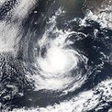
was the strongest storm of the year and the second strongest June hurricane in recorded history. It killed 18 people when it sank a freighter.
 The 2000 Pacific hurricane season officially started on May 15, 2000 in the eastern Pacific, and on June 1, 2000 in the central Pacific, and lasted until November 30, 2000. These dates conventionally delimit the period of each year when most tropical cyclones form in the northeastern Pacific Ocean
.
This season had an above average number of storms. However, it had a below average number of hurricanes and major hurricanes. There were also two tropical depressions that did not reach storm strength. In the central Pacific, two tropical storms formed. The first storm formed on May 22 and the last storm dissipated on November 8.
and entered the Gulf of Tehuantepec
on May 20. Deep convection
developed near a center, and the system became the first tropical depression of the season on May 22 while located south of Acapulco
, Mexico. A mid-level ridge
forced a west-northwest track away from the Mexican coast. It intensified into Tropical Storm Aletta early on May 23 while located 220 mi (350 km) south of Zihuatanejo
, Mexico, becoming the first May tropical storm in four years. As it turned westward, it continued a slow intensification trend, before strengthening more quickly due to decreased wind shear
. On May 24 Aletta attained hurricane status, and shortly thereafter reached peak winds of 105 mph (165 km/h); this made it a Category 2 on the Saffir-Simpson scale
.
After maintaining peak winds for about 18 hours, Aletta began a weakening trend due to increasing wind shear. At around the same time, a trough
eroded the ridge that was steering the movement of Aletta, causing the hurricane to remain almost stationary for the next two days. The lack of motion resulted in upwelling
which imparted additional weakening, and Aletta weakened to tropical storm status on May 27. It quickly deteriorated that day, and on May 28 the system dissipated well south of Cabo San Lucas
after it began a slow north drift. The remnants lingered in the same area for the next several days. Aletta caused no known damages or casualties. Hurricane Aletta was the second-strongest May hurricane by pressure, as well as the fourth strongest May hurricane by winds.
on May 22. It moved across the Atlantic Ocean
and Caribbean Sea
, then into the eastern Pacific Ocean
on June 6 with little development. The tropical wave remained disorganized until June 11 when a broad low pressure area
developed southwest of Acapulco, Mexico. The wave was only intensifying slowly, and on June 13, it became strong enough to be designated as a tropical depression. It quickly strengthened to tropical storm intensity six hours later, and moved to the northwest. It was forecast to strengthen to a strong tropical storm with winds reaching 70 mph (110 km/h), but the storm only reached a peak intensity of 50 mph (85 km/h) early on June 14. Bud turned to the north-northwest, and slowly weakened from June 15 onwards, due to increasing vertical wind shear and cooler ocean water temperatures. The storm's forward speed decreased and began to meander, as the ridge to the north of Bud weakens and a trough develops over the western United States
. It drifted erratically while located just north of Socorro Island
, and was downgraded to a tropical depression on June 16. By the next day, it dissipated into an area of low pressure, however, it continued to exist until June 19.
Bud passed near Socorro Island on June 15, with estimated one minute winds of 45 mph (75 km/h), and caused large waves along the western coast of Mexico. However, no reports of damage or casualties were received.
Though it never made landfall, Carlotta killed 18 people when it sank the Lithuanian freighter
M/V Linkuva. Carlotta is also the third most intense June tropical cyclone in the east Pacific; only Ava
of 1973 and Celia
of 2010 were stronger.
s were warm enough for intensification to occur. The depression lacked any deep convection, however, and it began weakening on the next day. It was dissipating late in the day as the storm moved into an area of stronger wind shear.
. It strengthened slowly and moved nearly due west, before reaching storm strength later on July 20. The storm was named Upana, which is Hawaiian
for "Urban". Despite a favorable environment, Upana strengthened little, reaching a peak intensity on July 21 with winds of 50 mph (85 km/h). The storm had no deep convection
in its circulation on July 22, and was downgraded to a tropical depression in the afternoon. Late on July 23, deep convection flared up, briefly strengthening the storm, but failed to become a tropical storm again, as it remained poorly organized. It dissipated on July 24, despite a low shear environment favorable for development.
Upana is the first storm in the Central Pacific Hurricane Center
's area of responsibility to be named in July, and the first tropical storm to develop in the region since Tropical Storm Paka in the 1997 season
. Upana's remnants continued moving to the west, and it crossed the International Date Line
on July 26. The remnants encountered a favorable environment just west of the dateline, and developed into Tropical Depression 12W. The depression strengthened into Tropical Storm Chanchu. The name Chanchu, submitted by Macau
, is a Chinese word for pearl
. Chanchu moved north, and had dissipated by July 30.
Gary Padgett suggested that there was good evidence Chanchu was actually a regeneration of Upana. The official policy is that dateline crossers keep their name. However, there was supposedly some doubt at the time so Chanchu and Upana were officially treated as distinct tropical cyclones. Also, since Upana had dissipated several days earlier, and the Joint Typhoon Warning Center
had already assigned a new number for the system, Gary Padgett deemed it likely that the Japan Meteorological Agency
's decision to rename the cyclone was the best choice.
as a tropical storm, but veered to the northwest as it approached the islands.
No casualties or damaged was reported in association with Hurricane Daniel, despite the system's passing close enough to Hawaii to require tropical storm warnings
. It still produced heavy surf conditions along the northern shores of the Hawaiian Islands
. Daniel was the first tropical cyclone to be a significant threat to Hawaii since 1994
.
one week later. It passed over Central America near Panama
on July 22 without any increase in organization. On July 25, the wave began to show curved banding, showing that it had become better organized. It intensified to a tropical depression on July 26 while located south southwest of Manzanillo, Mexico, designated as Tropical Depression Seven-E. The depression was upgraded to Tropical Storm Emilia later that day while moving northwest, steered by a mid-level ridge
to its north. During this time, Emilia was forecast to strengthen to a hurricane within two days, due to the system moving over warm waters. However, late on July 27, the storm began to accelerate, meaning that it will move into cooler waters sooner than firstly anticipated, therefore, only allowing the storm to intensify within a few hours before weakening. Emilia moved near Socorro Island and it's intensity peaked with wind speeds of 65 mph (100 km/h), with an eyewall
beginning to form. A few hours later, the storm moved into cooler waters and drier air, and Emilia's deep convection dissipated, weakening the storm. Late on July 28 deep convection redeveloped near the storm's center, but wind shear prevented Emilia from strengthening. It turned to the west and weakened below tropical storm intensity on July 29, as the deep convection in the storm diminished again. It shortly dissipated while located several hundred miles west south-west of Cabo San Lucas
, Mexico.
. It moved eastward along the west-east oriented surface pressure trough, and crossed the International Date Line
later on August 15. Abnormally warm sea surface temperatures allowed the system to intensify despite its unusually high latitude, and it became Tropical Storm Wene on August 16. It quickly attained a peak intensity of 50 mph (85 km/h), but weakened due to colder sea surface temperatures and wind shear. Wene continued to weaken, and dissipated when the storm merged with an extratropical cyclone.
As a depression, Wene was the first, and currently is the most recent Western Pacific tropical cyclone to cross the dateline since the 1996 season
. The name Wene is Hawaiian
for "Wayne".
(ITCZ) near just outside the Central Pacific basin. Developing near the Central Pacific basin, John eventually entered early on August 30 and was then also monitored by the Central Pacific Hurricane Center
. that was a tropical storm for several days and moved from the eastern to the central Pacific basin. Thereafter entering the central Pacific region, Tropical Storm John approached hurricane status while meandering erratically east-southeast of Hawaii. John eventually encountered strong wind shear, and dissipated on September 1. Tropical Storm John did not cause any damage or fatalities, as there were no reports of any land being affect.
uneventfully crossed the rest of the Atlantic and passed far out to sea into the Pacific before it organized into Tropical Depression Fourteen-E on August 31. Despite significant shear, the depression strengthened into Tropical Storm Kristy as it meandered far from land over the open ocean. The shear then destroyed the system on September 3 where it was at a place just 210 kilometers from where it first organized. There were no effects anywhere.
. By September 11, Lane encountered cooler waters which weakened the hurricane back to tropical storm strength. Lane then encountered a trough
that had formed off the western United States
coastline. The interaction with the system caused Lane to curve northeast towards the West Coast of the United States
. On September 13, Lane passed over cooler waters, causing it to weaken to a tropical depression. Lane then dissipated on the next day.
On September 9, forecasters predicted that the storm would remain offshore and its rainbands would bring heavy rains and gusty winds across the Baja California
. However, because forecasters predicted that the storm would stay offshore, and so no warnings or watches were issued. Lane passed directly over Socorro Island
where a weather station recorded a pressure of 973 mb. Although the center of Lane was well offshore, it still brought heavy surf that closed several ports in Mexico. In an Jose del Cabo, Mexico, a weather station reported winds of 32 mph (52 km/h). Lane remnants then affected the Western United States
. The moisture from Lane produced thunderstorms in northern California
. At all locations, effects were minimal, with no reports of damage or casualties.
, Baja California Sur
. Banding features became more pronounced, though convection remained intermittent. On September 16, the depression briefly became Tropical Storm Miriam, though quickly weakened back to a tropical depression as it continued north-northwestward. Miriam dissipated on September 17 while 70 miles (112.6 km) northeast of Cabo San Lucas. Tropical storm force winds were never reported, and it is possible Miriam never attained tropical storm status.
Miriam dropped lighter than average rainfall upon Mexico, peaking at 7.68 in (195.1 mm) at La Cruz/Elota. Total damages from the storm amounted to $7.2 million (MXN
; $558,000 2000 USD, $ USD). By October 24, a national disaster declaration was signed for areas affected by Tropical Storm Miriam in Baja California Sur.
organized into an area of low pressure in the Eastern Pacific Ocean on September 18. Its convection slowly organized while south of Mexico, and a tropical depression formed on September 20 while 205 miles (330 km) south-southeast of Manzanillo, Colima. Weak steering currents forced the depression to drift slowly northward, and later on September 20 it strengthened into Tropical Storm Norman. Norman quickly reached peak winds of 50 mph (85 km/h) before making landfall in western Mexico. The storm rapidly weakened to a tropical depression over land, but Norman maintained its circulation and some deep convection as it turned to the northwest. It emerged over water on September 22, but turned to the northeast, made landfall again in Mexico, and dissipated later that day.
Norman produced heavy rainfall across western Mexico, peaking at nearly 16 in (406.4 mm) in the state of Colima. In all, Norman caused $13.3 million (2000 USD; $ USD) in damage.
(ITCZ) on October 22. Located several hundred miles south-southeast of the Gulf of Tehuantepec
, convection gradually organized and increased, and by October 25 satellite images indicated the development of the eighteenth tropical depression of the season. Operationally it was not classified until 15 hours later. The depression moved westward throughout its duration, and based on Dvorak estimates, intensified into Tropical Storm Paul on October 26. Despite increasing wind shear ahead of the storm, the National Hurricane Center predicted steady intensification to near hurricane status, although Paul only attained peak winds of 45 mph (75 km/h).
As the wind shear increased and its convection became disorganized, Paul weakened. It briefly turned to the northwest due to a trough
, before resuming its westward motion. Although the convection was becoming displaced from the low-level circulation, the National Hurricane Center continued to predict strengthening. However, the thunderstorms became minimal, and Paul weakened to tropical depression status early on October 28. The circulation center deteriorated, and although there were occasional brief increases in convection, Paul dissipated early on October 29, as it was becoming indistinguishable in the ITCZ. The remnants continued westward, and interacted with an upper-level low, affecting Hawaii with heavy rainfall in early November 2000. The flooding caused $70 million (2000 USD; $ USD) in damage, and the highest rainfall total was 38.76 in (984.5 mm) at Kapapala Ranch. That rainfall total makes Paul Hawaii's second rainiest tropical cyclone, behind only Hurricane Hiki
of 1950.
– Guatemala
border. A ridge of high pressure to its north forced the depression westward, where it slowly organized into a tropical storm on November 5. A mid-level trough eroded the high pressure system, allowing Rosa to turn more to the north. On November 6, the storm reached a peak of 65 mph (100 km/h), though Rosa slowly weakened as it accelerated to the northeast. On November 8, the storm made landfall on the southern coast of Mexico with winds of 40 mph (65 km/h), and quickly dissipated.
Rosa dropped moderate rainfall across Mexico, peaking at 15.32 in (389 mm) near the Mexico/Guatemala border. Damage was minimal, totaling to only $15,000 (2000 USD; $ USD). Rosa was the first November storm since Hurricane Rick
in the 1997 season
.
. This is the same list used for the 1994 season
.
Two names were used from the Central Pacific list — Upana and Wene.
Tropical cyclone
A tropical cyclone is a storm system characterized by a large low-pressure center and numerous thunderstorms that produce strong winds and heavy rain. Tropical cyclones strengthen when water evaporated from the ocean is released as the saturated air rises, resulting in condensation of water vapor...
meteorology
Meteorology
Meteorology is the interdisciplinary scientific study of the atmosphere. Studies in the field stretch back millennia, though significant progress in meteorology did not occur until the 18th century. The 19th century saw breakthroughs occur after observing networks developed across several countries...
. There were few notable storms this year. Tropical Storms Miriam, Norman, and Rosa all made landfall in Mexico
Mexico
The United Mexican States , commonly known as Mexico , is a federal constitutional republic in North America. It is bordered on the north by the United States; on the south and west by the Pacific Ocean; on the southeast by Guatemala, Belize, and the Caribbean Sea; and on the east by the Gulf of...
with minimal impact. Hurricane Daniel briefly threatened the U.S. state
U.S. state
A U.S. state is any one of the 50 federated states of the United States of America that share sovereignty with the federal government. Because of this shared sovereignty, an American is a citizen both of the federal entity and of his or her state of domicile. Four states use the official title of...
of Hawaii
Hawaii
Hawaii is the newest of the 50 U.S. states , and is the only U.S. state made up entirely of islands. It is the northernmost island group in Polynesia, occupying most of an archipelago in the central Pacific Ocean, southwest of the continental United States, southeast of Japan, and northeast of...
while weakening. Hurricane Carlotta
Hurricane Carlotta (2000)
Hurricane Carlotta was the most powerful hurricane of the 2000 Pacific hurricane season. The third tropical cyclone of the season, Carlotta developed from a tropical wave on June 18 about 270 miles southeast off the coast of Mexico...
was the strongest storm of the year and the second strongest June hurricane in recorded history. It killed 18 people when it sank a freighter.
Season summary
Pacific Ocean
The Pacific Ocean is the largest of the Earth's oceanic divisions. It extends from the Arctic in the north to the Southern Ocean in the south, bounded by Asia and Australia in the west, and the Americas in the east.At 165.2 million square kilometres in area, this largest division of the World...
.
This season had an above average number of storms. However, it had a below average number of hurricanes and major hurricanes. There were also two tropical depressions that did not reach storm strength. In the central Pacific, two tropical storms formed. The first storm formed on May 22 and the last storm dissipated on November 8.
Hurricane Aletta
A tropical wave crossed Central AmericaCentral America
Central America is the central geographic region of the Americas. It is the southernmost, isthmian portion of the North American continent, which connects with South America on the southeast. When considered part of the unified continental model, it is considered a subcontinent...
and entered the Gulf of Tehuantepec
Gulf of Tehuantepec
Gulf of Tehuantepec is a large body of water on the Pacific coast of the Isthmus of Tehuantepec, southeastern Mexico, at . Most of the hurricanes that form in the Eastern Pacific organize in or near this body of water...
on May 20. Deep convection
Convection
Convection is the movement of molecules within fluids and rheids. It cannot take place in solids, since neither bulk current flows nor significant diffusion can take place in solids....
developed near a center, and the system became the first tropical depression of the season on May 22 while located south of Acapulco
Acapulco
Acapulco is a city, municipality and major sea port in the state of Guerrero on the Pacific coast of Mexico, southwest from Mexico City. Acapulco is located on a deep, semi-circular bay and has been a port since the early colonial period of Mexico’s history...
, Mexico. A mid-level ridge
Ridge (meteorology)
A ridge is an elongated region of relatively high atmospheric pressure, the opposite of a trough....
forced a west-northwest track away from the Mexican coast. It intensified into Tropical Storm Aletta early on May 23 while located 220 mi (350 km) south of Zihuatanejo
Zihuatanejo
Zihuatanejo or Ixtapa-Zihuatanejo, is the fourth-largest city in the Mexican state of Guerrero. Politically the city belongs to the municipality of Zihuatanejo de Azueta in the western part of Guerrero, but both are commonly referred to as Zihuatanejo...
, Mexico, becoming the first May tropical storm in four years. As it turned westward, it continued a slow intensification trend, before strengthening more quickly due to decreased wind shear
Wind shear
Wind shear, sometimes referred to as windshear or wind gradient, is a difference in wind speed and direction over a relatively short distance in the atmosphere...
. On May 24 Aletta attained hurricane status, and shortly thereafter reached peak winds of 105 mph (165 km/h); this made it a Category 2 on the Saffir-Simpson scale
Saffir-Simpson Hurricane Scale
The Saffir–Simpson Hurricane Scale , or the Saffir–Simpson Hurricane Wind Scale , classifies hurricanes — Western Hemisphere tropical cyclones that exceed the intensities of tropical depressions and tropical storms — into five categories distinguished by the intensities of their sustained winds...
.
After maintaining peak winds for about 18 hours, Aletta began a weakening trend due to increasing wind shear. At around the same time, a trough
Trough (meteorology)
A trough is an elongated region of relatively low atmospheric pressure, often associated with fronts.Unlike fronts, there is not a universal symbol for a trough on a weather chart. The weather charts in some countries or regions mark troughs by a line. In the United States, a trough may be marked...
eroded the ridge that was steering the movement of Aletta, causing the hurricane to remain almost stationary for the next two days. The lack of motion resulted in upwelling
Upwelling
Upwelling is an oceanographic phenomenon that involves wind-driven motion of dense, cooler, and usually nutrient-rich water towards the ocean surface, replacing the warmer, usually nutrient-depleted surface water. The increased availability in upwelling regions results in high levels of primary...
which imparted additional weakening, and Aletta weakened to tropical storm status on May 27. It quickly deteriorated that day, and on May 28 the system dissipated well south of Cabo San Lucas
Cabo San Lucas
Cabo San Lucas , commonly called Cabo, is a city at the southern tip of the Baja California peninsula, in the municipality of Los Cabos in the Mexican state of Baja California Sur. As of the 2010 census, the population was 68,463 people...
after it began a slow north drift. The remnants lingered in the same area for the next several days. Aletta caused no known damages or casualties. Hurricane Aletta was the second-strongest May hurricane by pressure, as well as the fourth strongest May hurricane by winds.
Tropical Storm Bud
A tropical wave that will eventually become Tropical Storm Bud was first identified off the coast of AfricaAfrica
Africa is the world's second largest and second most populous continent, after Asia. At about 30.2 million km² including adjacent islands, it covers 6% of the Earth's total surface area and 20.4% of the total land area...
on May 22. It moved across the Atlantic Ocean
Atlantic Ocean
The Atlantic Ocean is the second-largest of the world's oceanic divisions. With a total area of about , it covers approximately 20% of the Earth's surface and about 26% of its water surface area...
and Caribbean Sea
Caribbean Sea
The Caribbean Sea is a sea of the Atlantic Ocean located in the tropics of the Western hemisphere. It is bounded by Mexico and Central America to the west and southwest, to the north by the Greater Antilles, and to the east by the Lesser Antilles....
, then into the eastern Pacific Ocean
Pacific Ocean
The Pacific Ocean is the largest of the Earth's oceanic divisions. It extends from the Arctic in the north to the Southern Ocean in the south, bounded by Asia and Australia in the west, and the Americas in the east.At 165.2 million square kilometres in area, this largest division of the World...
on June 6 with little development. The tropical wave remained disorganized until June 11 when a broad low pressure area
Low pressure area
A low-pressure area, or "low", is a region where the atmospheric pressure at sea level is below that of surrounding locations. Low-pressure systems form under areas of wind divergence which occur in upper levels of the troposphere. The formation process of a low-pressure area is known as...
developed southwest of Acapulco, Mexico. The wave was only intensifying slowly, and on June 13, it became strong enough to be designated as a tropical depression. It quickly strengthened to tropical storm intensity six hours later, and moved to the northwest. It was forecast to strengthen to a strong tropical storm with winds reaching 70 mph (110 km/h), but the storm only reached a peak intensity of 50 mph (85 km/h) early on June 14. Bud turned to the north-northwest, and slowly weakened from June 15 onwards, due to increasing vertical wind shear and cooler ocean water temperatures. The storm's forward speed decreased and began to meander, as the ridge to the north of Bud weakens and a trough develops over the western United States
United States
The United States of America is a federal constitutional republic comprising fifty states and a federal district...
. It drifted erratically while located just north of Socorro Island
Socorro Island
Socorro Island is a small volcanic island in the Revillagigedo Islands, a Mexican possession lying some 600 kilometers off the country's western coast at 18°48'N, 110°59'W. The size is 16.5 by 11.5 km, with an area of 132 km².- Geology :...
, and was downgraded to a tropical depression on June 16. By the next day, it dissipated into an area of low pressure, however, it continued to exist until June 19.
Bud passed near Socorro Island on June 15, with estimated one minute winds of 45 mph (75 km/h), and caused large waves along the western coast of Mexico. However, no reports of damage or casualties were received.
Hurricane Carlotta
A tropical wave that entered the Pacific Ocean acquired a closed circulation and became a depression on June 18. It strengthened into a storm June 19 and a hurricane the next day. Carlotta then began explosively deepening, and it strengthened into a Category 4 hurricane on June 21. It then began to reduce its forward speed and slowly weaken as its path paralleled the Pacific coast of Mexico. Carlotta weakened to a storm on June 24 and a depression June 25. The cyclone dissipated shortly thereafter.Though it never made landfall, Carlotta killed 18 people when it sank the Lithuanian freighter
Cargo ship
A cargo ship or freighter is any sort of ship or vessel that carries cargo, goods, and materials from one port to another. Thousands of cargo carriers ply the world's seas and oceans each year; they handle the bulk of international trade...
M/V Linkuva. Carlotta is also the third most intense June tropical cyclone in the east Pacific; only Ava
Hurricane Ava (1973)
Hurricane Ava was one of the strongest tropical cyclones ever recorded in the northeastern Pacific Ocean. It was the first named storm of the 1973 Pacific hurricane season. Forming in early June, Hurricane Ava eventually reached Category 5 intensity on the Saffir-Simpson Hurricane Scale, the...
of 1973 and Celia
Hurricane Celia (2010)
Hurricane Celia was a powerful, early-season Category 5 tropical cyclone that existed over the open waters of the eastern Pacific Ocean during late June 2010...
of 2010 were stronger.
Tropical Depression Four-E
Tropical Depression Four-E was a short-lived storm that formed from the same tropical wave that spawned Tropical Depression Two in the Atlantic Ocean. The tropical wave crossed Central America between June 30 and July 1, continuing to move westward into the Pacific Ocean. The wave became more organized on July 6 and the National Hurricane Center started issuing advisories on the newly developed tropical depression later that day. The hurricane center predicted that the depression will reach tropical storm intensity, as there was a lack of vertical wind shear around the system and sea surface temperatureSea surface temperature
Sea surface temperature is the water temperature close to the oceans surface. The exact meaning of surface varies according to the measurement method used, but it is between and below the sea surface. Air masses in the Earth's atmosphere are highly modified by sea surface temperatures within a...
s were warm enough for intensification to occur. The depression lacked any deep convection, however, and it began weakening on the next day. It was dissipating late in the day as the storm moved into an area of stronger wind shear.
Tropical Storm Upana
A tropical wave organized into Tropical Depression One-C on July 20 while located southeast of the Hawaiian IslandsHawaiian Islands
The Hawaiian Islands are an archipelago of eight major islands, several atolls, numerous smaller islets, and undersea seamounts in the North Pacific Ocean, extending some 1,500 miles from the island of Hawaii in the south to northernmost Kure Atoll...
. It strengthened slowly and moved nearly due west, before reaching storm strength later on July 20. The storm was named Upana, which is Hawaiian
Hawaiian language
The Hawaiian language is a Polynesian language that takes its name from Hawaii, the largest island in the tropical North Pacific archipelago where it developed. Hawaiian, along with English, is an official language of the state of Hawaii...
for "Urban". Despite a favorable environment, Upana strengthened little, reaching a peak intensity on July 21 with winds of 50 mph (85 km/h). The storm had no deep convection
Convection
Convection is the movement of molecules within fluids and rheids. It cannot take place in solids, since neither bulk current flows nor significant diffusion can take place in solids....
in its circulation on July 22, and was downgraded to a tropical depression in the afternoon. Late on July 23, deep convection flared up, briefly strengthening the storm, but failed to become a tropical storm again, as it remained poorly organized. It dissipated on July 24, despite a low shear environment favorable for development.
Upana is the first storm in the Central Pacific Hurricane Center
Central Pacific Hurricane Center
The Central Pacific Hurricane Center of the United States National Weather Service is the official body responsible for tracking and issuing tropical cyclone warnings, watches, advisories, discussions, and statements for the Central North Pacific Basin...
's area of responsibility to be named in July, and the first tropical storm to develop in the region since Tropical Storm Paka in the 1997 season
1997 Pacific hurricane season
The 1997 Pacific hurricane season was a very active hurricane season. With hundreds of deaths and billions of dollars in damage, this season was the costliest and one of the deadliest Pacific hurricane seasons. This was due to a strong El Niño...
. Upana's remnants continued moving to the west, and it crossed the International Date Line
International Date Line
The International Date Line is a generally north-south imaginary line on the surface of the Earth, passing through the middle of the Pacific Ocean, that designates the place where each calendar day begins...
on July 26. The remnants encountered a favorable environment just west of the dateline, and developed into Tropical Depression 12W. The depression strengthened into Tropical Storm Chanchu. The name Chanchu, submitted by Macau
Macau
Macau , also spelled Macao , is, along with Hong Kong, one of the two special administrative regions of the People's Republic of China...
, is a Chinese word for pearl
Pearl
A pearl is a hard object produced within the soft tissue of a living shelled mollusk. Just like the shell of a mollusk, a pearl is made up of calcium carbonate in minute crystalline form, which has been deposited in concentric layers. The ideal pearl is perfectly round and smooth, but many other...
. Chanchu moved north, and had dissipated by July 30.
Gary Padgett suggested that there was good evidence Chanchu was actually a regeneration of Upana. The official policy is that dateline crossers keep their name. However, there was supposedly some doubt at the time so Chanchu and Upana were officially treated as distinct tropical cyclones. Also, since Upana had dissipated several days earlier, and the Joint Typhoon Warning Center
Joint Typhoon Warning Center
The Joint Typhoon Warning Center is a joint United States Navy – United States Air Force task force located at the Naval Maritime Forecast Center in Pearl Harbor, Hawaii...
had already assigned a new number for the system, Gary Padgett deemed it likely that the Japan Meteorological Agency
Japan Meteorological Agency
The or JMA, is the Japanese government's weather service. Charged with gathering and reporting weather data and forecasts in Japan, it is a semi-autonomous part of the Ministry of Land, Infrastructure and Transport...
's decision to rename the cyclone was the best choice.
Tropical Depression Five-E
The origins of Tropical Depression Five-E were first identified on July 8 when a tropical wave moved off the west African coast. It entered the eastern Pacific Ocean on July 16 after tracking over the Caribbean Sea. The wave developed to a tropical depression on July 22. It lacked any deep convection and it was moving over cold waters, so it never intensified further to a tropical storm. The depression dissipated late on July 23, one day after it formed to a depression.Hurricane Daniel
Hurricane Daniel reached Category 3 intensity and briefly threatened HawaiiHawaii
Hawaii is the newest of the 50 U.S. states , and is the only U.S. state made up entirely of islands. It is the northernmost island group in Polynesia, occupying most of an archipelago in the central Pacific Ocean, southwest of the continental United States, southeast of Japan, and northeast of...
as a tropical storm, but veered to the northwest as it approached the islands.
No casualties or damaged was reported in association with Hurricane Daniel, despite the system's passing close enough to Hawaii to require tropical storm warnings
Tropical cyclone warnings and watches
Warnings and watches are two levels of alert issued by national weather forecasting bodies to coastal areas threatened by the imminent approach of a tropical cyclone of tropical storm or hurricane intensity. They are notices to the local population and civil authorities to make appropriate...
. It still produced heavy surf conditions along the northern shores of the Hawaiian Islands
Hawaiian Islands
The Hawaiian Islands are an archipelago of eight major islands, several atolls, numerous smaller islets, and undersea seamounts in the North Pacific Ocean, extending some 1,500 miles from the island of Hawaii in the south to northernmost Kure Atoll...
. Daniel was the first tropical cyclone to be a significant threat to Hawaii since 1994
1994 Pacific hurricane season
The 1994 Pacific hurricane season officially started on May 15, 1994 in the eastern Pacific, and on June 1, 1994 in the central Pacific, and lasted until November 30, 1994. These dates conventionally delimit the period of each year when most tropical cyclones form in the northeastern Pacific Ocean...
.
Tropical Storm Emilia
On July 11, a tropical wave moved off the African coast, and moved to the Lesser AntillesLesser Antilles
The Lesser Antilles are a long, partly volcanic island arc in the Western Hemisphere. Most of its islands form the eastern boundary of the Caribbean Sea with the Atlantic Ocean, with the remainder located in the southern Caribbean just north of South America...
one week later. It passed over Central America near Panama
Panama
Panama , officially the Republic of Panama , is the southernmost country of Central America. Situated on the isthmus connecting North and South America, it is bordered by Costa Rica to the northwest, Colombia to the southeast, the Caribbean Sea to the north and the Pacific Ocean to the south. The...
on July 22 without any increase in organization. On July 25, the wave began to show curved banding, showing that it had become better organized. It intensified to a tropical depression on July 26 while located south southwest of Manzanillo, Mexico, designated as Tropical Depression Seven-E. The depression was upgraded to Tropical Storm Emilia later that day while moving northwest, steered by a mid-level ridge
Ridge (meteorology)
A ridge is an elongated region of relatively high atmospheric pressure, the opposite of a trough....
to its north. During this time, Emilia was forecast to strengthen to a hurricane within two days, due to the system moving over warm waters. However, late on July 27, the storm began to accelerate, meaning that it will move into cooler waters sooner than firstly anticipated, therefore, only allowing the storm to intensify within a few hours before weakening. Emilia moved near Socorro Island and it's intensity peaked with wind speeds of 65 mph (100 km/h), with an eyewall
Eye (cyclone)
The eye is a region of mostly calm weather found at the center of strong tropical cyclones. The eye of a storm is a roughly circular area and typically 30–65 km in diameter. It is surrounded by the eyewall, a ring of towering thunderstorms where the second most severe weather of a cyclone...
beginning to form. A few hours later, the storm moved into cooler waters and drier air, and Emilia's deep convection dissipated, weakening the storm. Late on July 28 deep convection redeveloped near the storm's center, but wind shear prevented Emilia from strengthening. It turned to the west and weakened below tropical storm intensity on July 29, as the deep convection in the storm diminished again. It shortly dissipated while located several hundred miles west south-west of Cabo San Lucas
Cabo San Lucas
Cabo San Lucas , commonly called Cabo, is a city at the southern tip of the Baja California peninsula, in the municipality of Los Cabos in the Mexican state of Baja California Sur. As of the 2010 census, the population was 68,463 people...
, Mexico.
Tropical Storm Fabio
A tropical wave moved off the west coast of Africa on July 19, and entered into the Pacific on July 27. Minimal development occurred in the west-northwestward moving wave until August 1. It was then that the tropical wave began developing a low-level circulation and convective organization was seen to the south of Manzanillo, Colima, Mexico. The system continued to become better organized, and was classified as Tropical Depression Eight-E, which was centered about 621 mi (999.4 km) west-southwest of Manzanillo on August 3 at 1200 UTC. The depression initially moved west-northwestward about 15 mph (24.1 km/h), and later slowed and turned westward on August 4. As the depression had curved westward, it had intensified enough to be upgraded to Tropical Storm Fabio. Despite the presence of wind shear, Fabio continued to strengthen and reach a peak intensity of 50 mph (85 km/h) later that day. Fabio turned toward west-southwest while weakening on August 5. Fabio weakened back to a tropical depression on August 6 and dissipated two days later about 1347 mi (2,167.8 km) west-southwest of Cabo San Lucas, Mexico. The remnant swirl of low clouds persisted for several more days, eventually undergoing a Fujiwhara interaction with the remains of Hurricane Gilma.Hurricane Gilma
Gilma was a Category 1 hurricane (on the Saffir-Simpson Hurricane Scale) that took a climatological west-northwesterly track over the open waters of the eastern North Pacific.Hurricane Hector
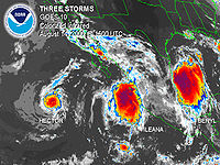
In the middle of August, two tropical storms developed off the Mexican coastline. Hector became a hurricane and moved out to sea, and Ileana became a strong tropical storm that neared, but never made landfall on the Mexican coastline. Hector formed southwest of Mexico, moved westward and dissipated over colder water southwest of Baja California. The remnants of Hector passed over the Hawaiian Islands several days later, producing heavy rain over most of the island chain.Tropical Storm Ileana
Ileana was a strong tropical storm that briefly threatened the southwest coast of mainland Mexico and the southern tip of the Baja California peninsula before abruptly turning away from Baja California and dissipating over open water.Tropical Storm Wene
A tropical disturbance developed in the Western Pacific Ocean along the eastern periphery of the monsoon trough in mid-August. Located at 33º north, it steadily organized, and became Tropical Depression Sixteen-W on August 15 while located 1,700 miles (2745.9 km) to the northwest of Honolulu, HawaiiHonolulu, Hawaii
Honolulu is the capital and the most populous city of the U.S. state of Hawaii. Honolulu is the southernmost major U.S. city. Although the name "Honolulu" refers to the urban area on the southeastern shore of the island of Oahu, the city and county government are consolidated as the City and...
. It moved eastward along the west-east oriented surface pressure trough, and crossed the International Date Line
International Date Line
The International Date Line is a generally north-south imaginary line on the surface of the Earth, passing through the middle of the Pacific Ocean, that designates the place where each calendar day begins...
later on August 15. Abnormally warm sea surface temperatures allowed the system to intensify despite its unusually high latitude, and it became Tropical Storm Wene on August 16. It quickly attained a peak intensity of 50 mph (85 km/h), but weakened due to colder sea surface temperatures and wind shear. Wene continued to weaken, and dissipated when the storm merged with an extratropical cyclone.
As a depression, Wene was the first, and currently is the most recent Western Pacific tropical cyclone to cross the dateline since the 1996 season
1996 Pacific hurricane season
The 1996 Pacific hurricane season was an event in tropical cyclone formation and the third least active Pacific hurricane season in recorded history, behind 1977 and 2010. It officially began May 15, 1996 in the eastern north Pacific and on June 1, 1996 in the central north Pacific. It ended on...
. The name Wene is Hawaiian
Hawaiian language
The Hawaiian language is a Polynesian language that takes its name from Hawaii, the largest island in the tropical North Pacific archipelago where it developed. Hawaiian, along with English, is an official language of the state of Hawaii...
for "Wayne".
Tropical Storm John
John originated on August 28 from an area of disturbed weather that was associated with the intertropical convergence zoneIntertropical Convergence Zone
The Intertropical Convergence Zone , known by sailors as The Doldrums, is the area encircling the earth near the equator where winds originating in the northern and southern hemispheres come together....
(ITCZ) near just outside the Central Pacific basin. Developing near the Central Pacific basin, John eventually entered early on August 30 and was then also monitored by the Central Pacific Hurricane Center
Central Pacific Hurricane Center
The Central Pacific Hurricane Center of the United States National Weather Service is the official body responsible for tracking and issuing tropical cyclone warnings, watches, advisories, discussions, and statements for the Central North Pacific Basin...
. that was a tropical storm for several days and moved from the eastern to the central Pacific basin. Thereafter entering the central Pacific region, Tropical Storm John approached hurricane status while meandering erratically east-southeast of Hawaii. John eventually encountered strong wind shear, and dissipated on September 1. Tropical Storm John did not cause any damage or fatalities, as there were no reports of any land being affect.
Tropical Storm Kristy
Part of the same tropical wave that spawned Tropical Storm Chris in the AtlanticAtlantic Ocean
The Atlantic Ocean is the second-largest of the world's oceanic divisions. With a total area of about , it covers approximately 20% of the Earth's surface and about 26% of its water surface area...
uneventfully crossed the rest of the Atlantic and passed far out to sea into the Pacific before it organized into Tropical Depression Fourteen-E on August 31. Despite significant shear, the depression strengthened into Tropical Storm Kristy as it meandered far from land over the open ocean. The shear then destroyed the system on September 3 where it was at a place just 210 kilometers from where it first organized. There were no effects anywhere.
Hurricane Lane
The precursor to Lane was a tropical wave that formed in the Atlantic Ocean on August 20. The wave moved across the Atlantic basin without development and crossed Central America on August 29. By September 1, the system was beginning to organize south of Mexico. On September 4, the system became a tropical depression 140 miles (225 km) southwest of Manzanillo, Mexico. The next day the tropical depression became Tropical Storm Lane. After becoming a tropical storm, Lane executed a counter-clockwise loop, during that maneuver, the storm crossed its own wake and weakened slightly. After the storm finished the loop, it continued to move westward where it reached hurricane strength on September 9 while passing over Socorro IslandSocorro Island
Socorro Island is a small volcanic island in the Revillagigedo Islands, a Mexican possession lying some 600 kilometers off the country's western coast at 18°48'N, 110°59'W. The size is 16.5 by 11.5 km, with an area of 132 km².- Geology :...
. By September 11, Lane encountered cooler waters which weakened the hurricane back to tropical storm strength. Lane then encountered a trough
Trough (meteorology)
A trough is an elongated region of relatively low atmospheric pressure, often associated with fronts.Unlike fronts, there is not a universal symbol for a trough on a weather chart. The weather charts in some countries or regions mark troughs by a line. In the United States, a trough may be marked...
that had formed off the western United States
United States
The United States of America is a federal constitutional republic comprising fifty states and a federal district...
coastline. The interaction with the system caused Lane to curve northeast towards the West Coast of the United States
West Coast of the United States
West Coast or Pacific Coast are terms for the westernmost coastal states of the United States. The term most often refers to the states of California, Oregon, and Washington. Although not part of the contiguous United States, Alaska and Hawaii do border the Pacific Ocean but can't be included in...
. On September 13, Lane passed over cooler waters, causing it to weaken to a tropical depression. Lane then dissipated on the next day.
On September 9, forecasters predicted that the storm would remain offshore and its rainbands would bring heavy rains and gusty winds across the Baja California
Baja California
Baja California officially Estado Libre y Soberano de Baja California is one of the 31 states which, with the Federal District, comprise the 32 Federal Entities of Mexico. It is both the northernmost and westernmost state of Mexico. Before becoming a state in 1953, the area was known as the North...
. However, because forecasters predicted that the storm would stay offshore, and so no warnings or watches were issued. Lane passed directly over Socorro Island
Socorro Island
Socorro Island is a small volcanic island in the Revillagigedo Islands, a Mexican possession lying some 600 kilometers off the country's western coast at 18°48'N, 110°59'W. The size is 16.5 by 11.5 km, with an area of 132 km².- Geology :...
where a weather station recorded a pressure of 973 mb. Although the center of Lane was well offshore, it still brought heavy surf that closed several ports in Mexico. In an Jose del Cabo, Mexico, a weather station reported winds of 32 mph (52 km/h). Lane remnants then affected the Western United States
Western United States
.The Western United States, commonly referred to as the American West or simply "the West," traditionally refers to the region comprising the westernmost states of the United States. Because the U.S. expanded westward after its founding, the meaning of the West has evolved over time...
. The moisture from Lane produced thunderstorms in northern California
California
California is a state located on the West Coast of the United States. It is by far the most populous U.S. state, and the third-largest by land area...
. At all locations, effects were minimal, with no reports of damage or casualties.
Tropical Storm Miriam
A tropical wave moved off the coast of Africa on August 29. It remained weak as it moved westward across the Atlantic Ocean, and entered the Pacific Ocean on September 9. As it moved west-northwestward, it organized, and developed into Tropical Depression Fifteen-E on September 15 while 290 miles (466.7 km) east-southeast of Cabo San LucasCabo San Lucas
Cabo San Lucas , commonly called Cabo, is a city at the southern tip of the Baja California peninsula, in the municipality of Los Cabos in the Mexican state of Baja California Sur. As of the 2010 census, the population was 68,463 people...
, Baja California Sur
Baja California Sur
Baja California Sur , is one of the 31 states which, with the Federal District, comprise the 32 Federal Entities of Mexico. Before becoming a state on October 8, 1974, the area was known as the South Territory of Baja California. It has an area of , or 3.57% of the land mass of Mexico and comprises...
. Banding features became more pronounced, though convection remained intermittent. On September 16, the depression briefly became Tropical Storm Miriam, though quickly weakened back to a tropical depression as it continued north-northwestward. Miriam dissipated on September 17 while 70 miles (112.6 km) northeast of Cabo San Lucas. Tropical storm force winds were never reported, and it is possible Miriam never attained tropical storm status.
Miriam dropped lighter than average rainfall upon Mexico, peaking at 7.68 in (195.1 mm) at La Cruz/Elota. Total damages from the storm amounted to $7.2 million (MXN
Mexican peso
The peso is the currency of Mexico. Modern peso and dollar currencies have a common origin in the 15th–19th century Spanish dollar, most continuing to use its sign, "$". The Mexican peso is the 12th most traded currency in the world, the third most traded in the Americas, and by far the most...
; $558,000 2000 USD, $ USD). By October 24, a national disaster declaration was signed for areas affected by Tropical Storm Miriam in Baja California Sur.
Tropical Storm Norman
The same tropical wave that spawned Atlantic Hurricane GordonHurricane Gordon (2000)
Hurricane Gordon was one of two U.S. landfalling tropical storms of the 2000 Atlantic hurricane season, and was the 7th named storm and 4th hurricane of the 2000 Atlantic hurricane season. Gordon was a category 1 hurricane over the Gulf of Mexico but weakened to a tropical storm before making...
organized into an area of low pressure in the Eastern Pacific Ocean on September 18. Its convection slowly organized while south of Mexico, and a tropical depression formed on September 20 while 205 miles (330 km) south-southeast of Manzanillo, Colima. Weak steering currents forced the depression to drift slowly northward, and later on September 20 it strengthened into Tropical Storm Norman. Norman quickly reached peak winds of 50 mph (85 km/h) before making landfall in western Mexico. The storm rapidly weakened to a tropical depression over land, but Norman maintained its circulation and some deep convection as it turned to the northwest. It emerged over water on September 22, but turned to the northeast, made landfall again in Mexico, and dissipated later that day.
Norman produced heavy rainfall across western Mexico, peaking at nearly 16 in (406.4 mm) in the state of Colima. In all, Norman caused $13.3 million (2000 USD; $ USD) in damage.
Tropical Storm Olivia
Olivia was a tropical storm that formed off the southwest coast of mainland Mexico, and generally tracked west-northwestward and remained over open water. After dissipating as a tropical cyclone, the remnant low-level circulation tracked across central Baja California, northwest Mexico and the desert southwest United States.Tropical Storm Paul
An area of disturbed weather emerged from the intertropical convergence zoneIntertropical Convergence Zone
The Intertropical Convergence Zone , known by sailors as The Doldrums, is the area encircling the earth near the equator where winds originating in the northern and southern hemispheres come together....
(ITCZ) on October 22. Located several hundred miles south-southeast of the Gulf of Tehuantepec
Gulf of Tehuantepec
Gulf of Tehuantepec is a large body of water on the Pacific coast of the Isthmus of Tehuantepec, southeastern Mexico, at . Most of the hurricanes that form in the Eastern Pacific organize in or near this body of water...
, convection gradually organized and increased, and by October 25 satellite images indicated the development of the eighteenth tropical depression of the season. Operationally it was not classified until 15 hours later. The depression moved westward throughout its duration, and based on Dvorak estimates, intensified into Tropical Storm Paul on October 26. Despite increasing wind shear ahead of the storm, the National Hurricane Center predicted steady intensification to near hurricane status, although Paul only attained peak winds of 45 mph (75 km/h).
As the wind shear increased and its convection became disorganized, Paul weakened. It briefly turned to the northwest due to a trough
Trough (meteorology)
A trough is an elongated region of relatively low atmospheric pressure, often associated with fronts.Unlike fronts, there is not a universal symbol for a trough on a weather chart. The weather charts in some countries or regions mark troughs by a line. In the United States, a trough may be marked...
, before resuming its westward motion. Although the convection was becoming displaced from the low-level circulation, the National Hurricane Center continued to predict strengthening. However, the thunderstorms became minimal, and Paul weakened to tropical depression status early on October 28. The circulation center deteriorated, and although there were occasional brief increases in convection, Paul dissipated early on October 29, as it was becoming indistinguishable in the ITCZ. The remnants continued westward, and interacted with an upper-level low, affecting Hawaii with heavy rainfall in early November 2000. The flooding caused $70 million (2000 USD; $ USD) in damage, and the highest rainfall total was 38.76 in (984.5 mm) at Kapapala Ranch. That rainfall total makes Paul Hawaii's second rainiest tropical cyclone, behind only Hurricane Hiki
Hurricane Hiki
Hurricane Hiki was the wettest tropical cyclone on record in the United States. The fourth tropical cyclone of the 1950 Pacific hurricane season, Hiki formed from a tropical depression that was first observed to the southeast of Hawaii on August 12...
of 1950.
Tropical Storm Rosa
The origins of Tropical Storm Rosa can be traced to a tropical wave that moved off the coast of Africa on October 18. It showed signs of development in the southwestern Caribbean Sea, though moved into the East Pacific Ocean on November 1 before being able to develop further. Favorable conditions allowed the system to quickly organize, and the wave formed into Tropical Depression Nineteen-E on November 3 while 230 mi (370 km) south of the El SalvadorEl Salvador
El Salvador or simply Salvador is the smallest and the most densely populated country in Central America. The country's capital city and largest city is San Salvador; Santa Ana and San Miguel are also important cultural and commercial centers in the country and in all of Central America...
– Guatemala
Guatemala
Guatemala is a country in Central America bordered by Mexico to the north and west, the Pacific Ocean to the southwest, Belize to the northeast, the Caribbean to the east, and Honduras and El Salvador to the southeast...
border. A ridge of high pressure to its north forced the depression westward, where it slowly organized into a tropical storm on November 5. A mid-level trough eroded the high pressure system, allowing Rosa to turn more to the north. On November 6, the storm reached a peak of 65 mph (100 km/h), though Rosa slowly weakened as it accelerated to the northeast. On November 8, the storm made landfall on the southern coast of Mexico with winds of 40 mph (65 km/h), and quickly dissipated.
Rosa dropped moderate rainfall across Mexico, peaking at 15.32 in (389 mm) near the Mexico/Guatemala border. Damage was minimal, totaling to only $15,000 (2000 USD; $ USD). Rosa was the first November storm since Hurricane Rick
Hurricane Rick (1997)
Hurricane Rick was the last hurricane in the 1997 Pacific hurricane season, the last named storm to form in the eastern Pacific, the second-last named storm of the season, and the second latest hurricane ever to make landfall in Mexico. Rick was a short-lived Category 2 hurricane on the...
in the 1997 season
1997 Pacific hurricane season
The 1997 Pacific hurricane season was a very active hurricane season. With hundreds of deaths and billions of dollars in damage, this season was the costliest and one of the deadliest Pacific hurricane seasons. This was due to a strong El Niño...
.
Storm names
The following names were used for named storms that formed in the eastern Pacific in 2000. Names that were not assigned are marked in gray. No names were retired, so it was used again in the 2006 Pacific hurricane season2006 Pacific hurricane season
The 2006 Pacific hurricane season was the most active Pacific hurricane season since 2000 producing 19 tropical storms or hurricanes. Eighteen developed within the National Hurricane Center area of warning responsibility, which is east of 140ºW, and one storm formed between 140ºW and the...
. This is the same list used for the 1994 season
1994 Pacific hurricane season
The 1994 Pacific hurricane season officially started on May 15, 1994 in the eastern Pacific, and on June 1, 1994 in the central Pacific, and lasted until November 30, 1994. These dates conventionally delimit the period of each year when most tropical cyclones form in the northeastern Pacific Ocean...
.
|
Tropical Storm Norman (2000) Tropical Storm Norman was a tropical cyclone that hit Mexico in September 2000. The sixteenth cyclone and fourteenth named storm of the 2000 Pacific hurricane season, Norman originated in a tropical wave that emerged from the coast of Africa on September 4, and moved westward across the Atlantic... |
|
Two names were used from the Central Pacific list — Upana and Wene.
See also
- List of Pacific hurricanes
- List of Pacific hurricane seasons
- 2000 Atlantic hurricane season2000 Atlantic hurricane seasonThe 2000 Atlantic hurricane season was the first season without a tropical cyclone in July since 1987. The season officially began on June 1, 2000, and lasted until November 30, 2000. The June through November dates conventionally delimit the period of each year when most tropical cyclones form in...
- 2000 Pacific typhoon season2000 Pacific typhoon seasonThe 2000 Pacific typhoon season has no official bounds; it ran year-round in 2000, but most tropical cyclones tend to form in the northwestern Pacific Ocean between May and November...
- 2000 North Indian Ocean cyclone season2000 North Indian Ocean cyclone seasonThe 2000 North Indian Ocean cyclone season had no bounds, but cyclones tend to form between April and December, with peaks in May and November. These dates conventionally delimit the period of each year when most tropical cyclones form in the northern Indian Ocean.-Season summary:Six tropical...
- South-West Indian Ocean cyclone seasons: 1999–00, 2000–01
- Australian region cyclone seasons: 1999–00, 2000–012000–01 Australian region cyclone seasonThe 2000–01 Australian region cyclone season was an event in the ongoing cycle of tropical cyclone formation. It began on 1 November 2000 and ended on 30 April 2001...
- South Pacific cyclone seasons: 1999–00, 2000–01