
1948 Atlantic hurricane season
Encyclopedia
The 1948 Atlantic hurricane season officially began on June 15, 1948, and lasted until November 15, 1948. These dates conventionally delimit the period of each year when most tropical cyclone
s form in the Atlantic basin
.
The 1948 Atlantic hurricane season
featured nine tropical cyclones; six storms attained hurricane status, and four storms intensified to major hurricanes
with winds of at least Category 3 intensity. Operationally, ten tropical disturbances were noted; a weak tropical disturbance formed over the southeast Bahamas
in May and moved northwest into the Georgia
coast near Savannah
, producing winds of 30 miles per hour (48.3 km/h).
formed during the latter half of the season, and the number of intense hurricanes surpassed the average of two. The season featured one tropical storm in May, and it was among eighteen tropical systems which formed during that month in the Atlantic basin
. Of the ten tropical disturbances detected operationally, five struck the United States with winds of 39 miles per hour (62.8 km/h) or greater, while the other tropical systems affected islands, remained over the open ocean, or affected the country with winds below tropical storm intensity. Three hurricanes made landfall in the United States, while the three other storms with winds of at least 74 mph (120 km/h) largely remained at sea.
The strongest storms of the season attained Category 4 intensity
; two of the major hurricanes formed in the western Caribbean Sea
and affected the United States in late September and October. A minimal hurricane struck southern Louisiana
, causing tides of five feet and winds of 78 miles per hour (125.5 km/h) in New Orleans
. A minimal tropical storm made landfall near Destin
in July. An intense hurricane attained Category 4 strength and produced extensive damage and 100 miles per hour (160.9 km/h) wind gusts on Bermuda
in mid-September. A Category 3 hurricane struck the southern portion of Florida
, resulting in $12 million of damages in the state. After the passage of one week, another hurricane affected the region as a Category 3 storm, after crossing Cuba
with winds of 135 miles per hour (217.3 km/h). Only three direct fatalities occurred in the United States
, largely because of improved evacuations and adherence to warnings and advisories.
developed into a weak tropical storm early on May 22. The circulation moved northeast, and it made landfall in southwest Haiti
with winds of 40 miles per hour (64.4 km/h) during the morning hours. The system crossed the island
and maintained its intensity as it entered the southwest Atlantic
. On May 24, the tropical cyclone slowly intensified, and it began to gradually turn to the north. Within a few hours, the storm attained its estimated peak intensity of 50 miles per hour (80.5 km/h), as reported by reconnaissance aircraft
. On May 25, the storm's forward motion slowed to a crawl, and the cyclone started to weaken on May 26. On May 27, the system began to accelerate northward, and it gained extratropical
characteristics. The system diminished to a tropical depression on May 28 shortly prior to dissipation 800 miles (1,287.5 km) east of Delaware
.
The tropical system brought widespread precipitation to Hispaniola, and widespread flooding took place across the region. 80 people died during the events, though other impacts are unknown, however this storm still ranks as the deadliest Atlantic storm to form in the off-season. The storm was one of only two May tropical storms to affect Guantanamo Bay.
. The area organized to a 40 miles per hour (64.4 km/h) tropical storm on July 11, and the system maintained its intensity as it moved to the northeast on July 8. The weak tropical system made landfall east of Pensacola
on July 9, and it quickly weakened to a depression as it moved inland. The remnants moved north through southeastern Alabama
on July 10, and the circulation dissipated over southern Tennessee
on July 11.
The system produced minimal effects along the Florida Panhandle
. Winds of 35 miles per hour (56.3 km/h) were measured at Pensacola during the passage of a thunderstorm
, and the tropical cyclone caused heavy precipitation
over northern Florida
, southern Alabama, and southern Georgia
. Overall damage was minimal.
, as ship reports indicated winds of Force 9
. The tropical cyclone quickly intensified to a hurricane, and it continued to steadily progress northwest. The storm strengthened to a Category 2 hurricane
on August 27, and it continued to intensify until it attained its estimated peak intensity of 120 miles per hour (193.1 km/h) on August 28. Its forward motion slowed on August 29, and it began to weaken as it turned to the north 250 miles (402.3 km) south of Hatteras
on August 30. The tropical system weakened to a minimal hurricane, and it accelerated to the northeast on August 31. The storm soon became extratropical, and the remnants dissipated east of southern Greenland
on September 4.
In anticipation of the storm, the U.S. Weather Bureau posted hurricane warnings
from Wilmington
to Cape Hatteras
. On August 30, as the tropical cyclone began to turn to the north, the center was expected to pass over or near Cape Hatteras. The hurricane caused high tides on the North Carolina
coastline, which prompted evacuations and precautions in the area. No damages or fatalities were reported.
, as a ship reported high easterly seas and winds of Force 10
. The small system moved steadily to the west, and it slowly weakened to a marginal tropical cyclone on August 31. On the morning of September 1, the circulation passed between Saint Lucia and Martinique
, when a reconnaissance aircraft
mission reported a minimum pressure of 1007 mbar (29.73 inHg). Subsequent missions failed to detect a center of circulation, and the tropical cyclone quickly degenerated to a tropical depression. It dissipated over the eastern Caribbean Sea
.
The short-lived tropical storm resulted in no reports of damages, and heavy precipitation affected the islands. The rainfall was beneficial, notably in Puerto Rico
; water supplies and crops were replenished. Minor flooding occurred on the islands and caused minimal damage.
. On the morning of September 2, the poorly defined center moved northeast, and the tropical cyclone gradually intensified. It attained hurricane intensity on September 3, and it slowly accelerated toward the upper Gulf Coast
. It rapidly reached its peak intensity of 80 miles per hour (128.7 km/h), and it crossed the coastline near Grand Isle
around midnight on September 4. The center moved inland over Orleans Parish
, and the weakening tropical cyclone diminished to a strong tropical storm prior to moving over southern Mississippi
. It continued to weaken as it approached Hattiesburg
on September 5, and it moved over the area with winds of 40 miles per hour (64.4 km/h). The remnants turned to the north, and the circulation dissipated over northwestern Indiana
on September 6.
On September 4, the U.S. Weather Bureau advised residents that the storm was expected to strike land between Morgan City
and Grand Isle around midnight, as its forward motion had increased to 15 miles per hour (24.1 km/h). The weather service also noted that abnormally high tides were expected from the Mississippi River
to Pensacola
, as the center was predicted to pass east of New Orleans and move to the west of Biloxi
shortly before dawn. 1,000 people left their homes in Terrebonne Parish
and took shelter in a courthouse and school buildings in Houma
. As winds increased, city officials in New Orleans ordered 2,000 people to evacuate from a wartime housing project
into an auditorium for shelter. The hurricane produced gusts of 78 miles per hour (125.5 km/h) at Moisant Airport
, and tides ranged from 6 to 3.4 feet (1 m) along the coast from Mississippi to the Florida Panhandle
. The maximum tide reached 4.7 feet (1.4 m) in New Orleans, and winds caused damage to small boats, trees, and power and communication lines. At Grand Isle, the heaviest damage occurred to oil rigs and drilling equipment from high tides. Total damage in the United States reached $900,000, but no loss of life was reported.
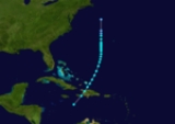
that formed from a tropical wave off Africa on September 3 and rapidly strengthened into a hurricane. It moved steadily west-northwest across the Atlantic, gradually strengthening. The storm became a major hurricane while northeast of the Windward Islands
. It began to make a broad curve to the north over a three-day period. During that period, the storm continued to strengthen, peaking at Category 4 strength with winds of 135 miles per hour (217.3 km/h). Shortly after, the hurricane passed almost directly over Bermuda, bringing 100+ mph (160 km/h) winds to the island. Damage was heavy but no figures currently exist. No people are known to have died. The hurricane continued north and curved gently to the northeast, passing south of Cape Race, Newfoundland before becoming extratropical.
developed into a tropical storm on September 18. It moved northwestward, hitting Cuba
south of Havana
on September 20. It strengthened to a major hurricane the next day, hit the Florida Keys
, and made landfall near Everglades City, Florida
on September 21. It weakened over Florida, and turned northeast, becoming extratropical on September 24. The hurricane was responsible for $12 million in damage (1948 dollars) and 3 deaths in Florida and 10 deaths and "several million dollars" in damage in Cuba.
on October 5 and early on October 6. Weakening over land, the hurricane passed just south of Bermuda, weakened to a tropical storm, looped northward, and dissipated on October 16. The hurricane caused $11 million in damage (1948 dollars) and 11 casualties.
with minimal effects before degenerating into a squall line off the Virginia
coast early on November 11.
The table on the right shows the ACE
for each storm in the season. ACE is, broadly speaking, a measure of the power of the hurricane multiplied by the length of time it existed, so storms that last a long time, as well as particularly strong hurricanes, have high ACEs. ACE is only officially released for full advisories on tropical systems at or exceeding 34 knots (39 miles per hour (62.8 km/h) or tropical storm strength. Subtropical storms are not included in season totals.
Tropical cyclone
A tropical cyclone is a storm system characterized by a large low-pressure center and numerous thunderstorms that produce strong winds and heavy rain. Tropical cyclones strengthen when water evaporated from the ocean is released as the saturated air rises, resulting in condensation of water vapor...
s form in the Atlantic basin
Atlantic Basin
The Atlantic Basin is the Atlantic Ocean.Atlantic Basin may also refer to:* Atlantic Basin Iron Works, an ironworks that operated in Brooklyn, New York, in the early to mid-20th century...
.
The 1948 Atlantic hurricane season
Atlantic hurricane season
The Atlantic hurricane season is the period in a year when hurricanes usually form in the Atlantic Ocean. Tropical cyclones in the North Atlantic are called hurricanes, tropical storms, or tropical depressions. In addition, there have been several storms over the years that have not been fully...
featured nine tropical cyclones; six storms attained hurricane status, and four storms intensified to major hurricanes
Saffir-Simpson Hurricane Scale
The Saffir–Simpson Hurricane Scale , or the Saffir–Simpson Hurricane Wind Scale , classifies hurricanes — Western Hemisphere tropical cyclones that exceed the intensities of tropical depressions and tropical storms — into five categories distinguished by the intensities of their sustained winds...
with winds of at least Category 3 intensity. Operationally, ten tropical disturbances were noted; a weak tropical disturbance formed over the southeast Bahamas
The Bahamas
The Bahamas , officially the Commonwealth of the Bahamas, is a nation consisting of 29 islands, 661 cays, and 2,387 islets . It is located in the Atlantic Ocean north of Cuba and Hispaniola , northwest of the Turks and Caicos Islands, and southeast of the United States...
in May and moved northwest into the Georgia
Georgia (U.S. state)
Georgia is a state located in the southeastern United States. It was established in 1732, the last of the original Thirteen Colonies. The state is named after King George II of Great Britain. Georgia was the fourth state to ratify the United States Constitution, on January 2, 1788...
coast near Savannah
Savannah, Georgia
Savannah is the largest city and the county seat of Chatham County, in the U.S. state of Georgia. Established in 1733, the city of Savannah was the colonial capital of the Province of Georgia and later the first state capital of Georgia. Today Savannah is an industrial center and an important...
, producing winds of 30 miles per hour (48.3 km/h).
Season summary
The 1948 Atlantic hurricane season was slightly below average, and it featured a total of nine storms, which fell below the climatological seasonal average of ten. All of the hurricanesTropical cyclone
A tropical cyclone is a storm system characterized by a large low-pressure center and numerous thunderstorms that produce strong winds and heavy rain. Tropical cyclones strengthen when water evaporated from the ocean is released as the saturated air rises, resulting in condensation of water vapor...
formed during the latter half of the season, and the number of intense hurricanes surpassed the average of two. The season featured one tropical storm in May, and it was among eighteen tropical systems which formed during that month in the Atlantic basin
Atlantic Basin
The Atlantic Basin is the Atlantic Ocean.Atlantic Basin may also refer to:* Atlantic Basin Iron Works, an ironworks that operated in Brooklyn, New York, in the early to mid-20th century...
. Of the ten tropical disturbances detected operationally, five struck the United States with winds of 39 miles per hour (62.8 km/h) or greater, while the other tropical systems affected islands, remained over the open ocean, or affected the country with winds below tropical storm intensity. Three hurricanes made landfall in the United States, while the three other storms with winds of at least 74 mph (120 km/h) largely remained at sea.
The strongest storms of the season attained Category 4 intensity
Saffir-Simpson Hurricane Scale
The Saffir–Simpson Hurricane Scale , or the Saffir–Simpson Hurricane Wind Scale , classifies hurricanes — Western Hemisphere tropical cyclones that exceed the intensities of tropical depressions and tropical storms — into five categories distinguished by the intensities of their sustained winds...
; two of the major hurricanes formed in the western Caribbean Sea
Caribbean Sea
The Caribbean Sea is a sea of the Atlantic Ocean located in the tropics of the Western hemisphere. It is bounded by Mexico and Central America to the west and southwest, to the north by the Greater Antilles, and to the east by the Lesser Antilles....
and affected the United States in late September and October. A minimal hurricane struck southern Louisiana
Louisiana
Louisiana is a state located in the southern region of the United States of America. Its capital is Baton Rouge and largest city is New Orleans. Louisiana is the only state in the U.S. with political subdivisions termed parishes, which are local governments equivalent to counties...
, causing tides of five feet and winds of 78 miles per hour (125.5 km/h) in New Orleans
New Orleans, Louisiana
New Orleans is a major United States port and the largest city and metropolitan area in the state of Louisiana. The New Orleans metropolitan area has a population of 1,235,650 as of 2009, the 46th largest in the USA. The New Orleans – Metairie – Bogalusa combined statistical area has a population...
. A minimal tropical storm made landfall near Destin
Destin, Florida
Destin is a city located in Okaloosa County, Florida. It is a principal city of the Fort Walton Beach-Crestview-Destin, Florida Metropolitan Statistical Area.Located on Florida's Emerald Coast, Destin is known for its white beaches and emerald green waters...
in July. An intense hurricane attained Category 4 strength and produced extensive damage and 100 miles per hour (160.9 km/h) wind gusts on Bermuda
Bermuda
Bermuda is a British overseas territory in the North Atlantic Ocean. Located off the east coast of the United States, its nearest landmass is Cape Hatteras, North Carolina, about to the west-northwest. It is about south of Halifax, Nova Scotia, Canada, and northeast of Miami, Florida...
in mid-September. A Category 3 hurricane struck the southern portion of Florida
Florida Keys
The Florida Keys are a coral archipelago in southeast United States. They begin at the southeastern tip of the Florida peninsula, about south of Miami, and extend in a gentle arc south-southwest and then westward to Key West, the westernmost of the inhabited islands, and on to the uninhabited Dry...
, resulting in $12 million of damages in the state. After the passage of one week, another hurricane affected the region as a Category 3 storm, after crossing Cuba
Cuba
The Republic of Cuba is an island nation in the Caribbean. The nation of Cuba consists of the main island of Cuba, the Isla de la Juventud, and several archipelagos. Havana is the largest city in Cuba and the country's capital. Santiago de Cuba is the second largest city...
with winds of 135 miles per hour (217.3 km/h). Only three direct fatalities occurred in the United States
United States
The United States of America is a federal constitutional republic comprising fifty states and a federal district...
, largely because of improved evacuations and adherence to warnings and advisories.
Tropical Storm One
Ten days preceding the start of the season, a broad area of low pressure in the central Caribbean SeaCaribbean Sea
The Caribbean Sea is a sea of the Atlantic Ocean located in the tropics of the Western hemisphere. It is bounded by Mexico and Central America to the west and southwest, to the north by the Greater Antilles, and to the east by the Lesser Antilles....
developed into a weak tropical storm early on May 22. The circulation moved northeast, and it made landfall in southwest Haiti
Haiti
Haiti , officially the Republic of Haiti , is a Caribbean country. It occupies the western, smaller portion of the island of Hispaniola, in the Greater Antillean archipelago, which it shares with the Dominican Republic. Ayiti was the indigenous Taíno or Amerindian name for the island...
with winds of 40 miles per hour (64.4 km/h) during the morning hours. The system crossed the island
Hispaniola
Hispaniola is a major island in the Caribbean, containing the two sovereign states of the Dominican Republic and Haiti. The island is located between the islands of Cuba to the west and Puerto Rico to the east, within the hurricane belt...
and maintained its intensity as it entered the southwest Atlantic
Atlantic Ocean
The Atlantic Ocean is the second-largest of the world's oceanic divisions. With a total area of about , it covers approximately 20% of the Earth's surface and about 26% of its water surface area...
. On May 24, the tropical cyclone slowly intensified, and it began to gradually turn to the north. Within a few hours, the storm attained its estimated peak intensity of 50 miles per hour (80.5 km/h), as reported by reconnaissance aircraft
Surveillance aircraft
A surveillance aircraft is an aircraft used for surveillance — collecting information over time. They are operated by military forces and other government agencies in roles such as intelligence gathering, battlefield surveillance, airspace surveillance, observation , border patrol and fishery...
. On May 25, the storm's forward motion slowed to a crawl, and the cyclone started to weaken on May 26. On May 27, the system began to accelerate northward, and it gained extratropical
Extratropical cyclone
Extratropical cyclones, sometimes called mid-latitude cyclones or wave cyclones, are a group of cyclones defined as synoptic scale low pressure weather systems that occur in the middle latitudes of the Earth having neither tropical nor polar characteristics, and are connected with fronts and...
characteristics. The system diminished to a tropical depression on May 28 shortly prior to dissipation 800 miles (1,287.5 km) east of Delaware
Delaware
Delaware is a U.S. state located on the Atlantic Coast in the Mid-Atlantic region of the United States. It is bordered to the south and west by Maryland, and to the north by Pennsylvania...
.
The tropical system brought widespread precipitation to Hispaniola, and widespread flooding took place across the region. 80 people died during the events, though other impacts are unknown, however this storm still ranks as the deadliest Atlantic storm to form in the off-season. The storm was one of only two May tropical storms to affect Guantanamo Bay.
Tropical Storm Two
After nearly two months of inactivity, an area of disturbed weather developed in the northern Gulf of MexicoGulf of Mexico
The Gulf of Mexico is a partially landlocked ocean basin largely surrounded by the North American continent and the island of Cuba. It is bounded on the northeast, north and northwest by the Gulf Coast of the United States, on the southwest and south by Mexico, and on the southeast by Cuba. In...
. The area organized to a 40 miles per hour (64.4 km/h) tropical storm on July 11, and the system maintained its intensity as it moved to the northeast on July 8. The weak tropical system made landfall east of Pensacola
Pensacola, Florida
Pensacola is the westernmost city in the Florida Panhandle and the county seat of Escambia County, Florida, United States of America. As of the 2000 census, the city had a total population of 56,255 and as of 2009, the estimated population was 53,752...
on July 9, and it quickly weakened to a depression as it moved inland. The remnants moved north through southeastern Alabama
Alabama
Alabama is a state located in the southeastern region of the United States. It is bordered by Tennessee to the north, Georgia to the east, Florida and the Gulf of Mexico to the south, and Mississippi to the west. Alabama ranks 30th in total land area and ranks second in the size of its inland...
on July 10, and the circulation dissipated over southern Tennessee
Tennessee
Tennessee is a U.S. state located in the Southeastern United States. It has a population of 6,346,105, making it the nation's 17th-largest state by population, and covers , making it the 36th-largest by total land area...
on July 11.
The system produced minimal effects along the Florida Panhandle
Florida Panhandle
The Florida Panhandle, an informal, unofficial term for the northwestern part of Florida, is a strip of land roughly 200 miles long and 50 to 100 miles wide , lying between Alabama on the north and the west, Georgia also on the north, and the Gulf of Mexico to the south. Its eastern boundary is...
. Winds of 35 miles per hour (56.3 km/h) were measured at Pensacola during the passage of a thunderstorm
Thunderstorm
A thunderstorm, also known as an electrical storm, a lightning storm, thundershower or simply a storm is a form of weather characterized by the presence of lightning and its acoustic effect on the Earth's atmosphere known as thunder. The meteorologically assigned cloud type associated with the...
, and the tropical cyclone caused heavy precipitation
Precipitation (meteorology)
In meteorology, precipitation In meteorology, precipitation In meteorology, precipitation (also known as one of the classes of hydrometeors, which are atmospheric water phenomena is any product of the condensation of atmospheric water vapor that falls under gravity. The main forms of precipitation...
over northern Florida
Florida
Florida is a state in the southeastern United States, located on the nation's Atlantic and Gulf coasts. It is bordered to the west by the Gulf of Mexico, to the north by Alabama and Georgia and to the east by the Atlantic Ocean. With a population of 18,801,310 as measured by the 2010 census, it...
, southern Alabama, and southern Georgia
Georgia (U.S. state)
Georgia is a state located in the southeastern United States. It was established in 1732, the last of the original Thirteen Colonies. The state is named after King George II of Great Britain. Georgia was the fourth state to ratify the United States Constitution, on January 2, 1788...
. Overall damage was minimal.
Hurricane Able
After one month of inactivity, the first hurricane of the season formed in late August. This system was named Able by the Air Weather Service in real-time. A 60 miles per hour (96.6 km/h) tropical storm formed on August 26 600 miles (965.6 km) northeast of Saint JohnSaint John, U.S. Virgin Islands
Saint John is an island in the Caribbean Sea and a constituent district of the United States Virgin Islands , an unincorporated territory of the United States. St...
, as ship reports indicated winds of Force 9
Beaufort scale
The Beaufort Scale is an empirical measure that relates wind speed to observed conditions at sea or on land. Its full name is the Beaufort Wind Force Scale.-History:...
. The tropical cyclone quickly intensified to a hurricane, and it continued to steadily progress northwest. The storm strengthened to a Category 2 hurricane
Saffir-Simpson Hurricane Scale
The Saffir–Simpson Hurricane Scale , or the Saffir–Simpson Hurricane Wind Scale , classifies hurricanes — Western Hemisphere tropical cyclones that exceed the intensities of tropical depressions and tropical storms — into five categories distinguished by the intensities of their sustained winds...
on August 27, and it continued to intensify until it attained its estimated peak intensity of 120 miles per hour (193.1 km/h) on August 28. Its forward motion slowed on August 29, and it began to weaken as it turned to the north 250 miles (402.3 km) south of Hatteras
Hatteras, North Carolina
Hatteras is an unincorporated community in Dare County, North Carolina, United States, on the Outer Banks island of Hatteras. North Carolina Highway 12 passes through the community linking it to Frisco and Ocracoke . It is south of the famous Cape Hatteras and the Cape Hatteras Lighthouse in Buxton...
on August 30. The tropical system weakened to a minimal hurricane, and it accelerated to the northeast on August 31. The storm soon became extratropical, and the remnants dissipated east of southern Greenland
Greenland
Greenland is an autonomous country within the Kingdom of Denmark, located between the Arctic and Atlantic Oceans, east of the Canadian Arctic Archipelago. Though physiographically a part of the continent of North America, Greenland has been politically and culturally associated with Europe for...
on September 4.
In anticipation of the storm, the U.S. Weather Bureau posted hurricane warnings
Tropical cyclone warnings and watches
Warnings and watches are two levels of alert issued by national weather forecasting bodies to coastal areas threatened by the imminent approach of a tropical cyclone of tropical storm or hurricane intensity. They are notices to the local population and civil authorities to make appropriate...
from Wilmington
Wilmington, North Carolina
Wilmington is a port city in and is the county seat of New Hanover County, North Carolina, United States. The population is 106,476 according to the 2010 Census, making it the eighth most populous city in the state of North Carolina...
to Cape Hatteras
Cape Hatteras
Cape Hatteras is a cape on the coast of North Carolina. It is the point that protrudes the farthest to the southeast along the northeast-to-southwest line of the Atlantic coast of North America...
. On August 30, as the tropical cyclone began to turn to the north, the center was expected to pass over or near Cape Hatteras. The hurricane caused high tides on the North Carolina
North Carolina
North Carolina is a state located in the southeastern United States. The state borders South Carolina and Georgia to the south, Tennessee to the west and Virginia to the north. North Carolina contains 100 counties. Its capital is Raleigh, and its largest city is Charlotte...
coastline, which prompted evacuations and precautions in the area. No damages or fatalities were reported.
Tropical Storm Four
The season's activity increased during late August. Four days after the formation of Hurricane Three, a 60 miles per hour (96.6 km/h) tropical storm was detected on August 30 450 miles (724.2 km) east of Saint LuciaSaint Lucia
Saint Lucia is an island country in the eastern Caribbean Sea on the boundary with the Atlantic Ocean. Part of the Lesser Antilles, it is located north/northeast of the island of Saint Vincent, northwest of Barbados and south of Martinique. It covers a land area of 620 km2 and has an...
, as a ship reported high easterly seas and winds of Force 10
Beaufort scale
The Beaufort Scale is an empirical measure that relates wind speed to observed conditions at sea or on land. Its full name is the Beaufort Wind Force Scale.-History:...
. The small system moved steadily to the west, and it slowly weakened to a marginal tropical cyclone on August 31. On the morning of September 1, the circulation passed between Saint Lucia and Martinique
Martinique
Martinique is an island in the eastern Caribbean Sea, with a land area of . Like Guadeloupe, it is an overseas region of France, consisting of a single overseas department. To the northwest lies Dominica, to the south St Lucia, and to the southeast Barbados...
, when a reconnaissance aircraft
Surveillance aircraft
A surveillance aircraft is an aircraft used for surveillance — collecting information over time. They are operated by military forces and other government agencies in roles such as intelligence gathering, battlefield surveillance, airspace surveillance, observation , border patrol and fishery...
mission reported a minimum pressure of 1007 mbar (29.73 inHg). Subsequent missions failed to detect a center of circulation, and the tropical cyclone quickly degenerated to a tropical depression. It dissipated over the eastern Caribbean Sea
Caribbean Sea
The Caribbean Sea is a sea of the Atlantic Ocean located in the tropics of the Western hemisphere. It is bounded by Mexico and Central America to the west and southwest, to the north by the Greater Antilles, and to the east by the Lesser Antilles....
.
The short-lived tropical storm resulted in no reports of damages, and heavy precipitation affected the islands. The rainfall was beneficial, notably in Puerto Rico
Puerto Rico
Puerto Rico , officially the Commonwealth of Puerto Rico , is an unincorporated territory of the United States, located in the northeastern Caribbean, east of the Dominican Republic and west of both the United States Virgin Islands and the British Virgin Islands.Puerto Rico comprises an...
; water supplies and crops were replenished. Minor flooding occurred on the islands and caused minimal damage.
Hurricane Five
As the peak of hurricane season arrived, an area of disturbed weather organized to a 39 miles per hour (62.8 km/h) tropical storm on September 1 over the southern Gulf of MexicoGulf of Mexico
The Gulf of Mexico is a partially landlocked ocean basin largely surrounded by the North American continent and the island of Cuba. It is bounded on the northeast, north and northwest by the Gulf Coast of the United States, on the southwest and south by Mexico, and on the southeast by Cuba. In...
. On the morning of September 2, the poorly defined center moved northeast, and the tropical cyclone gradually intensified. It attained hurricane intensity on September 3, and it slowly accelerated toward the upper Gulf Coast
Gulf Coast of the United States
The Gulf Coast of the United States, sometimes referred to as the Gulf South, South Coast, or 3rd Coast, comprises the coasts of American states that are on the Gulf of Mexico, which includes Texas, Louisiana, Mississippi, Alabama, and Florida and are known as the Gulf States...
. It rapidly reached its peak intensity of 80 miles per hour (128.7 km/h), and it crossed the coastline near Grand Isle
Grand Isle, Louisiana
Grand Isle is a town in Jefferson Parish, Louisiana, located on a barrier island of the same name in the Gulf of Mexico. The island is at the mouth of Barataria Bay where it meets the gulf. As of the 2000 census, the town population was 1,541; during summers, the population sometimes increases to...
around midnight on September 4. The center moved inland over Orleans Parish
New Orleans, Louisiana
New Orleans is a major United States port and the largest city and metropolitan area in the state of Louisiana. The New Orleans metropolitan area has a population of 1,235,650 as of 2009, the 46th largest in the USA. The New Orleans – Metairie – Bogalusa combined statistical area has a population...
, and the weakening tropical cyclone diminished to a strong tropical storm prior to moving over southern Mississippi
Mississippi
Mississippi is a U.S. state located in the Southern United States. Jackson is the state capital and largest city. The name of the state derives from the Mississippi River, which flows along its western boundary, whose name comes from the Ojibwe word misi-ziibi...
. It continued to weaken as it approached Hattiesburg
Hattiesburg, Mississippi
Hattiesburg is a city in Forrest County, Mississippi, United States. The population was 44,779 at the 2000 census . It is the county seat of Forrest County...
on September 5, and it moved over the area with winds of 40 miles per hour (64.4 km/h). The remnants turned to the north, and the circulation dissipated over northwestern Indiana
Indiana
Indiana is a US state, admitted to the United States as the 19th on December 11, 1816. It is located in the Midwestern United States and Great Lakes Region. With 6,483,802 residents, the state is ranked 15th in population and 16th in population density. Indiana is ranked 38th in land area and is...
on September 6.
On September 4, the U.S. Weather Bureau advised residents that the storm was expected to strike land between Morgan City
Morgan City, Louisiana
Morgan City is a city in St. Martin and St. Mary parishes in the U.S. state of Louisiana. The population was 12,404 at the 2010 census....
and Grand Isle around midnight, as its forward motion had increased to 15 miles per hour (24.1 km/h). The weather service also noted that abnormally high tides were expected from the Mississippi River
Mississippi River
The Mississippi River is the largest river system in North America. Flowing entirely in the United States, this river rises in western Minnesota and meanders slowly southwards for to the Mississippi River Delta at the Gulf of Mexico. With its many tributaries, the Mississippi's watershed drains...
to Pensacola
Pensacola, Florida
Pensacola is the westernmost city in the Florida Panhandle and the county seat of Escambia County, Florida, United States of America. As of the 2000 census, the city had a total population of 56,255 and as of 2009, the estimated population was 53,752...
, as the center was predicted to pass east of New Orleans and move to the west of Biloxi
Biloxi, Mississippi
Biloxi is a city in Harrison County, Mississippi, in the United States. The 2010 census recorded the population as 44,054. Along with Gulfport, Biloxi is a county seat of Harrison County....
shortly before dawn. 1,000 people left their homes in Terrebonne Parish
Terrebonne Parish, Louisiana
Terrebonne Parish is a parish located in the U.S. state of Louisiana. The parish seat is Houma. Its population was 111,860...
and took shelter in a courthouse and school buildings in Houma
Houma, Louisiana
Houma is a city in and the parish seat of Terrebonne Parish, Louisiana, and the largest principal city of the Houma–Bayou Cane–Thibodaux Metropolitan Statistical Area. The city's powers of government have been absorbed by the parish, which is now run by the Terrebonne Parish...
. As winds increased, city officials in New Orleans ordered 2,000 people to evacuate from a wartime housing project
World War II
World War II, or the Second World War , was a global conflict lasting from 1939 to 1945, involving most of the world's nations—including all of the great powers—eventually forming two opposing military alliances: the Allies and the Axis...
into an auditorium for shelter. The hurricane produced gusts of 78 miles per hour (125.5 km/h) at Moisant Airport
Louis Armstrong New Orleans International Airport
Louis Armstrong New Orleans International Airport is a Class B public use international airport in Jefferson Parish, Louisiana, United States. It is owned by the City of New Orleans and is located 10 nautical miles west of its central business district. The airport's address is 900 Airline Drive...
, and tides ranged from 6 to 3.4 feet (1 m) along the coast from Mississippi to the Florida Panhandle
Florida Panhandle
The Florida Panhandle, an informal, unofficial term for the northwestern part of Florida, is a strip of land roughly 200 miles long and 50 to 100 miles wide , lying between Alabama on the north and the west, Georgia also on the north, and the Gulf of Mexico to the south. Its eastern boundary is...
. The maximum tide reached 4.7 feet (1.4 m) in New Orleans, and winds caused damage to small boats, trees, and power and communication lines. At Grand Isle, the heaviest damage occurred to oil rigs and drilling equipment from high tides. Total damage in the United States reached $900,000, but no loss of life was reported.
Hurricane Six
Storm Six was a Cape Verde-type hurricaneCape Verde-type hurricane
A Cape Verde-type hurricane is an Atlantic hurricane that develops near the Cape Verde islands, off the west coast of Africa. The average hurricane season has about two Cape Verde-type hurricanes, which are usually the largest and most intense storms of the season because they often have plenty of...
that formed from a tropical wave off Africa on September 3 and rapidly strengthened into a hurricane. It moved steadily west-northwest across the Atlantic, gradually strengthening. The storm became a major hurricane while northeast of the Windward Islands
Windward Islands
The Windward Islands are the southern islands of the Lesser Antilles, within the West Indies.-Name and geography:The Windward Islands are called such because they were more windward to sailing ships arriving in the New World than the Leeward Islands, given that the prevailing trade winds in the...
. It began to make a broad curve to the north over a three-day period. During that period, the storm continued to strengthen, peaking at Category 4 strength with winds of 135 miles per hour (217.3 km/h). Shortly after, the hurricane passed almost directly over Bermuda, bringing 100+ mph (160 km/h) winds to the island. Damage was heavy but no figures currently exist. No people are known to have died. The hurricane continued north and curved gently to the northeast, passing south of Cape Race, Newfoundland before becoming extratropical.
Hurricane Seven
A tropical wave in the northwestern Caribbean SeaCaribbean Sea
The Caribbean Sea is a sea of the Atlantic Ocean located in the tropics of the Western hemisphere. It is bounded by Mexico and Central America to the west and southwest, to the north by the Greater Antilles, and to the east by the Lesser Antilles....
developed into a tropical storm on September 18. It moved northwestward, hitting Cuba
Cuba
The Republic of Cuba is an island nation in the Caribbean. The nation of Cuba consists of the main island of Cuba, the Isla de la Juventud, and several archipelagos. Havana is the largest city in Cuba and the country's capital. Santiago de Cuba is the second largest city...
south of Havana
Havana
Havana is the capital city, province, major port, and leading commercial centre of Cuba. The city proper has a population of 2.1 million inhabitants, and it spans a total of — making it the largest city in the Caribbean region, and the most populous...
on September 20. It strengthened to a major hurricane the next day, hit the Florida Keys
Florida Keys
The Florida Keys are a coral archipelago in southeast United States. They begin at the southeastern tip of the Florida peninsula, about south of Miami, and extend in a gentle arc south-southwest and then westward to Key West, the westernmost of the inhabited islands, and on to the uninhabited Dry...
, and made landfall near Everglades City, Florida
Everglades, Florida
Everglades is a city in Collier County, Florida, United States. The population was 479 at the 2000 census. As of 2004, the population recorded by the U.S. Census Bureau is 513...
on September 21. It weakened over Florida, and turned northeast, becoming extratropical on September 24. The hurricane was responsible for $12 million in damage (1948 dollars) and 3 deaths in Florida and 10 deaths and "several million dollars" in damage in Cuba.
Hurricane Eight
A tropical storm formed in the Western Caribbean Sea on October 3. It turned northward, hitting western Cuba on October 5 as a major hurricane, an area recently affected by the previous hurricane two weeks ago. It continued northeastward, reaching a peak of 135 miles per hour (217.3 km/h) winds before hitting the Florida Keys and southwest FloridaFlorida
Florida is a state in the southeastern United States, located on the nation's Atlantic and Gulf coasts. It is bordered to the west by the Gulf of Mexico, to the north by Alabama and Georgia and to the east by the Atlantic Ocean. With a population of 18,801,310 as measured by the 2010 census, it...
on October 5 and early on October 6. Weakening over land, the hurricane passed just south of Bermuda, weakened to a tropical storm, looped northward, and dissipated on October 16. The hurricane caused $11 million in damage (1948 dollars) and 11 casualties.
Hurricane Nine
The final storm of the season formed in early November over the open ocean southwest of Bermuda and made a curve to the north while slowly strengthening. The storm peaked with 80 mi/h winds before the center began to fall apart. The weakening storm passed by the Outer BanksOuter Banks
The Outer Banks is a 200-mile long string of narrow barrier islands off the coast of North Carolina, beginning in the southeastern corner of Virginia Beach on the east coast of the United States....
with minimal effects before degenerating into a squall line off the Virginia
Virginia
The Commonwealth of Virginia , is a U.S. state on the Atlantic Coast of the Southern United States. Virginia is nicknamed the "Old Dominion" and sometimes the "Mother of Presidents" after the eight U.S. presidents born there...
coast early on November 11.
Accumulated Cyclone Energy (ACE) rating
| ACE (104kt²) (Source) — Storm: | |||||||||||||
|---|---|---|---|---|---|---|---|---|---|---|---|---|---|
| 1 | 35.9875 | Six | 6 | 3.8 | One | ||||||||
| 2 | 20.66 | Eight | 7 | 3.755 | Nine | ||||||||
| 3 | 17.5825 | Seven | 8 | 1.145 | Four | ||||||||
| 4 | 17.53 | Three | 9 | 0.98 | Two | ||||||||
| 5 | 4.62 | Five | |||||||||||
| Total: 106.06 | |||||||||||||
The table on the right shows the ACE
Accumulated cyclone energy
Accumulated cyclone energy is a measure used by the National Oceanic and Atmospheric Administration to express the activity of individual tropical cyclones and entire tropical cyclone seasons, particularly the North Atlantic hurricane season. It uses an approximation of the energy used by a...
for each storm in the season. ACE is, broadly speaking, a measure of the power of the hurricane multiplied by the length of time it existed, so storms that last a long time, as well as particularly strong hurricanes, have high ACEs. ACE is only officially released for full advisories on tropical systems at or exceeding 34 knots (39 miles per hour (62.8 km/h) or tropical storm strength. Subtropical storms are not included in season totals.
See also
- List of tropical cyclones
- List of Atlantic hurricane seasons