

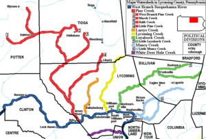
West Branch Susquehanna Valley
Encyclopedia
Pennsylvania
The Commonwealth of Pennsylvania is a U.S. state that is located in the Northeastern and Mid-Atlantic regions of the United States. The state borders Delaware and Maryland to the south, West Virginia to the southwest, Ohio to the west, New York and Ontario, Canada, to the north, and New Jersey to...
, United States
United States
The United States of America is a federal constitutional republic comprising fifty states and a federal district...
, in the Ridge-and-valley Appalachians
Ridge-and-valley Appalachians
The Ridge-and-Valley Appalachians, also called the Ridge and Valley Province or the Valley and Ridge Appalachians, are a physiographic province of the larger Appalachian division and are also a belt within the Appalachian Mountains extending from southeastern New York through northwestern New...
, is the low lying area draining into the West Branch Susquehanna River
West Branch Susquehanna River
The West Branch Susquehanna River is one of the two principal branches, along with the North Branch, of the Susquehanna River in the northeastern United States. The North Branch, which rises in upstate New York, is generally regarded as the extension of the main branch, with the shorter West Branch...
southeast of the Allegheny Front
Allegheny Front
The Allegheny Front is the major southeast- or east-facing escarpment in the Allegheny Mountains in southern Pennsylvania, western Maryland, and eastern West Virginia, USA. The Allegheny Front delineates the Ridge-and-Valley Appalachians to its east from the Appalachian Plateau to its west...
, northeast of the Bald Eagle Valley
Bald Eagle Valley
The Bald Eagle Valley of central Pennsylvania, United States is the low lying area draining into the Bald Eagle Creek between the Allegheny Front and the Bald Eagle Mountain ridge, south of the West Branch Susquehanna River, in the Ridge-and-valley Appalachians...
, southwest of the Wyoming Valley
Wyoming Valley
Wyoming Valley is a region of northeastern Pennsylvania. As a metropolitan area, it is also known as the Scranton/Wilkes-Barre area, after its principal cities, Scranton and Wilkes-Barre....
and nort of the water gap
Water gap
A water gap is an opening or notch which flowing water has carved through a mountain range. Water gaps often offer a practical route for road and rail transport to cross mountain ridges.- Geology :...
formed between Shamokin Mountain and Montour Ridge.
The river enters the valley after emerging from a deep gorge in the Allegheny Plateau
Allegheny Plateau
The Allegheny Plateau is a large dissected plateau area in western and central New York, northern and western Pennsylvania, northern and western West Virginia, and eastern Ohio...
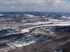
above Lock Haven
Lock Haven, Pennsylvania
The city of Lock Haven is the county seat of Clinton County, in the U.S. state of Pennsylvania. Located near the confluence of the West Branch Susquehanna River and Bald Eagle Creek, it is the principal city of the Lock Haven, Pennsylvania, micropolitan statistical area, itself part of the...
, then turns east entering a broad alluvial flood plain, where it receives the Bald Eagle Creek
Bald Eagle Creek (West Branch Susquehanna River)
Bald Eagle Creek is a tributary of the West Branch Susquehanna River mostly in Centre County, Pennsylvania, in the United States. It runs through the Bald Eagle Valley at the foot of the Bald Eagle Mountain ridge to Lock Haven....
after passing the town. The flood plain lies at the foot of the Bald Eagle Mountain
Bald Eagle Mountain
Bald Eagle Mountain, once known locally as Muncy Mountain, is a stratigraphic ridge in central Pennsylvania, United States, running east of the Allegheny Front and northwest of Mount Nittany. It lies along the southeast side of Bald Eagle Creek, and south of the West Branch Susquehanna River, and...
ridge, with large fertile farm fields in and around the river's meander
Meander
A meander in general is a bend in a sinuous watercourse. A meander is formed when the moving water in a stream erodes the outer banks and widens its valley. A stream of any volume may assume a meandering course, alternately eroding sediments from the outside of a bend and depositing them on the...
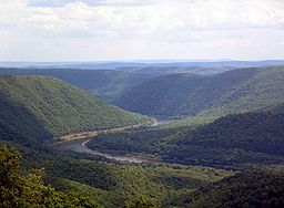
s and islands. The valley above the flood plain is a series of knolls below the plateau. Further down the valley, the river receives Pine Creek
Pine Creek
Pine Creek may refer to:*In California, USA**Big Pine Creek **Pine Creek, former name of New Pine Creek, California** Pine Creek, *In Colorado, USA**Pine Creek High School**Pine Creek Golf Course...
which has also entered the valley from a deep gorge, Pine Creek Gorge
Pine Creek Gorge
Pine Creek Gorge, also known as, The Grand Canyon of Pennsylvania, is situated in approximately 160,000 acres of the Tioga State Forest in the U.S. State of Pennsylvania along Pine Creek. The Canyon begins south of Ansonia, near Wellsboro, along U.S. Route 6 and continues for approximately...
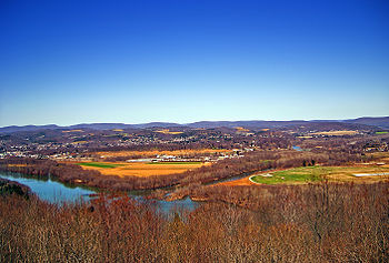
(also known as the Grand Canyon of Pennsylvania). East of Williamsport
Williamsport, Pennsylvania
Williamsport is a city in and the county seat of Lycoming County, Pennsylvania in the United States. In 2009, the population was estimated at 29,304...
, the Bald Eagle ridge ends, the river turns south, and the valley opens up and follows the river to the water gap at Lewisburg
Lewisburg, Pennsylvania
Lewisburg is a borough in Union County, Pennsylvania, United States, south by southeast of Williamsport and north of Harrisburg. In the past, it was the commercial center for a fertile grain and general farming region. The population was 5,620 at the 2000 census. It is the county seat of Union...
.
In Clinton
Clinton County, Pennsylvania
As of the census of 2000, there were 37,914 people, 14,773 households, and 9,927 families residing in the county. The population density was 43 people per square mile . There were 18,166 housing units at an average density of 20 per square mile...
and Lycoming
Lycoming County, Pennsylvania
-Appalachian Mountains and Allegheny Plateau:Lycoming County is divided between the Appalachian Mountains in the south, the dissected Allegheny Plateau in the north and east, and the valley of the West Branch Susquehanna River between these.-West Branch Susquehanna River:The West Branch of the...
Counties, it is northeast of the Bald Eagle Valley
Bald Eagle Valley
The Bald Eagle Valley of central Pennsylvania, United States is the low lying area draining into the Bald Eagle Creek between the Allegheny Front and the Bald Eagle Mountain ridge, south of the West Branch Susquehanna River, in the Ridge-and-valley Appalachians...
and runs from Lock Haven
Lock Haven, Pennsylvania
The city of Lock Haven is the county seat of Clinton County, in the U.S. state of Pennsylvania. Located near the confluence of the West Branch Susquehanna River and Bald Eagle Creek, it is the principal city of the Lock Haven, Pennsylvania, micropolitan statistical area, itself part of the...
to Williamsport
Williamsport, Pennsylvania
Williamsport is a city in and the county seat of Lycoming County, Pennsylvania in the United States. In 2009, the population was estimated at 29,304...
.
History
The lands along the West Branch were vital hunting grounds and agricultural lands for Native AmericansNative Americans in the United States
Native Americans in the United States are the indigenous peoples in North America within the boundaries of the present-day continental United States, parts of Alaska, and the island state of Hawaii. They are composed of numerous, distinct tribes, states, and ethnic groups, many of which survive as...
. During Pennsylvania’s great lumbering era, the most significant log drive was conveyed on the West Branch of the Susquehanna River. The Susquehanna’s West Branch Canal
Canal
Canals are man-made channels for water. There are two types of canal:#Waterways: navigable transportation canals used for carrying ships and boats shipping goods and conveying people, further subdivided into two kinds:...
Division further shaped the corridor, linking towns and villages and providing vital opportunities for commerce. Finally, railroads
Rail transport
Rail transport is a means of conveyance of passengers and goods by way of wheeled vehicles running on rail tracks. In contrast to road transport, where vehicles merely run on a prepared surface, rail vehicles are also directionally guided by the tracks they run on...
in the corridor fused the links between communities and commerce within the corridor. http://www.dcnr.state.pa.us/brc/rivers/riversconservation/registry/64Sec1.pdf
Otstonwakin
Madame Montour's village of Otstonwakin or Ostuagy was a vitally important location during the settlement of what is now Lycoming County. Her village at the mouth of Loyalsock CreekLoyalsock Creek
Loyalsock Creek is a tributary of the West Branch Susquehanna River located chiefly in Sullivan and Lycoming counties in Pennsylvania in the United States...
on the West Branch Susquehanna River was an important stopping point for the Moravian missionaries who were spreading the gospel
Gospel
A gospel is an account, often written, that describes the life of Jesus of Nazareth. In a more general sense the term "gospel" may refer to the good news message of the New Testament. It is primarily used in reference to the four canonical gospels of Matthew, Mark, Luke, and John...
throughout the wilderness of Pennsylvania during the 1740s. Count Zinzendorf, a missionary being guided by Conrad Weiser
Conrad Weiser
Weiser's colonial service began in 1731. The Iroquois sent Shikellamy, an Oneida chief, as an emissary to other tribes and the British. Shikellamy lived on the Susquehanna River at Shamokin village, near present-day Sunbury, Pennsylvania. An oral tradition holds that Weiser met Shikellamy while...
with the permission of Shikellamy
Shikellamy
Shikellamy , also known as Swatana, was an Oneida chief and overseer for the Iroquois confederacy. In his position as chief and overseer, Shikellamy served as a supervisor for the Six Nations, overseeing the Shawnee and Lenape tribes in central Pennsylvania along the Susquehanna River and...
came to Ostuagy in 1742.
Early inhabitants
The first recorded inhabitants of the West Branch Susquehanna River valley were the IroquoianIroquoian languages
The Iroquoian languages are a First Nation and Native American language family.-Family division:*Ruttenber, Edward Manning. 1992 [1872]. History of the Indian tribes of Hudson's River. Hope Farm Press....
speaking Susquehannock
Susquehannock
The Susquehannock people were Iroquoian-speaking Native Americans who lived in areas adjacent to the Susquehanna River and its tributaries from the southern part of what is now New York, through Pennsylvania, to the mouth of the Susquehanna in Maryland at the north end of the Chesapeake Bay...
s. Their name meant "people of the muddy river" in Algonquian
Algonquian languages
The Algonquian languages also Algonkian) are a subfamily of Native American languages which includes most of the languages in the Algic language family. The name of the Algonquian language family is distinguished from the orthographically similar Algonquin dialect of the Ojibwe language, which is a...
. Decimated by diseases and warfare, they had died out, moved away, or been assimilated
Cultural assimilation
Cultural assimilation is a socio-political response to demographic multi-ethnicity that supports or promotes the assimilation of ethnic minorities into the dominant culture. The term assimilation is often used with regard to immigrants and various ethnic groups who have settled in a new land. New...
into other tribes by the early 18th century. The lands of the West Branch Susquehanna River Valley were then chiefly occupied by the Munsee phratry
Phratry
In ancient Greece, a phratry ατρία, "brotherhood", "kinfolk", derived from φρατήρ meaning "brother") was a social division of the Greek tribe...
of the Lenape
Lenape
The Lenape are an Algonquian group of Native Americans of the Northeastern Woodlands. They are also called Delaware Indians. As a result of the American Revolutionary War and later Indian removals from the eastern United States, today the main groups live in Canada, where they are enrolled in the...
(or Delaware), and were under the nominal control of the Five (later Six) Nations of the Iroquois
Iroquois
The Iroquois , also known as the Haudenosaunee or the "People of the Longhouse", are an association of several tribes of indigenous people of North America...
.
The British
United Kingdom
The United Kingdom of Great Britain and Northern IrelandIn the United Kingdom and Dependencies, other languages have been officially recognised as legitimate autochthonous languages under the European Charter for Regional or Minority Languages...
purchased land from the Iroquois in the Treaty of Fort Stanwix
Treaty of Fort Stanwix
The Treaty of Fort Stanwix was an important treaty between North American Indians and the British Empire. It was signed in 1768 at Fort Stanwix, located in present-day Rome, New York...
of 1768, opening what is now Lycoming County to settlement. However, the Line of Property
Line of Property
The Line of Property is the name commonly given to the line dividing Indian from British Colonial lands established in the Treaty of Fort Stanwix of 1768...
(or Purchase Line
Purchase line
The Purchase Line is the name commonly given to the line dividing Indian from British Colonial lands established in the Treaty of Fort Stanwix of 1768 in western Pennsylvania...
) border defined by "Tiadaghton Creek" dividing colonial and Native American lands was disputed. The colonists claimed this was Pine Creek
Pine Creek (Pennsylvania)
Pine Creek is a tributary of the West Branch Susquehanna River in Potter, Tioga, Lycoming, and Clinton counties in Pennsylvania in the United States. The creek is long...
, the Iroquois and other tribes Lycoming Creek
Lycoming Creek
Lycoming Creek is a tributary of the West Branch Susquehanna River located in Tioga and Lycoming counties in Pennsylvania in the United States.-Geography:...
. The area between Pine and Lycoming Creeks was disputed territory. The illegal settlers there were part of the "Fair Play Men
Fair Play Men
The Fair Play Men were illegal settlers who established their own system of self-rule from 1773 to 1785 in the West Branch Susquehanna River valley of Pennsylvania in what is now the United States. Because they settled in territory claimed by Native Americans, they had no recourse to the...
" system of self-government, with their own Declaration of Independence from Britain on July 4, 1776.
American Revolutionary War
The American Revolutionary War , the American War of Independence, or simply the Revolutionary War, began as a war between the Kingdom of Great Britain and thirteen British colonies in North America, and ended in a global war between several European great powers.The war was the result of the...
, settlements throughout the Susquehanna valley were attacked by Loyalist
Loyalist (American Revolution)
Loyalists were American colonists who remained loyal to the Kingdom of Great Britain during the American Revolutionary War. At the time they were often called Tories, Royalists, or King's Men. They were opposed by the Patriots, those who supported the revolution...
s and Native Americans allied with the British. After the Wyoming Valley battle and massacre in the summer of 1778 (near what is now Wilkes-Barre
Wilkes-Barre, Pennsylvania
Wilkes-Barre is a city in the U.S. state of Pennsylvania, the county seat of Luzerne County. It is at the center of the Wyoming Valley area and is one of the principal cities in the Scranton/Wilkes-Barre metropolitan area, which had a population of 563,631 as of the 2010 Census...
) and smaller local attacks, the "Big Runaway
Big Runaway
The Big Runaway occurred in 1778, during the American Revolutionary War, when settlements throughout the West Branch Susquehanna Valley in Pennsylvania in what became the United States were attacked by Loyalists and Native Americans allied with the British...
" occurred throughout the West Branch Susquehanna valley. Settlers fled feared and actual attacks by the British and their allies. Homes and fields were abandoned, with livestock driven along and a few possessions floated on rafts on the river east to Muncy
Muncy, Pennsylvania
For other places named 'Muncy', please see Muncy .Muncy is a borough in Lycoming County, Pennsylvania, in the United States. The name Muncy comes from the Munsee Indians who once lived in the area. The population was 2,663 at the 2000 census. It is part of the Williamsport, Pennsylvania...
, then further south to Sunbury
Sunbury, Pennsylvania
Sunbury is a city in Northumberland County, Pennsylvania, United States. The city is located on the east bank of the Susquehanna River, just downstream of the confluence of its main and West branches. The population was 9,905 at the 2010 census...
. The abandoned property was burnt by the attackers. Some settlers soon returned, only to flee again in the summer of 1779 in the "Little Runaway". Sullivan's Expedition helped stabilize the area and encouraged resettlement, which continued after the war.
Fair Play Men
The Fair Play Men were illegal settlerSettler
A settler is a person who has migrated to an area and established permanent residence there, often to colonize the area. Settlers are generally people who take up residence on land and cultivate it, as opposed to nomads...
s (squatters) who established their own system of self-rule from 1773 to 1785 in the West Branch Susquehanna River
West Branch Susquehanna River
The West Branch Susquehanna River is one of the two principal branches, along with the North Branch, of the Susquehanna River in the northeastern United States. The North Branch, which rises in upstate New York, is generally regarded as the extension of the main branch, with the shorter West Branch...
valley of Pennsylvania
Pennsylvania
The Commonwealth of Pennsylvania is a U.S. state that is located in the Northeastern and Mid-Atlantic regions of the United States. The state borders Delaware and Maryland to the south, West Virginia to the southwest, Ohio to the west, New York and Ontario, Canada, to the north, and New Jersey to...
in what is now the United States
United States
The United States of America is a federal constitutional republic comprising fifty states and a federal district...
. Because they settled in territory claimed by Native Americans
Native Americans in the United States
Native Americans in the United States are the indigenous peoples in North America within the boundaries of the present-day continental United States, parts of Alaska, and the island state of Hawaii. They are composed of numerous, distinct tribes, states, and ethnic groups, many of which survive as...
, they had no recourse to the Pennsylvania colonial government. Accordingly they established what was known as the Fair Play System, with three elected commissioners who ruled on land claims and other issues for the group. In a remarkable coincidence, the Fair Play Men made their own Declaration of Independence
Declaration of independence
A declaration of independence is an assertion of the independence of an aspiring state or states. Such places are usually declared from part or all of the territory of another nation or failed nation, or are breakaway territories from within the larger state...
from Britain
United Kingdom
The United Kingdom of Great Britain and Northern IrelandIn the United Kingdom and Dependencies, other languages have been officially recognised as legitimate autochthonous languages under the European Charter for Regional or Minority Languages...
on July 4, 1776 beneath the "Tiadaghton Elm" on the banks of Pine Creek
Pine Creek (Pennsylvania)
Pine Creek is a tributary of the West Branch Susquehanna River in Potter, Tioga, Lycoming, and Clinton counties in Pennsylvania in the United States. The creek is long...
.
Fort Antes
Fort AntesFort Antes
Fort Antes was a stockade surrounding the home of Colonel John Henry Antes, built circa 1778 in Revolutionary Pennsylvania in the United States. The fort was built under the direction of Colonel Antes, who was a member of the Pennsylvania militia...
was a stockade
Stockade
A stockade is an enclosure of palisades and tall walls made of logs placed side by side vertically with the tops sharpened to provide security.-Stockade as a security fence:...
surrounding the home of Colonel John Henry Antes, built circa 1778 in Revolutionary
American Revolution
The American Revolution was the political upheaval during the last half of the 18th century in which thirteen colonies in North America joined together to break free from the British Empire, combining to become the United States of America...
Pennsylvania
Pennsylvania
The Commonwealth of Pennsylvania is a U.S. state that is located in the Northeastern and Mid-Atlantic regions of the United States. The state borders Delaware and Maryland to the south, West Virginia to the southwest, Ohio to the west, New York and Ontario, Canada, to the north, and New Jersey to...
in the United States
United States
The United States of America is a federal constitutional republic comprising fifty states and a federal district...
. The fort was built under the direction of Colonel Antes, who was a member of the Pennsylvania militia
Militia
The term militia is commonly used today to refer to a military force composed of ordinary citizens to provide defense, emergency law enforcement, or paramilitary service, in times of emergency without being paid a regular salary or committed to a fixed term of service. It is a polyseme with...
. It was on the east side of Antes Creek, overlooking and on the left bank of the West Branch Susquehanna River
West Branch Susquehanna River
The West Branch Susquehanna River is one of the two principal branches, along with the North Branch, of the Susquehanna River in the northeastern United States. The North Branch, which rises in upstate New York, is generally regarded as the extension of the main branch, with the shorter West Branch...
on a plateau
Plateau
In geology and earth science, a plateau , also called a high plain or tableland, is an area of highland, usually consisting of relatively flat terrain. A highly eroded plateau is called a dissected plateau...
in Nippenose Township south of modern day Jersey Shore
Jersey Shore, Pennsylvania
Jersey Shore is a borough in Lycoming County, Pennsylvania, United States. It is on the West Branch Susquehanna River, west by south of Williamsport. It is part of the Williamsport, Pennsylvania Metropolitan Statistical Area. In the past, Jersey Shore held farms, railroad shops, cigar factories, a...
in western Lycoming County
Lycoming County, Pennsylvania
-Appalachian Mountains and Allegheny Plateau:Lycoming County is divided between the Appalachian Mountains in the south, the dissected Allegheny Plateau in the north and east, and the valley of the West Branch Susquehanna River between these.-West Branch Susquehanna River:The West Branch of the...
. The local militia held the fort for a short period of time until it was ordered to abandon Fort Antes during the Big Runaway by Colonel Samuel Hunter. Despite being abandoned and attempts by the attacking British forces to burn it down, Fort Antes was one of only two structures in the valley to survive the Big Runaway.
Susquehanna Boom
The Susquehanna BoomSusquehanna Boom
The Susquehanna Boom was a system of cribs and chained logs in the West Branch Susquehanna River, designed to catch and hold floating timber until it could be processed at one of the nearly 60 sawmills along the river between Lycoming and Loyalsock Creeks in Lycoming County, Pennsylvania in the...
was a system of cribs in the West Branch Susquehanna River
West Branch Susquehanna River
The West Branch Susquehanna River is one of the two principal branches, along with the North Branch, of the Susquehanna River in the northeastern United States. The North Branch, which rises in upstate New York, is generally regarded as the extension of the main branch, with the shorter West Branch...
designed to hold timber
Timber
Timber may refer to:* Timber, a term common in the United Kingdom and Australia for wood materials * Timber, Oregon, an unincorporated community in the U.S...
in the river until it could be processed at one of the nearly 60 sawmill
Sawmill
A sawmill is a facility where logs are cut into boards.-Sawmill process:A sawmill's basic operation is much like those of hundreds of years ago; a log enters on one end and dimensional lumber exits on the other end....
s along the West Branch Susquehanna River between Lycoming
Lycoming Creek
Lycoming Creek is a tributary of the West Branch Susquehanna River located in Tioga and Lycoming counties in Pennsylvania in the United States.-Geography:...
and Loyalsock Creek
Loyalsock Creek
Loyalsock Creek is a tributary of the West Branch Susquehanna River located chiefly in Sullivan and Lycoming counties in Pennsylvania in the United States...
s in Lycoming County
Lycoming County, Pennsylvania
-Appalachian Mountains and Allegheny Plateau:Lycoming County is divided between the Appalachian Mountains in the south, the dissected Allegheny Plateau in the north and east, and the valley of the West Branch Susquehanna River between these.-West Branch Susquehanna River:The West Branch of the...
, Pennsylvania
Pennsylvania
The Commonwealth of Pennsylvania is a U.S. state that is located in the Northeastern and Mid-Atlantic regions of the United States. The state borders Delaware and Maryland to the south, West Virginia to the southwest, Ohio to the west, New York and Ontario, Canada, to the north, and New Jersey to...
in the United States
United States
The United States of America is a federal constitutional republic comprising fifty states and a federal district...
. The boom was constructed in 1846 under the supervision of James H. Perkins.
A boom is a chain or line of connected floating timbers extended across a river, lake, or harbor (as to obstruct passage or catch floating objects). The Susquehanna Boom extended seven miles upstream from Duboistown
Duboistown, Pennsylvania
Duboistown is a borough in Lycoming County, Pennsylvania, United States. The population was 1,280 at the 2000 census. It is part of the Williamsport, Pennsylvania Metropolitan Statistical Area.-History:...
to the village of Linden in Woodward Township
Woodward Township, Lycoming County, Pennsylvania
Woodward Township is a township in Lycoming County, Pennsylvania, in the United States. The population was 2,397 at the 2000 census. It is part of the Williamsport, Pennsylvania Metropolitan Statistical Area.-History:...
. The boom was constructed by creating a series of man-made islands known as "cribs". These cribs built of local mountain stone and sunken timber were stretched diagonally across the river, beginning on the south side near Duboistown and ending on the north side near Linden. The boom was made of 352 separate cribs that were 22 feet high. The boom was opened and closed at the upper end by a device known as a "sheer boom." It was 1,000 feet long and was controlled with a hand-powered windlass
Windlass
The windlass is an apparatus for moving heavy weights. Typically, a windlass consists of a horizontal cylinder , which is rotated by the turn of a crank or belt...
. The sheer boom gathered the logs into the main boom that was capable of holding up to 300 million board feet (8700,000 m³) of logs. The lower end of the boom was where the logs were sorted. The mills in Williamsport, South Williamsport
South Williamsport, Pennsylvania
South Williamsport is a borough in Lycoming County, Pennsylvania, United States. The population was 6,412 at the 2000 census. It is part of the Williamsport, Pennsylvania Metropolitan Statistical Area.-History:...
, and Duboistown each had their own distinctive brand burnt into the logs. The men working at the end of the boom would sort the logs according to their corresponding brand and float them into the correct holding pond along the bank of the river. During the height of the lumber industry in Lycoming County, 1861–1891, the various mills produced 5.5 billion board feet (13,000,000 m³) of lumber. Williamsport became one of the most prosperous cities in Pennsylvania and in the United States. Men like James H. Perkins, Peter Herdic
Peter Herdic
Peter Herdic was a lumber baron, entrepreneur, inventor, politician, and philanthropist in Victorian era Williamsport, Lycoming County, Pennsylvania in the United States. He was the youngest of seven children born to Henry and Elizabeth Herdic on December 14, 1824 in Fort Plain, New York. Herdic's...
, and Mahlon Fisher became millionaire
Millionaire
A millionaire is an individual whose net worth or wealth is equal to or exceeds one million units of currency. It can also be a person who owns one million units of currency in a bank account or savings account...
s while many of the men who actually worked in the river struggled to survive on the wages paid to them by the lumber barons.
Principal towns in the West Branch Susquehanna Valley
- Lock HavenLock Haven, PennsylvaniaThe city of Lock Haven is the county seat of Clinton County, in the U.S. state of Pennsylvania. Located near the confluence of the West Branch Susquehanna River and Bald Eagle Creek, it is the principal city of the Lock Haven, Pennsylvania, micropolitan statistical area, itself part of the...
- Jersey ShoreJersey Shore, PennsylvaniaJersey Shore is a borough in Lycoming County, Pennsylvania, United States. It is on the West Branch Susquehanna River, west by south of Williamsport. It is part of the Williamsport, Pennsylvania Metropolitan Statistical Area. In the past, Jersey Shore held farms, railroad shops, cigar factories, a...
- WilliamsportWilliamsport, PennsylvaniaWilliamsport is a city in and the county seat of Lycoming County, Pennsylvania in the United States. In 2009, the population was estimated at 29,304...
- MontoursvilleMontoursville, PennsylvaniaMontoursville is a borough in Lycoming County, Pennsylvania, in the United States. As of the 2000 census, the borough population was 4,777. It is part of the Williamsport, Pennsylvania Metropolitan Statistical Area. It was named for Madame Montour, a Native American leader and skilled interpreter...
- MuncyMuncy, PennsylvaniaFor other places named 'Muncy', please see Muncy .Muncy is a borough in Lycoming County, Pennsylvania, in the United States. The name Muncy comes from the Munsee Indians who once lived in the area. The population was 2,663 at the 2000 census. It is part of the Williamsport, Pennsylvania...
- MontgomeryMontgomery, PennsylvaniaMontgomery is a borough in Lycoming County, Pennsylvania, in the United States. The population was 1,695 at the 2000 census. It is part of the Williamsport, Pennsylvania Metropolitan Statistical Area.-History:...
- WatsontownWatsontown, PennsylvaniaWatsontown is a borough in Northumberland County, Pennsylvania, United States. The population was 2,255 at the 2000 census. It was named for John Watson, a local landowner.-Geography:Watsontown is located at ....
- MiltonMilton, PennsylvaniaMilton is a borough in Northumberland County, Pennsylvania, on the Susquehanna River, north of Harrisburg. Settled in 1770, it was incorporated in 1817, and is governed by a charter that was revised in 1890...
- LewisburgLewisburg, PennsylvaniaLewisburg is a borough in Union County, Pennsylvania, United States, south by southeast of Williamsport and north of Harrisburg. In the past, it was the commercial center for a fertile grain and general farming region. The population was 5,620 at the 2000 census. It is the county seat of Union...