
Loyalsock Creek
Encyclopedia
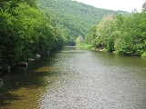
Loyalsock Creek is a 64 miles (103 km) tributary
of the West Branch Susquehanna River
located chiefly in Sullivan
and Lycoming
counties in Pennsylvania
in the United States
. As the crow flies
, Lycoming County is about 130 miles (209 km) northwest of Philadelphia and 165 miles (266 km) east-northeast of Pittsburgh.
meaning "middle creek" (the original was something like Lawi-sahquick). This refers to Loyalsock Creek's location between Lycoming Creek
and Muncy Creek
, with the mouths of each about 6 miles (10 km) up- and downstream of the mouth of the Loyalsock. Several important trails used by the local indigenous peoples ran along parts of the Loyalsock or crossed it. Two important villages of the local indigenous peoples were located on its banks, one of which, Ots-ton-wak-in, was the home to Madame Montour and her son Andrew Montour
, and later became Montoursville
.
near the Sullivan County line, and its confluence
with the West Branch Susquehanna River is at Montoursville. The area surrounding the confluence with the Susquehanna River has been flooded numerous times over the past decade, devastating many local homes and businesses.
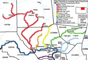 Its main tributary is Little Loyalsock Creek, which has its confluence at Forksville
in Sullivan County. The names of Forksville and the surrounding Forks Township
come from the fork of the creek there.
Pennsylvania receives the most acid rain
of any state in the United States. Because Loyalsock Creek is in a sandstone
, limestone
, shale
, conglomerate
, and coal
mountain region, it has a relatively low capacity to neutralize
added acid
. This makes it especially vulnerable to increased acidification from acid rain, which poses a long-term threat to the health of the plants and animals in the creek.
Loyalsock Creek is used for trout
fishing
and whitewater
kayak
ing, and the Loyalsock Trail
which runs along it is an opportunity for hiking
. Worlds End State Park
is located on the Loyalsock in Sullivan County, near Forksville. U.S. Route 220
runs through the Loyalsock valley.
in Sullivan County
. Geologically, they are a bed of quartz
sandstone
with an undulating upper surface, and are part of the Mississippian-Devonian
Upper Huntley Mountain Formation
.
was an important stopping point for the Moravian missionaries who were spreading the gospel throughout the wilderness of Pennsylvania
during the 1740s. Count Zinzendorf, a missionary being guided by Conrad Weiser
with the permission of Shikellamy
, came to Ostuagy in 1742.
Madame Montour was known to be a friend of the British. She welcomed the white men who were beginning to migrate into the West Branch Susquehanna Valley
. She also had a great amount of influence with the various Indian tribes that were feeling the pressure of colonial expansion. Madame Montour remained loyal to the British despite several attempts by the French to bring her over to their side. Historians note that this was remarkable due to the fact that the British colonial government sometimes went as long as a year without paying her for her services.
 Although lumbering was an important industry in the Loyalsock Creek watershed, railroads took little advantage of the creek valley below Forksville. One exception was the Susquehanna and Eagles Mere Railroad
, which built down into Hillsgrove and along the creek as far as Ogdonia in 1902, before turning up Kettle Creek. It was removed in 1922. Above Forksville, the Williamsport and North Branch Railroad
followed Mill Creek to reach the Loyalsock and followed it to a crossing at Ringdale. The line was built in 1893 and removed in 1938. About six miles (10 km) to the east, the town of Lopez is the largest settlement on the upper creek. Jennings Brothers Lumber Co. built a narrow-gauge logging line in the area in 1890, and another in 1891 up the creek into Wyoming County
, to supply their sawmill at Lopez. In 1892, the Loyalsock Railroad crossed the creek here, building south to bring coal from the Bernice area southward to Harvey's Lake. It was promptly leased to the Lehigh Valley Railroad
and became part of the Bowmans Creek Branch. At the same time, the Loyalsock Railroad also built a branch along the Loyalsock downstream from Lopez to Ellis Creek, where it turned south to reach a tannery at Thorndale. This branch was removed in 1898. However, Jennings Bros. continued to operate, standard-gauging their rail line about 1900 and building up the Loyalsock as far as Shumans Lake, where their line headed up Cold Run towards High Cobble and the Dutch Mountain area. The logging railroad was finally removed in 1905 when Jennings Bros. relocated to Maryland, but was partly resurrected in 1911. Stony Brook Lumber Co. used the old grade as far as Santee Run, then turned north towards Crane Swamp. This line was removed in 1916. Traffic gradually dwindled on the Lehigh Valley; their line south of Lopez was abandoned in 1939, and it was cut back to Bernice in 1944. This marked the end of rail traffic on the Loyalsock, except for the Reading Railroad crossing near its mouth at Montoursville. The bridge there is now owned by the Lycoming Valley Railroad
, but was rendered unusable by flooding from Tropical Storm Lee
in 2011.
Tributary
A tributary or affluent is a stream or river that flows into a main stem river or a lake. A tributary does not flow directly into a sea or ocean...
of the West Branch Susquehanna River
West Branch Susquehanna River
The West Branch Susquehanna River is one of the two principal branches, along with the North Branch, of the Susquehanna River in the northeastern United States. The North Branch, which rises in upstate New York, is generally regarded as the extension of the main branch, with the shorter West Branch...
located chiefly in Sullivan
Sullivan County, Pennsylvania
Sullivan County is a county located in the U.S. state of Pennsylvania. As of 2010, the population is 6,428. Sullivan County was created on March 15, 1847, from part of Lycoming County and named for Charles Sullivan, leader of the Pennsylvania Senate...
and Lycoming
Lycoming County, Pennsylvania
-Appalachian Mountains and Allegheny Plateau:Lycoming County is divided between the Appalachian Mountains in the south, the dissected Allegheny Plateau in the north and east, and the valley of the West Branch Susquehanna River between these.-West Branch Susquehanna River:The West Branch of the...
counties in Pennsylvania
Pennsylvania
The Commonwealth of Pennsylvania is a U.S. state that is located in the Northeastern and Mid-Atlantic regions of the United States. The state borders Delaware and Maryland to the south, West Virginia to the southwest, Ohio to the west, New York and Ontario, Canada, to the north, and New Jersey to...
in the United States
United States
The United States of America is a federal constitutional republic comprising fifty states and a federal district...
. As the crow flies
As the crow flies
"As the crow flies" or beelining is an idiom for the shortest route between two points; the geodesic distance.An example is the great-circle distance between Key West and Pensacola, at either end of the U.S...
, Lycoming County is about 130 miles (209 km) northwest of Philadelphia and 165 miles (266 km) east-northeast of Pittsburgh.
Name
The name is a corruption of a word in the language of the local indigenous peoplesIndigenous peoples of the Americas
The indigenous peoples of the Americas are the pre-Columbian inhabitants of North and South America, their descendants and other ethnic groups who are identified with those peoples. Indigenous peoples are known in Canada as Aboriginal peoples, and in the United States as Native Americans...
meaning "middle creek" (the original was something like Lawi-sahquick). This refers to Loyalsock Creek's location between Lycoming Creek
Lycoming Creek
Lycoming Creek is a tributary of the West Branch Susquehanna River located in Tioga and Lycoming counties in Pennsylvania in the United States.-Geography:...
and Muncy Creek
Muncy Creek
Muncy Creek is a tributary of the West Branch Susquehanna River in Lycoming and Sullivan counties, Pennsylvania, USA. Little Muncy Creek is its major tributary.-Course:The creek is long. For much of its length, U.S. Route 220 runs parallel to Muncy Creek....
, with the mouths of each about 6 miles (10 km) up- and downstream of the mouth of the Loyalsock. Several important trails used by the local indigenous peoples ran along parts of the Loyalsock or crossed it. Two important villages of the local indigenous peoples were located on its banks, one of which, Ots-ton-wak-in, was the home to Madame Montour and her son Andrew Montour
Andrew Montour
Andrew Montour , also known as Henry Montour, Sattelihu, and Eghnisara, was an important métis interpreter and negotiator in the Virginia and Pennsylvania backcountry in the 1750s and 1760s....
, and later became Montoursville
Montoursville, Pennsylvania
Montoursville is a borough in Lycoming County, Pennsylvania, in the United States. As of the 2000 census, the borough population was 4,777. It is part of the Williamsport, Pennsylvania Metropolitan Statistical Area. It was named for Madame Montour, a Native American leader and skilled interpreter...
.
Description
Loyalsock Creek is 64.3 miles (103.5 km) long. The source is in western Wyoming CountyWyoming County, Pennsylvania
Wyoming County is a county located in the U.S. state of Pennsylvania. It was created in 1842 from part of Luzerne County. Its county seat is Tunkhannock.-Geography:According to the U.S...
near the Sullivan County line, and its confluence
Confluence
Confluence, in geography, describes the meeting of two or more bodies of water.Confluence may also refer to:* Confluence , a property of term rewriting systems...
with the West Branch Susquehanna River is at Montoursville. The area surrounding the confluence with the Susquehanna River has been flooded numerous times over the past decade, devastating many local homes and businesses.
Forksville, Pennsylvania
Forksville is a borough in Sullivan County, Pennsylvania, United States. The population was 145 at the 2010 census. It is the home of the 150 year old Forksville General Store, down the road from the Sullivan County Fairgrounds, and near Worlds End State Park...
in Sullivan County. The names of Forksville and the surrounding Forks Township
Forks Township, Sullivan County, Pennsylvania
Forks Township is a township in Sullivan County, Pennsylvania, USA. The population was 407 at the 2000 census.-Geography:According to the United States Census Bureau, the township has a total area of , of which, of it is land and of it is water....
come from the fork of the creek there.
Pennsylvania receives the most acid rain
Acid rain
Acid rain is a rain or any other form of precipitation that is unusually acidic, meaning that it possesses elevated levels of hydrogen ions . It can have harmful effects on plants, aquatic animals, and infrastructure. Acid rain is caused by emissions of carbon dioxide, sulfur dioxide and nitrogen...
of any state in the United States. Because Loyalsock Creek is in a sandstone
Sandstone
Sandstone is a sedimentary rock composed mainly of sand-sized minerals or rock grains.Most sandstone is composed of quartz and/or feldspar because these are the most common minerals in the Earth's crust. Like sand, sandstone may be any colour, but the most common colours are tan, brown, yellow,...
, limestone
Limestone
Limestone is a sedimentary rock composed largely of the minerals calcite and aragonite, which are different crystal forms of calcium carbonate . Many limestones are composed from skeletal fragments of marine organisms such as coral or foraminifera....
, shale
Shale
Shale is a fine-grained, clastic sedimentary rock composed of mud that is a mix of flakes of clay minerals and tiny fragments of other minerals, especially quartz and calcite. The ratio of clay to other minerals is variable. Shale is characterized by breaks along thin laminae or parallel layering...
, conglomerate
Conglomerate (geology)
A conglomerate is a rock consisting of individual clasts within a finer-grained matrix that have become cemented together. Conglomerates are sedimentary rocks consisting of rounded fragments and are thus differentiated from breccias, which consist of angular clasts...
, and coal
Coal
Coal is a combustible black or brownish-black sedimentary rock usually occurring in rock strata in layers or veins called coal beds or coal seams. The harder forms, such as anthracite coal, can be regarded as metamorphic rock because of later exposure to elevated temperature and pressure...
mountain region, it has a relatively low capacity to neutralize
Neutralization
In chemistry, neutralization, or neutralisation is a chemical reaction in which an acid and a base react to form a salt. Water is frequently, but not necessarily, produced as well. Neutralizations with Arrhenius acids and bases always produce water:Y and X represent a monovalent cation and anion...
added acid
Acid
An acid is a substance which reacts with a base. Commonly, acids can be identified as tasting sour, reacting with metals such as calcium, and bases like sodium carbonate. Aqueous acids have a pH of less than 7, where an acid of lower pH is typically stronger, and turn blue litmus paper red...
. This makes it especially vulnerable to increased acidification from acid rain, which poses a long-term threat to the health of the plants and animals in the creek.
Loyalsock Creek is used for trout
Trout
Trout is the name for a number of species of freshwater and saltwater fish belonging to the Salmoninae subfamily of the family Salmonidae. Salmon belong to the same family as trout. Most salmon species spend almost all their lives in salt water...
fishing
Fishing
Fishing is the activity of trying to catch wild fish. Fish are normally caught in the wild. Techniques for catching fish include hand gathering, spearing, netting, angling and trapping....
and whitewater
Whitewater
Whitewater is formed in a rapid, when a river's gradient increases enough to disturb its laminar flow and create turbulence, i.e. form a bubbly, or aerated and unstable current; the frothy water appears white...
kayak
Kayak
A kayak is a small, relatively narrow, human-powered boat primarily designed to be manually propelled by means of a double blade paddle.The traditional kayak has a covered deck and one or more cockpits, each seating one paddler...
ing, and the Loyalsock Trail
Loyalsock Trail
The Loyalsock Trail is a 59.3 mi hiking trail along Loyalsock Creek in Lycoming and Sullivan counties in north central Pennsylvania in the United States.-Geography:...
which runs along it is an opportunity for hiking
Hiking
Hiking is an outdoor activity which consists of walking in natural environments, often in mountainous or other scenic terrain. People often hike on hiking trails. It is such a popular activity that there are numerous hiking organizations worldwide. The health benefits of different types of hiking...
. Worlds End State Park
Worlds End State Park
Worlds End State Park is a Pennsylvania state park in Sullivan County, Pennsylvania, in the United States. The park, nearly surrounded by Loyalsock State Forest, is in the Loyalsock Creek valley on Pennsylvania Route 154, in Forks and Shrewsbury Townships just east of the borough of Forksville....
is located on the Loyalsock in Sullivan County, near Forksville. U.S. Route 220
U.S. Route 220
U.S. Route 220 is a long U.S. Route in the eastern United States.US 220 is a spur route of U.S. Route 20 but at present, the two routes do not intersect nor do they connect via other spurs of US 20. The former U. S. Route 120, which was signed in Pennsylvania between 1926 and 1967, intersected...
runs through the Loyalsock valley.
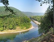
Haystacks
The Haystacks are mounds of sandstone that outcrop in Loyalsock Creek south of DushoreDushore, Pennsylvania
Dushore is a borough in Sullivan County, Pennsylvania, in the United States. The population was 608 at the 2010 census. Dushore is home to Sullivan County's only traffic light.-Geography:Dushore is located at ....
in Sullivan County
Sullivan County, Pennsylvania
Sullivan County is a county located in the U.S. state of Pennsylvania. As of 2010, the population is 6,428. Sullivan County was created on March 15, 1847, from part of Lycoming County and named for Charles Sullivan, leader of the Pennsylvania Senate...
. Geologically, they are a bed of quartz
Quartz
Quartz is the second-most-abundant mineral in the Earth's continental crust, after feldspar. It is made up of a continuous framework of SiO4 silicon–oxygen tetrahedra, with each oxygen being shared between two tetrahedra, giving an overall formula SiO2. There are many different varieties of quartz,...
sandstone
Sandstone
Sandstone is a sedimentary rock composed mainly of sand-sized minerals or rock grains.Most sandstone is composed of quartz and/or feldspar because these are the most common minerals in the Earth's crust. Like sand, sandstone may be any colour, but the most common colours are tan, brown, yellow,...
with an undulating upper surface, and are part of the Mississippian-Devonian
Devonian
The Devonian is a geologic period and system of the Paleozoic Era spanning from the end of the Silurian Period, about 416.0 ± 2.8 Mya , to the beginning of the Carboniferous Period, about 359.2 ± 2.5 Mya...
Upper Huntley Mountain Formation
Huntley Mountain Formation
The Huntley Mountain Formation is a late Devonian and early Mississippian mapped bedrock unit in Pennsylvania, in the United States.-Description:The formation is composed of relatively soft grayish-red shale and olive-gray sandstone...
.
Ostuagy
Madame Montour's village of Ostuagy was a vitally important location during the settlement of what is now Lycoming County. Her village at the mouth of Loyalsock Creek on the West Branch Susquehanna RiverWest Branch Susquehanna River
The West Branch Susquehanna River is one of the two principal branches, along with the North Branch, of the Susquehanna River in the northeastern United States. The North Branch, which rises in upstate New York, is generally regarded as the extension of the main branch, with the shorter West Branch...
was an important stopping point for the Moravian missionaries who were spreading the gospel throughout the wilderness of Pennsylvania
Province of Pennsylvania
The Province of Pennsylvania, also known as Pennsylvania Colony, was founded in British America by William Penn on March 4, 1681 as dictated in a royal charter granted by King Charles II...
during the 1740s. Count Zinzendorf, a missionary being guided by Conrad Weiser
Conrad Weiser
Weiser's colonial service began in 1731. The Iroquois sent Shikellamy, an Oneida chief, as an emissary to other tribes and the British. Shikellamy lived on the Susquehanna River at Shamokin village, near present-day Sunbury, Pennsylvania. An oral tradition holds that Weiser met Shikellamy while...
with the permission of Shikellamy
Shikellamy
Shikellamy , also known as Swatana, was an Oneida chief and overseer for the Iroquois confederacy. In his position as chief and overseer, Shikellamy served as a supervisor for the Six Nations, overseeing the Shawnee and Lenape tribes in central Pennsylvania along the Susquehanna River and...
, came to Ostuagy in 1742.
Madame Montour was known to be a friend of the British. She welcomed the white men who were beginning to migrate into the West Branch Susquehanna Valley
West Branch Susquehanna Valley
The West Branch Susquehanna Valley of central Pennsylvania, United States, in the Ridge-and-valley Appalachians, is the low lying area draining into the West Branch Susquehanna River southeast of the Allegheny Front, northeast of the Bald Eagle Valley, southwest of the Wyoming Valley and nort of...
. She also had a great amount of influence with the various Indian tribes that were feeling the pressure of colonial expansion. Madame Montour remained loyal to the British despite several attempts by the French to bring her over to their side. Historians note that this was remarkable due to the fact that the British colonial government sometimes went as long as a year without paying her for her services.
Rail transportation
Susquehanna and Eagles Mere Railroad
The Susquehanna and Eagles Mere Railroad was a logging railroad operating from 1902 to 1930 in Sullivan and Lycoming Counties in Pennsylvania in the United States....
, which built down into Hillsgrove and along the creek as far as Ogdonia in 1902, before turning up Kettle Creek. It was removed in 1922. Above Forksville, the Williamsport and North Branch Railroad
Williamsport and North Branch Railroad
The Williamsport and North Branch Railroad was a short line that operated in north-central Pennsylvania between 1872 and 1937. After a long struggle to finance its construction, it was completed in 1893. It derived most of its freight revenue from logging and to a certain extent from anthracite...
followed Mill Creek to reach the Loyalsock and followed it to a crossing at Ringdale. The line was built in 1893 and removed in 1938. About six miles (10 km) to the east, the town of Lopez is the largest settlement on the upper creek. Jennings Brothers Lumber Co. built a narrow-gauge logging line in the area in 1890, and another in 1891 up the creek into Wyoming County
Wyoming County, Pennsylvania
Wyoming County is a county located in the U.S. state of Pennsylvania. It was created in 1842 from part of Luzerne County. Its county seat is Tunkhannock.-Geography:According to the U.S...
, to supply their sawmill at Lopez. In 1892, the Loyalsock Railroad crossed the creek here, building south to bring coal from the Bernice area southward to Harvey's Lake. It was promptly leased to the Lehigh Valley Railroad
Lehigh Valley Railroad
The Lehigh Valley Railroad was one of a number of railroads built in the northeastern United States primarily to haul anthracite coal.It was authorized April 21, 1846 in the U.S. state of Pennsylvania and incorporated September 20, 1847 as the Delaware, Lehigh, Schuylkill and Susquehanna Railroad...
and became part of the Bowmans Creek Branch. At the same time, the Loyalsock Railroad also built a branch along the Loyalsock downstream from Lopez to Ellis Creek, where it turned south to reach a tannery at Thorndale. This branch was removed in 1898. However, Jennings Bros. continued to operate, standard-gauging their rail line about 1900 and building up the Loyalsock as far as Shumans Lake, where their line headed up Cold Run towards High Cobble and the Dutch Mountain area. The logging railroad was finally removed in 1905 when Jennings Bros. relocated to Maryland, but was partly resurrected in 1911. Stony Brook Lumber Co. used the old grade as far as Santee Run, then turned north towards Crane Swamp. This line was removed in 1916. Traffic gradually dwindled on the Lehigh Valley; their line south of Lopez was abandoned in 1939, and it was cut back to Bernice in 1944. This marked the end of rail traffic on the Loyalsock, except for the Reading Railroad crossing near its mouth at Montoursville. The bridge there is now owned by the Lycoming Valley Railroad
Lycoming Valley Railroad
The Lycoming Valley Railroad is a short line that operates of track in Lycoming and Clinton counties in Pennsylvania in the United States. It is part of the North Shore Railroad System....
, but was rendered unusable by flooding from Tropical Storm Lee
Tropical Storm Lee (2011)
Tropical Storm Lee was the twelfth named storm and thirteenth system overall of the 2011 Atlantic hurricane season, developing from a broad tropical disturbance over the Gulf on September 1. It was designated as Tropical Storm Lee the next day...
in 2011.
External links
- U.S. Geological Survey: PA stream gaging stations
- The Columbia Gazetteer of North America, 2000 entry for Loyalsock Creek
- Chesapeake Bay Watershed Page on the Loyalsock Creek watershed from the source to Little Loyalsock Creek
- Chesapeake Bay Watershed Page on the Loyalsock Creek watershed from Little Loyalsock Creek to the mouth
- Official Lycoming County Map showing all townships, villages, boroughs, cities, county roads, rivers, creeks, and some streams
- History of Lycoming County Pennsylvania edited by John F. Meginness, ©1892 (copyright expired)