

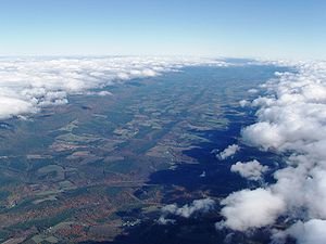
Bald Eagle Valley
Encyclopedia
Pennsylvania
The Commonwealth of Pennsylvania is a U.S. state that is located in the Northeastern and Mid-Atlantic regions of the United States. The state borders Delaware and Maryland to the south, West Virginia to the southwest, Ohio to the west, New York and Ontario, Canada, to the north, and New Jersey to...
, United States
United States
The United States of America is a federal constitutional republic comprising fifty states and a federal district...
is the low lying area draining into the Bald Eagle Creek
Bald Eagle Creek (West Branch Susquehanna River)
Bald Eagle Creek is a tributary of the West Branch Susquehanna River mostly in Centre County, Pennsylvania, in the United States. It runs through the Bald Eagle Valley at the foot of the Bald Eagle Mountain ridge to Lock Haven....
between the Allegheny Front
Allegheny Front
The Allegheny Front is the major southeast- or east-facing escarpment in the Allegheny Mountains in southern Pennsylvania, western Maryland, and eastern West Virginia, USA. The Allegheny Front delineates the Ridge-and-Valley Appalachians to its east from the Appalachian Plateau to its west...
and the Bald Eagle Mountain
Bald Eagle Mountain
Bald Eagle Mountain, once known locally as Muncy Mountain, is a stratigraphic ridge in central Pennsylvania, United States, running east of the Allegheny Front and northwest of Mount Nittany. It lies along the southeast side of Bald Eagle Creek, and south of the West Branch Susquehanna River, and...
ridge, south of the West Branch Susquehanna River
West Branch Susquehanna River
The West Branch Susquehanna River is one of the two principal branches, along with the North Branch, of the Susquehanna River in the northeastern United States. The North Branch, which rises in upstate New York, is generally regarded as the extension of the main branch, with the shorter West Branch...
, in the Ridge-and-valley Appalachians
Ridge-and-valley Appalachians
The Ridge-and-Valley Appalachians, also called the Ridge and Valley Province or the Valley and Ridge Appalachians, are a physiographic province of the larger Appalachian division and are also a belt within the Appalachian Mountains extending from southeastern New York through northwestern New...
. It is southwest of the West Branch Susquehanna Valley
West Branch Susquehanna Valley
The West Branch Susquehanna Valley of central Pennsylvania, United States, in the Ridge-and-valley Appalachians, is the low lying area draining into the West Branch Susquehanna River southeast of the Allegheny Front, northeast of the Bald Eagle Valley, southwest of the Wyoming Valley and nort of...
that includes Williamsport
Williamsport, Pennsylvania
Williamsport is a city in and the county seat of Lycoming County, Pennsylvania in the United States. In 2009, the population was estimated at 29,304...
and Northwest of the Nittany Valley
Nittany Valley
The Nittany Valley is an eroded anticlinal valley in the central portion of Centre County, Pennsylvania in the United States. It is separated from the Bald Eagle Valley by Bald Eagle Mountain and from Penns Valley by Mount Nittany. The valley is closed to the north by a high plateau that joins...
that includes State College
State College, Pennsylvania
State College is the largest borough in Centre County in the U.S. state of Pennsylvania. It is the principal city of the State College, Pennsylvania Metropolitan Statistical Area which encompasses all of Centre County. As of the 2010 census, the borough population was 42,034, and roughly double...
.
The Bald Eagle Valley lies in the central portion of Centre County
Centre County, Pennsylvania
Centre County is a county located in the U.S. state of Pennsylvania. It is part of the State College, Pennsylvania Metropolitan Statistical Area. As of 2010, the population was 153,990....
and the southern portion of Clinton County
Clinton County, Pennsylvania
As of the census of 2000, there were 37,914 people, 14,773 households, and 9,927 families residing in the county. The population density was 43 people per square mile . There were 18,166 housing units at an average density of 20 per square mile...
. It runs from Port Matilda
Port Matilda, Pennsylvania
Port Matilda is a borough in Centre County, Pennsylvania, United States. It is part of the State College, Pennsylvania Metropolitan Statistical Area...
down to Lock Haven
Lock Haven, Pennsylvania
The city of Lock Haven is the county seat of Clinton County, in the U.S. state of Pennsylvania. Located near the confluence of the West Branch Susquehanna River and Bald Eagle Creek, it is the principal city of the Lock Haven, Pennsylvania, micropolitan statistical area, itself part of the...
PA, It includes most of the Bald Eagle Area School District and Bald Eagle Township
Bald Eagle Township, Pennsylvania
Bald Eagle Township is a township in Clinton County, Pennsylvania, United States. The population was 1,898 at the 2000 census.-Geography:According to the United States Census Bureau, the township has a total area of , of which, of it is land and of it is water.-Demographics:As of the census of...
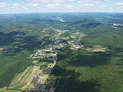
. The Bald Eagle State Park
Bald Eagle State Park
Bald Eagle State Park is a Pennsylvania state park in Howard, Liberty, and Marion townships in Centre County, Pennsylvania in the United States. The park includes the Joseph Foster Sayers Reservoir, formed by damming Bald Eagle Creek and other smaller streams and covering . Bald Eagle State Park...
is also in the valley. The park includes the Joseph Foster Sayers Reservoir, around the town of Howard
Howard, Pennsylvania
Howard is a borough in Centre County, Pennsylvania, United States. It is part of the State College, Pennsylvania Metropolitan Statistical Area. The population was 720 at the 2010 census.-Geography:Howard is located at ....
, a prominent topographic feature formed by damming Bald Eagle Creek.
Principal towns in the Bald Eagle Valley
- Port MatildaPort Matilda, PennsylvaniaPort Matilda is a borough in Centre County, Pennsylvania, United States. It is part of the State College, Pennsylvania Metropolitan Statistical Area...
- JulianJulian, PennsylvaniaJulian, is a census-designated place in Centre County, Pennsylvania, United States. It is part of the State College, Pennsylvania Metropolitan Statistical Area. The population was 152 at the 2000 census...
- UnionvilleUnionville, Centre County, PennsylvaniaUnionville is a borough in Centre County, Pennsylvania, United States. It is part of the State College, Pennsylvania Metropolitan Statistical Area...
- MilesburgMilesburg, PennsylvaniaMilesburg is a borough in Centre County, Pennsylvania, United States. It is part of the State College, Pennsylvania Metropolitan Statistical Area. The population was 1,187 at the 2000 census...
- HowardHoward, PennsylvaniaHoward is a borough in Centre County, Pennsylvania, United States. It is part of the State College, Pennsylvania Metropolitan Statistical Area. The population was 720 at the 2010 census.-Geography:Howard is located at ....
- Beech CreekBeech Creek, PennsylvaniaBeech Creek is a borough in Clinton County, Pennsylvania, United States. The population was 717 at the 2000 census. It is the setting for Fun Home, a 2006 graphic memoir by Alison Bechdel, who grew up there...
- Mill Hall
- Lock HavenLock Haven, PennsylvaniaThe city of Lock Haven is the county seat of Clinton County, in the U.S. state of Pennsylvania. Located near the confluence of the West Branch Susquehanna River and Bald Eagle Creek, it is the principal city of the Lock Haven, Pennsylvania, micropolitan statistical area, itself part of the...
Agriculture
In the upper valley, the Bald Eagle Creek runs at the foot of the ridge in a narrow floodplainFloodplain
A floodplain, or flood plain, is a flat or nearly flat land adjacent a stream or river that stretches from the banks of its channel to the base of the enclosing valley walls and experiences flooding during periods of high discharge...
. Long narrow farm fields lie along the river, and along the perpendicular side vallies
Side valley
The terms side valley and tributary valley refer to valleys whose brook or river is confluent to a greater one.Upstream, the valleys can be classified in an increasing order which is equivalent to the usual orographic order: the tributaries are ordered from those nearest to the source of the river...
of the creek's tributaries. Smaller irregular sloped fields also lie on the small hills near the floodplain. Further down stream, the flood plain becomes wider, and larger farm fields are found there. Between the flood plain and the plateau, there are two distinct regions. Nearer the flood plain, there are steeper wooded hills, generally not suitable for farming. Closer to the plateau, there are more gently rolling hills, with fields and pastures mixed with woodlots. Corn, hay, alfalfa, and winter wheat are crops commonly grown in the valley.
Transportation
Road
U.S. Alternate Route 220, the main route along the valley, ran along the flood plain, but the main route designation has been relocated to the Nittany Valley north of Port Matilda in conjunction with the ongoing extension of US Interstate 99Interstate 99
Interstate 99 is an intrastate Interstate Highway located in central Pennsylvania in the United States. The southern terminus of the route is at exit 146 of the Pennsylvania Turnpike north of Bedford, where the road continues south as U.S. Route 220 . The northern terminus is at...
to Interstate 80
Interstate 80
Interstate 80 is the second-longest Interstate Highway in the United States, following Interstate 90. It is a transcontinental artery running from downtown San Francisco, California to Teaneck, New Jersey in the New York City Metropolitan Area...
. The road north of there is now known as U.S. 220 Alternate. I-80 runs east-west across the valley between Snow Shoe, Pennsylvania
Snow Shoe, Pennsylvania
Snow Shoe is a borough in Centre County, Pennsylvania, United States. It is part of the State College, Pennsylvania Metropolitan Statistical Area...
and Bellefonte, Pennsylvania
Bellefonte, Pennsylvania
Bellefonte is a borough in Centre County, Pennsylvania, United States. It lies about twelve miles northeast of State College and is part of the State College, Pennsylvania Metropolitan Statistical Area...
. U.S. Route 322
U.S. Route 322
U.S. Route 322 is a long, east–west United States Highway, traversing Ohio, Pennsylvania, and New Jersey. The road is a spur of U.S. Route 22 and one of the original highways from 1926...
, Skytop Mountain Road, also crosses the valley through Port Matilda, and across the ridge in a cut at "Skytop". I-99, now scheduled to open in 2008 after construction delays, runs through the upper valley mostly along the ridge, then wraps around Port Matilda to pick up U.S. 322 in a tandem alignment, before crossing the ridge in the now expanded Skytop cut.
Canal
The Bald Eagle and Spring Creek NavigationBald Eagle and Spring Creek Navigation
The Bald Eagle and Spring Creek Navigation Company was a canal company in central Pennsylvania intended to link the iron industry of Bellefonte, Pennsylvania, with the Pennsylvania canal system. Opened for half its length in 1837, the remainder of the canal was not completed until 1848...
began building up the Bald Eagle Valley from Lock Haven in 1834. It reached Howard in 1837, but construction stalled, and it only reached Milesburg in 1847, and Bellefonte in 1848. Initially successful, the canal began to face railroad competition during the American Civil War
American Civil War
The American Civil War was a civil war fought in the United States of America. In response to the election of Abraham Lincoln as President of the United States, 11 southern slave states declared their secession from the United States and formed the Confederate States of America ; the other 25...
, and was not rebuilt after its destruction by flooding in 1865.
Rail
Construction began in 1858 on Centre County's first railroad, the Bellefonte and Snow Shoe Railroad, which entered the valley through the Spring Creek water gapWater gap
A water gap is an opening or notch which flowing water has carved through a mountain range. Water gaps often offer a practical route for road and rail transport to cross mountain ridges.- Geology :...
at Milesburg. By 1862 the line up the Wallace Run side valley, from Wingate to the timber and coal resources of Snow Shoe
Snow Shoe, Pennsylvania
Snow Shoe is a borough in Centre County, Pennsylvania, United States. It is part of the State College, Pennsylvania Metropolitan Statistical Area...
, was completed. It ran along the stream bed to the foot of the Allegheny Front
Allegheny Front
The Allegheny Front is the major southeast- or east-facing escarpment in the Allegheny Mountains in southern Pennsylvania, western Maryland, and eastern West Virginia, USA. The Allegheny Front delineates the Ridge-and-Valley Appalachians to its east from the Appalachian Plateau to its west...
, then climbed half of the line's 886 feet (270.1 m) vertical rise via a unique series of switchbacks
Zig Zag (railway)
A railway zig zag, also called a switchback, is a way of climbing hills in difficult country with a minimal need for tunnels and heavy earthworks. For a short distance , the direction of travel is reversed, before the original direction is resumed.A location on railways constructed e.g...
in a steep box canyon near 40.99°N 77.88°W http://www.topozone.com/map.asp?lat=40.99&lon=-77.88&size=m&s=48.
The Pennsylvania Railroad
Pennsylvania Railroad
The Pennsylvania Railroad was an American Class I railroad, founded in 1846. Commonly referred to as the "Pennsy", the PRR was headquartered in Philadelphia, Pennsylvania....
financed the construction of the Bald Eagle Valley Railroad
Bald Eagle Valley Railroad
The Bald Eagle Valley Railroad was a subsidiary of the Pennsylvania Railroad which owned several rail lines in central Pennsylvania. It had its genesis in the Tyrone and Lock Haven Railroad, a financially-troubled railroad chartered in 1857, which was unable to complete more than a small portion of...
line through the valley, along the flood plain from Tyrone to Lock Haven. When completed in 1865, it used the Bellefonte & Snow Shoe Railroad track between Wingate and Milesburg. The Pennsylvania Railroad bought the Bellefonte & Snow Shoe Railroad in 1881, making its former line the Snow Shoe and Bellefonte branches. The Snow Shoe branch has been abandoned, but the Nittany and Bald Eagle Railroad
Nittany and Bald Eagle Railroad
The Nittany and Bald Eagle Railroad is a short line railroad that operates of track in Blair, Centre, and Clinton counties in Pennsylvania in the United States. It is part of the North Shore Railroad System....
short line still runs the lines from Tyrone to Lock Haven and Bellefonte.
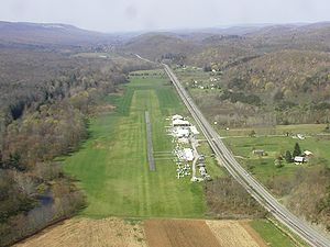
Air
Ridge Soaring GliderportRidge Soaring Gliderport
Ridge Soaring Gliderport is a public-use glider airport located two nautical miles southwest of the central business district of Unionville, in Centre County, Pennsylvania, United States. It is privately owned by Knauff & Grove, Inc....
, the only airport in the valley, is active (except in winter) with pilot training and glider
Glider (sailplane)
A glider or sailplane is a type of glider aircraft used in the sport of gliding. Some gliders, known as motor gliders are used for gliding and soaring as well, but have engines which can, in some cases, be used for take-off or for extending a flight...
rides. The former Peterson Memorial Airport, near Tyrone, closed in 1976, and was converted to an industrial park.http://www.airfields-freeman.com/PA/Airfields_PA_NC.htm
Geology
Bald Eagle Valley is in the western part of the Ridge and Valley province of the Appalachian MountainsAppalachian Mountains
The Appalachian Mountains #Whether the stressed vowel is or ,#Whether the "ch" is pronounced as a fricative or an affricate , and#Whether the final vowel is the monophthong or the diphthong .), often called the Appalachians, are a system of mountains in eastern North America. The Appalachians...
. During the Appalachian orogeny, sedimentary rock
Sedimentary rock
Sedimentary rock are types of rock that are formed by the deposition of material at the Earth's surface and within bodies of water. Sedimentation is the collective name for processes that cause mineral and/or organic particles to settle and accumulate or minerals to precipitate from a solution....
layers on the supercontinent of Pangaea
Pangaea
Pangaea, Pangæa, or Pangea is hypothesized as a supercontinent that existed during the Paleozoic and Mesozoic eras about 250 million years ago, before the component continents were separated into their current configuration....
were folded
Fold (geology)
The term fold is used in geology when one or a stack of originally flat and planar surfaces, such as sedimentary strata, are bent or curved as a result of permanent deformation. Synsedimentary folds are those due to slumping of sedimentary material before it is lithified. Folds in rocks vary in...
, forming a huge mountain range. The Nittany Arch
Nittany Arch
The Nittany Arch or Nittany anticline is an anticline geologic formation in the western part of the Ridge-and-Valley physiographic province of the Appalachian Mountains of Central Pennsylvania, United States...
was an ancient Himalayan scale mountain that once towered above what is now the adjacent Nittany Valley
Nittany Valley
The Nittany Valley is an eroded anticlinal valley in the central portion of Centre County, Pennsylvania in the United States. It is separated from the Bald Eagle Valley by Bald Eagle Mountain and from Penns Valley by Mount Nittany. The valley is closed to the north by a high plateau that joins...
.
The oldest rock layers from deep within the eroded
Erosion
Erosion is when materials are removed from the surface and changed into something else. It only works by hydraulic actions and transport of solids in the natural environment, and leads to the deposition of these materials elsewhere...
mountain are now exposed on the east side of the Bald Eagle ridge. Younger rocks from the outer layers of the arch are exposed in the Bald Eagle Valley, with the youngest at the foot of the Allegheny Front
Allegheny Front
The Allegheny Front is the major southeast- or east-facing escarpment in the Allegheny Mountains in southern Pennsylvania, western Maryland, and eastern West Virginia, USA. The Allegheny Front delineates the Ridge-and-Valley Appalachians to its east from the Appalachian Plateau to its west...
. The rock layers in the valley were folded from horizontal to almost vertical, and now read like pages in a geologic history book covering the entire Devonian
Devonian
The Devonian is a geologic period and system of the Paleozoic Era spanning from the end of the Silurian Period, about 416.0 ± 2.8 Mya , to the beginning of the Carboniferous Period, about 359.2 ± 2.5 Mya...
period. The vertical attitude of the rocks also contributes to the straightness of the valley. http://www.libraries.psu.edu/emsl/guides/X/centre.htm
Erosion resistant Silurian
Silurian
The Silurian is a geologic period and system that extends from the end of the Ordovician Period, about 443.7 ± 1.5 Mya , to the beginning of the Devonian Period, about 416.0 ± 2.8 Mya . As with other geologic periods, the rock beds that define the period's start and end are well identified, but the...
Tuscarora Formation
Tuscarora Formation
The Silurian Tuscarora Formation — also known as Tuscarora Sandstone or Tuscarora Quartzite — is a mapped bedrock unit in Pennsylvania, Maryland, West Virginia, and Virginia.-Description:...
Quartzite
Quartzite
Quartzite is a hard metamorphic rock which was originally sandstone. Sandstone is converted into quartzite through heating and pressure usually related to tectonic compression within orogenic belts. Pure quartzite is usually white to gray, though quartzites often occur in various shades of pink...
left the Bald Eagle ridge standing above the valley. The Bald Eagle Creek runs at the foot of the ridge on a bed of Devonian
Devonian
The Devonian is a geologic period and system of the Paleozoic Era spanning from the end of the Silurian Period, about 416.0 ± 2.8 Mya , to the beginning of the Carboniferous Period, about 359.2 ± 2.5 Mya...
Hamilton Group
Hamilton Group
The Devonian Hamilton Group is a mapped bedrock unit in New York, Pennsylvania, Maryland, and West Virginia. In Virginia, it is known as the laterally equivalent Millboro Shale.The group is named for the village of Hamilton, New York...
Shale
Shale
Shale is a fine-grained, clastic sedimentary rock composed of mud that is a mix of flakes of clay minerals and tiny fragments of other minerals, especially quartz and calcite. The ratio of clay to other minerals is variable. Shale is characterized by breaks along thin laminae or parallel layering...
. Durable Lock Haven Formation
Lock Haven Formation
The Lock Haven Formation is a Devonian mapped bedrock unit in Pennsylvania, in the Appalachian Mountains of the United States.-Description:The Lock Haven is gray to green-brown sandstone, siltstone, and shale and is over 400 million years old...
Mudstone
Mudstone
Mudstone is a fine grained sedimentary rock whose original constituents were clays or muds. Grain size is up to 0.0625 mm with individual grains too small to be distinguished without a microscope. With increased pressure over time the platey clay minerals may become aligned, with the...
forms a parallel series of steep elongated knolls running west of the flood plain, some almost as high as the ridge. Catskill Formation Sandstone
Sandstone
Sandstone is a sedimentary rock composed mainly of sand-sized minerals or rock grains.Most sandstone is composed of quartz and/or feldspar because these are the most common minerals in the Earth's crust. Like sand, sandstone may be any colour, but the most common colours are tan, brown, yellow,...
underlies a series of lower gently rolling hills at the foot of the plateau, which is in turn formed from uplifted
Tectonic uplift
Tectonic uplift is a geological process most often caused by plate tectonics which increases elevation. The opposite of uplift is subsidence, which results in a decrease in elevation. Uplift may be orogenic or isostatic.-Orogenic uplift:...
Mississippian Sandstone.
See also: Geology of Bald Eagle Mountain