

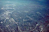
Urban sprawl
Encyclopedia
Suburb
The word suburb mostly refers to a residential area, either existing as part of a city or as a separate residential community within commuting distance of a city . Some suburbs have a degree of administrative autonomy, and most have lower population density than inner city neighborhoods...
s to its outskirts to low-density and auto-dependent development on rural land, high segregation of uses (e.g. stores and residential), and various design features that encourage car dependency.
Discussions and debates about sprawl are often obfuscated by the ambiguity associated with the phrase. For example, some commentators measure sprawl only with the average number of residential units per acre in a given area. But others associate it with decentralization (spread of population without a well-defined centre), discontinuity (leapfrog development, as defined below), segregation of uses, and so forth.
The term urban sprawl generally has negative connotations due to the health, environmental and cultural issues associated with the phrase. Residents of sprawling neighbourhoods tend to emit more pollution per person and suffer more traffic fatalities. Sprawl is controversial, with supporters claiming that consumers prefer lower density neighbourhoods and that sprawl does not necessarily increase traffic.
Characteristics

Land use
Land use is the human use of land. Land use involves the management and modification of natural environment or wilderness into built environment such as fields, pastures, and settlements. It has also been defined as "the arrangements, activities and inputs people undertake in a certain land cover...
patterns that usually occur in unison:
Single-use zoning
This refers to a situation where commercial, residentialResidential area
A residential area is a land use in which housing predominates, as opposed to industrial and commercial areas.Housing may vary significantly between, and through, residential areas. These include single family housing, multi-family residential, or mobile homes. Zoning for residential use may permit...
, institutional and industrial areas are separated from one another. Consequently, large tracts of land are devoted to a single use and are segregated from one another by open space, infrastructure, or other barriers. As a result, the places where people live, work, shop, and recreate are far from one another, usually to the extent that walking, transit use and bicycling are impractical, so all these activities generally require an automobile
Automobile
An automobile, autocar, motor car or car is a wheeled motor vehicle used for transporting passengers, which also carries its own engine or motor...
.
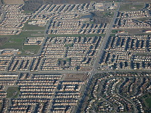
Low-density zoning
Sprawl consumes much more land per-capita than traditional urban developments because zoning laws generally require that new developments are of low density. The exact definition of "low density" is arguable, but a common example is that of single family homesSingle-family home
A single-family detached home, also called a single-detached dwelling or separate house is a free-standing residential building. It is defined in opposition to a multi-family dwelling.- Definitions :...
on large lots, with four or fewer units per net acre. Buildings usually have fewer stories and are spaced farther apart, separated by lawn
Lawn
A lawn is an area of aesthetic and recreational land planted with grasses or other durable plants, which usually are maintained at a low and consistent height. Low ornamental meadows in natural landscaping styles are a contemporary option of a lawn...
s, landscaping
Landscaping
Landscaping refers to any activity that modifies the visible features of an area of land, including:# living elements, such as flora or fauna; or what is commonly referred to as gardening, the art and craft of growing plants with a goal of creating a beautiful environment within the landscape.#...
, road
Road
A road is a thoroughfare, route, or way on land between two places, which typically has been paved or otherwise improved to allow travel by some conveyance, including a horse, cart, or motor vehicle. Roads consist of one, or sometimes two, roadways each with one or more lanes and also any...
s or parking lot
Parking lot
A parking lot , also known as car lot, is a cleared area that is intended for parking vehicles. Usually, the term refers to a dedicated area that has been provided with a durable or semi-durable surface....
s. Lot sizes are larger, and because more automobiles are used much more land is designated for parking. The impact of low density development in many communities is that developed or "urbanized" land is increasing at a faster rate than the rate of population.
Overall density is often lowered by "leap-frog development". This term refers to the relationship, or lack thereof, between subdivisions. Such developments are typically separated by large green belt
Green belt
A green belt or greenbelt is a policy and land use designation used in land use planning to retain areas of largely undeveloped, wild, or agricultural land surrounding or neighbouring urban areas. Similar concepts are greenways or green wedges which have a linear character and may run through an...
s, i.e. tracts of undeveloped land, resulting in an average density far lower even than the low density described in the previous paragraph. This is a 20th and 21st century phenomenon generated by the current custom of requiring a developer to provide subdivision infrastructure as a condition of development (DeGrove and Turner, 1991). Usually, the developer is required to set aside a certain percentage of the developed land for public use, including roads, parks and schools. In the past, when a local government
Local government
Local government refers collectively to administrative authorities over areas that are smaller than a state.The term is used to contrast with offices at nation-state level, which are referred to as the central government, national government, or federal government...
built all the streets in a given location, the town could expand without interruption and with a coherent circulation system, because it had condemnation power.
Eminent domain
Eminent domain , compulsory purchase , resumption/compulsory acquisition , or expropriation is an action of the state to seize a citizen's private property, expropriate property, or seize a citizen's rights in property with due monetary compensation, but without the owner's consent...
Private developers generally do not have such power (although they can sometimes find local governments willing to help), and often choose to develop on the tracts that happen to be for sale at the time they want to build, rather than pay extra or wait for a more appropriate location.
Car-dependent communities
Areas of urban sprawl are also characterized as highly dependent on automobileAutomobile
An automobile, autocar, motor car or car is a wheeled motor vehicle used for transporting passengers, which also carries its own engine or motor...
s for transportation, a condition known as automobile dependency
Automobile dependency
Automobile dependency is a term coined by Professors Peter Newman and Jeff Kenworthy to capture the predicament of most cities in the United States, Canada, Australia and New Zealand, and to a lesser extent, large cities in Europe....
. Most activities, such as shopping and commuting
Commuting
Commuting is regular travel between one's place of residence and place of work or full time study. It sometimes refers to any regular or often repeated traveling between locations when not work related.- History :...
to work, require the use of a car as a result of both the area's isolation from the city and the isolation the area's residential zones have from its industrial and commercial zones. Walking
Walking
Walking is one of the main gaits of locomotion among legged animals, and is typically slower than running and other gaits. Walking is defined by an 'inverted pendulum' gait in which the body vaults over the stiff limb or limbs with each step...
and other methods of transit are not practical; therefore, many of these areas have few or no sidewalks. In many suburban communities, stores and activities that are in close proximity "as the crow flies" require automobiles, because the different areas are separated by fences, walls, and drainage ditches. Some critics argue that excessive parking requirements exacerbate car dependency.
Job Sprawl and Spatial Mismatch
Job Sprawl is another land use symptom of urban sprawl and car-dependent communities. It is defined as low-density, geographically spread-out patterns of employment, where the majority of jobs in a given metropolitan area are located outside of the main city's Central Business DistrictCentral business district
A central business district is the commercial and often geographic heart of a city. In North America this part of a city is commonly referred to as "downtown" or "city center"...
(CBD), and increasingly in the suburban periphery. It is often the result of urban disinvestment, the geographic freedom of employment location allowed by predominantly car-dependent commuting patterns of many American suburbs, and many companies' desire to locate in low-density areas that are often more affordable and offer potential for expansion. Spatial mismatch
Spatial mismatch
Spatial mismatch is the sociological, economic and political phenomenon associated with economic restructuring in which employment opportunities for low-income people are located far away from the areas where they live...
is related to job sprawl and economic Environmental Justice
Environmental justice
Environmental justice is "the fair treatment and meaningful involvement of all people regardless of race, color, sex, national origin, or income with respect to the development, implementation and enforcement of environmental laws, regulations, and policies." In the words of Bunyan Bryant,...
. Spatial Mismatch is defined as the situation where poor urban, predominantly minority citizens are left without easy access to entry-level jobs, as a result of increasing job sprawl and limited transportation options to facilitate a reverse commute to the suburbs.
Job sprawl has been documented and measured in various ways. It has been shown to be a growing trend in America's metropolitan areas.{cn} The Brookings Institution
Brookings Institution
The Brookings Institution is a nonprofit public policy organization based in Washington, D.C., in the United States. One of Washington's oldest think tanks, Brookings conducts research and education in the social sciences, primarily in economics, metropolitan policy, governance, foreign policy, and...
has published multiple articles on the topic. In 2005, author Michael Stoll defined job sprawl simply as jobs located more than 5 miles (8 km) radius from the CBD, and measured the concept based on year 2000 U.S. Census data. Other ways of measuring the concept with more detailed rings around the CBD include a 2001 article by Edward Glaeser and Elizabeth Kneebone's 2009 article, which show that sprawling urban peripheries are gaining employment while areas closer to the CBD are losing jobs. These two authors used three geographic rings limited to a 35 miles (56.3 km) radius around the CBD: 3 miles (4.8 km) or less, 3 to 10 miles (16.1 km), and 10 to 35 miles (56.3 km). Kneebone's study showed the following nationwide breakdown for the largest metropolitan areas in 2006: 21.3% of jobs located in the inner ring, 33.6% of jobs in the 3-10 mile ring, and 45.1% in the 10-35 mile ring. This compares to the year 1998 - 23.3%, 34.2%, and 42.5% in those respective rings. The study shows CBD employment share shrinking, and job growth focused in the suburban and exurban outer metropolitan rings.
In terms of measurement, spatial mismatch can be thought of as the percentage of people who would have to move in order to be distributed in the same way as jobs. Stoll's research shows that a substantially higher percentage of African Americans (53.5%) experience spatial mismatch than European Americans (35.6%). On average, more than half of African American citizens would need to move to accomplish similar distribution to jobs. Latinos (45.8%) experience spatial mismatch as well, though to a lesser extent than African Americans.
Housing subdivisions
New urbanism
New Urbanism is an urban design movement, which promotes walkable neighborhoods that contain a range of housing and job types. It arose in the United States in the early 1980s, and has gradually continued to reform many aspects of real estate development, urban planning, and municipal land-use...
architectural firm Duany Plater-Zyberk & Company claim that housing subdivisions “are sometimes called villages, towns, and neighbourhoods by their developers, which is misleading since those terms denote places that are not exclusively residential.” They are also referred to as developments.
Subdivisions often incorporate curved roads and cul-de-sac
Cul-de-sac
A cul-de-sac is a word of French origin referring to a dead end, close, no through road or court meaning dead-end street with only one inlet/outlet...
s. Such subdivisions may offer only a few places to enter and exit the development, causing traffic to use high volume collector streets. All trips, no matter how short, must enter the collector road in a suburban system. (Duany Plater-Zyberk 5, 34)
Strip malls
Shopping centres are locations consisting of retail space. In the U.S. and Canada, these vary from strip malls, which refer to collections of buildings sharing a common parking lot, usually built on a high-capacity roadway with commercial functions (i.e., a "strip"). Similar developments in the UK are called Retail Parks. Strip malls/retail parks contain a wide variety of retail and non-retail functions that also cater to daily use (e.g. video rental, takeout food, laundry services, hairdresser). Strip malls consisting mostly of big box stores or category killerCategory killer
Category killer is a term used in marketing and strategic management to describe a product, service, brand, or company that has such a distinct sustainable competitive advantage that competing firms find it almost impossible to operate profitably in that industry...
s are sometimes called "power centers" (U.S.). These developments tend to be low-density; the buildings are single-storey and there is ample space for parking and access for delivery vehicles. This character is reflected in the spacious landscaping of the parking lots and walkways and clear signage of the retail establishments. Some strip malls are undergoing a transformation into Lifestyle centres; entailing investments in common areas and facilities (plazas, cafes) and shifting tenancy from daily goods to recreational shopping. European countries such as France, Belgium and Germany have implemented size restrictions for superstores found in strip malls in an effort to limit sprawl (Davies 1995).
Shopping malls
Another prominent form of retail development in areas characterized by "sprawl" is the shopping mallShopping mall
A shopping mall, shopping centre, shopping arcade, shopping precinct or simply mall is one or more buildings forming a complex of shops representing merchandisers, with interconnecting walkways enabling visitors to easily walk from unit to unit, along with a parking area — a modern, indoor version...
. Unlike the strip mall, this is usually composed of a single building surrounded by a parking lot that contains multiple shops, usually "anchored" by one or more department store
Department store
A department store is a retail establishment which satisfies a wide range of the consumer's personal and residential durable goods product needs; and at the same time offering the consumer a choice of multiple merchandise lines, at variable price points, in all product categories...
s (Gruen and Smith 1960). The function and size is also distinct from the strip mall. The focus is almost exclusively on recreational shopping rather than daily goods. Shopping malls also tend to serve a wider (regional) public and require higher-order infrastructure such as highway access and can have floorspaces in excess of a million square feet (ca. 100,000 m²). Shopping malls are often detrimental to downtown shopping centres of nearby cities since the shopping malls act as a surrogate for the city centre
Central business district
A central business district is the commercial and often geographic heart of a city. In North America this part of a city is commonly referred to as "downtown" or "city center"...
(Crawford 1992). Some downtowns have responded to this challenge by building shopping centres of their own (Frieden and Sagelyn 1989; consider also Toronto Eaton Centre
Toronto Eaton Centre
The Toronto Eaton Centre is a large shopping mall and office complex in downtown Toronto, Ontario, Canada, named after the now-defunct Eaton's department store chain that once anchored it. In terms of the number of visitors, the shopping mall is Toronto's top tourist attraction, with around one...
(1977), Ottawa
Ottawa
Ottawa is the capital of Canada, the second largest city in the Province of Ontario, and the fourth largest city in the country. The city is located on the south bank of the Ottawa River in the eastern portion of Southern Ontario...
's Rideau Centre
Rideau Centre
Rideau Centre is a three-level shopping centre on Rideau Street in Downtown Ottawa, Ontario, Canada. It borders on Rideau Street , the Rideau Canal, the Mackenzie King Bridge, and Nicholas Street....
, Boston's Shops at Prudential Center
Shops at Prudential Center
The Shops at Prudential Center is an urban shopping center located at the base of the Prudential Tower in Boston, Massachusetts. The mall lies adjacent to many other destinations such as: Hynes Convention Center, the 101/111 Huntington Avenue office towers, and a skywalk connecting it to Copley...
, and Providence's Providence Place
Providence Place
Providence Place is an urban shopping mall in the central part of Providence, Rhode Island. Opened on August 20, 1999, it is located near the Rhode Island State House and Providence Station. It compromises three main floors and is connected to the nearby Westin Hotel via skyway. It also features...
).
In the 1970s, the Ontario government created the Ontario Downtown Renewal Programme, which helped finance the building of several downtown malls across Ontario (such as the aforementioned Eaton Centre). The program was created to reverse the tide of small business leaving downtowns for larger sites surrounding the city.
Fast food chains
Fast foodFast food
Fast food is the term given to food that can be prepared and served very quickly. While any meal with low preparation time can be considered to be fast food, typically the term refers to food sold in a restaurant or store with preheated or precooked ingredients, and served to the customer in a...
chains are common in suburban areas. They are often built early in areas with low property values where the population is expected to boom and where large traffic is predicted, and set a precedent for future development. Eric Schlosser
Eric Schlosser
Eric Schlosser is an American journalist and author known for investigative journalism, such as in his books Fast Food Nation, Reefer Madness and Chew On This.- Personal History :...
, in his book Fast Food Nation
Fast Food Nation
Fast Food Nation: The Dark Side of the All-American Meal is a book by investigative journalist Eric Schlosser that examines the local and global influence of the United States fast food industry....
, argues that fast food chains accelerate suburban sprawl and help set its tone with their expansive parking lots, flashy signs, and plastic architecture (65). Duany Plater Zyberk & Company
Duany Plater Zyberk & Company
Duany Plater-Zyberk & Company is a Miami, Florida-based architecture and town planning firm founded in 1980 by the husband-and-wife team of Andrés Duany and Elizabeth Plater-Zyberk. It is one of the dominant firms specializing in new urbanist town planning in the United States and other countries,...
believe that this reinforces a destructive pattern of growth in an endless quest to move away from the sprawl that only results in creating more of it (Duany Plater-Zyberk 26).
Examples
According to the National Resources Inventory (NRI), about 8,900 square kilometres (2.2 million acres) of land in the United States was developed between 1992 and 2002. Presently, the NRI classifies approximately 100,000 more square kilometres (40,000 square miles) (an area approximately the size of KentuckyKentucky
The Commonwealth of Kentucky is a state located in the East Central United States of America. As classified by the United States Census Bureau, Kentucky is a Southern state, more specifically in the East South Central region. Kentucky is one of four U.S. states constituted as a commonwealth...
) as developed than the Census Bureau
United States Census Bureau
The United States Census Bureau is the government agency that is responsible for the United States Census. It also gathers other national demographic and economic data...
classifies as urban. The difference in the NRI classification is that it includes rural development, which by definition cannot be considered to be "urban" sprawl. Currently, according to the 2000 Census
United States Census, 2000
The Twenty-second United States Census, known as Census 2000 and conducted by the Census Bureau, determined the resident population of the United States on April 1, 2000, to be 281,421,906, an increase of 13.2% over the 248,709,873 persons enumerated during the 1990 Census...
, approximately 2.6 percent of the U.S. land area is urban. Approximately 0.8 percent of the nation's land is in the 37 urbanized areas with more than 1,000,000 population. In 2002, these 37 urbanized areas supported around 40% of the total American population.
Urban area
An urban area is characterized by higher population density and vast human features in comparison to areas surrounding it. Urban areas may be cities, towns or conurbations, but the term is not commonly extended to rural settlements such as villages and hamlets.Urban areas are created and further...
s have expanded geographically even while losing population. But it was not just urbanized areas in the U.S. that lost population and sprawled substantially. According to data in "Cities and Automobile Dependence" by Kenworthy and Laube (1999), urbanized area population losses occurred while there was an expansion of sprawl between 1970 and 1990 in Brussels, Belgium; Copenhagen, Denmark; Frankfurt
Frankfurt
Frankfurt am Main , commonly known simply as Frankfurt, is the largest city in the German state of Hesse and the fifth-largest city in Germany, with a 2010 population of 688,249. The urban area had an estimated population of 2,300,000 in 2010...
, Hamburg
Hamburg
-History:The first historic name for the city was, according to Claudius Ptolemy's reports, Treva.But the city takes its modern name, Hamburg, from the first permanent building on the site, a castle whose construction was ordered by the Emperor Charlemagne in AD 808...
, and Munich
Munich
Munich The city's motto is "" . Before 2006, it was "Weltstadt mit Herz" . Its native name, , is derived from the Old High German Munichen, meaning "by the monks' place". The city's name derives from the monks of the Benedictine order who founded the city; hence the monk depicted on the city's coat...
, Germany
Germany
Germany , officially the Federal Republic of Germany , is a federal parliamentary republic in Europe. The country consists of 16 states while the capital and largest city is Berlin. Germany covers an area of 357,021 km2 and has a largely temperate seasonal climate...
; and Zurich
Zürich
Zurich is the largest city in Switzerland and the capital of the canton of Zurich. It is located in central Switzerland at the northwestern tip of Lake Zurich...
, Switzerland
Switzerland
Switzerland name of one of the Swiss cantons. ; ; ; or ), in its full name the Swiss Confederation , is a federal republic consisting of 26 cantons, with Bern as the seat of the federal authorities. The country is situated in Western Europe,Or Central Europe depending on the definition....
, albeit without the wholesale dismantling of public transit systems that occurred in the United States.
United States
The United States of America is a federal constitutional republic comprising fifty states and a federal district...
, Western Europe
Western Europe
Western Europe is a loose term for the collection of countries in the western most region of the European continents, though this definition is context-dependent and carries cultural and political connotations. One definition describes Western Europe as a geographic entity—the region lying in the...
, and Japan
Japan
Japan is an island nation in East Asia. Located in the Pacific Ocean, it lies to the east of the Sea of Japan, China, North Korea, South Korea and Russia, stretching from the Sea of Okhotsk in the north to the East China Sea and Taiwan in the south...
that did not annex new territory experienced the related phenomena of falling household size and, particularly in the U.S., "white flight
White flight
White flight has been a term that originated in the United States, starting in the mid-20th century, and applied to the large-scale migration of whites of various European ancestries from racially mixed urban regions to more racially homogeneous suburban or exurban regions. It was first seen as...
", sustaining population losses. This trend has slowed somewhat in recent years, as more people have regained an interest in urban living.
Los Angeles
Los Ángeles
Los Ángeles is the capital of the province of Biobío, in the commune of the same name, in Region VIII , in the center-south of Chile. It is located between the Laja and Biobío rivers. The population is 123,445 inhabitants...
was one of the world's first low density urbanized areas, resulting from its large geographic metropolitan area. Today, the area's near universal car ownership makes it a prominent example of sprawl. However, Los Angeles has become more dense over the past half-century, principally due to small lot zoning and a high demand for housing due to population growth. The city of Los Angeles has increased its density rate up to approximately 7,000 people per square mile in the year 2000, however that is still substantially less than New York City
New York City
New York is the most populous city in the United States and the center of the New York Metropolitan Area, one of the most populous metropolitan areas in the world. New York exerts a significant impact upon global commerce, finance, media, art, fashion, research, technology, education, and...
's 27,000 average, San Francisco's 17,000 average, and Chicago
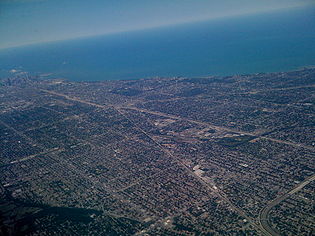
Chicago
Chicago is the largest city in the US state of Illinois. With nearly 2.7 million residents, it is the most populous city in the Midwestern United States and the third most populous in the US, after New York City and Los Angeles...
's 12,000 average.
Urban sprawl is not limited to developed countries, and may be more prevalent in developing countries. For example, there is considerable land consumed by urban sprawl in Mexico City
Mexico City
Mexico City is the Federal District , capital of Mexico and seat of the federal powers of the Mexican Union. It is a federal entity within Mexico which is not part of any one of the 31 Mexican states but belongs to the federation as a whole...
, in Beijing
Beijing
Beijing , also known as Peking , is the capital of the People's Republic of China and one of the most populous cities in the world, with a population of 19,612,368 as of 2010. The city is the country's political, cultural, and educational center, and home to the headquarters for most of China's...
, in Antananarivo
Antananarivo
Antananarivo , formerly Tananarive , is the capital and largest city in Madagascar. It is also known by its French colonial shorthand form Tana....
(the capital of Madagascar
Madagascar
The Republic of Madagascar is an island country located in the Indian Ocean off the southeastern coast of Africa...
), in Johannesburg
Johannesburg
Johannesburg also known as Jozi, Jo'burg or Egoli, is the largest city in South Africa, by population. Johannesburg is the provincial capital of Gauteng, the wealthiest province in South Africa, having the largest economy of any metropolitan region in Sub-Saharan Africa...
, and in eastern parts of South Africa
South Africa
The Republic of South Africa is a country in southern Africa. Located at the southern tip of Africa, it is divided into nine provinces, with of coastline on the Atlantic and Indian oceans...
.
Smart growth and the Compact City
The term 'smart growth' has been particularly used in North America. The terms 'compact city' or 'urban intensification' are often used to describe similar concepts, in Europe and particularly the UK where it has influenced Government policy and planning practice in recent years.
The first urban growth boundary
Urban growth boundary
An urban growth boundary, or UGB, is a regional boundary, set in an attempt to control urban sprawl by mandating that the area inside the boundary be used for higher density urban development and the area outside be used for lower density development.An urban growth boundary circumscribes an...
in the U.S. was in Fayette County, Kentucky
Fayette County, Kentucky
Fayette County is a county located in the U.S. state of Kentucky. The population was 295,083 in the 2010 Census. Its territory, population and government are coextensive with the city of Lexington, which also serves as county seat....
in 1958. Fifteen years later, the state of Oregon
Oregon
Oregon is a state in the Pacific Northwest region of the United States. It is located on the Pacific coast, with Washington to the north, California to the south, Nevada on the southeast and Idaho to the east. The Columbia and Snake rivers delineate much of Oregon's northern and eastern...
enacted a law in 1973 limiting the area urban areas could occupy, through urban growth boundaries. As a result, Portland
Portland, Oregon
Portland is a city located in the Pacific Northwest, near the confluence of the Willamette and Columbia rivers in the U.S. state of Oregon. As of the 2010 Census, it had a population of 583,776, making it the 29th most populous city in the United States...
, the state's largest urban area, has become a leader in smart growth
Smart growth
Smart growth is an urban planning and transportation theory that concentrates growth in compact walkable urban centers to avoid sprawl and advocates compact, transit-oriented, walkable, bicycle-friendly land use, including neighborhood schools, complete streets, and mixed-use development with a...
policies that seek to make urban areas more compact (they are called urban consolidation policies). After the creation of this boundary, the population density of the urbanized area increased somewhat (from 1,135 in 1970 to 1,290 per km² in 2000) USA Urbanized Areas 1950-1990 USA Urbanized Areas 2000. While the growth boundary has not been tight enough to vastly increase density, the consensus is that the growth boundaries have protected great amounts of wild areas and farmland
Farmland preservation
Farmland preservation is a joint effort by non-governmental organizations and local governments to set aside and protect examples of a region's farmland for the use, education, and enjoyment of future generations...
around the metro area.
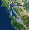
Many parts of the San Francisco Bay Area have also adopted urban growth boundaries; 25 of its cities and 5 of its counties have urban growth boundaries. Many of these were adopted with the support and advocacy of Greenbelt Alliance
Greenbelt Alliance
Greenbelt Alliance is a non-profit land conservation and urban planning organization that has worked in California's nine-county San Francisco Bay Area since 1958....
, a non-profit land conservation and urban planning organization.
In other areas, the design principles of District Regionalism
District Regionalism
District Regionalism is a finance related urban planning method. The practice creates a neighborhood stock system in which community shares are sold. The term "District Regionalism" was initially used by the administration of the city of Guthrie, Kentucky in describing the city as traits of each...
and New Urbanism
New urbanism
New Urbanism is an urban design movement, which promotes walkable neighborhoods that contain a range of housing and job types. It arose in the United States in the early 1980s, and has gradually continued to reform many aspects of real estate development, urban planning, and municipal land-use...
have been employed to combat urban sprawl.
Transit-, bicycling- and pedestrian-oriented developments
These three developments are compatible.Transit-oriented development
While cities such as Los AngelesLos Ángeles
Los Ángeles is the capital of the province of Biobío, in the commune of the same name, in Region VIII , in the center-south of Chile. It is located between the Laja and Biobío rivers. The population is 123,445 inhabitants...
are well known for sprawling suburbs, policies and public opinion are changing. Transit-oriented development, in which higher-density mixed-use areas are permitted or encouraged near transit stops is encouraging more compact development in certain areas-particularly those with light and heavy heavy rail transit systems.
Bicycling-oriented development (BOD)
Bicycles are the preferred means of travel in many countries. Also, bicycles are permitted in public transit. Businesses in areas of some towns where bicycle use is high are thriving. Bicycles and transit are contributing in two important ways toward the success of businesses:- First, is that on average the people living the closest to these business districts have more money to spend locally because they don’t spend as much on their cars.
- Second, because these people rely more on bicycling, walking and transit than on driving, they tend to focus more of their commerce on locally-owned neighborhood businesses that are convenient for them to reach.
Pedestrian-oriented development
WalkabilityWalkability
Walkability is a measure of how friendly an area is to walking. Walkability has many health, environmental, and economic benefits. Factors influencing walkability include the presence or absence and quality of footpaths, sidewalks or other pedestrian right-of-ways, traffic and road conditions,...
is a measure of how friendly an area is to walking
Walking
Walking is one of the main gaits of locomotion among legged animals, and is typically slower than running and other gaits. Walking is defined by an 'inverted pendulum' gait in which the body vaults over the stiff limb or limbs with each step...
. Walkability has many health, environmental, and economic benefits. However, evaluating walkability is challenging because it requires the consideration of many subjective
Subjectivity
Subjectivity refers to the subject and his or her perspective, feelings, beliefs, and desires. In philosophy, the term is usually contrasted with objectivity.-Qualia:...
factors. Factors influencing walkability include the presence or absence and quality of footpath
Footpath
A Footpath is a thoroughfare intended for by pedestrians but not by motorized vehicles. The term is often for paths within an urban area that offer shorter quieter routes for pedestrians, they may also provide access to the surrounding countryside or parks...
s, sidewalk
Sidewalk
A sidewalk, or pavement, footpath, footway, and sometimes platform, is a path along the side of a road. A sidewalk may accommodate moderate changes in grade and is normally separated from the vehicular section by a curb...
s or other pedestrian right-of-ways, traffic and road conditions, land use patterns, building accessibility, and safety, among others. Walkability is an important concept in sustainable urban design
Urban design
Urban design concerns the arrangement, appearance and functionality of towns and cities, and in particular the shaping and uses of urban public space. It has traditionally been regarded as a disciplinary subset of urban planning, landscape architecture, or architecture and in more recent times has...
.
Criticisms and responses
Criticism
Arguments opposing urban sprawl run the gamut from the more concrete effects such as health and environmental issues to more abstract consequences involving neighborhood vitality.Health and environmental impact
Urban sprawl is associated with a number of negative environmental and public healthPublic health
Public health is "the science and art of preventing disease, prolonging life and promoting health through the organized efforts and informed choices of society, organizations, public and private, communities and individuals" . It is concerned with threats to health based on population health...
outcomes, with the primary result being increased dependence on automobiles.
Increased pollution and reliance on fossil fuel
In the years following World War II, when vehicle ownership was becoming widespread, public healthPublic health
Public health is "the science and art of preventing disease, prolonging life and promoting health through the organized efforts and informed choices of society, organizations, public and private, communities and individuals" . It is concerned with threats to health based on population health...
officials recommended the health benefits of suburbs due to soot and industrial fumes in the city center. However, air in modern suburbs is not necessarily cleaner than air in urban neighborhoods. In fact, the most polluted air is on crowded highways, where people in suburbs tend to spend more time. On average, suburban residents generate more per capita pollution and carbon emissions than their urban counterparts because of their increased driving.
Increase in traffic and traffic-related fatalities
A heavy reliance on automobiles increases traffic throughout the city as well as automobile crashes, pedestrian injuries, and air pollution. Motor vehicle crashes are the leading cause of death for Americans between the ages of five and twenty-four and is the leading accident-related cause for all age groups. Residents of more sprawling areas are at greater risk of dying in a car crash.Increased obesity
The American Journal of Public Health and the American Journal of Health Promotion, have both stated that there is a significant connection between sprawl, obesity, and hypertensionHypertension
Hypertension or high blood pressure is a cardiac chronic medical condition in which the systemic arterial blood pressure is elevated. What that means is that the heart is having to work harder than it should to pump the blood around the body. Blood pressure involves two measurements, systolic and...
. Many urbanists argue that this is due to less walking in sprawl-type developments. Living in a car centered culture forces inhabitants to drive everywhere, thus walking far less than their urban (and generally healthier) counterparts.
Decrease in social capital
Urban sprawl may be partly responsible for the decline in social capitalSocial capital
Social capital is a sociological concept, which refers to connections within and between social networks. The concept of social capital highlights the value of social relations and the role of cooperation and confidence to get collective or economic results. The term social capital is frequently...
in the United States. Compact neighborhoods can foster casual social interactions among neighbors, while sprawl creates barriers. Sprawl tends to replace public spaces with private spaces such as fenced-in backyards.
Decrease in land and water quantity and quality
Due to the larger area consumed by sprawling suburbs compared to urban neighborhoods, more farmland and wildlife habitats are displaced per resident. As forest cover is cleared and covered with impervious surfaces (concreteConcrete
Concrete is a composite construction material, composed of cement and other cementitious materials such as fly ash and slag cement, aggregate , water and chemical admixtures.The word concrete comes from the Latin word...
and asphalt
Asphalt
Asphalt or , also known as bitumen, is a sticky, black and highly viscous liquid or semi-solid that is present in most crude petroleums and in some natural deposits, it is a substance classed as a pitch...
) in the suburbs, rainfall is less effectively absorbed into the ground water aquifer
Aquifer
An aquifer is a wet underground layer of water-bearing permeable rock or unconsolidated materials from which groundwater can be usefully extracted using a water well. The study of water flow in aquifers and the characterization of aquifers is called hydrogeology...
s. This threatens both the quality and quantity of water supplies. Sprawl increases water pollution
Water pollution
Water pollution is the contamination of water bodies . Water pollution occurs when pollutants are discharged directly or indirectly into water bodies without adequate treatment to remove harmful compounds....
as rain water picks up gasoline
Gasoline
Gasoline , or petrol , is a toxic, translucent, petroleum-derived liquid that is primarily used as a fuel in internal combustion engines. It consists mostly of organic compounds obtained by the fractional distillation of petroleum, enhanced with a variety of additives. Some gasolines also contain...
, motor oil
Motor oil
Motor oil or engine oil is an oil used for lubrication of various internal combustion engines. The main function is to lubricate moving parts; it also cleans, inhibits corrosion, improves sealing, and cools the engine by carrying heat away from moving parts.Motor oils are derived from...
, heavy metals
Heavy metals
A heavy metal is a member of a loosely-defined subset of elements that exhibit metallic properties. It mainly includes the transition metals, some metalloids, lanthanides, and actinides. Many different definitions have been proposed—some based on density, some on atomic number or atomic weight,...
, and other pollutants in runoff
Surface runoff
Surface runoff is the water flow that occurs when soil is infiltrated to full capacity and excess water from rain, meltwater, or other sources flows over the land. This is a major component of the water cycle. Runoff that occurs on surfaces before reaching a channel is also called a nonpoint source...
from parking lots and roads. Sprawl fragments the land, which increases the risk of invasive species
Invasive species
"Invasive species", or invasive exotics, is a nomenclature term and categorization phrase used for flora and fauna, and for specific restoration-preservation processes in native habitats, with several definitions....
spreading into the remaining forest.
Increased infrastructure costs
Living in larger, more spread out spaces generally makes public services more expensive. Since carAutomobile
An automobile, autocar, motor car or car is a wheeled motor vehicle used for transporting passengers, which also carries its own engine or motor...
usage becomes endemic and public transport
Public transport
Public transport is a shared passenger transportation service which is available for use by the general public, as distinct from modes such as taxicab, car pooling or hired buses which are not shared by strangers without private arrangement.Public transport modes include buses, trolleybuses, trams...
often becomes significantly more expensive, city planners are forced to build large highway
Highway
A highway is any public road. In American English, the term is common and almost always designates major roads. In British English, the term designates any road open to the public. Any interconnected set of highways can be variously referred to as a "highway system", a "highway network", or a...
and parking
Parking
Parking is the act of stopping a vehicle and leaving it unoccupied for more than a brief time. Parking on one or both sides of a road is commonly permitted, though often with restrictions...
infrastructure
Infrastructure
Infrastructure is basic physical and organizational structures needed for the operation of a society or enterprise, or the services and facilities necessary for an economy to function...
, which in turn decreases taxable land and revenue, and decreases the desirability of the area adjacent to such structures. Providing services such as water
Water supply
Water supply is the provision of water by public utilities, commercial organisations, community endeavours or by individuals, usually via a system of pumps and pipes...
, sewer
Sanitary sewer
A sanitary sewer is a separate underground carriage system specifically for transporting sewage from houses and commercial buildings to treatment or disposal. Sanitary sewers serving industrial areas also carry industrial wastewater...
s, and electricity
Electricity
Electricity is a general term encompassing a variety of phenomena resulting from the presence and flow of electric charge. These include many easily recognizable phenomena, such as lightning, static electricity, and the flow of electrical current in an electrical wire...
is also more expensive per household in less dense areas.
Increased personal transportation costs
Residents of low-density areas spend a higher proportion of their income on transportation than residents of high density areas. The RACRAC plc
RAC Limited is a breakdown company in the United Kingdom supplying products and services for motorists. Initially formed as the "Associate Section" of the Royal Automobile Club, it was incorporated as R.A.C. Motoring Services Ltd. in 1978. It was then sold by the members of the Royal Automobile...
estimates that the average cost
Average cost
In economics, average cost or unit cost is equal to total cost divided by the number of goods produced . It is also equal to the sum of average variable costs plus average fixed costs...
of operating a car in the UK is £5,000 a year, most of which stems from financing costs and depreciation. In comparison, a yearly underground
London Underground
The London Underground is a rapid transit system serving a large part of Greater London and some parts of Buckinghamshire, Hertfordshire and Essex in England...
ticket for a suburban commuter in London (where the average wage is higher than the national average ) costs £1,000-1,500, which, because of subsidies, do not cover financing for the rail or depreciation of the infrastructure. In the Euro-15, rail transit requires $69 billion euro in subsidies while road transportation nets $107 billion euro in additional taxes.
Neighborhood quality
Critics of sprawl maintain that quality of life is eroded by lifestyles promoted by sprawl promotes. Duany and Plater-Zyberk believe that in traditional neighborhoods the nearness of the workplace to retail and restaurant space that provides cafes and convenience storeConvenience store
A convenience store, corner store, corner shop, commonly called a bodega in Spanish-speaking areas of the United States, is a small store or shop in a built up area that stocks a range of everyday items such as groceries, toiletries, alcoholic and soft drinks, and may also offer money order and...
s with daytime customers is an essential component to the successful balance of urban life. Furthermore, they state that the closeness of the workplace to homes also gives people the option of walking or riding a bicycle to work or school and that without this kind of interaction between the different components of life the urban pattern quickly falls apart. (Duany Plater-Zyberk 6, 28). James Howard Kunstler
James Howard Kunstler
James Howard Kunstler is an American author, social critic, public speaker, and blogger. He is best known for his books The Geography of Nowhere , a history of American suburbia and urban development, and the more recent The Long Emergency , where he argues that declining oil production is likely...
has argued that poor aesthetics
Aesthetics
Aesthetics is a branch of philosophy dealing with the nature of beauty, art, and taste, and with the creation and appreciation of beauty. It is more scientifically defined as the study of sensory or sensori-emotional values, sometimes called judgments of sentiment and taste...
in suburban environments make them "places not worth caring about", and that they lack a sense of history and identity.
White flight
Some blame suburbs for what they see as a homogeneity of society and culture, leading to sprawling suburban developments of people with similar race, background and socioeconomic statusSocioeconomic status
Socioeconomic status is an economic and sociological combined total measure of a person's work experience and of an individual's or family’s economic and social position in relation to others, based on income, education, and occupation...
. They claim that segregated and stratified development was institutionalized in the early 1950s and 1960s with the financial industries' then-legal process of redlining
Redlining
Redlining is the practice of denying, or increasing the cost of services such as banking, insurance, access to jobs, access to health care, or even supermarkets to residents in certain, often racially determined, areas. The term "redlining" was coined in the late 1960s by John McKnight, a...
neighborhoods to prevent certain people from entering and residing in affluent districts. Sprawl may have a negative impact on public schools as finances have been pulled out of city cores and diverted to wealthier suburbs. They argue that the residential and social segregation of whites from blacks in the United States creates a socialization process that limits whites' chances for developing meaningful relationships with blacks and other minorities, and that the segregation experienced by whites from blacks fosters segregated lifestyles and can lead to positive views about themselves and negative views about blacks.
Groups that oppose sprawl
The American Institute of ArchitectsAmerican Institute of Architects
The American Institute of Architects is a professional organization for architects in the United States. Headquartered in Washington, D.C., the AIA offers education, government advocacy, community redevelopment, and public outreach to support the architecture profession and improve its public image...
and the American Planning Association
American Planning Association
The American Planning Association is a professional organization representing the field of city and regional planning in the United States. The APA was formed in 1978 when two separate professional planning organizations, the American Institute of Planners and the American Society of Planning...
recommend against sprawl and instead endorses smart
Smart growth
Smart growth is an urban planning and transportation theory that concentrates growth in compact walkable urban centers to avoid sprawl and advocates compact, transit-oriented, walkable, bicycle-friendly land use, including neighborhood schools, complete streets, and mixed-use development with a...
, mixed-use development
Mixed-use development
Mixed-use development is the use of a building, set of buildings, or neighborhood for more than one purpose. Since the 1920s, zoning in some countries has required uses to be separated. However, when jobs, housing, and commercial activities are located close together, a community's transportation...
, including buildings in close proximity to one another that cut down on automobile use, save energy, and promote walkable, healthy, well-designed neighborhoods. The Sierra Club
Sierra Club
The Sierra Club is the oldest, largest, and most influential grassroots environmental organization in the United States. It was founded on May 28, 1892, in San Francisco, California, by the conservationist and preservationist John Muir, who became its first president...
, the San Francisco Bay Area's Greenbelt Alliance
Greenbelt Alliance
Greenbelt Alliance is a non-profit land conservation and urban planning organization that has worked in California's nine-county San Francisco Bay Area since 1958....
, and other environmental organizations oppose sprawl and support investment in existing communities. NumbersUSA
NumbersUSA
NumbersUSA is an immigration reduction organization that seeks to reduce US immigration levels to pre-1965 levels without country of origin quotas as established in the Immigration Act of 1924. It advocates for immigration reduction through user-generated fax, email, and direct mail campaigns...
, a national organization advocating immigration reduction
Immigration reduction
Immigration reduction refers to a movement in the United States that advocates a reduction in the amount of immigration allowed into the country. Steps advocated for reducing the numbers of immigrants include advocating stronger action to prevent illegal entry and illegal immigration, and...
, also opposes urban sprawl, and its executive director, Roy Beck
Roy Beck
Roy Beck is a former journalist and public policy analyst who has served as the Executive Director of NumbersUSA since 1997. Beck was a journalist for three decades before founding NumbersUSA. He is former Washington D. C. bureau chief of Booth Newspapers and one of the nation's first...
, specializes in the study of this issue.
Responses
AmericanUnited States
The United States of America is a federal constitutional republic comprising fifty states and a federal district...
public policy
Public policy
Public policy as government action is generally the principled guide to action taken by the administrative or executive branches of the state with regard to a class of issues in a manner consistent with law and institutional customs. In general, the foundation is the pertinent national and...
analyst Randal O'Toole
Randal O'Toole
Randal O'Toole is an American public policy analyst. Although O'Toole studied economics at the University of Oregon, he did not receive a degree in economics...
of the Cato Institute
Cato Institute
The Cato Institute is a libertarian think tank headquartered in Washington, D.C. It was founded in 1977 by Edward H. Crane, who remains president and CEO, and Charles Koch, chairman of the board and chief executive officer of the conglomerate Koch Industries, Inc., the largest privately held...
, a libertarian think tank
Think tank
A think tank is an organization that conducts research and engages in advocacy in areas such as social policy, political strategy, economics, military, and technology issues. Most think tanks are non-profit organizations, which some countries such as the United States and Canada provide with tax...
, has argued that sprawl, thanks to the automobile, gave rise to affordable suburban neighborhoods for middle class and lower class individuals, including non-whites. He notes that efforts to combat sprawl often result in subsidizing development in wealthier and whiter neighborhoods while condemning and demolishing poorer minority neighborhoods.
Consumer preference for sprawl
Peter Gordon, a professor of planning and economics at the University of Southern California's School of Urban Planning and Development, argues that many households in the United States, Canada, and Australia, especially middle and upper classUpper class
In social science, the "upper class" is the group of people at the top of a social hierarchy. Members of an upper class may have great power over the allocation of resources and governmental policy in their area.- Historical meaning :...
families, have shown a preference for the suburban lifestyle. Reasons cited include a preference towards lower-density development (for lower ambient noise and increased privacy), better schools, less crime, and a generally slower lifestyle than the urban one. Those in favor of the current pro low-density land use policies also argue that this sort of living situation is an issue of personal choice and economic means. One suburban Detroit politician defends low-density development as the preferred lifestyle choice of his constituents, calling it "...the American Dream unfolding before your eyes."
Urban Sprawl and automobile dependency
Whether urban sprawl does increase problems of automobile dependencyAutomobile dependency
Automobile dependency is a term coined by Professors Peter Newman and Jeff Kenworthy to capture the predicament of most cities in the United States, Canada, Australia and New Zealand, and to a lesser extent, large cities in Europe....
and whether conversely, policies of smart growth
Smart growth
Smart growth is an urban planning and transportation theory that concentrates growth in compact walkable urban centers to avoid sprawl and advocates compact, transit-oriented, walkable, bicycle-friendly land use, including neighborhood schools, complete streets, and mixed-use development with a...
can reduce them have been fiercely contested issues over several decades. An influential study in 1989 by Peter Newman
Peter Newman
Peter Newman may refer to:*Peter C. Newman, Canadian journalist who emigrated from Nazi-occupied Czechoslovakia*Peter Kenneth Newman , English economist, historian of economic thought*Peter R...
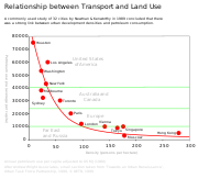
and Jeff Kenworthy compared 32 cities across North America, Australia, Europe and Asia. The study has been criticised for its methodology but the main finding that denser cities, particularly in Asia, have lower car use than sprawling cities, particularly in North America, has been largely accepted although the relationship is clearer at the extremes across continents than it is within countries where conditions are more similar.
Within cities, studies from across many countries (mainly in the developed world) have shown that denser urban areas with greater mixture of land use and better public transport tend to have lower car use than less dense suburban and ex-urban residential areas. This usually holds true even after controlling for socio-economic factors such as differences in household composition and income. This does not necessarily imply that suburban sprawl causes high car use, however. One confounding factor, which has been the subject of many studies, is residential self-selection: people who prefer to drive tend to move towards low density suburbs, whereas people who prefer to walk, cycle or use transit tend to move towards higher density urban areas, better served by public transport. Some studies have found that, when self-selection is controlled for, the built environment has no significant effect on travel behaviour. More recent studies using more sophisticated methodologies have generally refuted these findings: density, land use and public transport accessibility can influence travel behaviour, although social and economic factors, particularly household income, usually exert a stronger influence.
The Paradox of Intensification
Reviewing the evidence on urban intensification, smart growthSmart growth
Smart growth is an urban planning and transportation theory that concentrates growth in compact walkable urban centers to avoid sprawl and advocates compact, transit-oriented, walkable, bicycle-friendly land use, including neighborhood schools, complete streets, and mixed-use development with a...
and their effects on travel behaviour Melia et al. (2011) found support for the arguments of both supporters and opponents of smart growth
Smart growth
Smart growth is an urban planning and transportation theory that concentrates growth in compact walkable urban centers to avoid sprawl and advocates compact, transit-oriented, walkable, bicycle-friendly land use, including neighborhood schools, complete streets, and mixed-use development with a...
measures to counteract urban sprawl. Planning policies that increase population densities in urban areas do tend to reduce car use, but the effect is a weak one, so doubling the population density of a particular area will not halve the frequency or distance of car use.
These findings led them to propose the paradox of intensification, which states:
'
Debate over traffic and commute times
Those not opposed to low density development argue that traffic intensities tend to be less, traffic speeds faster and, as a result, ambient air pollutionAir pollution
Air pollution is the introduction of chemicals, particulate matter, or biological materials that cause harm or discomfort to humans or other living organisms, or cause damage to the natural environment or built environment, into the atmosphere....
is lower. (See demographia's report.) Kansas City, Missouri
Kansas City, Missouri
Kansas City, Missouri is the largest city in the U.S. state of Missouri and is the anchor city of the Kansas City Metropolitan Area, the second largest metropolitan area in Missouri. It encompasses in parts of Jackson, Clay, Cass, and Platte counties...
is often cited as an example of ideal low-density development, with congestion below the mean and home prices
Real estate pricing
Real estate pricing deals with the valuation of real estate and all the standard methods of determining the price of fixed assets apply....
below comparable Midwestern cities. Wendell Cox
Wendell Cox
Wendell Cox is an international public policy consultant. He is the principal and sole owner of Wendell Cox Consultancy/Demographia, based in the St. Louis metropolitan region and editor of three web sites, Demographia, The Public Purpose and Urban Tours by Rental Car...
and Randal O'Toole
Randal O'Toole
Randal O'Toole is an American public policy analyst. Although O'Toole studied economics at the University of Oregon, he did not receive a degree in economics...
are the leading figures supporting lower density development.
Longitudinal (time-lapse) studies of commute times in major metropolitan areas in the United States have shown that commute times decreased for the period 1969 to 1995 even though the geographic size of the city increased.
Risk of increased housing prices
There is also some concern that Portland-style anti-sprawl policies will increase housing prices. Some research suggests Oregon has had the largest housing affordability loss in the nation, but other research shows that Portland's price increases are comparable to other Western cities.In Australia, it is claimed by some that housing affordability has hit "crisis levels" due to "urban consolidation" policies implemented by state governments. In Sydney, the ratio of the price of a house relative to income is 9:1. The issue has at times been debated between the major political parties.
Freedom
There are some sociologists such as Durkheim who suggest there is a link between population density and the number of rules that must be imposed. The theory goes that as people are moved closer together geographically their actions are more likely to noticeably impact others around them. This potential impact requires the creation of additional social or legal rules to prevent conflict. A simple example would be as houses become closer together the acceptable maximum volume of music decreases, as it becomes intrusive to other residents.Crowding and increased aggression
Numerous studies link increased population density with increased aggression. Some people believe that increased population density encourages crime and anti-social behavior. It is argued that human beings, while social animals, need significant amounts of social space or they become agitated and aggressive.However, the relationship between higher densities and increased social pathology has been largely discredited
The Role of the Active Transportation Network
One solution to the dilemma posed by the ubiquitous expansion of suburban sprawl is the potential for the development of the active transportation network. Cities such as Seattle where the 42 mi (67.6 km) Burke-GilmanBurke-Gilman Trail
The Burke-Gilman Sammamish Trail is a rail trail in King County, Washington. The multi-use recreational trail is part of the King County Regional Trail System and occupies an abandoned Seattle, Lake Shore and Eastern Railway corridor....
multi-use trail has been in use for over 30 years have seen a significant number of commuters utilize the network for long distance travel both with human-powered and increasingly with electric-assist mobility aids (e-bikes). The dual benefits of exercise and mobility may contribute to a mitigation of the negative effects of sprawl in areas where the active transportation network is adequately developed. The opportunity to load bicycles onto public transit allows such a network to function even during inclement weather and provides a new hope for those metropolitan areas where available rights-of-way and greenbelt lands still exist for the development of the active transportation network.
Urban sprawl in nonfiction
- Crabgrass Frontier: The Suburbanization of the United StatesCrabgrass Frontier: The Suburbanization of the United StatesCrabgrass Frontier: The Suburbanization of the United States is a book written by Kenneth T. Jackson. Published in 1985, it analyzes the development of American suburbs from their origins in the early 19th century. Jackson examines how a high quality of life in America came to be equated with home...
by Kenneth T. JacksonKenneth T. JacksonKenneth Terry Jackson is a professor of history and social sciences at Columbia University. A frequent television guest, he is best known as an urban historian and a preeminent authority on New York City, where he lives on the Upper West Side.... - The Death and Life of Great American CitiesThe Death and Life of Great American CitiesThe Death and Life of Great American Cities, by Jane Jacobs, is a greatly influential book on the subject of urban planning in the 20th century...
by Jane JacobsJane JacobsJane Jacobs, was an American-Canadian writer and activist with primary interest in communities and urban planning and decay. She is best known for The Death and Life of Great American Cities , a powerful critique of the urban renewal policies of the 1950s in the United States... - Edge CityEdge city"Edge city" is an American term for a concentration of business, shopping, and entertainment outside a traditional urban area in what had recently been a residential suburb or semi-rural community...
: Life on the New Frontier by Garreau, JoelJoel GarreauJoel Garreau is an American journalist, scholar and author of Radical Evolution: The Promise and Peril of Enhancing Our Minds, Our Bodies – And What It Means to Be Human, Edge City: Life on the New Frontier and The Nine Nations of North America.In 2010, Garreau became the Lincoln Professor of Law,...
, Anchor Books/Doubleday New York. - Fast Food NationFast Food NationFast Food Nation: The Dark Side of the All-American Meal is a book by investigative journalist Eric Schlosser that examines the local and global influence of the United States fast food industry....
by Eric SchlosserEric SchlosserEric Schlosser is an American journalist and author known for investigative journalism, such as in his books Fast Food Nation, Reefer Madness and Chew On This.- Personal History :... - The Future of Success: Working and Living in the New Economy by Robert Reich
- The Geography of NowhereThe Geography of NowhereThe Geography of Nowhere: The Rise and Decline of America's Man-Made Landscape is a book written in 1993 by James Howard Kunstler exploring the effects of suburban sprawl, civil planning and the automobile on American society. The book is an attempt to discover how and why suburbia has ceased to...
: The rise and decline of America's man-made landscape (ISBN 0-671-70774-4) by J.H. Kunstler - The Old Neighborhood: What we lost in the great suburban migration: 1966-1999 by Ray SuarezRay SuarezRafael Suarez, Jr. , known as Ray Suarez, is an American broadcast journalist. Suarez joined the PBS NewsHour in 1999 and became a senior correspondent for the evening news program on the PBS television network. He is also host of the international news and analysis public radio program America...
- A Field Guide to Sprawl by Dolores HaydenDolores HaydenDolores Hayden is an American professor, urban historian, architect, author, and poet. She teaches architecture, urbanism, and American studies at Yale University.-Background:...
and Jim Wark, ISBN 0-393-73125-1, W. W. Norton & Company. - Radiant CityRadiant CityRadiant City is a National Film Board of Canada filmreleased in 2006 at the Toronto Film Festival, about suburban sprawl and the fictional Moss family who live in the suburbs, written and directed by Gary Burns and Jim Brown....
, is a 2006 National Film Board of CanadaNational Film Board of CanadaThe National Film Board of Canada is Canada's twelve-time Academy Award-winning public film producer and distributor. An agency of the Government of Canada, the NFB produces and distributes documentary, animation, alternative drama and digital media productions...
documentary on suburban sprawl - Sprawl: A Compact History by Robert Bruegmann, University of Chicago PressUniversity of Chicago PressThe University of Chicago Press is the largest university press in the United States. It is operated by the University of Chicago and publishes a wide variety of academic titles, including The Chicago Manual of Style, dozens of academic journals, including Critical Inquiry, and a wide array of...
, hardcover, 301 pages, ISBN 0-226-07690-3 - "Sprawl Kills - How Blandburbs Steal Your Time, Health and Money," by Joel S. Hirschhorn
- Suburban Nation: The rise of sprawl and the decline of the American Dream (ISBN 0-86547-606-3) by A. DuanyAndrés DuanyAndrés Duany is an American architect and urban planner.Duany was born in New York City but grew up in Cuba until 1960. He attended The Choate School and received his undergraduate degree in architecture and urban planning from Princeton University...
, E. Plater-ZyberkElizabeth Plater-ZyberkElizabeth Plater-Zyberk is an American architect and urban planner of Polish aristocratic roots based in Miami, Florida...
, and Jeff Speck
Related topics
- Compact CityCompact CityThe Compact City or city of short distances is an urban planning and urban design concept, which promotes relatively high residential density with mixed land uses. It is based on an efficient public transport system and has an urban layout which – according to its advocates – encourages walking and...
- Effects of the automobile on societiesEffects of the automobile on societiesOver the course of the 20th century, the automobile rapidly developed from an expensive toy for the rich into the de facto standard for passenger transport in most developed countries. In developing countries, the effects of the automobile have lagged, but are emulating the impacts of developed...
- GentrificationGentrificationGentrification and urban gentrification refer to the changes that result when wealthier people acquire or rent property in low income and working class communities. Urban gentrification is associated with movement. Consequent to gentrification, the average income increases and average family size...
- Great American Streetcar Scandal
- List of urban studies topics
- New PedestrianismNew pedestrianismNew Pedestrianism is a more idealistic variation of New Urbanism in urban planning theory, founded in 1999 by Michael E. Arth, an American artist, urban/home/landscape designer, futurist, and author...
- Principles of Intelligent UrbanismPrinciples of Intelligent UrbanismPrinciples of Intelligent Urbanism is a theory of urban planning composed of a set of ten axioms intended to guide the formulation of city plans and urban designs. They are intended to reconcile and integrate diverse urban planning and management concerns...
- Rural-urban fringe
- Smart GrowthSmart growthSmart growth is an urban planning and transportation theory that concentrates growth in compact walkable urban centers to avoid sprawl and advocates compact, transit-oriented, walkable, bicycle-friendly land use, including neighborhood schools, complete streets, and mixed-use development with a...
- Town centreTown centreThe town centre is the term used to refer to the commercial or geographical centre or core area of a town.Town centres are traditionally associated with shopping or retail. They are also the centre of communications with major public transport hubs such as train or bus stations...
- Urban planningUrban planningUrban planning incorporates areas such as economics, design, ecology, sociology, geography, law, political science, and statistics to guide and ensure the orderly development of settlements and communities....
Related terminology
- AffluenzaAffluenzaAffluenza, from affluence and influenza, is a term used by critics of capitalism and consumerism. Sources define it as follows:Proponents of the term consider that the prizing of endless increases in material wealth may lead to feelings of worthlessness and dissatisfaction rather than experiences...
- BoomburbBoomburbBoomburb is a neologism for a large, rapidly growing city that remains essentially suburban in character even as it reaches populations more typical of urban core cities...
- Commuter townCommuter townA commuter town is an urban community that is primarily residential, from which most of the workforce commutes out to earn their livelihood. Many commuter towns act as suburbs of a nearby metropolis that workers travel to daily, and many suburbs are commuter towns...
- Concentric zone modelConcentric zone modelThe Concentric zone model also known as the Burgess model is one of the earliest theoretical models to explain urban social structures. It was created by sociologist Ernest Burgess in 1924. -The model:...
- Conspicuous consumptionConspicuous consumptionConspicuous consumption is spending on goods and services acquired mainly for the purpose of displaying income or wealth. In the mind of a conspicuous consumer, such display serves as a means of attaining or maintaining social status....
- ConsumerismConsumerismConsumerism is a social and economic order that is based on the systematic creation and fostering of a desire to purchase goods and services in ever greater amounts. The term is often associated with criticisms of consumption starting with Thorstein Veblen...
- DeforestationDeforestationDeforestation is the removal of a forest or stand of trees where the land is thereafter converted to a nonforest use. Examples of deforestation include conversion of forestland to farms, ranches, or urban use....
- DemographicsDemographicsDemographics are the most recent statistical characteristics of a population. These types of data are used widely in sociology , public policy, and marketing. Commonly examined demographics include gender, race, age, disabilities, mobility, home ownership, employment status, and even location...
- Edge cityEdge city"Edge city" is an American term for a concentration of business, shopping, and entertainment outside a traditional urban area in what had recently been a residential suburb or semi-rural community...
- Garden real estateGarden real estateA category in the niche real estate market containing property with good gardens. The market can be sub-classified as follows:* Property with gardens by well-known Landscape designers. This is normally the work of designers whose work has been published in books and magazines...
- GentrificationGentrificationGentrification and urban gentrification refer to the changes that result when wealthier people acquire or rent property in low income and working class communities. Urban gentrification is associated with movement. Consequent to gentrification, the average income increases and average family size...
- Global population
- Habitat fragmentationHabitat fragmentationHabitat fragmentation as the name implies, describes the emergence of discontinuities in an organism's preferred environment , causing population fragmentation...
- Induced demandInduced demandInduced demand, or latent demand, is the phenomenon that after supply increases, more of a good is consumed. This is entirely consistent with the economic theory of supply and demand; however, this idea has become important in the debate over the expansion of transportation systems, and is often...
- Landscape ecologyLandscape ecologyLandscape ecology is the science of studying and improving relationships between urban development and ecological processes in the environment and particular ecosystems...
- Location Efficient MortgageLocation Efficient MortgageLocation Efficient Mortgage is a mortgage available to people who buy a home in locations where they don't need to rely on automobiles as much or at all for transportation. Location efficient mortgages allow people to buy more expensive homes than they normally would be able by factoring in the...
- MegacityMegacityA megacity is usually defined as a metropolitan area with a total population in excess of 10 million people. Some definitions also set a minimum level for population density . A megacity can be a single metropolitan area or two or more metropolitan areas that converge. The terms conurbation,...
- McMansionMcMansionMcMansion is a pejorative term for a large new house which is judged as pretentious, tasteless, or badly designed for its neighborhood. Alternately, a McMansion is a large house in a sub-division of similarly large houses, which all seem mass produced and lacking distinguishing characteristics, and...
- MicrodistrictMicrodistrictMicrodistrict, or microraion , is a residential complex—a primary structural element of the residential area construction in the Soviet Union and in some post-Soviet and former Communist states...
- Middle classMiddle classThe middle class is any class of people in the middle of a societal hierarchy. In Weberian socio-economic terms, the middle class is the broad group of people in contemporary society who fall socio-economically between the working class and upper class....
- New townNew townA new town is a specific type of a planned community, or planned city, that was carefully planned from its inception and is typically constructed in a previously undeveloped area. This contrasts with settlements that evolve in a more ad hoc fashion. Land use conflicts are uncommon in new...
- NIMBYNIMBYNIMBY or Nimby is an acronym for the phrase "not in my back yard". The term is used pejoratively to describe opposition by residents to a proposal for a new development close to them. Opposing residents themselves are sometimes called Nimbies...
- Over-consumptionOver-consumptionOver-consumption is a situation where resource-use has outpaced the sustainable capacity of the ecosystem. A prolonged pattern of overconsumption leads to inevitable environmental degradation and the eventual loss of resource bases...
- Peak oilPeak oilPeak oil is the point in time when the maximum rate of global petroleum extraction is reached, after which the rate of production enters terminal decline. This concept is based on the observed production rates of individual oil wells, projected reserves and the combined production rate of a field...
- Prime farmlandPrime farmlandPrime farmland is a designation assigned by U.S. Department of Agriculture defining land that has the best combination of physical and chemical characteristics for producing food, feed, forage, fiber, and oilseed crops and is also available for these land uses....
- Regional planningRegional planningRegional planning deals with the efficient placement of land use activities, infrastructure, and settlement growth across a larger area of land than an individual city or town. The related field of urban planning deals with the specific issues of city planning...
- Rural exodusRural exodusRural flight is a term used to describe the migratory patterns of peoples from rural areas into urban areas.In modern times, it often occurs in a region following the industrialization of agriculture when fewer people are needed to bring the same amount of agricultural output to market and related...
- Simple livingSimple livingSimple living encompasses a number of different voluntary practices to simplify one's lifestyle. These may include reducing one's possessions or increasing self-sufficiency, for example. Simple living may be characterized by individuals being satisfied with what they need rather than want...
- Spatial planningSpatial planningSpatial planning refers to the methods used by the public sector to influence the distribution of people and activities in spaces of various scales. Discrete professional disciplines which involve spatial planning include land use planning, urban planning, regional planning, transport planning and...
- Streetcar suburbStreetcar suburbA streetcar suburb is a residential community whose growth and development was strongly shaped by the use of streetcar lines as a primary means of transportation. Early suburbs were served by horsecars, but by the late 19th century cable cars and electric streetcars, or trams, were used, allowing...
- Suburbanisation
- Urban decayUrban decayUrban decay is the process whereby a previously functioning city, or part of a city, falls into disrepair and decrepitude...
Further reading
- Jackson, Kenneth T.Kenneth T. JacksonKenneth Terry Jackson is a professor of history and social sciences at Columbia University. A frequent television guest, he is best known as an urban historian and a preeminent authority on New York City, where he lives on the Upper West Side....
. Crabgrass Frontier: The Suburbanization of the United StatesCrabgrass Frontier: The Suburbanization of the United StatesCrabgrass Frontier: The Suburbanization of the United States is a book written by Kenneth T. Jackson. Published in 1985, it analyzes the development of American suburbs from their origins in the early 19th century. Jackson examines how a high quality of life in America came to be equated with home...
New York: Oxford University Press, 1985. - Bruegmann, Robert.Robert BruegmannRobert Bruegmann is an historian of architecture, landscape and the built environment. He is a professor at the University of Illinois at Chicago, a specialist on the Chicago school , and best known for his research on the architectural firm of Holabird & Root...
Sprawl: A Compact History. Chicago: University of Chicago Press, 2005. ISBN 0-226-07691-1 - Garreau, Joel, "Edge City: life on the new frontier". New York, Anchor Books, 1991.
- Gielen, Tristan. Coping with compaction; the demon of sprawl. Auckland, Random House New Zealand, 2006.
- Hayden, Dolores. "A Field Guide to Sprawl". New York, W. W. Norton & Co., 2004.
- Rybczynski, Witold (Nov. 7, 2005). "Suburban Despair". SlateSlate (magazine)Slate is a US-based English language online current affairs and culture magazine created in 1996 by former New Republic editor Michael Kinsley, initially under the ownership of Microsoft as part of MSN. On 21 December 2004 it was purchased by the Washington Post Company...
. - Vicino, Thomas, J. Transforming Race and Class in Suburbia: Decline in Metropolitan Baltimore. New York: Palgrave Macmillan, 2008.
- Winkler, Robert. Going Wild: Adventures with Birds in the Suburban Wilderness. Washington, D.C.: National Geographic, 2003.
External links
- Greenbelt Alliance; open space advocacy
- e-Geopolis project Research Group, University Paris-Diderot
- Smart Growth/Sprawl from the Natural Resources Defense CouncilNatural Resources Defense CouncilThe Natural Resources Defense Council is a New York City-based, non-profit, non-partisan international environmental advocacy group, with offices in Washington DC, San Francisco, Los Angeles, Chicago, and Beijing...
- Smart Growth America