

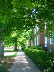
Walkability
Encyclopedia
,_montreal_2005-10-21.jpg)
Walking
Walking is one of the main gaits of locomotion among legged animals, and is typically slower than running and other gaits. Walking is defined by an 'inverted pendulum' gait in which the body vaults over the stiff limb or limbs with each step...
. Walkability has many health, environmental, and economic benefits. Factors influencing walkability include the presence or absence and quality of footpaths
Footpath
A Footpath is a thoroughfare intended for by pedestrians but not by motorized vehicles. The term is often for paths within an urban area that offer shorter quieter routes for pedestrians, they may also provide access to the surrounding countryside or parks...
, sidewalks
Sidewalk
A sidewalk, or pavement, footpath, footway, and sometimes platform, is a path along the side of a road. A sidewalk may accommodate moderate changes in grade and is normally separated from the vehicular section by a curb...
or other pedestrian right-of-ways, traffic and road conditions, land use patterns, building accessibility, and safety, among others. Walkability is an important concept in sustainable urban design
Urban design
Urban design concerns the arrangement, appearance and functionality of towns and cities, and in particular the shaping and uses of urban public space. It has traditionally been regarded as a disciplinary subset of urban planning, landscape architecture, or architecture and in more recent times has...
.
Definitions

Permeability (spatial and transport planning)
Permeability or connectivity describes the extent to which urban forms permit movement of people or vehicles in different directions. The terms are often used interchangeably, although differentiated definitions also exist...
; land use
Land use
Land use is the human use of land. Land use involves the management and modification of natural environment or wilderness into built environment such as fields, pastures, and settlements. It has also been defined as "the arrangements, activities and inputs people undertake in a certain land cover...
mix; residential density (residential units per area of residential use); "transparency" which includes amount of glass in windows and doors, as well as orientation and proximity of homes and buildings to watch over the street; plenty of places to go to near the majority of homes; placemaking, street designs that work for people, not just cars and retail floor area ratio
Floor Area Ratio
The floor area ratio or floor space index is the ratio of the total floor area of buildings on a certain location to the size of the land of that location, or the limit imposed on such a ratio....
. Major infrastructural
Infrastructure
Infrastructure is basic physical and organizational structures needed for the operation of a society or enterprise, or the services and facilities necessary for an economy to function...
factors include access to mass transit, presence and quality of footpaths, buffers to moving traffic (planter strips, on-street parking
Parking
Parking is the act of stopping a vehicle and leaving it unoccupied for more than a brief time. Parking on one or both sides of a road is commonly permitted, though often with restrictions...
or bike lanes) and pedestrian crossing
Pedestrian crossing
A pedestrian crossing or crosswalk is a designated point on a road at which some means are employed to assist pedestrians wishing to cross. They are designed to keep pedestrians together where they can be seen by motorists, and where they can cross most safely across the flow of vehicular traffic...
s, aesthetics
Aesthetics
Aesthetics is a branch of philosophy dealing with the nature of beauty, art, and taste, and with the creation and appreciation of beauty. It is more scientifically defined as the study of sensory or sensori-emotional values, sometimes called judgments of sentiment and taste...
, nearby local destinations, air quality, shade or sun in appropriate seasons, street furniture
Street furniture
Street furniture is a collective term for objects and pieces of equipment installed on streets and roads for various purposes, including traffic barriers,...
, traffic volume and speed. and wind conditions. One of the best ways to quickly determine the walkability of a block, corridor or neighborhood is to count the number of people walking, lingering and engaging in optional activities within a space. While this process is a vast improvement upon pedestrian level of service (LOS) indicators recommended within the Highway Capacity Manual, it may not translate well to non-Western locations where the idea of "optional" activities may be different. in any case, the diversity of people, and especially the presence of children, seniors and people with disabilities, denotes the quality, completeness and health of a walkable space.
Benefits
Walkability indices have been found to correlate with both Body mass indexBody mass index
The body mass index , or Quetelet index, is a heuristic proxy for human body fat based on an individual's weight and height. BMI does not actually measure the percentage of body fat. It was invented between 1830 and 1850 by the Belgian polymath Adolphe Quetelet during the course of developing...
and physical activity of local populations. Due to discrepancies between residents' health in inner city
Inner city
The inner city is the central area of a major city or metropolis. In the United States, Canada, United Kingdom and Ireland, the term is often applied to the lower-income residential districts in the city centre and nearby areas...
neighborhoods and suburb
Suburb
The word suburb mostly refers to a residential area, either existing as part of a city or as a separate residential community within commuting distance of a city . Some suburbs have a degree of administrative autonomy, and most have lower population density than inner city neighborhoods...
an neighborhoods with similar walkability measures, it has been suggested that further research is needed to find additional built environment
Built environment
The term built environment refers to the human-made surroundings that provide the setting for human activity, ranging in scale from personal shelter and buildings to neighborhoods and cities that can often include their supporting infrastructure, such as water supply or energy networks.The built...
factors to be included in walkability indices.
Increased walkability has proven to have many other individual and community health benefits, such as opportunities for increased social interaction, an increase in the average number of friends and associates where people live, reduced crime (with more people walking and watching over neighborhoods, open space and main streets), increased sense of pride, and increased volunteerism. One of most important benefits of walkability is the decrease of the automobile footprint in the community. Carbon emissions can be reduced if more people choose to walk rather than drive. Walkability has also been found to have many economic benefits, including accessibility, cost savings both to individuals and to the public, increased efficiency of land use, increased livability, economic benefits from improved public health, and economic development, among others.
The World Cancer Research Fund
World Cancer Research Fund
World Cancer Research Fund International is a not-for-profit association, established by royal decree in Belgium, with headquarters in London, UK...
and American Institute for Cancer Research
American Institute for Cancer Research
The American Institute for Cancer Research is a large American cancer research organization associated with the World Cancer Research Fund umbrella organization.Its stated mission is:...
released a report that new developments should be designed to encourage walking, on the grounds that walking contributes to a reduction of cancer.
Community planning
Pedestrian
A pedestrian is a person traveling on foot, whether walking or running. In some communities, those traveling using roller skates or skateboards are also considered to be pedestrians. In modern times, the term mostly refers to someone walking on a road or footpath, but this was not the case...
mobility as an alternative to older building practices that favor automobiles. Reasons for this shift include a belief that dependency on automobiles is ecologically unsustainable, automobile-oriented environments engender dangerous conditions to both motorists and pedestrians and are generally bereft of aesthetics.
Auto-focused designs also diminish walking and needed "eyes on the street" provided by the steady presence of people in an area. Reduced walking also reduces social interaction, mixing of populations and pride in streets and other civic space.
There are several ways to make a community more walkable. Sidewalks should be implemented where there are "sidewalk gaps" with priority to areas where walking should be encouraged, like around schools or transit stations. When implementing new sidewalks, there are several aspects to consider. For example, the width of the sidewalk is important for walkability. The Americans with Disabilities Act (ADA) requires that sidewalks be at least five feet in width. Obstructions like sign posts and utility poles can decrease the walkable width of the sidewalk, so alternative locations for these obstructions, especially sign posts, should be used. Quality maintenance and proper lighting of sidewalks should be sustained to reduce obstructions, improve safety, and overall encourage walking. Another way to make sidewalks safer is to implement buffers, which are areas of grass between the street and the sidewalk. An additional benefit of buffers is that the vegetation absorbs the carbon dioxide from automobile emissions and assists with water drainage.
Making crosswalks safer is also key to walkability. Curb extension
Curb extension
A curb extension is a traffic calming measure, primarily used to extend the sidewalk, reducing the crossing distance and allowing pedestrians about to cross and approaching vehicle drivers to see each other when vehicles...
s decrease the radii of the corners of the curb at intersections. Curb extensions calm traffic and decrease the distance pedestrians have to cross. On streets with parking, curb extensions allow pedestrians to see oncoming traffic better where they would be forced to walk into the street to see past parked cars otherwise. Striped crosswalks, or zebra crossing
Zebra crossing
A zebra crossing is a type of pedestrian crossing used in many places around the world. Its distinguishing feature is alternating dark and light stripes on the road surface, from which it derives its name. A zebra crossing typically gives extra rights of way to pedestrians.The use of zebra...
s, also provide safer crossings because they provide better visibility for both drivers and pedestrians.
A principal justification for walkability, as a consideration in urban design
Urban design
Urban design concerns the arrangement, appearance and functionality of towns and cities, and in particular the shaping and uses of urban public space. It has traditionally been regarded as a disciplinary subset of urban planning, landscape architecture, or architecture and in more recent times has...
and planning
Urban planning
Urban planning incorporates areas such as economics, design, ecology, sociology, geography, law, political science, and statistics to guide and ensure the orderly development of settlements and communities....
, is founded upon evolutionary and philosophical grounds, contending that gait has been vital to the cerebral development in humans. After millennia of human development firmly based upon gait, twentieth century automotive and automated metropolis has separated between walking and thinking, and in this sense it has become an agent of regression rather than human progress. Walkability, therefore, is offered as a critical component in contemporary urban design
Urban design
Urban design concerns the arrangement, appearance and functionality of towns and cities, and in particular the shaping and uses of urban public space. It has traditionally been regarded as a disciplinary subset of urban planning, landscape architecture, or architecture and in more recent times has...
considerations, with implications far beyond the scope of current concerns.
Measuring walkability
One way of assessing and measuring walkability is to undertake a walking auditWalking audit
A walking audit is an assessment of the walkability or pedestrian access of an external environment. Walking audits are often undertaken in street environments to consider and promote the needs of pedestrians as a form of transport...
. An established and widely used walking audit tool is PERS (Pedestrian Environment Review System) which has been used extensively in the UK.
Walk Score is an algorithmically derived walkability index based on the distance to the closest amenity in each of several categories, but does not consider factors such as sidewalk availability, safety of the neighborhood, and topography.
Walkonomics is a web-app that combines Open Data
Open Data
Open data is the idea that certain data should be freely available to everyone to use and republish as they wish, without restrictions from copyright, patents or other mechanisms of control. The goals of the open data movement are similar to those of other "Open" movements such as open source, open...
and Crowdsourcing
Crowdsourcing
Crowdsourcing is the act of sourcing tasks traditionally performed by specific individuals to a group of people or community through an open call....
to rate and review the walkability of each street. So far every street in England (over 600,000 streets) and New York City have been rated.
RateMyStreet is a website that uses Crowdsourcing
Crowdsourcing
Crowdsourcing is the act of sourcing tasks traditionally performed by specific individuals to a group of people or community through an open call....
, Google Maps
Google Maps
Google Maps is a web mapping service application and technology provided by Google, free , that powers many map-based services, including the Google Maps website, Google Ride Finder, Google Transit, and maps embedded on third-party websites via the Google Maps API...
and a five star rating system to empower local communities to rate the walkability of their local streets. Users can rate a street using eight different categories: Crossing the street, Pavement/Sidewalk width, Trip hazards, Wayfinding, Safety from crime, Road safety, Clean/attractive and disabled peoples access.
See also
- Bicycle-friendlyBicycle-friendlyThe term bicycle-friendly describes policies and practices which may help some people feel more comfortable about traveling by bicycle with other traffic...
- New PedestrianismNew pedestrianismNew Pedestrianism is a more idealistic variation of New Urbanism in urban planning theory, founded in 1999 by Michael E. Arth, an American artist, urban/home/landscape designer, futurist, and author...
- New Urban Cowboy: Toward a New Pedestrianism
- New UrbanismNew urbanismNew Urbanism is an urban design movement, which promotes walkable neighborhoods that contain a range of housing and job types. It arose in the United States in the early 1980s, and has gradually continued to reform many aspects of real estate development, urban planning, and municipal land-use...
- Pedestrian villagePedestrian VillageA pedestrian village is a compact, pedestrian-oriented neighborhood or town, with a mixed-use village center, that follows the tenets of New Pedestrianism. Shared-use lanes for pedestrians and those using bicycles, Segways, wheelchairs, and other small rolling conveyances that do not use internal...
- Permeability (spatial and transport planning)Permeability (spatial and transport planning)Permeability or connectivity describes the extent to which urban forms permit movement of people or vehicles in different directions. The terms are often used interchangeably, although differentiated definitions also exist...
- Walking auditWalking auditA walking audit is an assessment of the walkability or pedestrian access of an external environment. Walking audits are often undertaken in street environments to consider and promote the needs of pedestrians as a form of transport...
Further reading
- Stephanie Y. Rauterkus, Grant I. Thrall, and Eric Hangen, 2010. “Location Efficiency and Mortgage Default” Journal of Sustainable Real Estate (JOSRE), Volume 2, No. 1.
- Rogers, Shannon H., John M. Halstead, Kevin H. Gardner and Cynthia H. Carlson. 2010. “Examining Walkability and Social Capital as Indicators of Quality of Life at the Municipal and Neighborhood Scales”. Applied Research Quality Life.
- Armstrong, Price, and Jessica Greene. 2009. “Sustainability Focused Data Analysis: To what extent do walkability, crime and neighborhood predict housing prices?” Sustainable Cities Initiative, University of Oregon.
- Brewster, Mark, David Hurtado, Sara Olson, and Jessica Yen. 2009. “Walkscore.com: A New Methodology to Explore Associations between Neighborhood Resources, Race and Health.” Department of Society, Human Development, and Health, Harvard School of Public Health.
- Cortright, Joe. 2009. “Walking the Walk: How Walkability Raises Home Values in U.S. Cities”. CEOs for Cities.
- Manaugh, Kevin, and Ahmed M El-Geneidy. 2010. “Examining the response of varying households to the walkability of their neighborhoods for non-work trip purposes”. In 51st ACSP Conference.
- Paull, Evans. 2009. “The Environmental and Energy Conservation Benefits of the Maryland Historic Tax Credit Program”. Northeast-Midwest Institute.
- Schuchter, Joseph, John Besl, and Lisa Simpson. 2010. “Vision 2015: Child Health in Northern Kentucky”. Child Policy Research Center.
- Pivo, Gary, and Jeffrey D. Fisher. 2010. “The Walkability Premium in Commerical Real Estate Investments”.
- Carr, Lucas J., Shira I. Dunsiger, and Bess H. Marcus. 2010. “Validation of Walkscore for Estimating Access to Urban Amenities”. British Journal of Sports Medicine.
- Richardson, Katherine E. 2009. “What Lures and Retains the International Creative-Class Family?: A Case Study of the Family Unit Found in Vancouver’s Biotechnology Sector”. Comparative Technology Transfer and Society 7
- Jones, Lindsey Irene. 2010. “Investigating Neighborhood Walkability and its Association with Physical Activity Levels and Body Composition of a Sample of Maryland Adolescent Girls”, Epidemiology and Biostatistics, University of Maryland, College Park.
External links
- levelofservice.com, Walkability tools research and walking level of service calculator.
- Walkshed.org, an online walkability mapping application using personal preferences.
- Pedestrian Environment Review System (PERS)
- RateMyStreet Walkability crowdsourcing project
- Get Your Walk Score - A Walkability Score For Any Address
- Walkonomics - How walkable is your street?