
Clarkston, Washington
Encyclopedia
Clarkston is a city in Asotin County in the southeastern part of the U.S. state of Washington. It is part of the Lewiston ID-WA Metropolitan Statistical Area
. The population was 7,229 in 2010.
In 1993, Walla Walla Community College
opened a Branch Campus in Clarkston that serves the surrounding area, Lewiston, Idaho. It is still a major draw for the surrounding area.
With a ZIP code
of 99403, Clarkston has the highest zip code of any area in the contiguous United States
.
, across the Idaho state line from Clarkston, is named for Meriwether Lewis
, and is the larger and older of the two cities (ironically Lewis and Clark never even set foot on the Clarkston side of the river).
and Clearwater
rivers.
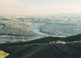
Clarkston is located at 46°24′49"N 117°2′55"W (46.413545, -117.048742). Immediately across the Snake River from Clarkston is the town of Lewiston, Idaho
.
According to the United States Census Bureau
, the city has a total area of 2.0 square miles (5.3 km²), of which, 1.9 square miles (5.0 km²) of it is land and 0.1 square miles (0.3 km²) of it (4.93%) is water.
, and 2.15% from two or more races. Hispanic or Latino of any race were 2.56% of the population.
There were 3,120 households out of which 29.9% had children under the age of 18 living with them, 37.1% were married couples living together, 15.7% had a female householder with no husband present, and 42.6% were non-families. 35.7% of all households were made up of individuals and 15.6% had someone living alone who was 65 years of age or older. The average household size was 2.26 and the average family size was 2.92.
In the city the age distribution of the population shows 25.7% under the age of 18, 9.7% from 18 to 24, 26.6% from 25 to 44, 20.0% from 45 to 64, and 18.0% who were 65 years of age or older. The median age was 36 years. For every 100 females there were 86.9 males. For every 100 females age 18 and over, there were 79.3 males.
The median income for a household in the city was $25,907, and the median income for a family was $32,093. Males had a median income of $31,434 versus $20,654 for females. The per capita income
for the city was $14,673. About 15.5% of families and 20.6% of the population were below the poverty line, including 27.6% of those under age 18 and 8.1% of those age 65 or over.
. Agriculture is a major industry in the area and the port handles a lot of barge traffic carrying grains. The paper company Clearwater Paper Corporation
transports wood chips and sawdust via barges for use at a Lewiston
manufacturing plant. Due to its inland location on the Snake River
, the port handles goods headed out to Portland-Vancouver
, and inland to distributors upstream.
The port's marina has accommodations for personal boats and yachts, many of which travel through the nearby Hells Canyon
.
Lewiston metropolitan area
The Lewiston Metropolitan Statistical Area, as defined by the United States Census Bureau, is an area consisting of two counties – one in the Idaho Panhandle and the other in eastern Washington, anchored by the city of Lewiston...
. The population was 7,229 in 2010.
In 1993, Walla Walla Community College
Walla Walla Community College
Walla Walla Community College is a multi-campus community college located in southeastern Washington.WWCC's main branch was established in Walla Walla in 1967 with a first class of 850 students and has grown to an average annual enrollment of over 13,000 students...
opened a Branch Campus in Clarkston that serves the surrounding area, Lewiston, Idaho. It is still a major draw for the surrounding area.
With a ZIP code
ZIP Code
ZIP codes are a system of postal codes used by the United States Postal Service since 1963. The term ZIP, an acronym for Zone Improvement Plan, is properly written in capital letters and was chosen to suggest that the mail travels more efficiently, and therefore more quickly, when senders use the...
of 99403, Clarkston has the highest zip code of any area in the contiguous United States
Contiguous United States
The contiguous United States are the 48 U.S. states on the continent of North America that are south of Canada and north of Mexico, plus the District of Columbia....
.
History
Clarkston was first settled in 1862 by Robert Bracken. It was officially incorporated on August 14, 1902. Before becoming an official town, the area was called Jawbone Flats. The name Clarkston is a reference to William Clark, of Lewis and Clark fame. LewistonLewiston, Idaho
Lewiston is a city in and also the county seat of Nez Perce County in the Pacific Northwest state of Idaho. It is the second-largest city in the northern Idaho region, behind Coeur d'Alene and ninth-largest in the state. Lewiston is the principal city of the Lewiston, ID - Clarkston, WA...
, across the Idaho state line from Clarkston, is named for Meriwether Lewis
Meriwether Lewis
Meriwether Lewis was an American explorer, soldier, and public administrator, best known for his role as the leader of the Lewis and Clark Expedition also known as the Corps of Discovery, with William Clark...
, and is the larger and older of the two cities (ironically Lewis and Clark never even set foot on the Clarkston side of the river).
Geography
Clarkston is in the Lewis-Clark Valley, at the confluence of the SnakeSnake River
The Snake is a major river of the greater Pacific Northwest in the United States. At long, it is the largest tributary of the Columbia River, the largest North American river that empties into the Pacific Ocean...
and Clearwater
Clearwater River (Idaho)
The Clearwater River is a river in north central Idaho, which flows westward from the Bitterroot Mountains along the Idaho-Montana border, and joins the Snake River at Lewiston. In October 1805, the Lewis and Clark Expedition descended the Clearwater River in dugout canoes, putting in at "Canoe...
rivers.
Clarkston is located at 46°24′49"N 117°2′55"W (46.413545, -117.048742). Immediately across the Snake River from Clarkston is the town of Lewiston, Idaho
Lewiston, Idaho
Lewiston is a city in and also the county seat of Nez Perce County in the Pacific Northwest state of Idaho. It is the second-largest city in the northern Idaho region, behind Coeur d'Alene and ninth-largest in the state. Lewiston is the principal city of the Lewiston, ID - Clarkston, WA...
.
According to the United States Census Bureau
United States Census Bureau
The United States Census Bureau is the government agency that is responsible for the United States Census. It also gathers other national demographic and economic data...
, the city has a total area of 2.0 square miles (5.3 km²), of which, 1.9 square miles (5.0 km²) of it is land and 0.1 square miles (0.3 km²) of it (4.93%) is water.
Demographics
As of the census of 2000, there were 7,337 people, 3,120 households, and 1,790 families residing in the city. The population density was 3,805.4 people per square mile (1,467.8/km²). There were 3,414 housing units at an average density of 1,770.7 per square mile (683.0/km²). The racial makeup of the city was 94.43% White, 0.34% African American, 1.61% Native American, 0.65% Asian, 0.03% Pacific Islander, 0.79% from other racesRace (United States Census)
Race and ethnicity in the United States Census, as defined by the Federal Office of Management and Budget and the United States Census Bureau, are self-identification data items in which residents choose the race or races with which they most closely identify, and indicate whether or not they are...
, and 2.15% from two or more races. Hispanic or Latino of any race were 2.56% of the population.
There were 3,120 households out of which 29.9% had children under the age of 18 living with them, 37.1% were married couples living together, 15.7% had a female householder with no husband present, and 42.6% were non-families. 35.7% of all households were made up of individuals and 15.6% had someone living alone who was 65 years of age or older. The average household size was 2.26 and the average family size was 2.92.
In the city the age distribution of the population shows 25.7% under the age of 18, 9.7% from 18 to 24, 26.6% from 25 to 44, 20.0% from 45 to 64, and 18.0% who were 65 years of age or older. The median age was 36 years. For every 100 females there were 86.9 males. For every 100 females age 18 and over, there were 79.3 males.
The median income for a household in the city was $25,907, and the median income for a family was $32,093. Males had a median income of $31,434 versus $20,654 for females. The per capita income
Per capita income
Per capita income or income per person is a measure of mean income within an economic aggregate, such as a country or city. It is calculated by taking a measure of all sources of income in the aggregate and dividing it by the total population...
for the city was $14,673. About 15.5% of families and 20.6% of the population were below the poverty line, including 27.6% of those under age 18 and 8.1% of those age 65 or over.
Port
The Port Of Clarkston is home to one of the largest cranes on a navigable waterway east of PortlandPortland, Oregon
Portland is a city located in the Pacific Northwest, near the confluence of the Willamette and Columbia rivers in the U.S. state of Oregon. As of the 2010 Census, it had a population of 583,776, making it the 29th most populous city in the United States...
. Agriculture is a major industry in the area and the port handles a lot of barge traffic carrying grains. The paper company Clearwater Paper Corporation
Clearwater Paper Corporation
Clearwater Paper Corporation is a pulp and paper product manufacturer that was created on December 9, 2008 via a spin-off from the real estate investment trust company Potlatch Corporation...
transports wood chips and sawdust via barges for use at a Lewiston
Lewiston, Idaho
Lewiston is a city in and also the county seat of Nez Perce County in the Pacific Northwest state of Idaho. It is the second-largest city in the northern Idaho region, behind Coeur d'Alene and ninth-largest in the state. Lewiston is the principal city of the Lewiston, ID - Clarkston, WA...
manufacturing plant. Due to its inland location on the Snake River
Snake River
The Snake is a major river of the greater Pacific Northwest in the United States. At long, it is the largest tributary of the Columbia River, the largest North American river that empties into the Pacific Ocean...
, the port handles goods headed out to Portland-Vancouver
Vancouver, Washington
Vancouver is a city on the north bank of the Columbia River in the U.S. state of Washington. Incorporated in 1857, it is the fourth largest city in the state with a 2010 census population of 161,791 as of April 1, 2010...
, and inland to distributors upstream.
The port's marina has accommodations for personal boats and yachts, many of which travel through the nearby Hells Canyon
Hells Canyon
Hells Canyon is a wide canyon located along the border of eastern Oregon and western Idaho in the United States. It is North America's deepest river gorge at and part of the Hells Canyon National Recreation Area....
.
External links
- City website
- History of Clarkston at HistoryLinkHistoryLinkHistoryLink is a website that is an encyclopedia of Washington State history. The site has more than 4,500 stories. There are 500 biographies and more than 14,000 images....