
Mount Rainier National Park
Encyclopedia
Mount Rainier National Park is a United States National Park located in southeast Pierce County
and northeast Lewis County
in Washington state. It was one of the US's earliest National Parks, having been established on March 2, 1899 as the fifth national park in the United States. The park contains 368 square miles (953.1 km²) including all of Mount Rainier
, a 14,411-foot (4,392 m) stratovolcano
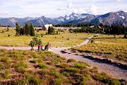
. The mountain rises abruptly from the surrounding land with elevations in the park ranging from 1,600 feet (490 m) to over 14,000 feet (4,300 m). The highest point in the Cascade Range
, around it are valleys, waterfalls, subalpine wildflower meadows, old growth forest and more than 26 glacier
s. The volcano is often shrouded in clouds that dump enormous amounts of rain and snow on the peak every year and hide it from the crowds that head to the park on weekends.
Mount Rainier
is circled by the Wonderland Trail
and is covered by several glaciers and snowfields totaling some 35 square miles (90.6 km²). Carbon Glacier
is the largest glacier by volume in the continental United States, while Emmons Glacier
is the largest glacier by area. About 1.3 million people visit Mount Rainier National Park each year. Mount Rainier is a popular peak for mountain climbing with some 10,000 attempts per year with approximately 25% making it to the summit.
The park contains outstanding subalpine
meadow
s and 91000 acres (368.3 km²) of old growth forest
s.
under the National Wilderness Preservation System
, including Clearwater Wilderness
and Mount Rainier Wilderness
, a designation it received in 1988. It is abutted by the Tatoosh Wilderness
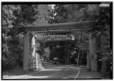
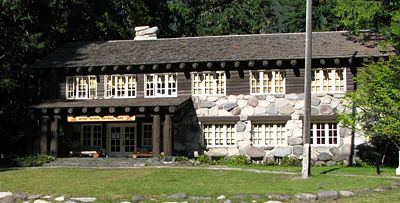
. The park was designated a National Historic Landmark
on 18 February 1997 as a showcase for the National Park Service Rustic
style architecture (or parkitecture) of the 1920s and 1930s, exemplified by the Paradise Inn
and a masterpiece of early NPS master planning. As an Historic Landmark district, the park was administratively listed on the National Register of Historic Places
.
) found along Bench Lake Trail (the first section of Snow Lake
Trail).
A more substantial archeological find was a rock shelter near Fryingpan Creek, east of Goat Island Mountain. Hunting artifacts were found in the shelter. The shelter would not have been used all year round. Cultural affinities suggest the site was used by Columbia Plateau Tribes
from 1000 to 300 BP.
In 1963 the National Park Service contracted the Washington State University
to study Native American
use of the Mount Rainier area. Richard D. Daugherty lead an archeological study of the area and concluded that prehistoric humans used the area most heavily between 8000 and 4500 BP. Allan H. Smith interviewed elderly Native Americans and studied ethnographic literature. He found no evidence of permanent habitation in the park area. The park was used for hunting and gathering
and for occasional spirit quests
. Smith also came to tentative conclusions that the park was divided among five tribes along watershed boundaries; the Nisqually
, Puyallup
, Muckleshoot
, Yakama
, and Taidnapam (Upper Cowlitz). Subsequent studies cast doubt on Smith's theory that the tribes had agreed upon boundaries before they entered into treaties with the United States in 1854-55.
signed a bill passed by Congress authorizing the creation of Mount Rainier National Park, the nation's fifth national park. It was the first national park created from a national forest
. The Pacific Forest Reserve
had been created in 1893 and included Mount Rainier. It was enlarged in 1897 and renamed Mount Rainier Forest Reserve
. John Muir
had visited Mount Rainier in 1888. Muir and nine others, including Edward Sturgis Ingraham
, Charles Piper
, and P. B. Van Trump
, climbed to the summit in what became the fifth recorded ascent. The trip to Mount Rainier had played a role in reinvigorating Muir and convincing him to rededicate his life to the preservation of nature as national parks. At the time national forests, called forest reserves at first, were being created throughout the American West, under the utilitarian "conservation-through-use" view of Gifford Pinchot
. Muir was what came to be known as a "preservationist". He wanted nature preserved under the more protected status of national parks. But during the 1890s there was more public support for creating national forests than national parks. During that decade, Muir and his supporters were only able to protect one national forest as a national park. When the Pacific Forest Reserve was created in 1893, Muir quickly persuaded the newly formed Sierra Club
to support a movement to protect Rainier as a national park. Other groups soon joined, such as the National Geographic Society
and scientific associations wanting Mount Rainier preserved as a place to study volcanism
and glaciology
. Commercial leaders in Tacoma
and Seattle were also in support, as was the Northern Pacific Railway
. The effort lasted over five years and involved six different attempts to push a bill through Congress. Congress eventually agreed, but only after acquiring assurances that none of the new park was suitable for farming or mining and that no federal appropriations would be necessary for its management.
rainstorm when 18 inches (457.2 mm) of rain fell in a 36 hour period. Campsites and roads throughout the park were washed away. Power to Paradise and Longmire was disrupted. On 5 May 2007, the park reopened to automobile traffic via State Route 706
at the Nisqually Entrance.
District on February 18, 1997, in recognition of the consistently high standard of design and preservation the park's National Park Service Rustic
-style architecture. The park contains 42 locations
designated on the National Register of Historic Places
, including four National Historic Landmarks.
(built 1916), Paradise Guide House (built 1920) and Henry M. Jackson Visitor Center
(built 1966;
demolished and replaced, 2008).
The National Park Service
says that "Paradise is the snowiest place on Earth where snowfall is measured regularly." 1,122 inches (93.5 ft, 28.5 m) of snow fell during the winter of 1971/72, setting a world record for that year Subsequently, in the winter of 1998/99, Mount Baker Ski Area received 1140 inches (95 ft, 29 m) Paradise holds the Cascade Range record for most snow on the ground with 367 inches (9.32 m) on 10 March 1956.
 Longmire (46.75°N 121.81°W) is a visitor center
in Mount Rainier National Park, located 6.5 miles (10.5 km) east of the Nisqually Entrance. The area is in the Nisqually River
valley at an elevation of 2761 feet (842 m) between The Ramparts Ridge and the Tatoosh Range
. Longmire is surrounded by old-growth Douglas fir, western red cedar and western hemlock
.
Longmire is the location of Mount Rainier's National Park Inn, the Longmire Museum, and the 1928 National Park Service Administration Building, which is now a Wilderness Information Center. The National Park Inn is the only accommodation in the park open all year round.
Longmire is the second most popular destination for visitors to Mount Rainier National Park after Paradise. Of the more than 1.3 million people who visited the park in 2000, 38% visited Longmire. The Cougar Rock Campground
is about 2 miles (3 km) north west of Longmire. Longmire is one of the starting points of the Wonderland Trail
.
 Sunrise (46.91°N 121.64°W) is a lodge and visitor center
located in the northeastern part of the park. At an elevation of 6,400 feet (1,950 m), it is the highest point in the park that is accessible by vehicle. There are miles of trails
located all around Sunrise, such as Mount Fremont and Sourdough Ridge. The lodge is reachable via a 10-mile (16 km) turnoff from SR 410
near the White River
entrance.
 Ohanapecosh (icon) is a campground, visitor center, and ranger
station located in the southeastern portion of the park, approximately 3 miles (4.8 km) from the park boundary off Highway 123
. Located in a deep valley among old growth forest at an elevation below 2000 feet (609.6 m), it is the only developed area of the park without a view of Mount Rainier. The Ohanapecosh Hot Springs, Grove of the Patriarchs, and Silver Falls are all located in the Ohanapecosh area.
The Carbon River Entrance Station is located in the northwest corner of the park off Highway 165
and is the site of the only rainforest
at Mount Rainier. There is a campground and a short trail through the rainforest, as well as a trail to the Carbon Glacier, one of the lowest glaciers in the contiguous United States.
Mowich Lake is the largest and deepest lake in the park, located south of Carbon at the south end of Highway 165. A campground, picnic area, and hiking trail are located near the lake.
The two major roads into the northwest quadrant of the Park were severely damaged by the floods of 2006. The ranger station at the Carbon River entrance is staffed during the summer. No motor vehicles are permitted beyond that point.
Pierce County, Washington
right|thumb|[[Tacoma, Washington|Tacoma]] - Seat of Pierce CountyPierce County is the second most populous county in the U.S. state of Washington. Formed out of Thurston County on December 22, 1852, by the legislature of Oregon Territory...
and northeast Lewis County
Lewis County, Washington
Lewis County is a county located in the U.S. state of Washington. As of 2010, the population was 75,455. The county seat is at Chehalis, and its largest city is Centralia....
in Washington state. It was one of the US's earliest National Parks, having been established on March 2, 1899 as the fifth national park in the United States. The park contains 368 square miles (953.1 km²) including all of Mount Rainier
Mount Rainier
Mount Rainier is a massive stratovolcano located southeast of Seattle in the state of Washington, United States. It is the most topographically prominent mountain in the contiguous United States and the Cascade Volcanic Arc, with a summit elevation of . Mt. Rainier is considered one of the most...
, a 14,411-foot (4,392 m) stratovolcano
Stratovolcano
A stratovolcano, also known as a composite volcano, is a tall, conical volcano built up by many layers of hardened lava, tephra, pumice, and volcanic ash. Unlike shield volcanoes, stratovolcanoes are characterized by a steep profile and periodic, explosive eruptions...
. The mountain rises abruptly from the surrounding land with elevations in the park ranging from 1,600 feet (490 m) to over 14,000 feet (4,300 m). The highest point in the Cascade Range
Cascade Range
The Cascade Range is a major mountain range of western North America, extending from southern British Columbia through Washington and Oregon to Northern California. It includes both non-volcanic mountains, such as the North Cascades, and the notable volcanoes known as the High Cascades...
, around it are valleys, waterfalls, subalpine wildflower meadows, old growth forest and more than 26 glacier
Glacier
A glacier is a large persistent body of ice that forms where the accumulation of snow exceeds its ablation over many years, often centuries. At least 0.1 km² in area and 50 m thick, but often much larger, a glacier slowly deforms and flows due to stresses induced by its weight...
s. The volcano is often shrouded in clouds that dump enormous amounts of rain and snow on the peak every year and hide it from the crowds that head to the park on weekends.
Mount Rainier
Mount Rainier
Mount Rainier is a massive stratovolcano located southeast of Seattle in the state of Washington, United States. It is the most topographically prominent mountain in the contiguous United States and the Cascade Volcanic Arc, with a summit elevation of . Mt. Rainier is considered one of the most...
is circled by the Wonderland Trail
Wonderland Trail
The Wonderland Trail is an approximately 93 mile hiking trail that circumnavigates Mount Rainier in Mount Rainier National Park, Washington, United States. The trail goes over many ridges of Mount Rainier for a cumulative of elevation gain. The trail was built in 1915...
and is covered by several glaciers and snowfields totaling some 35 square miles (90.6 km²). Carbon Glacier
Carbon Glacier
Carbon Glacier is an album by Laura Veirs, released in 2004. The song Rapture was heard during the episode "Save Me", from the first season of Grey's Anatomy.-Track listing:#"Ether Sings" – 3:44#"Icebound Stream" – 3:04#"Rapture" – 3:06...
is the largest glacier by volume in the continental United States, while Emmons Glacier
Emmons Glacier
Emmons Glacier is a glacier on the northeast flank of Mount Rainier, in Washington. At , it has the largest surface area of any glacier in the contiguous United States. The glacier was named after the geologist Samuel Franklin Emmons after his involvement in a survey of Mount Rainier in...
is the largest glacier by area. About 1.3 million people visit Mount Rainier National Park each year. Mount Rainier is a popular peak for mountain climbing with some 10,000 attempts per year with approximately 25% making it to the summit.
The park contains outstanding subalpine
Subalpine
The subalpine zone is the biotic zone immediately below tree line around the world. Species that occur in this zone depend on the location of the zone on the Earth, for example, Snow Gum in Australia, or Subalpine Larch, Mountain Hemlock and Subalpine Fir in western North America.Trees in the...
meadow
Meadow
A meadow is a field vegetated primarily by grass and other non-woody plants . The term is from Old English mædwe. In agriculture a meadow is grassland which is not grazed by domestic livestock but rather allowed to grow unchecked in order to make hay...
s and 91000 acres (368.3 km²) of old growth forest
Old growth forest
An old-growth forest is a forest that has attained great age , and thereby exhibits unique ecological features. An old growth forest has also usually reached a climax community...
s.
History
Ninety-seven percent of the park is preserved as wildernessWilderness
Wilderness or wildland is a natural environment on Earth that has not been significantly modified by human activity. It may also be defined as: "The most intact, undisturbed wild natural areas left on our planet—those last truly wild places that humans do not control and have not developed with...
under the National Wilderness Preservation System
National Wilderness Preservation System
The National Wilderness Preservation System of the United States protects federally managed land areas designated for preservation in their natural condition. It was established by the Wilderness Act upon the signature of President Lyndon B. Johnson on September 3, 1964...
, including Clearwater Wilderness
Clearwater Wilderness
Clearwater Wilderness, a small wilderness created by Congress in the 1984 under the 1964 Wilderness Act establishing the National Wilderness Preservation System. It is located in northeast Pierce County, southeast of Tacoma in the South Cascade Range in Washington, US...
and Mount Rainier Wilderness
Mount Rainier Wilderness
Mount Rainier Wilderness is a designated wilderness area located within Mount Rainier National Park in the Cascade Range of western Washington, United States.-External links:* - Mount Rainier National Park* - Wilderness.net...
, a designation it received in 1988. It is abutted by the Tatoosh Wilderness
Tatoosh Wilderness
The Tatoosh Wilderness, located in Washington, in the Pacific Northwest region of the United States, is managed by the U.S. Forest Service and protects . In 1984 it was officially designated as wilderness by Congress....
. The park was designated a National Historic Landmark
National Historic Landmark
A National Historic Landmark is a building, site, structure, object, or district, that is officially recognized by the United States government for its historical significance...
on 18 February 1997 as a showcase for the National Park Service Rustic
National Park Service Rustic
National Park Service rustic, also colloquially known as Parkitecture, is a style of architecture that arose in the United States National Park System to create buildings that harmonized with their natural environment. Since its founding, the National Park Service consistently has sought to provide...
style architecture (or parkitecture) of the 1920s and 1930s, exemplified by the Paradise Inn
Paradise Inn (Washington)
Paradise Inn is a historic hotel built in 1916 at 5,400 feet on the south slope of Mount Rainier in Mount Rainier National Park in Washington, United States. The inn is named after Paradise, the area on the mountain it is located. The Henry M. Jackson Visitor Center and the 1920 Paradise...
and a masterpiece of early NPS master planning. As an Historic Landmark district, the park was administratively listed on the National Register of Historic Places
National Register of Historic Places
The National Register of Historic Places is the United States government's official list of districts, sites, buildings, structures, and objects deemed worthy of preservation...
.
Native Americans
The earliest evidence of human activity in the area which is now Mount Rainier National Park is a projectile point dated to circa 4,000-5,800 BP (before presentBefore Present
Before Present years is a time scale used in archaeology, geology, and other scientific disciplines to specify when events in the past occurred. Because the "present" time changes, standard practice is to use AD 1950 as the origin of the age scale, reflecting the fact that radiocarbon...
) found along Bench Lake Trail (the first section of Snow Lake
Snow Lake (Mount Rainier)
Snow Lake is a lake in Lewis County, Washington. It is within Mount Rainier National Park. It is in a glacial cirque below Unicorn Peak, in the Tatoosh Range....
Trail).
A more substantial archeological find was a rock shelter near Fryingpan Creek, east of Goat Island Mountain. Hunting artifacts were found in the shelter. The shelter would not have been used all year round. Cultural affinities suggest the site was used by Columbia Plateau Tribes
Confederated Tribes of the Umatilla Indian Reservation
The Confederated Tribes of the Umatilla Indian Reservation is a federally recognized confederation of three Sahaptin-speaking Native American tribes who traditionally inhabited the Columbia River Plateau region: the Cayuse, Umatilla, and Walla Walla....
from 1000 to 300 BP.
In 1963 the National Park Service contracted the Washington State University
Washington State University
Washington State University is a public research university based in Pullman, Washington, in the Palouse region of the Pacific Northwest. Founded in 1890, WSU is the state's original and largest land-grant university...
to study Native American
Native Americans in the United States
Native Americans in the United States are the indigenous peoples in North America within the boundaries of the present-day continental United States, parts of Alaska, and the island state of Hawaii. They are composed of numerous, distinct tribes, states, and ethnic groups, many of which survive as...
use of the Mount Rainier area. Richard D. Daugherty lead an archeological study of the area and concluded that prehistoric humans used the area most heavily between 8000 and 4500 BP. Allan H. Smith interviewed elderly Native Americans and studied ethnographic literature. He found no evidence of permanent habitation in the park area. The park was used for hunting and gathering
Hunter-gatherer
A hunter-gatherer or forage society is one in which most or all food is obtained from wild plants and animals, in contrast to agricultural societies which rely mainly on domesticated species. Hunting and gathering was the ancestral subsistence mode of Homo, and all modern humans were...
and for occasional spirit quests
Vision quest
A vision quest is a rite of passage in some Native American cultures.In many Native American groups, the vision quest is a turning point in life taken before puberty to find oneself and the intended spiritual and life direction. When an older child is ready, he or she will go on a personal,...
. Smith also came to tentative conclusions that the park was divided among five tribes along watershed boundaries; the Nisqually
Nisqually (tribe)
Nisqually is a Lushootseed Native American tribe in western Washington state in the United States. The tribe lives on a reservation in the Nisqually River valley near the river delta. The Nisqually Indian Reservation, at , comprises 20.602 km² of land area on both sides of the river, in...
, Puyallup
Puyallup (tribe)
The Puyallup are a Coast Salish Native American tribe from western Washington state, U.S.A. They were forcibly relocated onto reservation lands in what is today Tacoma, Washington, in late 1854, after signing the Treaty of Medicine Creek. The Puyallup Indian Reservation today is one of the most...
, Muckleshoot
Muckleshoot
The Muckleshoot are a Lushootseed Native American tribe, part of the Coast Salish peoples of the Pacific Northwest whose traditional territory and reservations is located in the area of Auburn, Washington, between Seattle and Tacoma...
, Yakama
Yakama
The Confederated Tribes and Bands of the Yakama Nation, or simply Yakama Nation , is a Native American group with nearly 10,000 enrolled members, living in Washington. Their reservation, along the Yakima River, covers an area of approximately 1.2 million acres...
, and Taidnapam (Upper Cowlitz). Subsequent studies cast doubt on Smith's theory that the tribes had agreed upon boundaries before they entered into treaties with the United States in 1854-55.
Park creation
On March 2, 1899, President William McKinleyWilliam McKinley
William McKinley, Jr. was the 25th President of the United States . He is best known for winning fiercely fought elections, while supporting the gold standard and high tariffs; he succeeded in forging a Republican coalition that for the most part dominated national politics until the 1930s...
signed a bill passed by Congress authorizing the creation of Mount Rainier National Park, the nation's fifth national park. It was the first national park created from a national forest
United States National Forest
National Forest is a classification of federal lands in the United States.National Forests are largely forest and woodland areas owned by the federal government and managed by the United States Forest Service, part of the United States Department of Agriculture. Land management of these areas...
. The Pacific Forest Reserve
Pacific Forest Reserve
The Pacific Forest Reserve was established by the General Land Office in Washington on February 20, 1893 with . On February 22, 1898 the forest was combined with other lands to create the Mount Rainier Forest Reserve, and the name was discontinued....
had been created in 1893 and included Mount Rainier. It was enlarged in 1897 and renamed Mount Rainier Forest Reserve
Mount Rainier Forest Reserve
The Mount Rainier Forest Reserve in Washington was established by the General Land Office on February 22, 1898 from the Pacific Forest Reserve and other lands with . In 1905 federal forests were transferred to the U.S. Forest Service. On March 2, 1907 the name was changed to Rainier National Forest...
. John Muir
John Muir
John Muir was a Scottish-born American naturalist, author, and early advocate of preservation of wilderness in the United States. His letters, essays, and books telling of his adventures in nature, especially in the Sierra Nevada mountains of California, have been read by millions...
had visited Mount Rainier in 1888. Muir and nine others, including Edward Sturgis Ingraham
Edward Sturgis Ingraham
Edward Sturgis Ingraham was the first superintendent of the Seattle Public Schools, a noted mountaineer who climbed Mount Rainier 13 times, and a leader in the effort to establish Mount Rainier National Park. Seattle's Ingraham High School is named in his honor, as is the Ingraham Glacier on...
, Charles Piper
Charles Piper
Charles Vancouver Piper was an American botanist and agriculturalist. Born in Victoria, British Columbia, Canada, he spent his youth in Seattle, Washington Territory and graduated from the University of Washington Territory in 1885. He taught botany and zoology in 1892 at the Washington...
, and P. B. Van Trump
P. B. Van Trump
Philemon Beecher Van Trump , also known as P. B. Van Trump, was an American pioneering mountaineer and writer who lived in the state of Washington. He is best known for the first ascent of Mount Rainier in 1870....
, climbed to the summit in what became the fifth recorded ascent. The trip to Mount Rainier had played a role in reinvigorating Muir and convincing him to rededicate his life to the preservation of nature as national parks. At the time national forests, called forest reserves at first, were being created throughout the American West, under the utilitarian "conservation-through-use" view of Gifford Pinchot
Gifford Pinchot
Gifford Pinchot was the first Chief of the United States Forest Service and the 28th Governor of Pennsylvania...
. Muir was what came to be known as a "preservationist". He wanted nature preserved under the more protected status of national parks. But during the 1890s there was more public support for creating national forests than national parks. During that decade, Muir and his supporters were only able to protect one national forest as a national park. When the Pacific Forest Reserve was created in 1893, Muir quickly persuaded the newly formed Sierra Club
Sierra Club
The Sierra Club is the oldest, largest, and most influential grassroots environmental organization in the United States. It was founded on May 28, 1892, in San Francisco, California, by the conservationist and preservationist John Muir, who became its first president...
to support a movement to protect Rainier as a national park. Other groups soon joined, such as the National Geographic Society
National Geographic Society
The National Geographic Society , headquartered in Washington, D.C. in the United States, is one of the largest non-profit scientific and educational institutions in the world. Its interests include geography, archaeology and natural science, the promotion of environmental and historical...
and scientific associations wanting Mount Rainier preserved as a place to study volcanism
Volcanism
Volcanism is the phenomenon connected with volcanoes and volcanic activity. It includes all phenomena resulting from and causing magma within the crust or mantle of a planet to rise through the crust and form volcanic rocks on the surface....
and glaciology
Glaciology
Glaciology Glaciology Glaciology (from Middle French dialect (Franco-Provençal): glace, "ice"; or Latin: glacies, "frost, ice"; and Greek: λόγος, logos, "speech" lit...
. Commercial leaders in Tacoma
Tacoma, Washington
Tacoma is a mid-sized urban port city and the county seat of Pierce County, Washington, United States. The city is on Washington's Puget Sound, southwest of Seattle, northeast of the state capital, Olympia, and northwest of Mount Rainier National Park. The population was 198,397, according to...
and Seattle were also in support, as was the Northern Pacific Railway
Northern Pacific Railway
The Northern Pacific Railway was a railway that operated in the west along the Canadian border of the United States. Construction began in 1870 and the main line opened all the way from the Great Lakes to the Pacific when former president Ulysses S. Grant drove in the final "golden spike" in...
. The effort lasted over five years and involved six different attempts to push a bill through Congress. Congress eventually agreed, but only after acquiring assurances that none of the new park was suitable for farming or mining and that no federal appropriations would be necessary for its management.
2006 flooding
Mount Rainier National Park closed because of extensive flooding as a result of the 6 November 2006 Pineapple ExpressPineapple Express
Pineapple Express is a non-technical term for a meteorological phenomenon characterized by a strong and persistent flow of atmospheric moisture and associated heavy rainfall from the waters adjacent to the Hawaiian Islands and extending to any location along the Pacific coast of North America...
rainstorm when 18 inches (457.2 mm) of rain fell in a 36 hour period. Campsites and roads throughout the park were washed away. Power to Paradise and Longmire was disrupted. On 5 May 2007, the park reopened to automobile traffic via State Route 706
Washington State Route 706
State Route 706 is a state highway in Pierce County, in the U.S. state of Washington. It extends from SR 7 in the census-designated place of Elbe east to the Longmire gate of Mount Rainier National Park.The highway formerly was part of the Tacoma – Mount Rainier branch of Primary...
at the Nisqually Entrance.
Major attractions
The entire park was designated a National Historic LandmarkNational Historic Landmark
A National Historic Landmark is a building, site, structure, object, or district, that is officially recognized by the United States government for its historical significance...
District on February 18, 1997, in recognition of the consistently high standard of design and preservation the park's National Park Service Rustic
National Park Service Rustic
National Park Service rustic, also colloquially known as Parkitecture, is a style of architecture that arose in the United States National Park System to create buildings that harmonized with their natural environment. Since its founding, the National Park Service consistently has sought to provide...
-style architecture. The park contains 42 locations
National Register of Historic Places listings in Mount Rainier National Park
This is a list of the National Register of Historic Places listings in Mount Rainier National Park.This is intended to be a complete list of the properties and districts on the National Register of Historic Places in Mount Rainier National Park, Washington, United States...
designated on the National Register of Historic Places
National Register of Historic Places
The National Register of Historic Places is the United States government's official list of districts, sites, buildings, structures, and objects deemed worthy of preservation...
, including four National Historic Landmarks.
Paradise
Paradise (46.79°N 121.74°W) is the name of an area at approximately 5400 feet (1,645.9 m) on the south slope of Mount Rainier in the national park. Paradise is the most popular destination for visitors to Mount Rainier National Park. 62% of the over 1.3 million people who visited the park in 2000 went to Paradise. Paradise is the location of the historic Paradise InnParadise Inn (Washington)
Paradise Inn is a historic hotel built in 1916 at 5,400 feet on the south slope of Mount Rainier in Mount Rainier National Park in Washington, United States. The inn is named after Paradise, the area on the mountain it is located. The Henry M. Jackson Visitor Center and the 1920 Paradise...
(built 1916), Paradise Guide House (built 1920) and Henry M. Jackson Visitor Center
Henry M. Jackson Visitor Center
The Henry M. Jackson Visitor Center is a day-use facility located in the Paradise area of Mount Rainier National Park. The facility offers exhibits, films, guided ranger programs, a book store, a snack bar, and a gift shop, as well as public restrooms, and informational brochures and maps.The first...
(built 1966;
demolished and replaced, 2008).
The National Park Service
National Park Service
The National Park Service is the U.S. federal agency that manages all national parks, many national monuments, and other conservation and historical properties with various title designations...
says that "Paradise is the snowiest place on Earth where snowfall is measured regularly." 1,122 inches (93.5 ft, 28.5 m) of snow fell during the winter of 1971/72, setting a world record for that year Subsequently, in the winter of 1998/99, Mount Baker Ski Area received 1140 inches (95 ft, 29 m) Paradise holds the Cascade Range record for most snow on the ground with 367 inches (9.32 m) on 10 March 1956.
Longmire
Visitor center
A visitor center or centre , visitor information center, tourist information center, is a physical location that provides tourist information to the visitors who tour the place or area locally...
in Mount Rainier National Park, located 6.5 miles (10.5 km) east of the Nisqually Entrance. The area is in the Nisqually River
Nisqually River
The Nisqually River is a river in west central Washington in the United States, approximately long. It drains part of the Cascade Range southwest of Tacoma, including the southern slope of Mount Rainier, and empties into the southern end of Puget Sound....
valley at an elevation of 2761 feet (842 m) between The Ramparts Ridge and the Tatoosh Range
Tatoosh Range
The Tatoosh Range is a mountain range located in Mount Rainier National Park and the adjacent Tatoosh Wilderness in the state of Washington, in the Pacific Northwest region of the United States. The range runs roughly east–west, beginning with the southeastern Tatoosh Peak and concluding with the...
. Longmire is surrounded by old-growth Douglas fir, western red cedar and western hemlock
Western Hemlock
Tsuga heterophylla. the Western Hemlock, is a species of hemlock native to the west coast of North America, with its northwestern limit on the Kenai Peninsula, Alaska, and its southeastern limit in northern Sonoma County, California.-Habitat:...
.
Longmire is the location of Mount Rainier's National Park Inn, the Longmire Museum, and the 1928 National Park Service Administration Building, which is now a Wilderness Information Center. The National Park Inn is the only accommodation in the park open all year round.
Longmire is the second most popular destination for visitors to Mount Rainier National Park after Paradise. Of the more than 1.3 million people who visited the park in 2000, 38% visited Longmire. The Cougar Rock Campground
Campsite
A campsite or camping pitch is a place used for overnight stay in the outdoors. In British English a campsite is an area, usually divided into a number of pitches, where people can camp overnight using tents or camper vans or caravans; this British English use of the word is synonymous with the...
is about 2 miles (3 km) north west of Longmire. Longmire is one of the starting points of the Wonderland Trail
Wonderland Trail
The Wonderland Trail is an approximately 93 mile hiking trail that circumnavigates Mount Rainier in Mount Rainier National Park, Washington, United States. The trail goes over many ridges of Mount Rainier for a cumulative of elevation gain. The trail was built in 1915...
.
Sunrise
Visitor center
A visitor center or centre , visitor information center, tourist information center, is a physical location that provides tourist information to the visitors who tour the place or area locally...
located in the northeastern part of the park. At an elevation of 6,400 feet (1,950 m), it is the highest point in the park that is accessible by vehicle. There are miles of trails
Wonderland Trail
The Wonderland Trail is an approximately 93 mile hiking trail that circumnavigates Mount Rainier in Mount Rainier National Park, Washington, United States. The trail goes over many ridges of Mount Rainier for a cumulative of elevation gain. The trail was built in 1915...
located all around Sunrise, such as Mount Fremont and Sourdough Ridge. The lodge is reachable via a 10-mile (16 km) turnoff from SR 410
Washington State Route 410
State Route 410 is a long state highway that traverses Pierce, King, and Yakima counties in the U.S. state of Washington. It begins at an interchange with SR 167 in Sumner and travels southeast across the Cascade Range to a junction with U.S. Route 12 in Naches...
near the White River
White River (Washington)
The White River is a white, glacial river in the U.S. state of Washington. It flows about 75 miles from its source, the Emmons Glacier on Mount Rainier, to join the Puyallup River at Sumner...
entrance.
Other developed areas
National Park Ranger
National Park Service Rangers are among the uniformed employees charged with protecting and preserving areas set aside in the National Park System by the United States Congress and/or the President of the United States...
station located in the southeastern portion of the park, approximately 3 miles (4.8 km) from the park boundary off Highway 123
Washington State Route 123
State Route 123 is a state highway in the Gifford Pinchot National Forest and Mount Rainier National Park east of Mount Rainier in the U.S. state of Washington. Located in the counties of Lewis and Pierce, the long roadway extends through a heavily forested canyon from to...
. Located in a deep valley among old growth forest at an elevation below 2000 feet (609.6 m), it is the only developed area of the park without a view of Mount Rainier. The Ohanapecosh Hot Springs, Grove of the Patriarchs, and Silver Falls are all located in the Ohanapecosh area.
The Carbon River Entrance Station is located in the northwest corner of the park off Highway 165
Washington State Route 165
State Route 165 is a numbered state highway in Washington, United States. Its northern terminus is at State Route 410 in Buckley. Its southern terminus is at the Mount Rainier National Park boundary near Mowich Lake.-Route description:...
and is the site of the only rainforest
Rainforest
Rainforests are forests characterized by high rainfall, with definitions based on a minimum normal annual rainfall of 1750-2000 mm...
at Mount Rainier. There is a campground and a short trail through the rainforest, as well as a trail to the Carbon Glacier, one of the lowest glaciers in the contiguous United States.
Mowich Lake is the largest and deepest lake in the park, located south of Carbon at the south end of Highway 165. A campground, picnic area, and hiking trail are located near the lake.
The two major roads into the northwest quadrant of the Park were severely damaged by the floods of 2006. The ranger station at the Carbon River entrance is staffed during the summer. No motor vehicles are permitted beyond that point.
External links
- National Park Service site: Mount Rainier National Park
- Park map (PDF, 2 MB), provided by the National Park ServiceNational Park ServiceThe National Park Service is the U.S. federal agency that manages all national parks, many national monuments, and other conservation and historical properties with various title designations...
- National Historic Landmark information
- University of Washington Libraries Digital Collections – Rainier National Park Mountain-Glacier Wonderland Photograph Album 50 photographs from a promotional album (ca. 1925) for Mount Rainier National Park depicting tourist facilities, scenic views of the mountain and surrounding parkland, and recreational activities including mountaineering.
- Electronic Documents outlining the natural and cultural history of the park, including the complete Nature Notes (newsletter) series and the park's Administrative History [National Park Service]