

Washington State Route 410
Encyclopedia
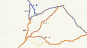
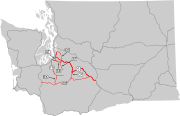
State Route 410 is a 107.44 miles (172.91 km) long state highway
that traverses Pierce
, King
, and Yakima
counties in the U.S. state
of Washington. It begins at an interchange with SR 167 in Sumner
and travels southeast across the Cascade Range
to a junction with U.S. Route 12
(US 12) in Naches
. While the western part of SR 410 is a freeway that serves built-up, urban areas, the remainder of the route is a surface road that traverses mostly rural areas as it passes through the mountains.
The route starts as a limited-access southerly bypass
of Downtown Sumner, but becomes a surface road east of the city. Traveling eastward, the roadway serves Bonney Lake
and Buckley
, and crosses and eventually parallels the White River
into Enumclaw
and Greenwater
. SR 410 enters the Mount Baker-Snoqualmie National Forest
and later heads into Mount Rainier National Park
, crossing the Cayuse
and Chinook
passes, and leaves the park southeast along the American River
into Wenatchee National Forest
. SR 410 leaves the national forest and travels parallel to the Naches River
to end in Naches, a city located west of Yakima
. The Chinook Scenic Byway begins in Enumclaw and follows the highway through the two national forests and Mount Rainier National Park to US 12 in Naches.
Modern SR 410 was parts of various state wagon roads until 1926 when US 410
was established, extending from Aberdeen
to Lewiston
, Idaho
. US 410 was decommissioned after US 12 was extended over the majority of the highway in 1967, bypassing Olympia
and Chinook Pass
. A segment of former US 410 from Elma
to Olympia became SR 8 and the Tacoma
to Naches segment became SR 410. The highway was later shortened to end in Sumner and was replaced by SR 167 from Tacoma to Sumner.
. The highway travels southeast across suburban areas, crossing the Stuck River
and passing a partial cloverleaf interchange with Linden Drive, also named Traffic Avenue. After a second partial cloverleaf interchange with Thompson Avenue, SR 410 goes under a railroad trestle owned by BNSF Railway
and used by Amtrak
's Cascades
rail service, near the northern bank
of the Puyallup River
. After turning northeast, SR 410 encounters the western terminus of SR 162
by way of a diamond interchange
. SR 162 travels north into Downtown Sumner as Valley Avenue and south over the Puyallup River towards Orting
. The freeway section near the interchange was the busiest recorded part of SR 410 in 2008 with a daily average of 59,000 motorists using the freeway. Continuing northeast, SR 410 connects to 166th Avenue and turns southeast as an undivided highway into the community of Bonney Lake
. East of Bonney Lake, the roadway heads east, passing two shopping centers before entering Buckley
and intersecting SR 165
. In Buckley, the street travels northeast through Downtown and turns north to cross the White River
and enter King County
.
After leaving Pierce County
, the highway travels northeast through rural areas into Enumclaw
and passes Enumclaw High School
before turning east and being renamed Roosevelt Avenue. As Roosevelt Avenue, the street intersects Griffin Avenue, also designated SR 164
, which travels northwest to SR 169
and Auburn
. The roadway, now named the Chinook Scenic Byway, passes by the King County Fairgrounds and Enumclaw King County Park. Leaving Enumclaw in a southeastern direction, SR 410 begins to parallel the White River upriver into Federation Forest State Park
, a 619 acre (2.5 km²; 0.967188355161986 sq mi) state park consisting of old growth evergreen
forests. The highway crosses the Greenwater River
, northeast of its confluence
with the White River, and re-enters Pierce County.
 The bridge ends in the community of Greenwater
, named for the river, where the roadway encounters Forest Road 70, which has been proposed to become SR 168
over Naches Pass
as an alternative to the Chinook Scenic Byway. From Greenwater, the road travels south alongside the White River into Mount Baker-Snoqualmie National Forest
, passing Ranger Creek State Airport, a state-owned airport that is open in the summer and early fall. The byway travels south into Mount Rainier National Park
and intersects SR 123
at Cayuse Pass
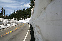
. SR 410 turns east at the intersection and heads through a series of hairpin turn
s, passing Tipsoo Lake
, to Chinook Pass
.
Chinook Pass is the border between Pierce and Yakima
counties and Mount Rainier National Park and the Wenatchee National Forest
. The pass is also where the highway crosses the Pacific Crest Trail
, a National Scenic Trail
that was completed in 1993. East of Chinook Pass, the roadway begins to parallel the American River
northeast to follow the Little Naches River, which becomes the Naches River
. After a junction with the other end of the proposed SR 168, named Little Naches Road, the highway exits the Wenatchee National Forest and enters Naches
. The byway ends at US 12
in Naches near the Naches Selah Canal.
 The first portion of SR 410 that was defined under law to be built by the state of Washington was a state wagon road that extended from a county road in King County
to a county road near Naches
. The road ran up alongside the White River
until it reached the summit of the Cascades and continued traveling down parallel to the American River
before ending at the county road connecting to Naches. This road was approved and built in 1897, making it one of the oldest state roads in Washington state. In 1905, the road became known as State Road 1 and was incorporated into the first state highway system. By 1907, the road was named the White River – Natches Road and was shortened to end at Cedar Springs. The rest of the road was transferred to State Road 5, called the Cowlitz–Natches Road, which ran from Napavine
to Naches.
In 1913, the state highway system was adjusted again, and several new roads were added to the system, including parts of what would become US 410
. The Olympic Highway traveled around the Olympic Peninsula
and a section from Aberdeen
to Olympia
was later used as part of US 410. The Pacific Highway would later have a brief concurrency
with US 410 from Olympia to Tacoma
, and US 410 would later connect to the National Park Highway in Tacoma and follow it to Burkley, where State Road 5, now a secondary highway maintained by the counties, began. From the end of State Road 5 in Naches, the Inland Empire Highway is concurrent with the future US 410 to Dayton
, where a branch of the highway travels to Clarkston
. State Road 5 became the McClellan Pass Highway in 1919 and was aligned further south to Chinook Pass
. The McClellan Pass Highway was renamed the Naches Pass Highway in 1921 to reflect the realignment in 1919.
 In 1923, the state highway system was restructured completely, incorporating numbers instead of names. The Olympic Highway became State Road 9, the Pacific Highway became State Road 1, the National Park Highway absorbed the Naches Pass Highway and remained State Road 5, and the Inland Empire Highway became State Road 3, but its branch from Dayton to Clarkston remained a branch of the now non-existent Inland Empire Highway. A system of national highways that improved on the concept of auto trail
s was formed in late 1925. The final plan for the system—which became the U.S. routes
—was approved on November 11, 1926. One of the routes included in the plan was US 410, which extended from US 101
in Aberdeen
to US 95
in Lewiston
, Idaho
. Parts of US 410 were concurrent with other new highways, including US 99
from Olympia to Tacoma and US 97
in Yakima. In 1937, the state highway system changed to a primary and secondary system. US 410 remained the same, but its concurrent state highways had their designations changed by the state. State Road 9 became Primary State Highway 9 (PSH 9), State Road 1 and US 99 became PSH 1, State Road 5 became PSH 5, State Road 3 became PSH 3, and the Inland Empire Highway branch from Dayton to Clarkston became a branch of PSH 3.
In 1964, Washington unveiled a new numbering system for highways. Concurrencies with state primary state highways would be repealed in 1970 and US 410 would be a non-concurrent highway. On June 20, 1967, US 12
was extended west from Lewiston, Idaho, over White Pass
to Aberdeen, eliminating most of the original route of the highway. The remaining sections were split amongst other routes. The segment from Elma
to Olympia became State Route 8 (SR 8). Interstate 5
(I-5) took the Olympia–Tacoma segment, and the Tacoma–Naches segment became SR 410. The last reassurance marker
s for US 410 were taken down by December 1967.
Originally, SR 410 passed through downtown Puyallup and Sumner, following several surface streets (including Main Avenue in Puyallup and Traffic Avenue and Main Street in Sumner) across the two cities. In the late 1960s, construction began on a limited-access bypass of the two city centers. SR 410 was moved onto the new freeway by 1972. In 1973, SR 410 was shortened to its current length after SR 167 was extended to Tacoma. On October 11, 2009, a massive landslide buried about 0.25 mile (0.402335 km) of SR 410 west of Naches in the Nile Valley. The landslide also blocked off the Naches River
and caused warnings of severe flooding. A detour
was set up on Nile Road that was for residential use only until October 20. SR 410 was permanently rerouted onto Nile Road sometime afterward, and the Washington State Department of Transportation
(WSDOT) completed paving on the new segment of SR 410 on November 20.
|-
! scope="col" | County
! scope="col" | Location
! scope="col" | Mile
! scope="col" | Destinations
! scope="col" | Notes
|-
|rowspan=7|Pierce
|rowspan=5|Sumner
|0.00
|
|
|-
|0.48
|Linden Drive (Traffic Avenue) / Thompson Avenue
|
|-
|1.56
|
|Western terminus of SR 162
|-
|2.63
|166th Avenue East / Sumner Tapps Highway East
|
|-
| style="text-align:center" colspan=3|East end of freeway
|-
|Buckley
|11.84
|
|Northern terminus of SR 165
|-
| style="text-align:center" colspan=4 rowspan=2|Bridge over White River
|-
|rowspan=4|King
|-
|rowspan=2|Enumclaw
|rowspan=2|15.98
|
|
|-
| style="text-align:center" colspan=2|Begin Chinook Scenic Byway
|-
|
|rowspan=2|33.87
| style="text-align:center" colspan=2 rowspan=2|Bridge over Greenwater River
|-
|rowspan=5|Pierce
|rowspan=2|Greenwater
|-
|35.96
| – Naches Pass
|Proposed SR 168
east
|-
|
|48.70
|Mount Rainier National Park
gate (entrance)
|
|-
|Cayuse Pass
|56.86
|
|Northern terminus of SR 123
|-
|rowspan=2|Chinook Pass
|rowspan=2|60.32
| style="text-align:center" colspan=2 rowspan=2|Chinook Pass
|-
|rowspan=4|Yakima
|-
|rowspan=2|Wenatchee NF
|65.64
|Mount Rainier National Park
gate (entrance)
|
|-
|83.20
|Little Naches Road – Naches Pass
|Proposed SR 168
west
|-
|Naches
|107.44
|
|
State highways in Washington
In the U.S. state of Washington, the Washington State Department of Transportation maintains a network of over 7000 miles of state highways, including all Interstate and U.S. Highways that pass through the state. The system comprises 8.5% of the state's public road mileage, but carries over half...
that traverses Pierce
Pierce County, Washington
right|thumb|[[Tacoma, Washington|Tacoma]] - Seat of Pierce CountyPierce County is the second most populous county in the U.S. state of Washington. Formed out of Thurston County on December 22, 1852, by the legislature of Oregon Territory...
, King
King County, Washington
King County is a county located in the U.S. state of Washington. The population in the 2010 census was 1,931,249. King is the most populous county in Washington, and the 14th most populous in the United States....
, and Yakima
Yakima County, Washington
Yakima County is the second largest county by area in the U.S. state of Washington. It is named after the Yakama tribe of Native Americans. In the 2010 census, its population was 243,231...
counties in the U.S. state
U.S. state
A U.S. state is any one of the 50 federated states of the United States of America that share sovereignty with the federal government. Because of this shared sovereignty, an American is a citizen both of the federal entity and of his or her state of domicile. Four states use the official title of...
of Washington. It begins at an interchange with SR 167 in Sumner
Sumner, Washington
Sumner is a city in northern Pierce County, Washington, United States. The population was 9,451 at the 2010 census. Nearby cities include Puyallup to the west, Auburn to the north, and Enumclaw to the east.-History:...
and travels southeast across the Cascade Range
Cascade Range
The Cascade Range is a major mountain range of western North America, extending from southern British Columbia through Washington and Oregon to Northern California. It includes both non-volcanic mountains, such as the North Cascades, and the notable volcanoes known as the High Cascades...
to a junction with U.S. Route 12
U.S. Route 12 in Washington
U.S. Route 12 is a major east-west U.S. Highway, running from Aberdeen, Washington, to Detroit, Michigan. It spans across the state of Washington, and is the only numbered highway to span the entire state from west to east, starting near the Pacific Ocean, and crossing the Idaho state line near...
(US 12) in Naches
Naches, Washington
Naches is a town in Yakima County, Washington, United States. The population was 795 individuals at the 2010 census.-Infrastructure:Naches' infrastructure is based mainly on timber and agriculture, known for its large masses of apple, cherries, pears and various other fruits.-Geography:Naches is...
. While the western part of SR 410 is a freeway that serves built-up, urban areas, the remainder of the route is a surface road that traverses mostly rural areas as it passes through the mountains.
The route starts as a limited-access southerly bypass
Bypass (road)
A bypass is a road or highway that avoids or "bypasses" a built-up area, town, or village, to let through traffic flow without interference from local traffic, to reduce congestion in the built-up area, and to improve road safety....
of Downtown Sumner, but becomes a surface road east of the city. Traveling eastward, the roadway serves Bonney Lake
Bonney Lake, Washington
Bonney Lake is a city in Pierce County, Washington, United States. The population was 17,374 at the 2010 census.-Geography:Bonney Lake is located at ....
and Buckley
Buckley, Washington
Buckley is a city in Pierce County, Washington, United States. The population was 4,354 at the 2010 census.-Geography:Buckley is located at near the communities of Enumclaw, Bonney Lake, and Wilkeson....
, and crosses and eventually parallels the White River
White River (Washington)
The White River is a white, glacial river in the U.S. state of Washington. It flows about 75 miles from its source, the Emmons Glacier on Mount Rainier, to join the Puyallup River at Sumner...
into Enumclaw
Enumclaw, Washington
Enumclaw is a city in King County, Washington, United States. The population was 10,669 at the 2010 census.The Enumclaw Plateau, on which the city resides, was formed by a volcanic mudflow from Mount Rainier approximately 5,700 years ago....
and Greenwater
Greenwater, Washington
Greenwater is a census-designated place in Pierce County, Washington, United States. The population was 67 at the 2010 census.Based on per capita income, Greenwater ranks 17th of 522 areas in the state of Washington to be ranked...
. SR 410 enters the Mount Baker-Snoqualmie National Forest
Mount Baker-Snoqualmie National Forest
The Mount Baker-Snoqualmie National Forest in Washington extends more than along the western slopes of the Cascade Range from the Canadian border to the northern boundary of Mount Rainier National Park. Forest headquarters are located in the city of Everett....
and later heads into Mount Rainier National Park
Mount Rainier National Park
Mount Rainier National Park is a United States National Park located in southeast Pierce County and northeast Lewis County in Washington state. It was one of the US's earliest National Parks, having been established on March 2, 1899 as the fifth national park in the United States. The park contains...
, crossing the Cayuse
Cayuse Pass
Cayuse Pass is a mountain pass in the Cascade Mountains in the state of Washington.The pass is about 32 miles southeast of Enumclaw on State Route 410. The intersection with State Route 123 is at the pass....
and Chinook
Chinook Pass
Chinook Pass is a pass through the Cascade Range in the state of Washington.The pass provides the east entrance to Mount Rainier National Park, and carries State Route 410 between the towns of Enumclaw and Naches. Because of the high elevation, Chinook Pass is usually closed in November due to...
passes, and leaves the park southeast along the American River
American River (Washington)
The American River is a tributary of the Bumping River, in Washington in the United States. It flows down the east side of the Cascade Range, through Wenatchee National Forest and the William O...
into Wenatchee National Forest
Wenatchee National Forest
Wenatchee National Forest is a U.S. National Forest located in Washington. With an area of 1,735,394 acres , it extends about 137 miles along the eastern slopes of the Cascade Range of Washington, USA from Okanogan National Forest to Gifford Pinchot National Forest...
. SR 410 leaves the national forest and travels parallel to the Naches River
Naches River
The Naches River is a tributary of the Yakima River in central Washington in the United States. Beginning as the Little Naches River, it is about 75 miles long. After the confluence of the Little Naches and Bumping River the name becomes simply the Naches River...
to end in Naches, a city located west of Yakima
Yakima, Washington
Yakima is an American city southeast of Mount Rainier National Park and the county seat of Yakima County, Washington, United States, and the eighth largest city by population in the state itself. As of the 2010 census, the city had a total population of 91,196 and a metropolitan population of...
. The Chinook Scenic Byway begins in Enumclaw and follows the highway through the two national forests and Mount Rainier National Park to US 12 in Naches.
Modern SR 410 was parts of various state wagon roads until 1926 when US 410
U.S. Route 410
U.S. Route 410 was one of the west–east state highways. It ran from an intersection with US 101 in Aberdeen, Washington to US 95 in Lewiston, Idaho. The route had concurrencies with SR 8, US 99, and US 395. Even though the number indicates that US 410 was a spur of U.S. Route 10, US 410 never...
was established, extending from Aberdeen
Aberdeen, Washington
Aberdeen is a city in Grays Harbor County, Washington, United States, founded by Samuel Benn in 1884. Aberdeen was incorporated on May 12, 1890. The city is the economic center of Grays Harbor County, bordering the cities of Hoquiam and Cosmopolis...
to Lewiston
Lewiston, Idaho
Lewiston is a city in and also the county seat of Nez Perce County in the Pacific Northwest state of Idaho. It is the second-largest city in the northern Idaho region, behind Coeur d'Alene and ninth-largest in the state. Lewiston is the principal city of the Lewiston, ID - Clarkston, WA...
, Idaho
Idaho
Idaho is a state in the Rocky Mountain area of the United States. The state's largest city and capital is Boise. Residents are called "Idahoans". Idaho was admitted to the Union on July 3, 1890, as the 43rd state....
. US 410 was decommissioned after US 12 was extended over the majority of the highway in 1967, bypassing Olympia
Olympia, Washington
Olympia is the capital city of the U.S. state of Washington and the county seat of Thurston County. It was incorporated on January 28, 1859. The population was 46,478 at the 2010 census...
and Chinook Pass
Chinook Pass
Chinook Pass is a pass through the Cascade Range in the state of Washington.The pass provides the east entrance to Mount Rainier National Park, and carries State Route 410 between the towns of Enumclaw and Naches. Because of the high elevation, Chinook Pass is usually closed in November due to...
. A segment of former US 410 from Elma
Elma, Washington
Elma is a city in Grays Harbor County, Washington, United States. The population was 3,107 at the 2010 census.-Geography:Elma is located at ....
to Olympia became SR 8 and the Tacoma
Tacoma, Washington
Tacoma is a mid-sized urban port city and the county seat of Pierce County, Washington, United States. The city is on Washington's Puget Sound, southwest of Seattle, northeast of the state capital, Olympia, and northwest of Mount Rainier National Park. The population was 198,397, according to...
to Naches segment became SR 410. The highway was later shortened to end in Sumner and was replaced by SR 167 from Tacoma to Sumner.
Route description
SR 410 begins as a freeway at an interchange with SR 167 near Downtown SumnerSumner, Washington
Sumner is a city in northern Pierce County, Washington, United States. The population was 9,451 at the 2010 census. Nearby cities include Puyallup to the west, Auburn to the north, and Enumclaw to the east.-History:...
. The highway travels southeast across suburban areas, crossing the Stuck River
Stuck River (Washington)
The Stuck River in Washington state is a former small stream turned distributary and later final course of the White River, near Auburn to the Puyallup River at Sumner...
and passing a partial cloverleaf interchange with Linden Drive, also named Traffic Avenue. After a second partial cloverleaf interchange with Thompson Avenue, SR 410 goes under a railroad trestle owned by BNSF Railway
BNSF Railway
The BNSF Railway is a wholly owned subsidiary of Berkshire Hathaway Inc., and is headquartered in Fort Worth, Texas. It is one of seven North American Class I railroads and the second largest freight railroad network in North America, second only to the Union Pacific Railroad, its primary...
and used by Amtrak
Amtrak
The National Railroad Passenger Corporation, doing business as Amtrak , is a government-owned corporation that was organized on May 1, 1971, to provide intercity passenger train service in the United States. "Amtrak" is a portmanteau of the words "America" and "track". It is headquartered at Union...
's Cascades
Amtrak Cascades
The Amtrak Cascades is a passenger train route operated by Amtrak in partnership with the states of Washington and Oregon in the Pacific Northwest of the United States and the province of British Columbia in Canada...
rail service, near the northern bank
Bank (geography)
A geographic bank has four definitions and applications:# Limnology: The shoreline of a pond, swamp, estuary, reservoir, or lake. The grade can vary from vertical to a shallow slope....
of the Puyallup River
Puyallup River
The Puyallup River is a river in the U.S. state of Washington. About long, it is formed by glaciers on the west side of Mount Rainier. It flows generally northwest, emptying into Commencement Bay, part of Puget Sound...
. After turning northeast, SR 410 encounters the western terminus of SR 162
Washington State Route 162
State Route 162 is a long state highway located entirely in Pierce County, Washington, United States.- Route description :...
by way of a diamond interchange
Diamond interchange
A diamond interchange is a common type of road junction, used where a freeway crosses a minor road. The freeway itself is grade-separated from the minor road, one crossing the other over a bridge...
. SR 162 travels north into Downtown Sumner as Valley Avenue and south over the Puyallup River towards Orting
Orting, Washington
Orting is a city in Pierce County, Washington, United States. The population as of the 2010 census is 6,746, according to the City of Orting.- History :...
. The freeway section near the interchange was the busiest recorded part of SR 410 in 2008 with a daily average of 59,000 motorists using the freeway. Continuing northeast, SR 410 connects to 166th Avenue and turns southeast as an undivided highway into the community of Bonney Lake
Bonney Lake, Washington
Bonney Lake is a city in Pierce County, Washington, United States. The population was 17,374 at the 2010 census.-Geography:Bonney Lake is located at ....
. East of Bonney Lake, the roadway heads east, passing two shopping centers before entering Buckley
Buckley, Washington
Buckley is a city in Pierce County, Washington, United States. The population was 4,354 at the 2010 census.-Geography:Buckley is located at near the communities of Enumclaw, Bonney Lake, and Wilkeson....
and intersecting SR 165
Washington State Route 165
State Route 165 is a numbered state highway in Washington, United States. Its northern terminus is at State Route 410 in Buckley. Its southern terminus is at the Mount Rainier National Park boundary near Mowich Lake.-Route description:...
. In Buckley, the street travels northeast through Downtown and turns north to cross the White River
White River (Washington)
The White River is a white, glacial river in the U.S. state of Washington. It flows about 75 miles from its source, the Emmons Glacier on Mount Rainier, to join the Puyallup River at Sumner...
and enter King County
King County, Washington
King County is a county located in the U.S. state of Washington. The population in the 2010 census was 1,931,249. King is the most populous county in Washington, and the 14th most populous in the United States....
.
After leaving Pierce County
Pierce County, Washington
right|thumb|[[Tacoma, Washington|Tacoma]] - Seat of Pierce CountyPierce County is the second most populous county in the U.S. state of Washington. Formed out of Thurston County on December 22, 1852, by the legislature of Oregon Territory...
, the highway travels northeast through rural areas into Enumclaw
Enumclaw, Washington
Enumclaw is a city in King County, Washington, United States. The population was 10,669 at the 2010 census.The Enumclaw Plateau, on which the city resides, was formed by a volcanic mudflow from Mount Rainier approximately 5,700 years ago....
and passes Enumclaw High School
Enumclaw High School
Enumclaw High School is a public secondary school in Enumclaw, Washington. The school serves about 1700 students from Enumclaw as well as local unincorporated regions of King County and cities such as Black Diamond and Greenwater.- Athletics :...
before turning east and being renamed Roosevelt Avenue. As Roosevelt Avenue, the street intersects Griffin Avenue, also designated SR 164
Washington State Route 164
State Route 164 is a long state highway located entirely with in King County, Washington, United States. The highway travels from SR 18 in Auburn to SR 410 in Enumclaw.- Route description :...
, which travels northwest to SR 169
Washington State Route 169
State Route 169 is a state highway in the U.S. state of Washington, running from SR 900 and I-405 in Renton through Maple Valley and Black Diamond to SR 164 in Enumclaw.- Route description :...
and Auburn
Auburn, Washington
-Parks:Auburn has an extensive system of parks, open space and urban trails comprising 29 developed parks, 5 undeveloped sites under planning, 2 skate parks, 2 water roatary parks, and over of trails , and almost of open space for passive and active recreation.-Environmental Park:The Auburn...
. The roadway, now named the Chinook Scenic Byway, passes by the King County Fairgrounds and Enumclaw King County Park. Leaving Enumclaw in a southeastern direction, SR 410 begins to parallel the White River upriver into Federation Forest State Park
Federation Forest State Park
Federation Forest State Park in King County, Washington is one of the Washington State Parks. It is a day-use park of of old-growth evergreen trees along the White River. Available activities include of hiking trail, an interpretive center with gift shop, birdwatching, wildlife viewing, and...
, a 619 acre (2.5 km²; 0.967188355161986 sq mi) state park consisting of old growth evergreen
Evergreen
In botany, an evergreen plant is a plant that has leaves in all seasons. This contrasts with deciduous plants, which completely lose their foliage during the winter or dry season.There are many different kinds of evergreen plants, both trees and shrubs...
forests. The highway crosses the Greenwater River
Greenwater River
The Greenwater River is a river in the U.S. state of Washington. Its watershed drains a portion of the Cascade Range east and northeast of Mount Rainier, including parts of the Norse Peak Wilderness. It flows into the White River at Greenwater, which eventually flows into Puget Sound via the...
, northeast of its confluence
Confluence
Confluence, in geography, describes the meeting of two or more bodies of water.Confluence may also refer to:* Confluence , a property of term rewriting systems...
with the White River, and re-enters Pierce County.
Greenwater, Washington
Greenwater is a census-designated place in Pierce County, Washington, United States. The population was 67 at the 2010 census.Based on per capita income, Greenwater ranks 17th of 522 areas in the state of Washington to be ranked...
, named for the river, where the roadway encounters Forest Road 70, which has been proposed to become SR 168
Washington State Route 168
State Route 168 is a legislated, but not constructed, state highway located in Washington, United States. The highway is meant to serve as an alternate crossing through the Cascade Range, supplementing the seasonal Chinook Pass on SR 410...
over Naches Pass
Naches Pass
Naches Pass is a mountain pass of the Cascade Range in the U.S. state of Washington. It is located about east of Tacoma and about northwest of Yakima, near the headwaters of tributary streams of the Naches River on the east and the Greenwater River on the west. The boundaries of Pierce, King,...
as an alternative to the Chinook Scenic Byway. From Greenwater, the road travels south alongside the White River into Mount Baker-Snoqualmie National Forest
Mount Baker-Snoqualmie National Forest
The Mount Baker-Snoqualmie National Forest in Washington extends more than along the western slopes of the Cascade Range from the Canadian border to the northern boundary of Mount Rainier National Park. Forest headquarters are located in the city of Everett....
, passing Ranger Creek State Airport, a state-owned airport that is open in the summer and early fall. The byway travels south into Mount Rainier National Park
Mount Rainier National Park
Mount Rainier National Park is a United States National Park located in southeast Pierce County and northeast Lewis County in Washington state. It was one of the US's earliest National Parks, having been established on March 2, 1899 as the fifth national park in the United States. The park contains...
and intersects SR 123
Washington State Route 123
State Route 123 is a state highway in the Gifford Pinchot National Forest and Mount Rainier National Park east of Mount Rainier in the U.S. state of Washington. Located in the counties of Lewis and Pierce, the long roadway extends through a heavily forested canyon from to...
at Cayuse Pass
Cayuse Pass
Cayuse Pass is a mountain pass in the Cascade Mountains in the state of Washington.The pass is about 32 miles southeast of Enumclaw on State Route 410. The intersection with State Route 123 is at the pass....
. SR 410 turns east at the intersection and heads through a series of hairpin turn
Hairpin turn
A hairpin turn , named for its resemblance to a hairpin/bobby pin, is a bend in a road with a very acute inner angle, making it necessary for an oncoming vehicle to turn almost 180° to continue on the road. Such turns in ramps and trails may be called switchbacks in American English, by analogy...
s, passing Tipsoo Lake
Tipsoo Lake
Tipsoo Lake, at an elevation of 5299 ft above sea level, is an alpine lake within the Northern Cascade Range located near the summit of Chinook Pass in Pierce County, Washington....
, to Chinook Pass
Chinook Pass
Chinook Pass is a pass through the Cascade Range in the state of Washington.The pass provides the east entrance to Mount Rainier National Park, and carries State Route 410 between the towns of Enumclaw and Naches. Because of the high elevation, Chinook Pass is usually closed in November due to...
.
Chinook Pass is the border between Pierce and Yakima
Yakima County, Washington
Yakima County is the second largest county by area in the U.S. state of Washington. It is named after the Yakama tribe of Native Americans. In the 2010 census, its population was 243,231...
counties and Mount Rainier National Park and the Wenatchee National Forest
Wenatchee National Forest
Wenatchee National Forest is a U.S. National Forest located in Washington. With an area of 1,735,394 acres , it extends about 137 miles along the eastern slopes of the Cascade Range of Washington, USA from Okanogan National Forest to Gifford Pinchot National Forest...
. The pass is also where the highway crosses the Pacific Crest Trail
Pacific Crest Trail
The Pacific Crest Trail is a long-distance mountain hiking and equestrian trail on the Western Seaboard of the United States. The southern terminus is at the California border with Mexico...
, a National Scenic Trail
National Scenic Trail
National Scenic Trail is a designation for protected areas in the United States that consist of trails of particular natural beauty.National Scenic Trails were authorized under the National Trails System Act of 1968 along with National Historic Trails and National Recreation Trails...
that was completed in 1993. East of Chinook Pass, the roadway begins to parallel the American River
American River (Washington)
The American River is a tributary of the Bumping River, in Washington in the United States. It flows down the east side of the Cascade Range, through Wenatchee National Forest and the William O...
northeast to follow the Little Naches River, which becomes the Naches River
Naches River
The Naches River is a tributary of the Yakima River in central Washington in the United States. Beginning as the Little Naches River, it is about 75 miles long. After the confluence of the Little Naches and Bumping River the name becomes simply the Naches River...
. After a junction with the other end of the proposed SR 168, named Little Naches Road, the highway exits the Wenatchee National Forest and enters Naches
Naches, Washington
Naches is a town in Yakima County, Washington, United States. The population was 795 individuals at the 2010 census.-Infrastructure:Naches' infrastructure is based mainly on timber and agriculture, known for its large masses of apple, cherries, pears and various other fruits.-Geography:Naches is...
. The byway ends at US 12
U.S. Route 12 in Washington
U.S. Route 12 is a major east-west U.S. Highway, running from Aberdeen, Washington, to Detroit, Michigan. It spans across the state of Washington, and is the only numbered highway to span the entire state from west to east, starting near the Pacific Ocean, and crossing the Idaho state line near...
in Naches near the Naches Selah Canal.
History
King County, Washington
King County is a county located in the U.S. state of Washington. The population in the 2010 census was 1,931,249. King is the most populous county in Washington, and the 14th most populous in the United States....
to a county road near Naches
Naches, Washington
Naches is a town in Yakima County, Washington, United States. The population was 795 individuals at the 2010 census.-Infrastructure:Naches' infrastructure is based mainly on timber and agriculture, known for its large masses of apple, cherries, pears and various other fruits.-Geography:Naches is...
. The road ran up alongside the White River
White River (Washington)
The White River is a white, glacial river in the U.S. state of Washington. It flows about 75 miles from its source, the Emmons Glacier on Mount Rainier, to join the Puyallup River at Sumner...
until it reached the summit of the Cascades and continued traveling down parallel to the American River
American River (Washington)
The American River is a tributary of the Bumping River, in Washington in the United States. It flows down the east side of the Cascade Range, through Wenatchee National Forest and the William O...
before ending at the county road connecting to Naches. This road was approved and built in 1897, making it one of the oldest state roads in Washington state. In 1905, the road became known as State Road 1 and was incorporated into the first state highway system. By 1907, the road was named the White River – Natches Road and was shortened to end at Cedar Springs. The rest of the road was transferred to State Road 5, called the Cowlitz–Natches Road, which ran from Napavine
Napavine, Washington
Napavine is a city in Lewis County, Washington, United States. The population was 1,766 at the 2010 census.-History:Napavine was officially incorporated as a town on November 21, 1913. Settlers began arriving in the Cowlitz area in the early 1850s...
to Naches.
In 1913, the state highway system was adjusted again, and several new roads were added to the system, including parts of what would become US 410
U.S. Route 410
U.S. Route 410 was one of the west–east state highways. It ran from an intersection with US 101 in Aberdeen, Washington to US 95 in Lewiston, Idaho. The route had concurrencies with SR 8, US 99, and US 395. Even though the number indicates that US 410 was a spur of U.S. Route 10, US 410 never...
. The Olympic Highway traveled around the Olympic Peninsula
Olympic Peninsula
The Olympic Peninsula is the large arm of land in western Washington state of the USA, that lies across Puget Sound from Seattle. It is bounded on the west by the Pacific Ocean, the north by the Strait of Juan de Fuca, and the east by Puget Sound. Cape Alava, the westernmost point in the contiguous...
and a section from Aberdeen
Aberdeen, Washington
Aberdeen is a city in Grays Harbor County, Washington, United States, founded by Samuel Benn in 1884. Aberdeen was incorporated on May 12, 1890. The city is the economic center of Grays Harbor County, bordering the cities of Hoquiam and Cosmopolis...
to Olympia
Olympia, Washington
Olympia is the capital city of the U.S. state of Washington and the county seat of Thurston County. It was incorporated on January 28, 1859. The population was 46,478 at the 2010 census...
was later used as part of US 410. The Pacific Highway would later have a brief concurrency
Concurrency (road)
A concurrency, overlap, or coincidence in a road network is an instance of one physical road bearing two or more different highway, motorway, or other route numbers...
with US 410 from Olympia to Tacoma
Tacoma, Washington
Tacoma is a mid-sized urban port city and the county seat of Pierce County, Washington, United States. The city is on Washington's Puget Sound, southwest of Seattle, northeast of the state capital, Olympia, and northwest of Mount Rainier National Park. The population was 198,397, according to...
, and US 410 would later connect to the National Park Highway in Tacoma and follow it to Burkley, where State Road 5, now a secondary highway maintained by the counties, began. From the end of State Road 5 in Naches, the Inland Empire Highway is concurrent with the future US 410 to Dayton
Dayton, Washington
Dayton is a city in and the county seat of Columbia County, Washington, United States. The population was 2,526 at the 2010 census.-History:...
, where a branch of the highway travels to Clarkston
Clarkston, Washington
Clarkston is a city in Asotin County in the southeastern part of the U.S. state of Washington. It is part of the Lewiston ID-WA Metropolitan Statistical Area. The population was 7,229 in 2010....
. State Road 5 became the McClellan Pass Highway in 1919 and was aligned further south to Chinook Pass
Chinook Pass
Chinook Pass is a pass through the Cascade Range in the state of Washington.The pass provides the east entrance to Mount Rainier National Park, and carries State Route 410 between the towns of Enumclaw and Naches. Because of the high elevation, Chinook Pass is usually closed in November due to...
. The McClellan Pass Highway was renamed the Naches Pass Highway in 1921 to reflect the realignment in 1919.
Auto trail
The system of auto trails was an informal network of marked routes that existed in the United States and Canada in the early part of the 20th century. Marked with colored bands on telephone poles, the trails were intended to help travellers in the early days of the automobile.Auto trails were...
s was formed in late 1925. The final plan for the system—which became the U.S. routes
United States Numbered Highways
The system of United States Numbered Highways is an integrated system of roads and highways in the United States numbered within a nationwide grid...
—was approved on November 11, 1926. One of the routes included in the plan was US 410, which extended from US 101
U.S. Route 101 in Washington
In the U.S. state of Washington, U.S. Route 101 is the westernmost state highway, serving the Olympic Peninsula. It runs from the Astoria-Megler Bridge north to the cities of Raymond, Aberdeen, Hoquiam, and Forks before turning east at the small community of Beaver to the most northern point of the...
in Aberdeen
Aberdeen, Washington
Aberdeen is a city in Grays Harbor County, Washington, United States, founded by Samuel Benn in 1884. Aberdeen was incorporated on May 12, 1890. The city is the economic center of Grays Harbor County, bordering the cities of Hoquiam and Cosmopolis...
to US 95
U.S. Route 95 in Idaho
In the U.S. state of Idaho, U.S. Route 95 is a north–south highway near the western border of the state, stretching from Oregon to British Columbia for over .-Route description:...
in Lewiston
Lewiston, Idaho
Lewiston is a city in and also the county seat of Nez Perce County in the Pacific Northwest state of Idaho. It is the second-largest city in the northern Idaho region, behind Coeur d'Alene and ninth-largest in the state. Lewiston is the principal city of the Lewiston, ID - Clarkston, WA...
, Idaho
Idaho
Idaho is a state in the Rocky Mountain area of the United States. The state's largest city and capital is Boise. Residents are called "Idahoans". Idaho was admitted to the Union on July 3, 1890, as the 43rd state....
. Parts of US 410 were concurrent with other new highways, including US 99
U.S. Route 99
U.S. Route 99 was the main north–south highway on the West Coast of the United States until 1964, running from Calexico, California, on the U.S.-Mexico border to Blaine, Washington, on the U.S.-Canada border. It was a route of the United States Numbered Highways, assigned in 1926 and existing...
from Olympia to Tacoma and US 97
U.S. Route 97 in Washington
In the U.S. state of Washington, U.S. Route 97 is a route which traverses from the Oregon state line at the northern end of the Sam Hill Memorial Bridge in Maryhill, north to the Canadian border in Okanogan County near Oroville...
in Yakima. In 1937, the state highway system changed to a primary and secondary system. US 410 remained the same, but its concurrent state highways had their designations changed by the state. State Road 9 became Primary State Highway 9 (PSH 9), State Road 1 and US 99 became PSH 1, State Road 5 became PSH 5, State Road 3 became PSH 3, and the Inland Empire Highway branch from Dayton to Clarkston became a branch of PSH 3.
In 1964, Washington unveiled a new numbering system for highways. Concurrencies with state primary state highways would be repealed in 1970 and US 410 would be a non-concurrent highway. On June 20, 1967, US 12
U.S. Route 12 in Washington
U.S. Route 12 is a major east-west U.S. Highway, running from Aberdeen, Washington, to Detroit, Michigan. It spans across the state of Washington, and is the only numbered highway to span the entire state from west to east, starting near the Pacific Ocean, and crossing the Idaho state line near...
was extended west from Lewiston, Idaho, over White Pass
White Pass (Washington)
White Pass is a mountain pass in the Cascade Range south of Mount Rainier and north of Goat Rocks in Washington, USA. U.S. Highway 12 passes over White Pass, connecting Yakima County with Lewis County....
to Aberdeen, eliminating most of the original route of the highway. The remaining sections were split amongst other routes. The segment from Elma
Elma, Washington
Elma is a city in Grays Harbor County, Washington, United States. The population was 3,107 at the 2010 census.-Geography:Elma is located at ....
to Olympia became State Route 8 (SR 8). Interstate 5
Interstate 5 in Washington
Interstate 5 in Washington is a highway in the U.S. state of Washington that extends from its border with Oregon to its border with Canada...
(I-5) took the Olympia–Tacoma segment, and the Tacoma–Naches segment became SR 410. The last reassurance marker
Reassurance marker
A reassurance marker or road identification sign is a road sign that repeats the name or number of the current route. Typically posted at intervals alongside a numbered highway, the signs are intended to reassure drivers that they are traveling on the desired road .- North America :In the United...
s for US 410 were taken down by December 1967.
Originally, SR 410 passed through downtown Puyallup and Sumner, following several surface streets (including Main Avenue in Puyallup and Traffic Avenue and Main Street in Sumner) across the two cities. In the late 1960s, construction began on a limited-access bypass of the two city centers. SR 410 was moved onto the new freeway by 1972. In 1973, SR 410 was shortened to its current length after SR 167 was extended to Tacoma. On October 11, 2009, a massive landslide buried about 0.25 mile (0.402335 km) of SR 410 west of Naches in the Nile Valley. The landslide also blocked off the Naches River
Naches River
The Naches River is a tributary of the Yakima River in central Washington in the United States. Beginning as the Little Naches River, it is about 75 miles long. After the confluence of the Little Naches and Bumping River the name becomes simply the Naches River...
and caused warnings of severe flooding. A detour
Detour (road)
A detour or diversion route is a route around a planned area of prohibited or reduced access, such as a construction site.Standard operating procedure for many road departments is to route any detour over roads within the same jurisdiction as the road with the obstructed area.On multi-lane highways...
was set up on Nile Road that was for residential use only until October 20. SR 410 was permanently rerouted onto Nile Road sometime afterward, and the Washington State Department of Transportation
Washington State Department of Transportation
The Washington State Department of Transportation , was established in 1905. The agency, led by a Secretary and overseen by the Governor, is a Washington governmental agency that constructs, maintains, and regulates the use of the state's transportation infrastructure...
(WSDOT) completed paving on the new segment of SR 410 on November 20.
Major intersections
{| class=wikitable|-
! scope="col" | County
! scope="col" | Location
! scope="col" | Mile
! scope="col" | Destinations
! scope="col" | Notes
|-
|rowspan=7|Pierce
Pierce County, Washington
right|thumb|[[Tacoma, Washington|Tacoma]] - Seat of Pierce CountyPierce County is the second most populous county in the U.S. state of Washington. Formed out of Thurston County on December 22, 1852, by the legislature of Oregon Territory...
|rowspan=5|Sumner
Sumner, Washington
Sumner is a city in northern Pierce County, Washington, United States. The population was 9,451 at the 2010 census. Nearby cities include Puyallup to the west, Auburn to the north, and Enumclaw to the east.-History:...
|0.00
|
|
|-
|0.48
|Linden Drive (Traffic Avenue) / Thompson Avenue
|
|-
|1.56
|
|Western terminus of SR 162
|-
|2.63
|166th Avenue East / Sumner Tapps Highway East
|
|-
| style="text-align:center" colspan=3|East end of freeway
|-
|Buckley
Buckley, Washington
Buckley is a city in Pierce County, Washington, United States. The population was 4,354 at the 2010 census.-Geography:Buckley is located at near the communities of Enumclaw, Bonney Lake, and Wilkeson....
|11.84
|
|Northern terminus of SR 165
|-
| style="text-align:center" colspan=4 rowspan=2|Bridge over White River
White River (Washington)
The White River is a white, glacial river in the U.S. state of Washington. It flows about 75 miles from its source, the Emmons Glacier on Mount Rainier, to join the Puyallup River at Sumner...
|-
|rowspan=4|King
King County, Washington
King County is a county located in the U.S. state of Washington. The population in the 2010 census was 1,931,249. King is the most populous county in Washington, and the 14th most populous in the United States....
|-
|rowspan=2|Enumclaw
Enumclaw, Washington
Enumclaw is a city in King County, Washington, United States. The population was 10,669 at the 2010 census.The Enumclaw Plateau, on which the city resides, was formed by a volcanic mudflow from Mount Rainier approximately 5,700 years ago....
|rowspan=2|15.98
|
|
|-
| style="text-align:center" colspan=2|Begin Chinook Scenic Byway
|-
|
|rowspan=2|33.87
| style="text-align:center" colspan=2 rowspan=2|Bridge over Greenwater River
Greenwater River
The Greenwater River is a river in the U.S. state of Washington. Its watershed drains a portion of the Cascade Range east and northeast of Mount Rainier, including parts of the Norse Peak Wilderness. It flows into the White River at Greenwater, which eventually flows into Puget Sound via the...
|-
|rowspan=5|Pierce
Pierce County, Washington
right|thumb|[[Tacoma, Washington|Tacoma]] - Seat of Pierce CountyPierce County is the second most populous county in the U.S. state of Washington. Formed out of Thurston County on December 22, 1852, by the legislature of Oregon Territory...
|rowspan=2|Greenwater
Greenwater, Washington
Greenwater is a census-designated place in Pierce County, Washington, United States. The population was 67 at the 2010 census.Based on per capita income, Greenwater ranks 17th of 522 areas in the state of Washington to be ranked...
|-
|35.96
| – Naches Pass
Naches Pass
Naches Pass is a mountain pass of the Cascade Range in the U.S. state of Washington. It is located about east of Tacoma and about northwest of Yakima, near the headwaters of tributary streams of the Naches River on the east and the Greenwater River on the west. The boundaries of Pierce, King,...
|Proposed SR 168
Washington State Route 168
State Route 168 is a legislated, but not constructed, state highway located in Washington, United States. The highway is meant to serve as an alternate crossing through the Cascade Range, supplementing the seasonal Chinook Pass on SR 410...
east
|-
|
|48.70
|Mount Rainier National Park
Mount Rainier National Park
Mount Rainier National Park is a United States National Park located in southeast Pierce County and northeast Lewis County in Washington state. It was one of the US's earliest National Parks, having been established on March 2, 1899 as the fifth national park in the United States. The park contains...
gate (entrance)
|
|-
|Cayuse Pass
Cayuse Pass
Cayuse Pass is a mountain pass in the Cascade Mountains in the state of Washington.The pass is about 32 miles southeast of Enumclaw on State Route 410. The intersection with State Route 123 is at the pass....
|56.86
|
|Northern terminus of SR 123
|-
|rowspan=2|Chinook Pass
Chinook Pass
Chinook Pass is a pass through the Cascade Range in the state of Washington.The pass provides the east entrance to Mount Rainier National Park, and carries State Route 410 between the towns of Enumclaw and Naches. Because of the high elevation, Chinook Pass is usually closed in November due to...
|rowspan=2|60.32
| style="text-align:center" colspan=2 rowspan=2|Chinook Pass
Chinook Pass
Chinook Pass is a pass through the Cascade Range in the state of Washington.The pass provides the east entrance to Mount Rainier National Park, and carries State Route 410 between the towns of Enumclaw and Naches. Because of the high elevation, Chinook Pass is usually closed in November due to...
|-
|rowspan=4|Yakima
Yakima County, Washington
Yakima County is the second largest county by area in the U.S. state of Washington. It is named after the Yakama tribe of Native Americans. In the 2010 census, its population was 243,231...
|-
|rowspan=2|Wenatchee NF
Wenatchee National Forest
Wenatchee National Forest is a U.S. National Forest located in Washington. With an area of 1,735,394 acres , it extends about 137 miles along the eastern slopes of the Cascade Range of Washington, USA from Okanogan National Forest to Gifford Pinchot National Forest...
|65.64
|Mount Rainier National Park
Mount Rainier National Park
Mount Rainier National Park is a United States National Park located in southeast Pierce County and northeast Lewis County in Washington state. It was one of the US's earliest National Parks, having been established on March 2, 1899 as the fifth national park in the United States. The park contains...
gate (entrance)
|
|-
|83.20
|Little Naches Road – Naches Pass
Naches Pass
Naches Pass is a mountain pass of the Cascade Range in the U.S. state of Washington. It is located about east of Tacoma and about northwest of Yakima, near the headwaters of tributary streams of the Naches River on the east and the Greenwater River on the west. The boundaries of Pierce, King,...
|Proposed SR 168
Washington State Route 168
State Route 168 is a legislated, but not constructed, state highway located in Washington, United States. The highway is meant to serve as an alternate crossing through the Cascade Range, supplementing the seasonal Chinook Pass on SR 410...
west
|-
|Naches
Naches, Washington
Naches is a town in Yakima County, Washington, United States. The population was 795 individuals at the 2010 census.-Infrastructure:Naches' infrastructure is based mainly on timber and agriculture, known for its large masses of apple, cherries, pears and various other fruits.-Geography:Naches is...
|107.44
|
|