
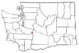
Chinook Pass
Encyclopedia
Mountain pass
A mountain pass is a route through a mountain range or over a ridge. If following the lowest possible route, a pass is locally the highest point on that route...
through the Cascade Range
Cascade Range
The Cascade Range is a major mountain range of western North America, extending from southern British Columbia through Washington and Oregon to Northern California. It includes both non-volcanic mountains, such as the North Cascades, and the notable volcanoes known as the High Cascades...
in the state of Washington.
The pass provides the east entrance to Mount Rainier National Park
Mount Rainier National Park
Mount Rainier National Park is a United States National Park located in southeast Pierce County and northeast Lewis County in Washington state. It was one of the US's earliest National Parks, having been established on March 2, 1899 as the fifth national park in the United States. The park contains...
, and carries State Route 410
Washington State Route 410
State Route 410 is a long state highway that traverses Pierce, King, and Yakima counties in the U.S. state of Washington. It begins at an interchange with SR 167 in Sumner and travels southeast across the Cascade Range to a junction with U.S. Route 12 in Naches...
between the towns of Enumclaw
Enumclaw, Washington
Enumclaw is a city in King County, Washington, United States. The population was 10,669 at the 2010 census.The Enumclaw Plateau, on which the city resides, was formed by a volcanic mudflow from Mount Rainier approximately 5,700 years ago....
and Naches
Naches, Washington
Naches is a town in Yakima County, Washington, United States. The population was 795 individuals at the 2010 census.-Infrastructure:Naches' infrastructure is based mainly on timber and agriculture, known for its large masses of apple, cherries, pears and various other fruits.-Geography:Naches is...
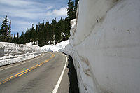
. Because of the high elevation, Chinook Pass is usually closed in November due to very heavy snow and significant avalanche
Avalanche
An avalanche is a sudden rapid flow of snow down a slope, occurring when either natural triggers or human activity causes a critical escalating transition from the slow equilibrium evolution of the snow pack. Typically occurring in mountainous terrain, an avalanche can mix air and water with the...
danger. It usually opens in mid May and is not uncommon to have a snow depth at the summit of up to 15-feet.
As part of the All-American Road program, Route 410 through Chinook Pass has been designated by the U.S. government as the Chinook Scenic Byway. It is considered to be one of the most beautiful routes in the United States. Because the summit is above the treeline, there are many places to park along the road to view the scenery. As commercial vehicles are not allowed through the National Park section of State Route 410, this route is also favored by summer tourism.
History
Chinook Pass was chosen as a route across the Cascade Mountains as a compromise. The height of the route would mean that it would likely never be a year-round road. The alternative was Naches PassNaches Pass
Naches Pass is a mountain pass of the Cascade Range in the U.S. state of Washington. It is located about east of Tacoma and about northwest of Yakima, near the headwaters of tributary streams of the Naches River on the east and the Greenwater River on the west. The boundaries of Pierce, King,...
, which with the addition of a short tunnel would be much lower (and easier to keep open in winter). The Naches Pass plan is still on the books as SR 168
Washington State Route 168
State Route 168 is a legislated, but not constructed, state highway located in Washington, United States. The highway is meant to serve as an alternate crossing through the Cascade Range, supplementing the seasonal Chinook Pass on SR 410...
, but it has never been built.
The cost of the tunnel was the deciding factor, and the Chinook Pass route was chosen.
The Yakima
Yakima, Washington
Yakima is an American city southeast of Mount Rainier National Park and the county seat of Yakima County, Washington, United States, and the eighth largest city by population in the state itself. As of the 2010 census, the city had a total population of 91,196 and a metropolitan population of...
side of a road over Chinook Pass was partially completed in 1914, but then work was abandoned for several years. This section was referred to as the 'Normile Grade'. In 1921 work began again on the Yakima side, below Normile, on the American River
American River (Washington)
The American River is a tributary of the Bumping River, in Washington in the United States. It flows down the east side of the Cascade Range, through Wenatchee National Forest and the William O...
. This work was done using horse teams. In 1924, an army tractor was brought in to speed up the work. Work on the west side of the road commenced later, and took longer. The two sides did not meet until 1931 at Tipsoo Lake
Tipsoo Lake
Tipsoo Lake, at an elevation of 5299 ft above sea level, is an alpine lake within the Northern Cascade Range located near the summit of Chinook Pass in Pierce County, Washington....
near the summit.
Recreation
From 1940–59, Chinook Pass was one of the top ski areas in the state, with a season that ran from December to June. There were numerous non-permanent rope tows that extended from Cayuse Pass to the Tipsoo LakeTipsoo Lake
Tipsoo Lake, at an elevation of 5299 ft above sea level, is an alpine lake within the Northern Cascade Range located near the summit of Chinook Pass in Pierce County, Washington....
area. The requirement that they were temporary tows was made by the Mt Rainier Nat’l Park so the lifts could be removed when the snow melted in the summer months. With the state government plans to no longer keep Chinook Pass open during the winter months and the opening of White Pass Ski Area
White Pass Ski Area
The White Pass Ski Area is a ski area at White Pass, Washington, located 50 miles west of Yakima on US-12, and 110 miles east of Tacoma.- Alpine Skiing :...
, lift skiing ended. It is still a very popular area for backcountry telemark skiing and snowboarding from May to July.
Tipsoo Lake is located just a few hundred meters from the summit, with a picnic area and a trail going around the lake, is one of the most photographed landscapes in the United States
United States
The United States of America is a federal constitutional republic comprising fifty states and a federal district...
.
Chinook Pass is also a trailhead to the Pacific Crest Trail
Pacific Crest Trail
The Pacific Crest Trail is a long-distance mountain hiking and equestrian trail on the Western Seaboard of the United States. The southern terminus is at the California border with Mexico...
, providing access to Dewey Lake and Cougar Lake (in the William O. Douglas Wilderness
William O. Douglas Wilderness
The William O. Douglas Wilderness is a designated wilderness located in central portion of the U.S. state of Washington. It includes 168,232 acres located between the U.S. Route 12 and State Route 410 and is jointly administered by the Snoqualmie National Forest and the Gifford Pinchot National...
), Crystal Mountain Ski Resort, and the Norse Peak Wilderness
Norse Peak Wilderness
Norse Peak Wilderness is located in central Washington in the United States. It protects the portion of the Cascade Range north of Chinook Pass , south of Naches Pass , and east of Mt. Rainier National Park. This 50,923 acre wilderness is named for a prominent peak which overlooks Crystal Mountain...
.
The Naches Peak Loop is a trail route that goes around Naches Peak, containing a segment of the Pacific Crest Trail
Pacific Crest Trail
The Pacific Crest Trail is a long-distance mountain hiking and equestrian trail on the Western Seaboard of the United States. The southern terminus is at the California border with Mexico...
.
External links
- Chinook Pass at the Washington State Department of Transportation website
- Pass opening and closure dates for Chinook Pass, Cayuse PassCayuse PassCayuse Pass is a mountain pass in the Cascade Mountains in the state of Washington.The pass is about 32 miles southeast of Enumclaw on State Route 410. The intersection with State Route 123 is at the pass....
, and North Cascades Highway at the Washington State Department of Transportation website