
.gif)
Tropical Storm Chantal (2001)
Encyclopedia
Tropical Storm Chantal was an Atlantic
tropical cyclone
that moved across the Caribbean Sea
in August 2001. Chantal developed from a tropical wave
on August 14 in the tropical Atlantic Ocean. It tracked rapidly westward for much of its duration, and after degenerating into a tropical wave it passed through the Windward Islands
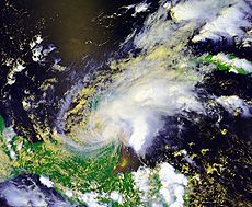
. Chantal reached a peak intensity of 70 mph (110 km/h) twice in the Caribbean Sea, and each time it was anticipated to attain hurricane status; however, wind shear and later land interaction prevented strengthening to hurricane status. On August 21 Chantal moved ashore near the border of Mexico and Belize, and the next day it dissipated.
In the Windward Islands, lightning caused two indirect deaths in Trinidad
. Chantal dropped light to moderate rainfall across its path, most significantly in Quintana Roo
in Mexico where it caused widespread mudslides. Damage in Belize
totaled $4 million (2001 USD; $ USD), due to the combined impact of high waves, moderate winds, and rainfall. Overall damage was minor.
quickly decreased after tracking westward through the tropical Atlantic Ocean
, although by August 13 a broad low pressure area
and closed circulation developed along the wave. Environmental conditions favored tropical development
, and the system gradually became better organized, although convection was initially limited near the center. On August 14, convection increased northwest of the center and became sufficiently well-organized for the system to be considered a tropical depression; at the time, it was located about 1500 miles (2400 km) east of the southern Windward Islands
.
Situated to the south of a strong subtropical ridge
, the depression tracked rapidly westward. With easterly wind shear
, the structure was initially disorganized, although the system was forecast to attain tropical storm status within 48 hours of developing, due to anticipated favorable conditions. One computer model predicted the depression would reach winds of around 115 miles per hour (185 km/h) by four days after development. Banding features increased while the satellite presentation continued to improve, and at 1200 UTC
on August 16 the depression was upgraded to Tropical Storm Chantal about 370 miles (595 km) east of Barbados
. At the same time however, a QuikSCAT
pass suggested the system did not contain a low-level circulation, and in post-season analysis, the National Hurricane Center
estimated the system degenerated into a tropical wave rather than attain tropical storm status. This was confirmed by a Hurricane Hunters
flight into the system.
Despite lacking a closed circulation, the overall structure remained well-organized, and with a favorable upper-level environment the possibility of regeneration into a tropical cyclone was noted. Early on August 17, the remnants of Chantal passed over the Windward Islands
with winds of tropical storm force. After entering the Caribbean Sea, the system slowed while its convective pattern expanded and became more symmetric. Hurricane Hunters confirmed that a small circulation developed about 290 miles (265 km) south of Saint Croix, and accordingly the system developed into a tropical storm. Forecasters described the upper-level environment as "ideal for [a] tropical cyclone to intensify", with winds of 80 miles per hour (130 km/h) forecast within a few days. The cyclone was predicted to maintain a west-northwestward track toward the northwestern Caribbean and Gulf of Mexico. On August 18, the winds increased to 65 miles per hour (105 km/h), although an increase in forward motion caused the low-level circulation to become separated from the deep convection. The storm again decelerated on August 19, allowing re-organization and for Chantal to attain peak sustained winds
of 70 miles per hour (110 km/h) about 185 miles (295 km) south of Kingston, Jamaica
.
After reaching peak winds, Tropical Storm Chantal became disorganized while the center became ill-defined and situated to the west-southwest of the main area of convection; this was due to unfavorable upper-level winds, although computer models continued to forecast a more favorable upper-level environment. By early on August 20, Hurricane Hunters reported several low-level circulations embedded within a large low pressure area. Later that day, wind shear decreased when the storm moved into the Gulf of Honduras
. Chantal became much better organized, again reaching peak winds of 70 miles per hour (110 km/h) before making landfall
early on August 21 near the border of Mexico and Belize. Initially, the storm was forecast to cross the Yucatán Peninsula
and Bay of Campeche
and make a second landfall in the state of Veracruz
. Chantal slowly weakened over land while moving slowly across northern Belize. Convection decreased markedly late on August 21, and early the next day Chantal weakened to tropical depression status. The upper- and middle-level circulations turned to the northeast while the low-level circulation turned to the west-southwest further inland. Weakening continued, and late on August 22 Chantal dissipated over the Mexican state of Tabasco
.
 The National Hurricane Center issued a tropical storm watch
for Barbados, St. Vincent
, and Saint Lucia
on August 15. The following day the watches were changed to warnings, since forecasters predicted that the system would reach tropical storm status. Additional watches and warnings were also issued for the rest of Windward Islands
.
Late on August 17, the government of Jamaica
issued a hurricane watch for the island, due to anticipated strengthening. The next day, it was upgraded to a hurricane warning briefly before being amended to a tropical storm warning, due to the storm's weakening in the central Caribbean. In the country, officials advised fishermen to return to harbor, while some flights into Norman Manley International Airport
were canceled. A tropical storm warning was also issued for the Cayman Islands
, where an emergency shelter was opened. There, tourists were recommended to temporarily leave the islands.
About 50 hours before landfall, a tropical storm watch was issued for Belize
and the eastern Yucatán Peninsula
, and about 12 hours later it was upgraded to a hurricane watch. When the lack of significant intensification became apparent, a tropical storm warning was added for much of the Yucatán Peninsula and later for a portion of the Mexican coast along the Bay of Campeche. As the storm approached, nearly 2,500 people in vulnerable areas of eastern Mexico evacuated to safer areas. About 8,000 people evacuated in Belize, primarily on offshore islands. The government of Belize opened its emergency operation center and evacuated several hospitals. About 250 airline flights were canceled, and some cruise ship paths were diverted to safer locations.
 As a strong tropical wave, Chantal passed through the Windward Islands
. The island of Martinique
reported sustained winds of 39 miles per hour (63 km/h) with gusts to 56 miles per hour (91 km/h). On August 16, lightning from the system killed two brothers in southern Trinidad. Also on the island, heavy rainfall caused flooding and road washouts.
While tracking across the eastern Caribbean Sea, the outer rainbands of Chantal produced light to moderate rainfall across Puerto Rico
and the United States Virgin Islands
. In Puerto Rico, the highest rainfall total was 2.4 inches (61 mm) in Rio Piedras
. Passing to the south of Jamaica
, the storm produced light rainfall and gusty winds. The outer rainbands also affected the Cayman Islands
.
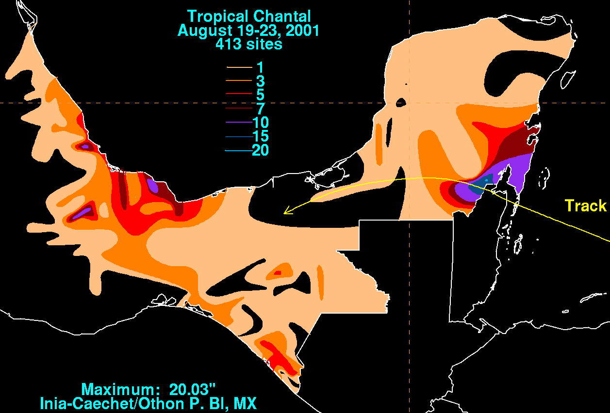
In Belize, the tropical storm produced a wind gust of 71 miles per hour (115 km/h) in Caye Caulker
, although stronger winds were possible in a convective band to the north. Moderate rainfall was reported across the country, peaking at 9.81 inches (249 mm) at Towerhill station. Along the coast, high waves damaged seawalls and piers. Further inland, the combination of winds and flooding caused agriculture and infrastructure damage; overall damage in the country totaled $4 million (2001 USD
; $ USD).
Tropical Storm Chantal also produced gusty winds in the Yucatán Peninsula
, peaking at 62 miles per hour (100 km/h) in Chetumal, Quintana Roo. Dropping moderate to heavy rainfall along its path, a station near Chetumal reported a peak total of 20.03 inches (509 mm). The remnants of Chantal also produced rainfall along the Bay of Campeche coast. The storm resulted in downed trees and power lines, as well as damaged buildings. Heavy rainfall led to mudslides across Quintana Roo
, leaving some areas isolated. Initially, there were reports of two missing fishermen off the southeastern coast, although it was not later confirmed. Overall damage was minor.
Atlantic hurricane
North Atlantic tropical cyclones usually form in the northern hemisphere summer or fall. Tropical cyclones can be categorized by intensity. Tropical storms have one-minute maximum sustained winds of at least 39 mph , while hurricanes have one-minute maximum sustained exceeding 74 mph...
tropical cyclone
Tropical cyclone
A tropical cyclone is a storm system characterized by a large low-pressure center and numerous thunderstorms that produce strong winds and heavy rain. Tropical cyclones strengthen when water evaporated from the ocean is released as the saturated air rises, resulting in condensation of water vapor...
that moved across the Caribbean Sea
Caribbean Sea
The Caribbean Sea is a sea of the Atlantic Ocean located in the tropics of the Western hemisphere. It is bounded by Mexico and Central America to the west and southwest, to the north by the Greater Antilles, and to the east by the Lesser Antilles....
in August 2001. Chantal developed from a tropical wave
Tropical wave
Tropical waves, easterly waves, or tropical easterly waves, also known as African easterly waves in the Atlantic region, are a type of atmospheric trough, an elongated area of relatively low air pressure, oriented north to south, which move from east to west across the tropics causing areas of...
on August 14 in the tropical Atlantic Ocean. It tracked rapidly westward for much of its duration, and after degenerating into a tropical wave it passed through the Windward Islands
Windward Islands
The Windward Islands are the southern islands of the Lesser Antilles, within the West Indies.-Name and geography:The Windward Islands are called such because they were more windward to sailing ships arriving in the New World than the Leeward Islands, given that the prevailing trade winds in the...
. Chantal reached a peak intensity of 70 mph (110 km/h) twice in the Caribbean Sea, and each time it was anticipated to attain hurricane status; however, wind shear and later land interaction prevented strengthening to hurricane status. On August 21 Chantal moved ashore near the border of Mexico and Belize, and the next day it dissipated.
In the Windward Islands, lightning caused two indirect deaths in Trinidad
Trinidad
Trinidad is the larger and more populous of the two major islands and numerous landforms which make up the island nation of Trinidad and Tobago. It is the southernmost island in the Caribbean and lies just off the northeastern coast of Venezuela. With an area of it is also the fifth largest in...
. Chantal dropped light to moderate rainfall across its path, most significantly in Quintana Roo
Quintana Roo
Quintana Roo officially Estado Libre y Soberano de Quintana Roo is one of the 31 states which, with the Federal District, comprise the 32 Federal Entities of Mexico. It is divided in 10 municipalities and its capital city is Chetumal....
in Mexico where it caused widespread mudslides. Damage in Belize
Belize
Belize is a constitutional monarchy and the northernmost country in Central America. Belize has a diverse society, comprising many cultures and languages. Even though Kriol and Spanish are spoken among the population, Belize is the only country in Central America where English is the official...
totaled $4 million (2001 USD; $ USD), due to the combined impact of high waves, moderate winds, and rainfall. Overall damage was minor.
Meteorological history
A tropical wave moved off the coast of Africa on August 11. Associated deep convectionConvection
Convection is the movement of molecules within fluids and rheids. It cannot take place in solids, since neither bulk current flows nor significant diffusion can take place in solids....
quickly decreased after tracking westward through the tropical Atlantic Ocean
Atlantic Ocean
The Atlantic Ocean is the second-largest of the world's oceanic divisions. With a total area of about , it covers approximately 20% of the Earth's surface and about 26% of its water surface area...
, although by August 13 a broad low pressure area
Low pressure area
A low-pressure area, or "low", is a region where the atmospheric pressure at sea level is below that of surrounding locations. Low-pressure systems form under areas of wind divergence which occur in upper levels of the troposphere. The formation process of a low-pressure area is known as...
and closed circulation developed along the wave. Environmental conditions favored tropical development
Tropical cyclogenesis
Tropical cyclogenesis is the term that describes the development and strengthening of a tropical cyclone in the atmosphere. The mechanisms through which tropical cyclogenesis occurs are distinctly different from those through which mid-latitude cyclogenesis occurs...
, and the system gradually became better organized, although convection was initially limited near the center. On August 14, convection increased northwest of the center and became sufficiently well-organized for the system to be considered a tropical depression; at the time, it was located about 1500 miles (2400 km) east of the southern Windward Islands
Windward Islands
The Windward Islands are the southern islands of the Lesser Antilles, within the West Indies.-Name and geography:The Windward Islands are called such because they were more windward to sailing ships arriving in the New World than the Leeward Islands, given that the prevailing trade winds in the...
.
Situated to the south of a strong subtropical ridge
Subtropical ridge
The subtropical ridge is a significant belt of high pressure situated around the latitudes of 30°N in the Northern Hemisphere and 30°S in the Southern Hemisphere. It is characterized by mostly calm winds, which acts to reduce air quality under its axis by causing fog overnight, and haze during...
, the depression tracked rapidly westward. With easterly wind shear
Wind shear
Wind shear, sometimes referred to as windshear or wind gradient, is a difference in wind speed and direction over a relatively short distance in the atmosphere...
, the structure was initially disorganized, although the system was forecast to attain tropical storm status within 48 hours of developing, due to anticipated favorable conditions. One computer model predicted the depression would reach winds of around 115 miles per hour (185 km/h) by four days after development. Banding features increased while the satellite presentation continued to improve, and at 1200 UTC
Coordinated Universal Time
Coordinated Universal Time is the primary time standard by which the world regulates clocks and time. It is one of several closely related successors to Greenwich Mean Time. Computer servers, online services and other entities that rely on having a universally accepted time use UTC for that purpose...
on August 16 the depression was upgraded to Tropical Storm Chantal about 370 miles (595 km) east of Barbados
Barbados
Barbados is an island country in the Lesser Antilles. It is in length and as much as in width, amounting to . It is situated in the western area of the North Atlantic and 100 kilometres east of the Windward Islands and the Caribbean Sea; therein, it is about east of the islands of Saint...
. At the same time however, a QuikSCAT
QuikSCAT
The QuikSCAT is an earth-observing satellite that provided estimates of wind speed and direction over the oceans to National Oceanic and Atmospheric Administration and others. This "quick recovery" mission intended to replace the NASA Scatterometer , which failed in June 1997...
pass suggested the system did not contain a low-level circulation, and in post-season analysis, the National Hurricane Center
National Hurricane Center
The National Hurricane Center , located at Florida International University in Miami, Florida, is the division of the National Weather Service responsible for tracking and predicting weather systems within the tropics between the Prime Meridian and the 140th meridian west poleward to the 30th...
estimated the system degenerated into a tropical wave rather than attain tropical storm status. This was confirmed by a Hurricane Hunters
Hurricane Hunters
The Hurricane Hunters are aircraft that fly into tropical cyclones in the North Atlantic Ocean and Northeastern Pacific Ocean for the specific purpose of directly measuring weather data in and around those storms. In the United States, the Air Force, Navy, and NOAA units have all participated in...
flight into the system.
Despite lacking a closed circulation, the overall structure remained well-organized, and with a favorable upper-level environment the possibility of regeneration into a tropical cyclone was noted. Early on August 17, the remnants of Chantal passed over the Windward Islands
Windward Islands
The Windward Islands are the southern islands of the Lesser Antilles, within the West Indies.-Name and geography:The Windward Islands are called such because they were more windward to sailing ships arriving in the New World than the Leeward Islands, given that the prevailing trade winds in the...
with winds of tropical storm force. After entering the Caribbean Sea, the system slowed while its convective pattern expanded and became more symmetric. Hurricane Hunters confirmed that a small circulation developed about 290 miles (265 km) south of Saint Croix, and accordingly the system developed into a tropical storm. Forecasters described the upper-level environment as "ideal for [a] tropical cyclone to intensify", with winds of 80 miles per hour (130 km/h) forecast within a few days. The cyclone was predicted to maintain a west-northwestward track toward the northwestern Caribbean and Gulf of Mexico. On August 18, the winds increased to 65 miles per hour (105 km/h), although an increase in forward motion caused the low-level circulation to become separated from the deep convection. The storm again decelerated on August 19, allowing re-organization and for Chantal to attain peak sustained winds
Maximum sustained wind
The maximum sustained winds associated with a tropical cyclone are a common indicator of the intensity of the storm. Within a mature tropical cyclone, they are found within the eyewall at a distance defined as the radius of maximum wind, or RMW. Unlike gusts, the value of these winds are...
of 70 miles per hour (110 km/h) about 185 miles (295 km) south of Kingston, Jamaica
Kingston, Jamaica
Kingston is the capital and largest city of Jamaica, located on the southeastern coast of the island. It faces a natural harbour protected by the Palisadoes, a long sand spit which connects the town of Port Royal and the Norman Manley International Airport to the rest of the island...
.
After reaching peak winds, Tropical Storm Chantal became disorganized while the center became ill-defined and situated to the west-southwest of the main area of convection; this was due to unfavorable upper-level winds, although computer models continued to forecast a more favorable upper-level environment. By early on August 20, Hurricane Hunters reported several low-level circulations embedded within a large low pressure area. Later that day, wind shear decreased when the storm moved into the Gulf of Honduras
Gulf of Honduras
The Gulf or Bay of Honduras is a large inlet of the Caribbean Sea, indenting the coasts of Belize, Guatemala, and Honduras. From north to south, it runs for approximately 200 km from Dangriga, Belize, to La Ceiba, Honduras....
. Chantal became much better organized, again reaching peak winds of 70 miles per hour (110 km/h) before making landfall
Landfall (meteorology)
Landfall is the event of a tropical cyclone or a waterspout coming onto land after being over water. When a waterspout makes landfall it is reclassified as a tornado, which can then cause damage inland...
early on August 21 near the border of Mexico and Belize. Initially, the storm was forecast to cross the Yucatán Peninsula
Yucatán Peninsula
The Yucatán Peninsula, in southeastern Mexico, separates the Caribbean Sea from the Gulf of Mexico, with the northern coastline on the Yucatán Channel...
and Bay of Campeche
Bay of Campeche
The Bay of Campeche is the southern bight of the Gulf of Mexico. It is surrounded on three sides by the Mexican states of Campeche, Tabasco and Veracruz. It was named by Francisco Hernández de Córdoba and Antonio de Alaminos during their expedition in 1517...
and make a second landfall in the state of Veracruz
Veracruz
Veracruz, formally Veracruz de Ignacio de la Llave officially Estado Libre y Soberano de Veracruz de Ignacio de la Llave , is one of the 31 states that, along with the Federal District, comprise the 32 federative entities of Mexico. It is divided in 212 municipalities and its capital city is...
. Chantal slowly weakened over land while moving slowly across northern Belize. Convection decreased markedly late on August 21, and early the next day Chantal weakened to tropical depression status. The upper- and middle-level circulations turned to the northeast while the low-level circulation turned to the west-southwest further inland. Weakening continued, and late on August 22 Chantal dissipated over the Mexican state of Tabasco
Tabasco
Tabasco officially Estado Libre y Soberano de Tabasco is one of the 31 states which, with the Federal District, comprise the 32 Federal Entities of Mexico. It is divided in 17 municipalities and its capital city is Villahermosa....
.
Preparations
Tropical cyclone warnings and watches
Warnings and watches are two levels of alert issued by national weather forecasting bodies to coastal areas threatened by the imminent approach of a tropical cyclone of tropical storm or hurricane intensity. They are notices to the local population and civil authorities to make appropriate...
for Barbados, St. Vincent
Saint Vincent and the Grenadines
Saint Vincent and the Grenadines is an island country in the Lesser Antilles chain, namely in the southern portion of the Windward Islands, which lie at the southern end of the eastern border of the Caribbean Sea where the latter meets the Atlantic Ocean....
, and Saint Lucia
Saint Lucia
Saint Lucia is an island country in the eastern Caribbean Sea on the boundary with the Atlantic Ocean. Part of the Lesser Antilles, it is located north/northeast of the island of Saint Vincent, northwest of Barbados and south of Martinique. It covers a land area of 620 km2 and has an...
on August 15. The following day the watches were changed to warnings, since forecasters predicted that the system would reach tropical storm status. Additional watches and warnings were also issued for the rest of Windward Islands
Windward Islands
The Windward Islands are the southern islands of the Lesser Antilles, within the West Indies.-Name and geography:The Windward Islands are called such because they were more windward to sailing ships arriving in the New World than the Leeward Islands, given that the prevailing trade winds in the...
.
Late on August 17, the government of Jamaica
Jamaica
Jamaica is an island nation of the Greater Antilles, in length, up to in width and 10,990 square kilometres in area. It is situated in the Caribbean Sea, about south of Cuba, and west of Hispaniola, the island harbouring the nation-states Haiti and the Dominican Republic...
issued a hurricane watch for the island, due to anticipated strengthening. The next day, it was upgraded to a hurricane warning briefly before being amended to a tropical storm warning, due to the storm's weakening in the central Caribbean. In the country, officials advised fishermen to return to harbor, while some flights into Norman Manley International Airport
Norman Manley International Airport
-Cargo :The following Cargo/Courier serve Norman Manley International Airport:-Accidents and incidents:*On 17 July 1960, the captain of a Vickers Viscount of Cubana de Aviación hijacked the aircraft on a flight from José Martí International Airport, Havana to Miami International Airport, Florida...
were canceled. A tropical storm warning was also issued for the Cayman Islands
Cayman Islands
The Cayman Islands is a British Overseas Territory and overseas territory of the European Union located in the western Caribbean Sea. The territory comprises the three islands of Grand Cayman, Cayman Brac, and Little Cayman, located south of Cuba and northwest of Jamaica...
, where an emergency shelter was opened. There, tourists were recommended to temporarily leave the islands.
About 50 hours before landfall, a tropical storm watch was issued for Belize
Belize
Belize is a constitutional monarchy and the northernmost country in Central America. Belize has a diverse society, comprising many cultures and languages. Even though Kriol and Spanish are spoken among the population, Belize is the only country in Central America where English is the official...
and the eastern Yucatán Peninsula
Yucatán Peninsula
The Yucatán Peninsula, in southeastern Mexico, separates the Caribbean Sea from the Gulf of Mexico, with the northern coastline on the Yucatán Channel...
, and about 12 hours later it was upgraded to a hurricane watch. When the lack of significant intensification became apparent, a tropical storm warning was added for much of the Yucatán Peninsula and later for a portion of the Mexican coast along the Bay of Campeche. As the storm approached, nearly 2,500 people in vulnerable areas of eastern Mexico evacuated to safer areas. About 8,000 people evacuated in Belize, primarily on offshore islands. The government of Belize opened its emergency operation center and evacuated several hospitals. About 250 airline flights were canceled, and some cruise ship paths were diverted to safer locations.
Impact
Windward Islands
The Windward Islands are the southern islands of the Lesser Antilles, within the West Indies.-Name and geography:The Windward Islands are called such because they were more windward to sailing ships arriving in the New World than the Leeward Islands, given that the prevailing trade winds in the...
. The island of Martinique
Martinique
Martinique is an island in the eastern Caribbean Sea, with a land area of . Like Guadeloupe, it is an overseas region of France, consisting of a single overseas department. To the northwest lies Dominica, to the south St Lucia, and to the southeast Barbados...
reported sustained winds of 39 miles per hour (63 km/h) with gusts to 56 miles per hour (91 km/h). On August 16, lightning from the system killed two brothers in southern Trinidad. Also on the island, heavy rainfall caused flooding and road washouts.
While tracking across the eastern Caribbean Sea, the outer rainbands of Chantal produced light to moderate rainfall across Puerto Rico
Puerto Rico
Puerto Rico , officially the Commonwealth of Puerto Rico , is an unincorporated territory of the United States, located in the northeastern Caribbean, east of the Dominican Republic and west of both the United States Virgin Islands and the British Virgin Islands.Puerto Rico comprises an...
and the United States Virgin Islands
United States Virgin Islands
The Virgin Islands of the United States are a group of islands in the Caribbean that are an insular area of the United States. The islands are geographically part of the Virgin Islands archipelago and are located in the Leeward Islands of the Lesser Antilles.The U.S...
. In Puerto Rico, the highest rainfall total was 2.4 inches (61 mm) in Rio Piedras
Río Piedras, Puerto Rico
Río Piedras is a district of San Juan, Puerto Rico. Founded in 1714, it has been the home of the University of Puerto Rico's main campus since 1903, earning the town the popular name of Ciudad Universitaria...
. Passing to the south of Jamaica
Jamaica
Jamaica is an island nation of the Greater Antilles, in length, up to in width and 10,990 square kilometres in area. It is situated in the Caribbean Sea, about south of Cuba, and west of Hispaniola, the island harbouring the nation-states Haiti and the Dominican Republic...
, the storm produced light rainfall and gusty winds. The outer rainbands also affected the Cayman Islands
Cayman Islands
The Cayman Islands is a British Overseas Territory and overseas territory of the European Union located in the western Caribbean Sea. The territory comprises the three islands of Grand Cayman, Cayman Brac, and Little Cayman, located south of Cuba and northwest of Jamaica...
.
In Belize, the tropical storm produced a wind gust of 71 miles per hour (115 km/h) in Caye Caulker
Caye Caulker
Caye Caulker is a small limestone coral island off the coast of Belize in the Caribbean Sea measuring about by less than . The town on the island is known by the name Caye Caulker Village...
, although stronger winds were possible in a convective band to the north. Moderate rainfall was reported across the country, peaking at 9.81 inches (249 mm) at Towerhill station. Along the coast, high waves damaged seawalls and piers. Further inland, the combination of winds and flooding caused agriculture and infrastructure damage; overall damage in the country totaled $4 million (2001 USD
United States dollar
The United States dollar , also referred to as the American dollar, is the official currency of the United States of America. It is divided into 100 smaller units called cents or pennies....
; $ USD).
Tropical Storm Chantal also produced gusty winds in the Yucatán Peninsula
Yucatán Peninsula
The Yucatán Peninsula, in southeastern Mexico, separates the Caribbean Sea from the Gulf of Mexico, with the northern coastline on the Yucatán Channel...
, peaking at 62 miles per hour (100 km/h) in Chetumal, Quintana Roo. Dropping moderate to heavy rainfall along its path, a station near Chetumal reported a peak total of 20.03 inches (509 mm). The remnants of Chantal also produced rainfall along the Bay of Campeche coast. The storm resulted in downed trees and power lines, as well as damaged buildings. Heavy rainfall led to mudslides across Quintana Roo
Quintana Roo
Quintana Roo officially Estado Libre y Soberano de Quintana Roo is one of the 31 states which, with the Federal District, comprise the 32 Federal Entities of Mexico. It is divided in 10 municipalities and its capital city is Chetumal....
, leaving some areas isolated. Initially, there were reports of two missing fishermen off the southeastern coast, although it was not later confirmed. Overall damage was minor.
See also
- Other tropical cyclones named Chantal
- Timeline of the 2001 Atlantic hurricane seasonTimeline of the 2001 Atlantic hurricane seasonThe timeline of the 2001 Atlantic hurricane season documents all the storm formations, strengthening, weakening, landfalls, extratropical transitions, as well as dissipation...