
QuikSCAT
Encyclopedia
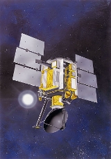
The QuikSCAT is an earth-observing satellite that provided estimates of wind speed and direction over the oceans to National Oceanic and Atmospheric Administration
and others. This "quick recovery" mission intended to replace the NASA Scatterometer (NSCAT), which failed in June 1997. The satellite launched on 19 June 1999 with an intended mission of two or three years. QuikSCAT, however, continued to operate for a decade and stopped working circa 23 November 2009, when the bearings in the motor of the spinning antenna failed.
When QuikSCAT operated normally and the antenna rotated, the spacecraft collected information on winds in strips 1800 kilometers wide on a daily basis. The QuikSCAT scatterometer still continues to provide useful remote sensing data over specific regions and giving scientists a way to test the accuracy of other space-based scatterometers. QuikSCAT operates in a sun-synchronous orbit
(low-earth orbit).
The QuikSCAT project was originally budgeted at $93 million, including the physical satellite, the launch rocket, and ongoing support for its science mission. A series of rocket failures in November 1998 grounded the Titan (rocket family)
launcher fleet, delayed the launch of QuickScat, and added $5 million to this initial cost.
A new instrument, the SeaWinds scatterometer, was attached to the satellite. The SeaWinds instrument, a specialized microwave radar system, measured both the speed and direction of winds near the ocean surface. It used two radars and a spinning antenna to record data across nine-tenths of the oceans of the world in a single day. It recorded roughly four hundred thousand wind measurements daily, each covering an area 1800 kilometres (1,118.5 mi) in width. Jet Propulsion Laboratory
and the NSCAT team jointly managed the project of construction of the satellite at the Goddard Space Flight Center
. Ball Aerospace & Technologies Corp. supplied the materials to construct the satellite.
In light of the record-setting construction time, engineers who worked on the project were given the American Electronics Achievement Award. This was only achieved due to the new type of contract made specifically for this satellite. Instead of the usual year given to select a contract and initiate development, it was constrained to one month.
The newly constructed satellite was set to launch on a Titan II
rocket from Vandenberg Air Force Base
in California. The rocket lifted off at 7:15 pm PDT on 19 June 1999. Roughly two minutes and thirty seconds after launch, the first engine was shut down and the second was engaged as it moved over the Baja California Peninsula
. A minute later, the nose cone, at the top of the rocket, separated into two parts. Sixteen seconds later, the rocket was re-oriented to protect the satellite from the sun. For the next 48 minutes, the two crafts flew over Antarctica and later over Madagascar, where the rocket reached its desired altitude of 500 mi (804.7 km).
At 59 minutes after launch, the satellite separated from the rocket and was pushed into its circular orbit around Earth. Shortly after, the solar arrays were deployed and connection was established with the satellite at 8:32 pm PDT with a tracking station in Norway. For the next two weeks, the shuttle used bursts from its engine to fine-tune its location and correct its course to the desired motion. Eighteen days after take-off, the scatterometer was turned on and a team of 12 personnel made detailed reviews of function of QuikSCAT. A month after entering orbit, the team completed the checks, and QuikSCAT began circling the globe constantly. NASA planned for the satellite to operate for two years.
s. The scatterometer's ability to record wind speeds at the surface allows meteorologists to determine whether a low pressure area is forming and enhance the ability to predict sudden changes in structure and strength. QuikSCAT continuously provided data from across the globe without error, "The data are looking great, better even than we expected." The first tropical cyclone captured by the SeaWinds instrument was Typhoon Olga in the western Pacific basin
. The system was constantly monitored by the satellite from its generation on July 28 to its demise in early August. Members of the QuikSCAT project believed that the satellite would eventually have a major role in climatological studies, weather prediction and oceanographic research.
During 2000, a public statement about the improvement of weather forecasting was attributed to the data provided by QuikSCAT. During the year, the satellite began recording wind directions, allowing forecasters to better predict when a storm could develop. Data was also provided in real-time for areas previously without recording devices, filling the information gaps across the world.
Other uses of the data include resource assessment for the emerging offshore wind energy industry. WindScan
has taken advantage of satellite data specifically for this purpose.
, the head of the National Hurricane Center
at the time, stated in a public message that the loss of the QuikSCAT satellite would greatly harm the quality of hurricane forecasts. This followed the loss of the main power source, leading to the satellite running on a backup generator. He claimed that three-day forecasts would be roughly 16% less accurate following the loss of QuikSCAT. However, this was found to be an exaggeration, during his controversial time at the center, which eventually led to him being removed from his position. Although the satellite aids in hurricane intensity, it does not do so exclusively and other satellites in orbit, with similar equipment, record the same information.
. The loss only affected the real-time scanning equipment; the long-term data collection remained intact and operational. According to NASA, the failure resulted from the age of the satellite. The mechanism that seized was designed to last only five years; however, it remained operational for roughly ten years, twice its expected use. On November 24, NASA managers began to assess how extensively affected the satellite was and if it was possible to restart the spinning antenna. Contigency plans for what to do in the event of QuikSCAT's failure were also reviewed.
forecasters occasionally cite the data provided by QuikSCAT, some do not feel that the value of the data warrants the expenditure that would be necessary for replacement of the satellite with a similar instrument, but rather advocate development of a more advanced satellite.
A joint project for creating a new satellite with the next generation of equipment has been announced by NASA and the NHC. The new satellite is scheduled to be operational in 2015, at which time it will be put in orbit around Earth.
National Oceanic and Atmospheric Administration
The National Oceanic and Atmospheric Administration , pronounced , like "noah", is a scientific agency within the United States Department of Commerce focused on the conditions of the oceans and the atmosphere...
and others. This "quick recovery" mission intended to replace the NASA Scatterometer (NSCAT), which failed in June 1997. The satellite launched on 19 June 1999 with an intended mission of two or three years. QuikSCAT, however, continued to operate for a decade and stopped working circa 23 November 2009, when the bearings in the motor of the spinning antenna failed.
When QuikSCAT operated normally and the antenna rotated, the spacecraft collected information on winds in strips 1800 kilometers wide on a daily basis. The QuikSCAT scatterometer still continues to provide useful remote sensing data over specific regions and giving scientists a way to test the accuracy of other space-based scatterometers. QuikSCAT operates in a sun-synchronous orbit
Sun-synchronous orbit
A Sun-synchronous orbit is a geocentric orbit which combines altitude and inclination in such a way that an object on that orbit ascends or descends over any given point of the Earth's surface at the same local mean solar time. The surface illumination angle will be nearly the same every time...
(low-earth orbit).
Construction and launch
In 1996, the NASA Scatterometer (NSCAT) was launched aboard the Japanese Advanced Earth Observing Satellite. This satellite was designed to record surface winds over water across the world for several years. However, an unexpected failure in 1997 led to an early termination of the NSCAT project. Following this briefly successful mission, NASA began constructing a new satellite to replace the failed one. They planned to build it and have it prepared for launch as soon as possible to limit the gap in data between the two satellites. In just 12 months, the Quick Scatterometer (QuikSCAT) satellite was constructed and ready to be launched, faster than any other NASA mission since the 1950s.The QuikSCAT project was originally budgeted at $93 million, including the physical satellite, the launch rocket, and ongoing support for its science mission. A series of rocket failures in November 1998 grounded the Titan (rocket family)
Titan (rocket family)
Titan was a family of U.S. expendable rockets used between 1959 and 2005. A total of 368 rockets of this family were launched, including all the Project Gemini manned flights of the mid-1960s...
launcher fleet, delayed the launch of QuickScat, and added $5 million to this initial cost.
A new instrument, the SeaWinds scatterometer, was attached to the satellite. The SeaWinds instrument, a specialized microwave radar system, measured both the speed and direction of winds near the ocean surface. It used two radars and a spinning antenna to record data across nine-tenths of the oceans of the world in a single day. It recorded roughly four hundred thousand wind measurements daily, each covering an area 1800 kilometres (1,118.5 mi) in width. Jet Propulsion Laboratory
Jet Propulsion Laboratory
Jet Propulsion Laboratory is a federally funded research and development center and NASA field center located in the San Gabriel Valley area of Los Angeles County, California, United States. The facility is headquartered in the city of Pasadena on the border of La Cañada Flintridge and Pasadena...
and the NSCAT team jointly managed the project of construction of the satellite at the Goddard Space Flight Center
Goddard Space Flight Center
The Goddard Space Flight Center is a major NASA space research laboratory established on May 1, 1959 as NASA's first space flight center. GSFC employs approximately 10,000 civil servants and contractors, and is located approximately northeast of Washington, D.C. in Greenbelt, Maryland, USA. GSFC,...
. Ball Aerospace & Technologies Corp. supplied the materials to construct the satellite.
In light of the record-setting construction time, engineers who worked on the project were given the American Electronics Achievement Award. This was only achieved due to the new type of contract made specifically for this satellite. Instead of the usual year given to select a contract and initiate development, it was constrained to one month.
The newly constructed satellite was set to launch on a Titan II
Titan 23G
The Titan 23G, Titan IIG, Titan 2G or Titan II SLV was an American expendable launch system derived from the LGM-25C Titan II intercontinental ballistic missile. Retired Titan II missiles were converted by Martin Marietta, into which the Glenn L. Martin Company, which built the original Titan II,...
rocket from Vandenberg Air Force Base
Vandenberg Air Force Base
Vandenberg Air Force Base is a United States Air Force Base, located approximately northwest of Lompoc, California. It is under the jurisdiction of the 30th Space Wing, Air Force Space Command ....
in California. The rocket lifted off at 7:15 pm PDT on 19 June 1999. Roughly two minutes and thirty seconds after launch, the first engine was shut down and the second was engaged as it moved over the Baja California Peninsula
Baja California Peninsula
The Baja California peninsula , is a peninsula in northwestern Mexico. Its land mass separates the Pacific Ocean from the Gulf of California. The Peninsula extends from Mexicali, Baja California in the north to Cabo San Lucas, Baja California Sur in the south.The total area of the Baja California...
. A minute later, the nose cone, at the top of the rocket, separated into two parts. Sixteen seconds later, the rocket was re-oriented to protect the satellite from the sun. For the next 48 minutes, the two crafts flew over Antarctica and later over Madagascar, where the rocket reached its desired altitude of 500 mi (804.7 km).
At 59 minutes after launch, the satellite separated from the rocket and was pushed into its circular orbit around Earth. Shortly after, the solar arrays were deployed and connection was established with the satellite at 8:32 pm PDT with a tracking station in Norway. For the next two weeks, the shuttle used bursts from its engine to fine-tune its location and correct its course to the desired motion. Eighteen days after take-off, the scatterometer was turned on and a team of 12 personnel made detailed reviews of function of QuikSCAT. A month after entering orbit, the team completed the checks, and QuikSCAT began circling the globe constantly. NASA planned for the satellite to operate for two years.
Uses
Not long after being activated, the data collected by the satellite proved to be very useful in forecasting tropical cycloneTropical cyclone
A tropical cyclone is a storm system characterized by a large low-pressure center and numerous thunderstorms that produce strong winds and heavy rain. Tropical cyclones strengthen when water evaporated from the ocean is released as the saturated air rises, resulting in condensation of water vapor...
s. The scatterometer's ability to record wind speeds at the surface allows meteorologists to determine whether a low pressure area is forming and enhance the ability to predict sudden changes in structure and strength. QuikSCAT continuously provided data from across the globe without error, "The data are looking great, better even than we expected." The first tropical cyclone captured by the SeaWinds instrument was Typhoon Olga in the western Pacific basin
Pacific typhoon
A typhoon is a mature tropical cyclone that develops in the northwestern part of the Pacific Ocean between 180° and 100°E. This region is referred to as the northwest Pacific basin. For organizational purposes, the northern Pacific Ocean is divided into three regions: the eastern , central , and...
. The system was constantly monitored by the satellite from its generation on July 28 to its demise in early August. Members of the QuikSCAT project believed that the satellite would eventually have a major role in climatological studies, weather prediction and oceanographic research.
During 2000, a public statement about the improvement of weather forecasting was attributed to the data provided by QuikSCAT. During the year, the satellite began recording wind directions, allowing forecasters to better predict when a storm could develop. Data was also provided in real-time for areas previously without recording devices, filling the information gaps across the world.
Other uses of the data include resource assessment for the emerging offshore wind energy industry. WindScan
WindScan
WindScan contains globally gridded, high resolution offshore wind speeds and directions on a 0.250 global grid and multiple time resolutions down to 6 hourly measurements...
has taken advantage of satellite data specifically for this purpose.
2007 Bill Proenza controversy
In 2007, Bill ProenzaBill Proenza
Xavier William "Bill" Proenza is the Southern Region Director of the United States National Weather Service. He was previously the director of the National Hurricane Center from January 4, 2007 to July 9, 2007. Before that Proenza was Southern Region Director from 1999 to 2007.-History:Bill...
, the head of the National Hurricane Center
National Hurricane Center
The National Hurricane Center , located at Florida International University in Miami, Florida, is the division of the National Weather Service responsible for tracking and predicting weather systems within the tropics between the Prime Meridian and the 140th meridian west poleward to the 30th...
at the time, stated in a public message that the loss of the QuikSCAT satellite would greatly harm the quality of hurricane forecasts. This followed the loss of the main power source, leading to the satellite running on a backup generator. He claimed that three-day forecasts would be roughly 16% less accurate following the loss of QuikSCAT. However, this was found to be an exaggeration, during his controversial time at the center, which eventually led to him being removed from his position. Although the satellite aids in hurricane intensity, it does not do so exclusively and other satellites in orbit, with similar equipment, record the same information.
2009 sensor loss
During mid-2009, the QuikSCAT project began noticing a gradual deterioration in the bearings that allow the antenna that provides real-time data. The bearings produced more friction than in the past nine years the satellite was in orbit. This friction slowed the rate the antenna spun, leading to gaps in data recorded by QuikSCAT across the world. This culimated in the antenna's failure on November 23, 2009. Upon failing, it was announced that the satellite was likely at the end of its mission and would no longer be used. The sensor on the satellite was confirmed to have failed around 0700 UTCCoordinated Universal Time
Coordinated Universal Time is the primary time standard by which the world regulates clocks and time. It is one of several closely related successors to Greenwich Mean Time. Computer servers, online services and other entities that rely on having a universally accepted time use UTC for that purpose...
. The loss only affected the real-time scanning equipment; the long-term data collection remained intact and operational. According to NASA, the failure resulted from the age of the satellite. The mechanism that seized was designed to last only five years; however, it remained operational for roughly ten years, twice its expected use. On November 24, NASA managers began to assess how extensively affected the satellite was and if it was possible to restart the spinning antenna. Contigency plans for what to do in the event of QuikSCAT's failure were also reviewed.
Replacement
Replacement of this satellite remains a topic of debate. Although NHCNational Hurricane Center
The National Hurricane Center , located at Florida International University in Miami, Florida, is the division of the National Weather Service responsible for tracking and predicting weather systems within the tropics between the Prime Meridian and the 140th meridian west poleward to the 30th...
forecasters occasionally cite the data provided by QuikSCAT, some do not feel that the value of the data warrants the expenditure that would be necessary for replacement of the satellite with a similar instrument, but rather advocate development of a more advanced satellite.
A joint project for creating a new satellite with the next generation of equipment has been announced by NASA and the NHC. The new satellite is scheduled to be operational in 2015, at which time it will be put in orbit around Earth.