

Transport in Berlin
Encyclopedia
Berlin
Berlin is the capital city of Germany and is one of the 16 states of Germany. With a population of 3.45 million people, Berlin is Germany's largest city. It is the second most populous city proper and the seventh most populous urban area in the European Union...
has developed a highly complex transportation infrastructure providing very diverse modes of urban mobility. 979 bridges cross 197 kilometers of innercity waterways, 5334 kilometres (3,314 mi) of roads run through Berlin, of which 73 kilometres (45 mi) are motorways.
Long-distance rail lines connect Berlin with all of the major cities of Germany and with many cities in neighboring European countries. Regional rail lines provide access to the surrounding regions of Brandenburg
Brandenburg
Brandenburg is one of the sixteen federal-states of Germany. It lies in the east of the country and is one of the new federal states that were re-created in 1990 upon the reunification of the former West Germany and East Germany. The capital is Potsdam...
and to the Baltic Sea
Baltic Sea
The Baltic Sea is a brackish mediterranean sea located in Northern Europe, from 53°N to 66°N latitude and from 20°E to 26°E longitude. It is bounded by the Scandinavian Peninsula, the mainland of Europe, and the Danish islands. It drains into the Kattegat by way of the Øresund, the Great Belt and...
.
Road transport
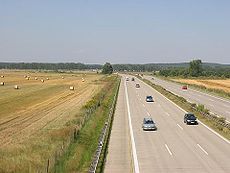
In 2006, 1.416 million motor vehicles were registered in the city. With 416 vehicles per 1000 inhabitants (587/1000 in Germany), Berlin as a German state and as a major European city has one of the lowest numbers of cars per capita.Autobahn links
Berlin is linked to the rest of Germany and neighbouring countries by the country's autobahn network, including the:- A2 to Hannover and the Ruhr areaRuhr AreaThe Ruhr, by German-speaking geographers and historians more accurately called Ruhr district or Ruhr region , is an urban area in North Rhine-Westphalia, Germany. With 4435 km² and a population of some 5.2 million , it is the largest urban agglomeration in Germany...
, with links to Frankfurt am Main and western Germany - A9 to LeipzigLeipzigLeipzig Leipzig has always been a trade city, situated during the time of the Holy Roman Empire at the intersection of the Via Regia and Via Imperii, two important trade routes. At one time, Leipzig was one of the major European centres of learning and culture in fields such as music and publishing...
, NurembergNurembergNuremberg[p] is a city in the German state of Bavaria, in the administrative region of Middle Franconia. Situated on the Pegnitz river and the Rhine–Main–Danube Canal, it is located about north of Munich and is Franconia's largest city. The population is 505,664...
and MunichMunichMunich The city's motto is "" . Before 2006, it was "Weltstadt mit Herz" . Its native name, , is derived from the Old High German Munichen, meaning "by the monks' place". The city's name derives from the monks of the Benedictine order who founded the city; hence the monk depicted on the city's coat...
, with links to Frankfurt am Main and southern Germany - A11Bundesautobahn 11is an autobahn in eastern Germany that was opened in 1936. As it is partly in a dilapidated state, it is currently undergoing modernisation works on various stretches...
to SzczecinSzczecinSzczecin , is the capital city of the West Pomeranian Voivodeship in Poland. It is the country's seventh-largest city and the largest seaport in Poland on the Baltic Sea. As of June 2009 the population was 406,427....
, with links to north-east Germany and PolandPolandPoland , officially the Republic of Poland , is a country in Central Europe bordered by Germany to the west; the Czech Republic and Slovakia to the south; Ukraine, Belarus and Lithuania to the east; and the Baltic Sea and Kaliningrad Oblast, a Russian exclave, to the north... - A12Bundesautobahn 12is an autobahn in eastern Germany, connecting Berlin to the Polish border.- Exit list :...
to Frankfurt (Oder)Frankfurt (Oder)Frankfurt is a town in Brandenburg, Germany, located on the Oder River, on the German-Polish border directly opposite the town of Słubice which was a part of Frankfurt until 1945. At the end of the 1980s it reached a population peak with more than 87,000 inhabitants...
, with links to Poland - A13 to DresdenDresdenDresden is the capital city of the Free State of Saxony in Germany. It is situated in a valley on the River Elbe, near the Czech border. The Dresden conurbation is part of the Saxon Triangle metropolitan area....
, with links to Poland and the Czech RepublicCzech RepublicThe Czech Republic is a landlocked country in Central Europe. The country is bordered by Poland to the northeast, Slovakia to the east, Austria to the south, and Germany to the west and northwest.... - A24Bundesautobahn 24is an autobahn in northern Germany that connects the large metropolitan regions of Hamburg and Berlin. It was one of the three transit access roads to West Berlin during the Cold War....
to HamburgHamburg-History:The first historic name for the city was, according to Claudius Ptolemy's reports, Treva.But the city takes its modern name, Hamburg, from the first permanent building on the site, a castle whose construction was ordered by the Emperor Charlemagne in AD 808...
, with links to north-west Germany
Bundesautobahn 10
runs in Brandenburg and is an orbital motorway around Berlin and is therefore called the Berliner Ring. It should not be confused with the Berliner Stadtring ....
, a 196 kilometres (121.8 mi) autobahn that encircles the city at some distance from the centre, and largely in the surrounding state of Brandenburg
Brandenburg
Brandenburg is one of the sixteen federal-states of Germany. It lies in the east of the country and is one of the new federal states that were re-created in 1990 upon the reunification of the former West Germany and East Germany. The capital is Potsdam...
. Central Berlin is connected to the A10 by several shorter autobahns:
- A111 to the northwest (towards the A24 and Tegel Airport)
- A113Bundesautobahn 113is a motorway in Germany. The motorway connects Neukölln to Schönefeld . Its latest part was released on 23 May 2008....
to the southeast (towards the A12, A13 and Schönefeld Airport) - A114Bundesautobahn 114is a motorway in the north of the German capital Berlin. It connects the A 10 starting at the Autobahndreieck Pankow over a seven kilometers distance to the main center of Berlin. The motorway was released for traffic between 1973 and 1982....
to the north (towards the A11) - A115Bundesautobahn 115is an autobahn in Berlin, Germany. It connects the Berliner Stadtring with the Berliner Ring, using parts of the old AVUS race track. AVUS was opened in 1921 as Germany's first limited access road. After World War II, the A 115 served an important function as a transit road between West Berlin...
to the southwest (towards the A2 and A9)
The A111, A113 and A115 connect with the A100 Berliner Stadtring
Bundesautobahn 100
is an Autobahn in Germany. The A 100 encloses the city centre of the German capital Berlin, running from the Wedding district of the Berlin-Mitte borough in a southwestern bow through Charlottenburg-Wilmersdorf and Tempelhof-Schöneberg to Neukölln...
, an autobahn that forms a half circle to the west of the inner city, and is one of the busiest motorways in Germany. There are plans to extend this motorway to form a full circle around the inner city.
Cycling
Berlin is known for its highly developed bike lane system. Around 1,500,000 daily rides account for 13% of total traffic in 2008. The Senate of BerlinSenate of Berlin
The Senate of Berlin is the executive body governing the city of Berlin, which at the same time is a state of Germany. According to the Constitution of Berlin the Senate consists of the Governing Mayor of Berlin and up to eight Senators appointed by the Governing Mayor, two of whom are appointed ...
aims to increase the number to 18-20% of city traffic by the year 2025. Riders have access to 620 kilometres (385.3 mi) of bike paths including some 150 kilometres (93.2 mi) of mandatory bicycle paths, 190 kilometres (118.1 mi) of off-road bicycle routes, 60 kilometres (37.3 mi) of bike lanes on the roads, 70 kilometres (43.5 mi) of shared bus lanes which are also open to bicyclists, 100 kilometres (62.1 mi) of combined pedestrian/bike paths and 50 kilometres (31.1 mi) of marked bike lanes on sidewalks. A system of bike-sharing stations across the city cetre is being implemented by Deutsche Bahn
Deutsche Bahn
Deutsche Bahn AG is the German national railway company, a private joint stock company . Headquartered in Berlin, it came into existence in 1994 as the successor to the former state railways of Germany, the Deutsche Bundesbahn of West Germany and the Deutsche Reichsbahn of East Germany...
since 2011, starting in Prenzlauer Berg
Prenzlauer Berg
Prenzlauer Berg is a locality of Berlin, in the borough of Pankow.Until 2001, Prenzlauer Berg was a borough of Berlin; in that year it was included in the borough of Pankow....
and Mitte
Water transport
Berlin is linked to the Baltic SeaBaltic Sea
The Baltic Sea is a brackish mediterranean sea located in Northern Europe, from 53°N to 66°N latitude and from 20°E to 26°E longitude. It is bounded by the Scandinavian Peninsula, the mainland of Europe, and the Danish islands. It drains into the Kattegat by way of the Øresund, the Great Belt and...
, the North Sea
North Sea
In the southwest, beyond the Straits of Dover, the North Sea becomes the English Channel connecting to the Atlantic Ocean. In the east, it connects to the Baltic Sea via the Skagerrak and Kattegat, narrow straits that separate Denmark from Norway and Sweden respectively...
, and the River Rhine by an extensive network of rivers, lakes and canals. An equally extensive network of waterways exists within the city boundaries, providing local access and various short-cuts. The waterways accommodate a mixture of commercial traffic, sightseeing tour boats, ferries and a large fleet of private leisure boats.
The waterways of Berlin
Berlin city centre is located on the River SpreeSpree
The Spree is a river that flows through the Saxony, Brandenburg and Berlin states of Germany, and in the Ústí nad Labem region of the Czech Republic...
, which runs roughly east to west across the city. The River Dahme joins the Spree at Köpenick
Köpenick
Köpenick is a historic town and locality that is situated at the confluence of the rivers Dahme and Spree in the south-east of the German capital city of Berlin. It was formerly known as Copanic and then Cöpenick, only officially adopting the current spelling in 1931...
, in the city's eastern suburbs. At Spandau
Spandau
Spandau is the fifth of the twelve boroughs of Berlin. It is the fourth largest and westernmost borough, situated at the confluence of the Havel and Spree rivers and along the western bank of the Havel, but the least populated.-Overview:...
the Spree joins the River Havel
Havel
The Havel is a river in north-eastern Germany, flowing through the German states of Mecklenburg-Vorpommern, Brandenburg, Berlin and Saxony-Anhalt. It is a right tributary of the Elbe river and in length...
, which flows roughly north to south along the city's western boundary. To both east and west of the centre of Berlin, all three of these rivers flow through substantial chains of lakes. These include the Tegeler See and Großer Wannsee
Großer Wannsee
The Großer Wannsee is a bight of the Havel river near the locality of Wannsee and Nikolassee , a south-western suburb of the German capital Berlin not far from Potsdam...
to the west, and the Müggelsee
Müggelsee
The Müggelsee, also known as the Großer Müggelsee, is a lake in the eastern suburbs of Berlin, the capital city of Germany. It is the largest of the Berlin lakes by area, with an area of , a length of and a breadth of . The lake is in the Berlin district of Treptow-Köpenick...
, Langer See
Langer See
The Langer See is a lake situated in the south-eastern outskirts of Berlin, the capital city of Germany. The lake is aligned south-east to north-west and forms part of the course of the River Dahme...
, Seddinsee
Seddinsee
The Seddinsee is a lake situated in the south-eastern outskirts of Berlin, the capital city of Germany. The lake is aligned south-west to north-east, with its south-western end adjacent to the Berlin suburb of Schmöckwitz. Here the Seddinsee meets the Zeuthener See and Langer See, two lakes which...
and Zeuthener See
Zeuthener See
The Zeuthener See is a lake situated to the south-east of Berlin, the capital city of Germany, in the states of Berlin and Brandenburg. At an elevation of , its surface area is .-Overview:...
to the east.
The Elbe–Havel Canal links the River Havel downstream of Spandau with both the River Elbe
Elbe
The Elbe is one of the major rivers of Central Europe. It rises in the Krkonoše Mountains of the northwestern Czech Republic before traversing much of Bohemia , then Germany and flowing into the North Sea at Cuxhaven, 110 km northwest of Hamburg...
, which flows into the North Sea at Hamburg
Hamburg
-History:The first historic name for the city was, according to Claudius Ptolemy's reports, Treva.But the city takes its modern name, Hamburg, from the first permanent building on the site, a castle whose construction was ordered by the Emperor Charlemagne in AD 808...
, and with the Mittelland Canal, which stretches across Germany to a network of canals that provide a link to the River Rhine. Both the Oder–Havel and Oder–Spree
Oder–Spree Canal
The Oder-Spree Canal, or the Oder-Spree-Kanal in German, is a canal in the east of Germany. It links the Dahme river, at Schmöckwitz in the south-eastern suburbs of Berlin, with the River Oder, at Eisenhüttenstadt. It provides an important commercial navigable connection between Berlin and the...
canals provide routes from the Berlin area to the River Oder
Oder
The Oder is a river in Central Europe. It rises in the Czech Republic and flows through western Poland, later forming of the border between Poland and Germany, part of the Oder-Neisse line...
, which flows into the Baltic Sea near Szczecin
Szczecin
Szczecin , is the capital city of the West Pomeranian Voivodeship in Poland. It is the country's seventh-largest city and the largest seaport in Poland on the Baltic Sea. As of June 2009 the population was 406,427....
and provides links to Poland
Poland
Poland , officially the Republic of Poland , is a country in Central Europe bordered by Germany to the west; the Czech Republic and Slovakia to the south; Ukraine, Belarus and Lithuania to the east; and the Baltic Sea and Kaliningrad Oblast, a Russian exclave, to the north...
. The Oder-Havel Canal links with the River Havel north of Spandau, whilst the Oder-Spree Canal links with the River Dahme east of Köpenick.
The most important canals within Berlin run roughly east to west between the rivers Spree and Havel. The canal system to the north of the Spree begins with the Berlin-Spandau Ship Canal
Berlin-Spandau Ship Canal
The Berlin-Spandau Ship Canal, or Berlin-Spandauer Schifffahrtskanal in German, is a canal in Berlin, Germany. It was built between 1848 and 1859 to a plan created by Peter Joseph Lenné, and was formerly known as the Hohenzollern Canal or Hohenzollernkanal.The long canal links the River Havel...
, which runs from the Spree near the Hauptbahnhof
Berlin Hauptbahnhof
' , is the main railway station in Berlin, Germany. It began full operation two days after a ceremonial opening on 26 May 2006. It is located on the site of the historic Lehrter Bahnhof, and until it opened as a main line station, it was a stop on the Berlin S-Bahn suburban railway temporarily...
to the River Havel above Spandau
Spandau
Spandau is the fifth of the twelve boroughs of Berlin. It is the fourth largest and westernmost borough, situated at the confluence of the Havel and Spree rivers and along the western bank of the Havel, but the least populated.-Overview:...
. The Westhafen Canal
Westhafen Canal
The Westhafen Canal, or Westhafenkanal in German, is a canal in Berlin, Germany. The long canal connects with the Westhafen inland port and the Berlin-Spandau Ship Canal at its eastern end, and with the River Spree in Charlottenburg at its western end...
and the Charlottenburg Canal
Charlottenburg Canal
The Charlottenburg Canal, or Charlottenburger Verbindungskanal in German, is a canal in Berlin, Germany.With a former length of , the canal was built between 1848 and 1859, and originally connected the River Spree, in Charlottenburg, with the Berlin-Spandau Ship Canal...
, both near Charlottenburg
Charlottenburg
Charlottenburg is a locality of Berlin within the borough of Charlottenburg-Wilmersdorf, named after Queen consort Sophia Charlotte...
, provide further connections between the Berlin-Spandau Ship Canal and the River Spree.
The main canal to the south of the Spree is the Teltow Canal
Teltow Canal
The Teltow Canal, also known as the Teltowkanal in German, is a canal to the south of Berlin, the capital city of Germany. The canal lies in both the states of Berlin and Brandenburg, and at points forms the boundary between the two...
, which runs from the Dahme south of Köpenick
Köpenick
Köpenick is a historic town and locality that is situated at the confluence of the rivers Dahme and Spree in the south-east of the German capital city of Berlin. It was formerly known as Copanic and then Cöpenick, only officially adopting the current spelling in 1931...
through the southern part of Berlin to an arm of the Havel just east of Potsdam
Potsdam
Potsdam is the capital city of the German federal state of Brandenburg and part of the Berlin/Brandenburg Metropolitan Region. It is situated on the River Havel, southwest of Berlin city centre....
. A shorter canal, the Landwehr Canal, parallels the Spree through the centre of Berlin. It begins at the Spree between Treptow
Treptow
Treptow is a former borough in the southeast of Berlin. It merged with Köpenick to form Treptow-Köpenick in 2001.-Geography:The district was composed by the localities of Alt-Treptow, Plänterwald, Baumschulenweg, Niederschöneweide, Johannisthal, Adlershof, Altglienicke and Bohnsdorf....
and Kreuzberg
Kreuzberg
Kreuzberg, a part of the combined Friedrichshain-Kreuzberg borough located south of Mitte since 2001, is one of the best-known areas of Berlin...
and rejoins the Spree in Charlottenburg. The Neukölln Ship Canal
Neukölln Ship Canal
The Neukölln Ship Canal, or Neuköllner Schiffahrtskanal, is a long canal in Berlin, Germany. It connects with the Landwehr Canal at its northern end, and with the Teltow Canal and the Britz Canal at its southern end....
connects the Landwehr Canal with the Teltow Canal; while the Britz Canal
Britz Canal
The Britz Canal, or Britzer Verbindungskanal in German, is a long canal in Berlin, Germany. The canal was built between 1900 and 1906, and was previously known as the Britz Branch Canal or Britzer Zweigkanal....
connects the Teltow Canal with the Spree at Baumschulenweg.
Whilst not within Berlin, the existence of the city and its partition led to the construction of the Havel Canal
Havel Canal
The Havel Canal, or Havelkanal in German, is a canal in the German state of Brandenburg. It provides an alternate route to the River Havel, between Hennigsdorf and Paretz, thus avoiding a passage through the waterways of Berlin between Spandau and Potsdam.Construction of the canal was authorised by...
in 1951-2. This canal provides an alternative route between Hennigsdorf
Hennigsdorf
Hennigsdorf is a town in the district of Oberhavel, in Brandenburg, Germany. It is situated north-west of Berlin, just across the city border, which is formed mainly by the Havel river.-History:...
and Paretz, both then in East Germany, and avoids the stretch of the River Havel that was under the political control of West Berlin
West Berlin
West Berlin was a political exclave that existed between 1949 and 1990. It comprised the western regions of Berlin, which were bordered by East Berlin and parts of East Germany. West Berlin consisted of the American, British, and French occupation sectors, which had been established in 1945...
.
Waterborne traffic
Berlin's largest port is the Westhafen ("west port"), in MoabitMoabit
Moabit is an inner city locality of Berlin. Since Berlin's 2001 administrative reform it belongs to the newly regrouped governmental borough of Mitte. Previously, from 1920 to 2001, it belonged to the borough of Tiergarten. Moabit's borders are defined by three watercourses, the Spree, the...
(Mitte), with an area of 173,000 m² (42.75 acre
Acre
The acre is a unit of area in a number of different systems, including the imperial and U.S. customary systems. The most commonly used acres today are the international acre and, in the United States, the survey acre. The most common use of the acre is to measure tracts of land.The acre is related...
s). It lies at the intersection of the Berlin-Spandau Ship Canal and the Westhafen Canal. It handles the shipping of grain and pieced and heavy goods. The Südhafen ("south port"), which actually lies along the Havel in Spandau, in far western Berlin, covers an area of about 103,000 m² (25.5 acres) and also handles the shipping of pieced and heavy goods. The Osthafen ("east port"), with an area of 57,500 m² (14.2 acres), lies along the Spree in Friedrichshain. The Hafen Neukölln, with only 19,000 m² (4.7 acres), is located along the Neuköllner Ship Canal in Neukölln
Neukölln
Neukölln is the eighth borough of Berlin, located in the southeastern part of the city and was part of the former American sector under the Four-Power occupation of the city...
. It handles the shipping of building materials.
Sightseeing boats operate on the central section of the River Spree and its adjoining waterways on a frequent basis. Common tours operated include short tours on the River Spree in the city centre, and a three hour circuit of the city centre via the River Spree and the Landwehr Canal. Other sightseeing boats operate on the various lakes to the east and west of Berlin.
Several ferry services operate on and across Berlin's waterways (see ferries below).
Public transport
Berlin's local public transport network consists of several integrated systems. These include the U-Bahn and S-Bahn urban rail systems, regional railway services, a tramway system, a bus network and a number of ferry services. There are a large number of common interchange stations between the different modes.All these services form part of the common public transport tariff run by the Verkehrsverbund Berlin-Brandenburg
Verkehrsverbund Berlin-Brandenburg
The Verkehrsverbund Berlin-Brandenburg is a transport association run by public transport providers in the German states of Berlin and Brandenburg. It is a private limited company owned jointly by the states of Berlin and Brandenburg and the 18 counties and cities of Brandenburg with 1.85% each...
(VBB). This covers the city of Berlin and approximately 15 kilometres (9.3 mi) beyond the city boundaries. The area is split into three zones. Zone A is the central parts of the city (inside the Ringbahn), and zone B is the outer parts of Berlin City. Zone C covers an area beyond the city boundaries.
Ticket fares have a slight price difference between these three zones. For instance in June 2010, a one-day ticket for zone A+B was priced at €6.10, a zone B+C one-day travel ticket was €6.30, and for all three zones A+B+C, the price was €6.50.
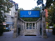
U-Bahn
The U-Bahn is an urban rapid transitRapid transit
A rapid transit, underground, subway, elevated railway, metro or metropolitan railway system is an electric passenger railway in an urban area with a high capacity and frequency, and grade separation from other traffic. Rapid transit systems are typically located either in underground tunnels or on...
rail system, and is entirely within the city borders. Whilst the majority of the system is underground, significant sections operate on elevated tracks or at street level. It is operated by the Berliner Verkehrsbetriebe
Berliner Verkehrsbetriebe
The is the main public transport company of Berlin, the capital city of Germany. It manages the city's U-Bahn underground railway, tram, bus and ferry networks, but not the S-Bahn urban rail system....
(BVG), the city owned municipal transport operator, and uses the common public transport tariff managed by the Verkehrsverbund Berlin-Brandenburg
Verkehrsverbund Berlin-Brandenburg
The Verkehrsverbund Berlin-Brandenburg is a transport association run by public transport providers in the German states of Berlin and Brandenburg. It is a private limited company owned jointly by the states of Berlin and Brandenburg and the 18 counties and cities of Brandenburg with 1.85% each...
(VBB).
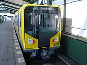
The U-Bahn now comprises nine lines with 173 stations and a total length of 147 kilometres (91.3 mi). Trains run every two to five minutes during peak hours, every five minutes for the rest of the day and every ten minutes in the evening and on Sunday. They travel 132 million km (83 million mi), carrying 400 million passengers, over the year.
During the division of the city, the U-Bahn system was itself partitioned. One line – the U5
U5 (Berlin U-Bahn)
U5 is a line on the Berlin U-Bahn. It runs from Alexanderplatz in Mitte eastwards through Friedrichshain, Lichtenberg and Friedrichsfelde, surfaces in Biesdorf to pass Kaulsdorf and Hellersdorf above ground and finally reaches city limits at Hönow....
– was entirely within East Berlin
East Berlin
East Berlin was the name given to the eastern part of Berlin between 1949 and 1990. It consisted of the Soviet sector of Berlin that was established in 1945. The American, British and French sectors became West Berlin, a part strongly associated with West Germany but a free city...
, and another – the U2
U2 (Berlin U-Bahn)
U2 is a line on the Berlin U-Bahn. The U2 line starts at the Pankow urban rail station, runs through the eastern city centre to Potsdamer Platz, the western city centre and finally to the Ruhleben terminal station.The U2 has 29 stations and a length of...
– was operated in two sections, one by each of the two sides. The remaining lines were nominally within West Berlin
West Berlin
West Berlin was a political exclave that existed between 1949 and 1990. It comprised the western regions of Berlin, which were bordered by East Berlin and parts of East Germany. West Berlin consisted of the American, British, and French occupation sectors, which had been established in 1945...
, although two of them passed under East Berlin without stopping, except at the Friedrichstraße station, which served as a transfer point and border crossing.
Whilst the city remained partitioned, there was major expansion of the U-Bahn in the west, driven both by the availability of funds from commercially successful West Germany
West Germany
West Germany is the common English, but not official, name for the Federal Republic of Germany or FRG in the period between its creation in May 1949 to German reunification on 3 October 1990....
and by the desire to provide alternatives to the East German run S-Bahn. Since reunification, expansion has been less fast.
S-Bahn
The S-BahnS-Bahn
S-Bahn refers to an often combined city center and suburban railway system metro in Austria, Germany, Switzerland and Denmark...
has aspects of both rapid transit
Rapid transit
A rapid transit, underground, subway, elevated railway, metro or metropolitan railway system is an electric passenger railway in an urban area with a high capacity and frequency, and grade separation from other traffic. Rapid transit systems are typically located either in underground tunnels or on...
and commuter rail operation. Historically it developed from commuter services provided by main line railway operators, but now runs on tracks that are separate from, but often parallel to, other trains. Most of the system is operated at ground level, but there are significant sections of elevated tracks and tunnels. It has a somewhat longer average distance between stations than the U-Bahn, and it also serves some of the closer suburbs in Brandenburg
Brandenburg
Brandenburg is one of the sixteen federal-states of Germany. It lies in the east of the country and is one of the new federal states that were re-created in 1990 upon the reunification of the former West Germany and East Germany. The capital is Potsdam...
. It is operated by a subsidiary of Deutsche Bahn
Deutsche Bahn
Deutsche Bahn AG is the German national railway company, a private joint stock company . Headquartered in Berlin, it came into existence in 1994 as the successor to the former state railways of Germany, the Deutsche Bundesbahn of West Germany and the Deutsche Reichsbahn of East Germany...
, the national rail operator, and uses the common public transport tariff managed by the Verkehrsverbund Berlin-Brandenburg
Verkehrsverbund Berlin-Brandenburg
The Verkehrsverbund Berlin-Brandenburg is a transport association run by public transport providers in the German states of Berlin and Brandenburg. It is a private limited company owned jointly by the states of Berlin and Brandenburg and the 18 counties and cities of Brandenburg with 1.85% each...
(VBB).
The S-Bahn now comprises 15 routes with 166 stations and a total length of 331 kilometres (205.7 mi). Over much of the network more than one route provides service over the same tracks, and these routes all feed into one of three core lines: a central, elevated east-west line (the Stadtbahn), a central, mostly underground north-south line (the Nord-Süd-Tunnel), and a circular, mostly elevated line (the Ringbahn).
Berlin Zoologischer Garten railway station
Berlin Zoologischer Garten station was the central transport facility in West Berlin during the division of the city, and thereafter for the western central area of Berlin until opening of the new Berlin Central Station on 28 May 2006...
, Berlin Hauptbahnhof
Berlin Hauptbahnhof
' , is the main railway station in Berlin, Germany. It began full operation two days after a ceremonial opening on 26 May 2006. It is located on the site of the historic Lehrter Bahnhof, and until it opened as a main line station, it was a stop on the Berlin S-Bahn suburban railway temporarily...
, Friedrichstraße, Alexanderplatz, and Berlin Ostbahnhof
Berlin Ostbahnhof
Berlin Ostbahnhof is a mainline railway station in Berlin, Germany. It is in Friedrichshain, now part of Friedrichshain-Kreuzberg district, and has undergone several name changes in its history. It was known as Berlin Hauptbahnhof from 1987 to 1998, a name now applied to Berlin's new central station...
. The Ringbahn forms a circle around the inner city and crosses the Stadtbahn at Westkreuz ("west crossing") and Ostkreuz
Ostkreuz
Berlin Ostkreuz is a station on the Berlin S-Bahn suburban railway, and one of the busiest in Germany. The station is in the former East Berlin district of Friedrichshain, now part of the borough of Friedrichshain-Kreuzberg....
("east crossing"). The Nord-Süd-Tunnel intesects the Stadtbahn at Friedrichstraße and the Ringbahn at Südkreuz and Gesundbrunnen.
During the East German era the S-Bahn was run by the communist state, initially even in West Berlin. As a result, and as a protest against the building of the Berlin Wall
Berlin Wall
The Berlin Wall was a barrier constructed by the German Democratic Republic starting on 13 August 1961, that completely cut off West Berlin from surrounding East Germany and from East Berlin...
, the S-Bahn was boycotted by West Berliners, and much of the system in West Berlin eventually closed through lack of traffic. In 1984 the BVG took over operation of the West Berlin section of the S-Bahn. After reunification, the two halves of the S-Bahn were reunited under the ownership of the Deutsche Bahn.
Regional trains
Berlin is the centre of a system of regional trains operated by Deutsche BahnDeutsche Bahn
Deutsche Bahn AG is the German national railway company, a private joint stock company . Headquartered in Berlin, it came into existence in 1994 as the successor to the former state railways of Germany, the Deutsche Bundesbahn of West Germany and the Deutsche Reichsbahn of East Germany...
, which operate to destinations within the Berlin-Brandeburg suburban area beyond the range of the S-Bahn. There are two kinds of regional trains, the stopping Regionalbahn
RegionalBahn
The Regionalbahn is a type of local passenger train in Germany.-Service:Regionalbahn trains usually call at all stations on a given line, with the exception of RB trains within S-Bahn networks, these may only call at selected stations...
(RB) and the faster Regional-Express (RE).
Unlike the S-Bahn, the network of regional trains does not have its own segregated tracks, but rather shares tracks with longer distance passenger and freight services. Within Berlin, regional services stop less frequently than S-Bahn services, especially where they run parallel to U-Bahn or S-Bahn lines.
Regional trains often continue outside the Berlin-Brandenburg suburban area, but within that suburban area they use the common public transport tariff managed by the Verkehrsverbund Berlin-Brandenburg
Verkehrsverbund Berlin-Brandenburg
The Verkehrsverbund Berlin-Brandenburg is a transport association run by public transport providers in the German states of Berlin and Brandenburg. It is a private limited company owned jointly by the states of Berlin and Brandenburg and the 18 counties and cities of Brandenburg with 1.85% each...
(VBB). This covers the city of Berlin and approximately 20 kilometres (12.4 mi) beyond the city boundaries. These tickets are not valid on DB InterCity
InterCity
InterCity is the classification applied to certain long-distance passenger train services in Europe...
trains, Intercity-Express trains and international trains, even within Berlin.

Trams
Berlin has a tramTram
A tram is a passenger rail vehicle which runs on tracks along public urban streets and also sometimes on separate rights of way. It may also run between cities and/or towns , and/or partially grade separated even in the cities...
network comprising 22 tram lines serving 377 tram stops and measuring 293.78 kilometres (182.5 mi) in length. All these services are operated by the Berliner Verkehrsbetriebe
Berliner Verkehrsbetriebe
The is the main public transport company of Berlin, the capital city of Germany. It manages the city's U-Bahn underground railway, tram, bus and ferry networks, but not the S-Bahn urban rail system....
(BVG) and use the common public transport tariff run by the Verkehrsverbund Berlin-Brandenburg
Verkehrsverbund Berlin-Brandenburg
The Verkehrsverbund Berlin-Brandenburg is a transport association run by public transport providers in the German states of Berlin and Brandenburg. It is a private limited company owned jointly by the states of Berlin and Brandenburg and the 18 counties and cities of Brandenburg with 1.85% each...
(VBB).
Of the 22 BVG-operated tram routes, nine are designated as part of the MetroNetz, which provide a high frequency service in areas poorly served by the U-Bahn and S-Bahn. These MetroTram tram lines are recognisable by an M prefix to their route number, and are the only tram routes to operate 24 hours a day.
Charlottenburg
Charlottenburg is a locality of Berlin within the borough of Charlottenburg-Wilmersdorf, named after Queen consort Sophia Charlotte...
. In 1881, the world's first electric tramway was opened by Werner von Siemens in Groß-Lichterfelde, now part of Berlin. By 1910, the horse trams had been entirely replaced by electric trams.
Prior to the division of Berlin, tram lines existed throughout the city, but all the tram lines in the former West Berlin
West Berlin
West Berlin was a political exclave that existed between 1949 and 1990. It comprised the western regions of Berlin, which were bordered by East Berlin and parts of East Germany. West Berlin consisted of the American, British, and French occupation sectors, which had been established in 1945...
had been replaced by bus or U-Bahn services by 1967. However East Berlin
East Berlin
East Berlin was the name given to the eastern part of Berlin between 1949 and 1990. It consisted of the Soviet sector of Berlin that was established in 1945. The American, British and French sectors became West Berlin, a part strongly associated with West Germany but a free city...
retained its tram lines, and the current network is still predominantly in that area, although there have been a few extensions back across the old border.
Besides the BVG tram routes, two further tram lines (numbered 87 and 88) cross the Berlin city boundary in order to connect suburban S-Bahn stations within the city to the Brandenburg towns of Woltersdorf
Woltersdorf, Brandenburg
Woltersdorf is a municipality in the Oder-Spree district in Brandenburg. It is often referred to as "near Berlin" or "near Erkner" as there are a number of other places bearing the same name in Germany.-Geography:...
, Schöneiche
Schöneiche
Schöneiche is a municipality in the Oder-Spree District of Brandenburg, Germany. It is situated directly at the edge to Berlin/Köpenick.-External links:...
and Rüdersdorf
Rüdersdorf
Rüdersdorf is a municipality in the district Märkisch-Oderland, in Brandenburg, Germany.-Overview:It is situated 26 km east of Berlin . Rüdersdorf is famous for its limestone-open-pit mining. Today some parts of the mine are used as a museum...
. A similar line
Strausberg Railway
The Strausberg Railway is a light railway serving the town of Strausberg in Brandenberg, Germany. It links central Strausberg with the Strausberg railway station, where it connects with trains on the Berlin S-Bahn and the Niederbarnimer Railway...
operates within the nearby town of Strausberg
Strausberg
Strausberg is a city in Brandenburg, Germany, located 30 km east of Berlin. With a population of 26,206 in 2010 it is the largest town in the district of Märkisch-Oderland.-History:...
, whilst the adjacent city of Potsdam
Potsdam
Potsdam is the capital city of the German federal state of Brandenburg and part of the Berlin/Brandenburg Metropolitan Region. It is situated on the River Havel, southwest of Berlin city centre....
has its own sizable tram network
Potsdam Tramway
The Potsdam tram network is the tram system of the German city of Potsdam, the capital of Brandenburg. It is owned by the public citizen company Verkehrsbetrieb Potsdam and included in the fare zone "C" of the Berliner public transport area.-History:The network opened on 12 May 1880: It was an...
. Whilst none of these lines is operated by the BVG, they all use the VBB common tariff.
Buses
Berlin has a network of 149 daytime bus routes serving 2634 bus stops and with a total route length of 1675 kilometres (1,040.8 mi). All these services are operated by the Berliner VerkehrsbetriebeBerliner Verkehrsbetriebe
The is the main public transport company of Berlin, the capital city of Germany. It manages the city's U-Bahn underground railway, tram, bus and ferry networks, but not the S-Bahn urban rail system....
(BVG) and use the common public transport tariff run by the Verkehrsverbund Berlin-Brandenburg
Verkehrsverbund Berlin-Brandenburg
The Verkehrsverbund Berlin-Brandenburg is a transport association run by public transport providers in the German states of Berlin and Brandenburg. It is a private limited company owned jointly by the states of Berlin and Brandenburg and the 18 counties and cities of Brandenburg with 1.85% each...
(VBB).
Of the BVG-operated bus routes, 17 are designated as part of the MetroNetz, which provides a high frequency service in areas poorly served by the U-Bahn and S-Bahn. Like the MetroTram tram routes, these MetroBus routes can be recognised by an M prefix to their route number. A further 13 BVG-operated bus routes are express routes with an X prefix to their route number.
At nighttime, Berlin is served by a night bus
Night bus
A night bus service or owl service is a public transport bus service which operates through the night time hours. Many cities operate such services, either in addition to or in substitution for ordinary daytime bus services or rapid transit rail services which may shut for maintenance or due to...
network of 63 bus routes serving 1508 stops and a total route length of 795 kilometres (494 mi). One night bus runs parallel to each U-Bahn line during the weektime closing hours. Most of the MetroNetz bus and tram routes operate 24 hours a day, and form part of both the day and night networks. Again services are operated by BVG and use the VBB tariff.
BVG bus service is provided by a fleet of 1349 buses, of which no fewer than 407 are double-decker bus
Double-decker bus
A double-decker bus is a bus that has two storeys or 'decks'. Global usage of this type of bus is more common in outer touring than in its intra-urban transportion role. Double-decker buses are also commonly found in certain parts of Europe, Asia, and former British colonies and protectorates...
es. Whilst such buses are common in the United Kingdom
United Kingdom
The United Kingdom of Great Britain and Northern IrelandIn the United Kingdom and Dependencies, other languages have been officially recognised as legitimate autochthonous languages under the European Charter for Regional or Minority Languages...
and the Republic of Ireland
Republic of Ireland
Ireland , described as the Republic of Ireland , is a sovereign state in Europe occupying approximately five-sixths of the island of the same name. Its capital is Dublin. Ireland, which had a population of 4.58 million in 2011, is a constitutional republic governed as a parliamentary democracy,...
, their use elsewhere in Europe
Europe
Europe is, by convention, one of the world's seven continents. Comprising the westernmost peninsula of Eurasia, Europe is generally 'divided' from Asia to its east by the watershed divides of the Ural and Caucasus Mountains, the Ural River, the Caspian and Black Seas, and the waterways connecting...
is extremely uncommon.
Ferries
Berlin has an extensive network of waterways within its city boundaries, including the HavelHavel
The Havel is a river in north-eastern Germany, flowing through the German states of Mecklenburg-Vorpommern, Brandenburg, Berlin and Saxony-Anhalt. It is a right tributary of the Elbe river and in length...
, Spree
Spree
The Spree is a river that flows through the Saxony, Brandenburg and Berlin states of Germany, and in the Ústí nad Labem region of the Czech Republic...
and Dahme rivers, and many linked lakes and canals. These are crossed by six passenger ferry routes that are operated by the Berliner Verkehrsbetriebe
Berliner Verkehrsbetriebe
The is the main public transport company of Berlin, the capital city of Germany. It manages the city's U-Bahn underground railway, tram, bus and ferry networks, but not the S-Bahn urban rail system....
(BVG) and use the common public transport tariff managed by the Verkehrsverbund Berlin-Brandenburg
Verkehrsverbund Berlin-Brandenburg
The Verkehrsverbund Berlin-Brandenburg is a transport association run by public transport providers in the German states of Berlin and Brandenburg. It is a private limited company owned jointly by the states of Berlin and Brandenburg and the 18 counties and cities of Brandenburg with 1.85% each...
(VBB).
There are also a number of other ferry routes that are not managed by BVG, and do not form part of the VBB common tariff. These include passenger and car ferries serving islands within Berlin's lakes, as well as a car ferry across the River Havel
Havel
The Havel is a river in north-eastern Germany, flowing through the German states of Mecklenburg-Vorpommern, Brandenburg, Berlin and Saxony-Anhalt. It is a right tributary of the Elbe river and in length...
. The adjacent city of Potsdam
Potsdam
Potsdam is the capital city of the German federal state of Brandenburg and part of the Berlin/Brandenburg Metropolitan Region. It is situated on the River Havel, southwest of Berlin city centre....
operates a ferry that is within the VBB common tariff.
Modal split
The modal split between the major modes is a follows:| System | Stations/ Lines/ Net length | Passengers per year |
|---|---|---|
| U-Bahn | 170 / 9 / 145 km | 457 million |
| S-Bahn | 166 / 15 / 331 km | 376 million |
| Tram | 398 / 22 / 192 km | 171 million |
| Bus | 2627 / 147 / 1,626 km | 407 million |
| Ferry | 14 / 6 / - | - |
Airports
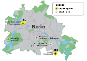
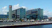
A third, Tempelhof Airport
Tempelhof International Airport
Berlin Tempelhof Airport was an airport in Berlin, Germany, situated in the south-central borough of Tempelhof-Schöneberg. The airport ceased operating in 2008 in the process of establishing Schönefeld as the sole commercial airport for Berlin....
, formerly handled short distance and commuter flights. It was closed at the end of October 2008. A referendum opposing the closure could not gather the required quorum. Closure of Tegel and Tempelhof airports is a legal requirement for the opening of the new Berlin Brandenburg Airport south of the Schönefeld Airport site, in order to alleviate noise pollution throughout the city.
Early aviation
The first airport in Berlin was Johannisthal Air FieldJohannisthal Air Field
The Johannisthal Air Field, located 15 km southeast of Berlin, between Johannisthal and Adlershof, was Germany's first airfield. It opened on 26 September 1909, a few weeks after the world's first airfield at Rheims, France .-Overview:...
which opened on 26 September 1909. Followed shortly after by Staaken Airport around 1915, known for its two zeppelin halls and Deutsche Luft Hansa
Deutsche Luft Hansa
Deutsche Luft Hansa A.G. was a German airline, serving as flag carrier of the country during the later years of the Weimar Republic and throughout the Third Reich.-1920s:Deutsche Luft Hansa was founded on 6 January 1926 in Berlin...
base. Then came Tempelhof Airport in 1923 and Gatow Air Field
RAF Gatow
Known for most of its operational life as Royal Air Force Station Gatow, or more commonly RAF Gatow, this former British Royal Air Force military airbase is in the district of Gatow in south-western Berlin, west of the Havel river, in the borough of Spandau...
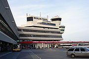
in 1934. Tegel Airport was built during the Berlin Blockade
Berlin Blockade
The Berlin Blockade was one of the first major international crises of the Cold War and the first resulting in casualties. During the multinational occupation of post-World War II Germany, the Soviet Union blocked the Western Allies' railway and road access to the sectors of Berlin under Allied...
in 1948.
Tempelhof was the first airport in the world with regular passenger flights, opening in 1923 with flights to Königsberg (now Kaliningrad
Kaliningrad
Kaliningrad is a seaport and the administrative center of Kaliningrad Oblast, the Russian exclave between Poland and Lithuania on the Baltic Sea...
). Deutsche Luft Hansa
Deutsche Luft Hansa
Deutsche Luft Hansa A.G. was a German airline, serving as flag carrier of the country during the later years of the Weimar Republic and throughout the Third Reich.-1920s:Deutsche Luft Hansa was founded on 6 January 1926 in Berlin...
started its operations from the airport in 1926, while zeppelin
Zeppelin
A Zeppelin is a type of rigid airship pioneered by the German Count Ferdinand von Zeppelin in the early 20th century. It was based on designs he had outlined in 1874 and detailed in 1893. His plans were reviewed by committee in 1894 and patented in the United States on 14 March 1899...
s also frequented the airport. The airport expanded rapidly, becoming one of the largest airports in the world in the 1930s, fittingly provided with enormous halls, which are still visible today, unfinished though they may be. Tempelhof also had another first: it was the first airport to feature its own underground
Rapid transit
A rapid transit, underground, subway, elevated railway, metro or metropolitan railway system is an electric passenger railway in an urban area with a high capacity and frequency, and grade separation from other traffic. Rapid transit systems are typically located either in underground tunnels or on...
station.
After 1945
World War II
World War II, or the Second World War , was a global conflict lasting from 1939 to 1945, involving most of the world's nations—including all of the great powers—eventually forming two opposing military alliances: the Allies and the Axis...
, Tempelhof was used as a U.S. Air Force base, while the Soviet air force
Soviet Air Force
The Soviet Air Force, officially known in Russian as Военно-воздушные силы or Voenno-Vozdushnye Sily and often abbreviated VVS was the official designation of one of the air forces of the Soviet Union. The other was the Soviet Air Defence Forces...
relocated to Schönefeld, outside Berlin, during 1946. The Soviets had reached Tempelhof before the Western Allies. Gatow Air Field
RAF Gatow
Known for most of its operational life as Royal Air Force Station Gatow, or more commonly RAF Gatow, this former British Royal Air Force military airbase is in the district of Gatow in south-western Berlin, west of the Havel river, in the borough of Spandau...
, which was taken over by the RAF in July 1945, was partially outside Berlin. At the Potsdam Conference
Potsdam Conference
The Potsdam Conference was held at Cecilienhof, the home of Crown Prince Wilhelm Hohenzollern, in Potsdam, occupied Germany, from 16 July to 2 August 1945. Participants were the Soviet Union, the United Kingdom, and the United States...
it was then decided to exchange the western half of Staaken
Staaken
Staaken is a locality at the western rim of Berlin within the borough of Spandau. In the west it shares border with the Brandenburg municipalities of Falkensee and Dallgow-Döberitz in the Havelland district. Buildings range from small detached houses in the west to larger 1960s and 1970s housing...
, including Staaken Airport, for the needed territory in Gatow
Gatow
Gatow, a district of south-western Berlin is located west of the Havelsee lake and has forested areas within its boundaries. It is within the borough of Spandau. On 31 December 2002, it had 5,532 inhabitants.-History:...
. Staaken Airport was then used by the Soviet air force
Soviet Air Force
The Soviet Air Force, officially known in Russian as Военно-воздушные силы or Voenno-Vozdushnye Sily and often abbreviated VVS was the official designation of one of the air forces of the Soviet Union. The other was the Soviet Air Defence Forces...
for some time to come.
In April 1948, as a result of growing tension between the Soviet and the Western Allied occupying powers, West Berlin was closed off from the surrounding Soviet sector. Supplies were flown in for over a year; enormous numbers of transport planes flew in and out of Berlin every day of this period. The capacity of the airports then in the three Western sectors was not large enough; to relieve pressure on Gatow and Tempelhof, Tegel Airport was built in the French sector. It was constructed by a labour force mainly consisting of Berlin women, under the supervision of French engineers, within just 90 days. It featured a 2400 m runway
Runway
According to ICAO a runway is a "defined rectangular area on a land aerodrome prepared for the landing and take-off of aircraft." Runways may be a man-made surface or a natural surface .- Orientation and dimensions :Runways are named by a number between 01 and 36, which is generally one tenth...
- the longest in Europe at the time. Because of special Allied bylaws, Lufthansa was not allowed to use Tegel until after German reunification
German reunification
German reunification was the process in 1990 in which the German Democratic Republic joined the Federal Republic of Germany , and when Berlin reunited into a single city, as provided by its then Grundgesetz constitution Article 23. The start of this process is commonly referred by Germans as die...
.
Tempelhof was returned to civil administration in 1951, Schönefeld in 1954 and Tegel in 1960. Gatow Airport remained a military airfield, used by the RAF until 1994 and closed in 1995. Tegel, the newest airport, became the main civilian airport for West Berlin, while Schönefeld served the population of East Berlin
East Berlin
East Berlin was the name given to the eastern part of Berlin between 1949 and 1990. It consisted of the Soviet sector of Berlin that was established in 1945. The American, British and French sectors became West Berlin, a part strongly associated with West Germany but a free city...
. Since the smaller airport at Tempelhof is surrounded by urban development, it could not expand.
Berlin Brandenburg Airport 2012
Following German reunificationGerman reunification
German reunification was the process in 1990 in which the German Democratic Republic joined the Federal Republic of Germany , and when Berlin reunited into a single city, as provided by its then Grundgesetz constitution Article 23. The start of this process is commonly referred by Germans as die...
in 1990, the inefficiency of operating three separate airports became increasingly problematic. Berlin's airport authority (the Berliner Flughafen GmbH, a subsidiary of the Flughafen Berlin-Schönefeld GmbH) will transfer all of Berlin's air traffic to a greatly expanded airport at Schönefeld on 3 June 2012, to be renamed Berlin Brandenburg Airport. One airport would be more efficient and would decrease the noise pollution
Aircraft noise
Aircraft noise is noise pollution produced by any aircraft or its components, during various phases of a flight: on the ground while parked such as auxiliary power units, while taxiing, on run-up from propeller and jet exhaust, during take off, underneath and lateral to departure and arrival paths,...
. The existing airport in Schönefeld will be greatly expanded to the south from its current state to allow this. In fact, the new airport will only have the current southern runway
Runway
According to ICAO a runway is a "defined rectangular area on a land aerodrome prepared for the landing and take-off of aircraft." Runways may be a man-made surface or a natural surface .- Orientation and dimensions :Runways are named by a number between 01 and 36, which is generally one tenth...
(the new designated northern runway) in common with the existing airport.
Berlin Brandenburg Airport will be Germany's third busiest airport upon opening on 3 June 2012, as Berlin's airports served over 22.3 million passengers in 2010. Frankfurt Airport
Frankfurt Airport
Frankfurt Airport may refer to:Airports of Frankfurt, Germany:*Frankfurt Airport , the largest airport in Germany*Frankfurt Egelsbach Airport, a general aviation airport*Frankfurt-Hahn Airport , a converted U.S...
, which served 54 million passengers in 2007, is the country's busiest airport, followed by Munich Airport, which served 34 million passengers in 2007.