

Trans Global Highway
Encyclopedia
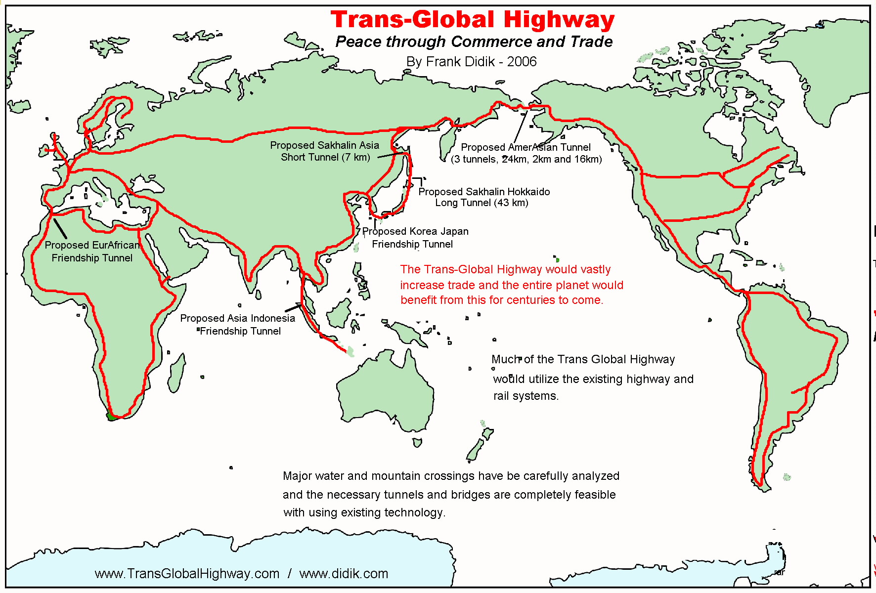
The Trans-Global Highway is a proposed highway system that would link all continents of Earth except Australia and Antarctica. The highway would network new and existing bridges and tunnels, improving not only ground transportation but also potentially offering a conduit for utility pipelines. It was proposed by Frank X. Didik.
first proposed to connect the continents by land via the Cosmopolitan Railway
. Significant elements of that proposal, such as the English Channel Tunnel
, have been constructed since that era. However, the improvement of the global shipping industry and advent of international air travel has reduced the demand for many intercontinental land connections. Some of the missing links are connected by car ferries
.
with a bridge or tunnel called the Intercontinental Peace Bridge, the TKM-World Link or the AmerAsian Peace Tunnel. This would link the Cape Prince of Wales
, with the Russia
n Cape Dezhnev
. The Bering Strait Tunnel would consist of 3 tunnels connecting Alaska
and Russia by going through two islands (the Little Diomede (USA)
and Big Diomede (Russia)
). The longest single tunnel would be 24 miles (40 km). Since the Bering Sea
at the proposed crossing has a maximum known depth of 170 feet (50 m), the tunnels might be dug with conventional tunnel boring machine
s of the type that was employed in the construction of the Channel Tunnel. The three tunnel proposal is considered by many to be preferable over a bridge due to severe environmental conditions, especially the inescapable winter ice damage.
Each proposed tunnel would be shorter than some current tunnels. The Channel tunnel linking England with mainland Europe is approximately 31.34 miles (50.45 km) long; the ocean tunnel Seikan linking Hokkaidō
with Honshū
in Japan is 33.46 miles (55.86 km) long; and the Swiss Gotthard Base Tunnel
through the Alps
, currently under construction, will be 35.7 miles (59.60 km) long.
To make a bridge or tunnel useful, a road must be built to connect it, despite very difficult terrain and climate. In Alaska a 700 miles (1,100 km) road would be needed, and in Russia a road more than 1,200 miles (2,000 km) long must be constructed.
on Kyūshū
, Japan, to the port city of Pusan in Korea via four islands. The maximum ocean depth in this area is 480 feet (146 m). Similar proposals have been discussed for decades by Korean and Japanese politicians.
to Sakhalin Island (the Sakhalin Hokkaidō Long Tunnel), which would be 25 miles (42 km) long and a second tunnel from Sakhalin
to the Siberian Russia
n mainland (the Sakhalin Tunnel
), which would only be 4.2 miles (7 km) long. Moreover, Sakhalin Island region is a major oil-producing region, and the introduction of a pipeline would add a valuable secondary means of oil transport.
is considered economically infeasible owing to the great distance. Cape York
in northern Queensland is 140 km away from New Guinea
. This is a very long distance compared to existing tunnels or bridges, and the demand for car travel is not so high; as of 2009 there are no car ferries between Australia and Papua New Guinea. Passenger travel is by air only.
There might be more demand for connecting parts of Indonesia
, most importantly the heavily populated island of Java
, which could be connected to the Asian mainland by a crossing
to Sumatra
and from there across the Strait of Malacca
to Singapore
and/or Malaysia.
at the Bab-el-Mandeb
has been proposed. It would span from Djibouti
in the Horn of Africa
, across the strait, to Perim Island, and then to Yemen
, for a total distance of around 18 miles including a suspension bridge spanning over 3 miles.
On February 22, 2008, it was revealed that a company owned by Tarek bin Laden
is planning to build a bridge named Bridge of the Horns across the strait, linking Yemen
with Djibouti
Construction was proposed to begin in 2009. Proposals have not yet been approved by the governments of Djibouti and Yemen.
is a section of land located in the Darién Province
in Panama and the Colombia
n border called the Darién Gap
. It is an 87 kilometres (54.1 mi) stretch of rainforest. The gap has been crossed by adventurers on bicycle, motorcycle, all-terrain vehicle
, and foot, dealing with jungle, swamp, insects, and other hazards.
Some people, groups, indigenous populations, and governments are opposed to completing the Darién portion of the highway. Reasons for opposition include protecting the rain forest, containing the spread of tropical diseases, protecting the livelihood of indigenous peoples in the area, and reducing the spread of drug trafficking and its associated violence from Colombia.
require not only great engineering effort, but also tremendous diplomacy to ensure that costs and benefits would be shared equitably. Other modes of transport, by air and sea, are already available. In addition, geological study must be done to ensure that the local plate tectonics
would be compatible with the proposed tunnels.
Despite the hypothetical benefits of a global transport link, there is currently no publicised reasoning that would justify the massive financial cost of such a proposal.
History
In 1890 William GilpinWilliam Gilpin (governor)
William Gilpin was a 19th century U.S. explorer, politician, land speculator, and futurist writer about the American West. He served as military officer in the United States Army during several wars, accompanied John C. Frémont on his second expedition through the West, and was instrumental in the...
first proposed to connect the continents by land via the Cosmopolitan Railway
Cosmopolitan Railway
The Cosmopolitan Railway was a proposed global railroad network advocated by William Gilpin, formerly the first territorial governor of Colorado , in his 1890 treatise Cosmopolitan Railway: Compacting and Fusing Together All the World's Continents...
. Significant elements of that proposal, such as the English Channel Tunnel
Channel Tunnel
The Channel Tunnel is a undersea rail tunnel linking Folkestone, Kent in the United Kingdom with Coquelles, Pas-de-Calais near Calais in northern France beneath the English Channel at the Strait of Dover. At its lowest point, it is deep...
, have been constructed since that era. However, the improvement of the global shipping industry and advent of international air travel has reduced the demand for many intercontinental land connections. Some of the missing links are connected by car ferries
RORO
Roll-on/roll-off ships are vessels designed to carry wheeled cargo such as automobiles, trucks, semi-trailer trucks, trailers or railroad cars that are driven on and off the ship on their own wheels...
.
Bering Strait bridge or tunnel
One of the major components of the proposal is to span the Bering SeaBering Sea
The Bering Sea is a marginal sea of the Pacific Ocean. It comprises a deep water basin, which then rises through a narrow slope into the shallower water above the continental shelves....
with a bridge or tunnel called the Intercontinental Peace Bridge, the TKM-World Link or the AmerAsian Peace Tunnel. This would link the Cape Prince of Wales
Cape Prince of Wales
Cape Prince of Wales is the westernmost point on the mainland of the Americas.Located on the Seward Peninsula of the U.S. state of Alaska near the city of Wales, Cape Prince of Wales is the terminus of the Continental Divide, marking the division between the Pacific and Arctic coasts, as well as...
, with the Russia
Russia
Russia or , officially known as both Russia and the Russian Federation , is a country in northern Eurasia. It is a federal semi-presidential republic, comprising 83 federal subjects...
n Cape Dezhnev
Cape Dezhnev
Cape Dezhnyov or Cape Dezhnev is a cape that forms the eastmost mainland point of Eurasia. It is located on the Chukchi Peninsula in the very thinly populated Chukotka Autonomous Okrug of Russia. This cape is located between the Bering Sea and the Chukchi Sea, across from Cape Prince of Wales in...
. The Bering Strait Tunnel would consist of 3 tunnels connecting Alaska
Alaska
Alaska is the largest state in the United States by area. It is situated in the northwest extremity of the North American continent, with Canada to the east, the Arctic Ocean to the north, and the Pacific Ocean to the west and south, with Russia further west across the Bering Strait...
and Russia by going through two islands (the Little Diomede (USA)
Diomede Islands
The Diomede Islands , also known in Russia as Gvozdev Islands , consist of two rocky, tuya-like islands:* The U.S. island of Little Diomede or, in its native language, Ignaluk , and* The Russian island of Big Diomede , also known as Imaqliq,...
and Big Diomede (Russia)
Diomede Islands
The Diomede Islands , also known in Russia as Gvozdev Islands , consist of two rocky, tuya-like islands:* The U.S. island of Little Diomede or, in its native language, Ignaluk , and* The Russian island of Big Diomede , also known as Imaqliq,...
). The longest single tunnel would be 24 miles (40 km). Since the Bering Sea
Bering Sea
The Bering Sea is a marginal sea of the Pacific Ocean. It comprises a deep water basin, which then rises through a narrow slope into the shallower water above the continental shelves....
at the proposed crossing has a maximum known depth of 170 feet (50 m), the tunnels might be dug with conventional tunnel boring machine
Tunnel boring machine
A tunnel boring machine also known as a "mole", is a machine used to excavate tunnels with a circular cross section through a variety of soil and rock strata. They can bore through anything from hard rock to sand. Tunnel diameters can range from a metre to almost 16 metres to date...
s of the type that was employed in the construction of the Channel Tunnel. The three tunnel proposal is considered by many to be preferable over a bridge due to severe environmental conditions, especially the inescapable winter ice damage.
Each proposed tunnel would be shorter than some current tunnels. The Channel tunnel linking England with mainland Europe is approximately 31.34 miles (50.45 km) long; the ocean tunnel Seikan linking Hokkaidō
Hokkaido
, formerly known as Ezo, Yezo, Yeso, or Yesso, is Japan's second largest island; it is also the largest and northernmost of Japan's 47 prefectural-level subdivisions. The Tsugaru Strait separates Hokkaido from Honshu, although the two islands are connected by the underwater railway Seikan Tunnel...
with Honshū
Honshu
is the largest island of Japan. The nation's main island, it is south of Hokkaido across the Tsugaru Strait, north of Shikoku across the Inland Sea, and northeast of Kyushu across the Kanmon Strait...
in Japan is 33.46 miles (55.86 km) long; and the Swiss Gotthard Base Tunnel
Gotthard Base Tunnel
The Gotthard Base Tunnel is a new railway tunnel beneath the Swiss Alps, expected to open in 2016. With a route length of and a total of of tunnels, shafts and passages, it is the world's longest rail tunnel, surpassing the Japanese Seikan Tunnel....
through the Alps
Alps
The Alps is one of the great mountain range systems of Europe, stretching from Austria and Slovenia in the east through Italy, Switzerland, Liechtenstein and Germany to France in the west....
, currently under construction, will be 35.7 miles (59.60 km) long.
To make a bridge or tunnel useful, a road must be built to connect it, despite very difficult terrain and climate. In Alaska a 700 miles (1,100 km) road would be needed, and in Russia a road more than 1,200 miles (2,000 km) long must be constructed.
Japan Korea Tunnel
Japan might technically be connected with mainland Asia via five tunnels, called the "Korea Japan Friendship Tunnel System," extending from the city of FukuokaFukuoka, Fukuoka
is the capital city of Fukuoka Prefecture and is situated on the northern shore of the island of Kyushu in Japan.Voted number 14 in a 2010 poll of the World's Most Livable Cities, Fukuoka is praised for its green spaces in a metropolitan setting. It is the most populous city in Kyushu, followed by...
on Kyūshū
Kyushu
is the third largest island of Japan and most southwesterly of its four main islands. Its alternate ancient names include , , and . The historical regional name is referred to Kyushu and its surrounding islands....
, Japan, to the port city of Pusan in Korea via four islands. The maximum ocean depth in this area is 480 feet (146 m). Similar proposals have been discussed for decades by Korean and Japanese politicians.
Hokkaidō Sakhalin Asia Tunnel
It may also be possible to connect Japan to mainland Asia by constructing two tunnels extending north from HokkaidōHokkaido
, formerly known as Ezo, Yezo, Yeso, or Yesso, is Japan's second largest island; it is also the largest and northernmost of Japan's 47 prefectural-level subdivisions. The Tsugaru Strait separates Hokkaido from Honshu, although the two islands are connected by the underwater railway Seikan Tunnel...
to Sakhalin Island (the Sakhalin Hokkaidō Long Tunnel), which would be 25 miles (42 km) long and a second tunnel from Sakhalin
Sakhalin
Sakhalin or Saghalien, is a large island in the North Pacific, lying between 45°50' and 54°24' N.It is part of Russia, and is Russia's largest island, and is administered as part of Sakhalin Oblast...
to the Siberian Russia
Russia
Russia or , officially known as both Russia and the Russian Federation , is a country in northern Eurasia. It is a federal semi-presidential republic, comprising 83 federal subjects...
n mainland (the Sakhalin Tunnel
Sakhalin Tunnel
The Sakhalin Tunnel is an incomplete and currently postponed construction project, which after completion would connect the island of Sakhalin with mainland Russia via a tunnel of approximately 10 km under the Nevelskoy Strait...
), which would only be 4.2 miles (7 km) long. Moreover, Sakhalin Island region is a major oil-producing region, and the introduction of a pipeline would add a valuable secondary means of oil transport.
Gibraltar Tunnel
The Gibraltar Tunnel is proposed to be a rail tunnel linking Africa and Europe. Due to the depth of the Strait of Gibraltar (300–900 metres / 1000–2950 feet), it would be a great challenge to remove automobile exhaust from this depth. Any tunnel would most likely be an electrified rail tunnel, similar to the Channel Tunnel linking the UK and France. There have also been proposals for a bridge over the Strait.Australia-Papua New Guinea Tunnel and Connections to Indonesia
A tunnel/bridge between the Australian mainland and the island of New GuineaNew Guinea
New Guinea is the world's second largest island, after Greenland, covering a land area of 786,000 km2. Located in the southwest Pacific Ocean, it lies geographically to the east of the Malay Archipelago, with which it is sometimes included as part of a greater Indo-Australian Archipelago...
is considered economically infeasible owing to the great distance. Cape York
Cape York Peninsula
Cape York Peninsula is a large remote peninsula located in Far North Queensland at the tip of the state of Queensland, Australia, the largest unspoilt wilderness in northern Australia and one of the last remaining wilderness areas on Earth...
in northern Queensland is 140 km away from New Guinea
New Guinea
New Guinea is the world's second largest island, after Greenland, covering a land area of 786,000 km2. Located in the southwest Pacific Ocean, it lies geographically to the east of the Malay Archipelago, with which it is sometimes included as part of a greater Indo-Australian Archipelago...
. This is a very long distance compared to existing tunnels or bridges, and the demand for car travel is not so high; as of 2009 there are no car ferries between Australia and Papua New Guinea. Passenger travel is by air only.
There might be more demand for connecting parts of Indonesia
Indonesia
Indonesia , officially the Republic of Indonesia , is a country in Southeast Asia and Oceania. Indonesia is an archipelago comprising approximately 13,000 islands. It has 33 provinces with over 238 million people, and is the world's fourth most populous country. Indonesia is a republic, with an...
, most importantly the heavily populated island of Java
Java
Java is an island of Indonesia. With a population of 135 million , it is the world's most populous island, and one of the most densely populated regions in the world. It is home to 60% of Indonesia's population. The Indonesian capital city, Jakarta, is in west Java...
, which could be connected to the Asian mainland by a crossing
Sunda Strait Bridge
The Sunda Strait Bridge is a planned road and railway megaproject between the two Indonesian islands of Sumatra and Java...
to Sumatra
Sumatra
Sumatra is an island in western Indonesia, westernmost of the Sunda Islands. It is the largest island entirely in Indonesia , and the sixth largest island in the world at 473,481 km2 with a population of 50,365,538...
and from there across the Strait of Malacca
Strait of Malacca
The Strait of Malacca is a narrow, stretch of water between the Malay Peninsula and the Indonesian island of Sumatra. It is named after the Malacca Sultanate that ruled over the archipelago between 1414 to 1511.-Extent:...
to Singapore
Singapore
Singapore , officially the Republic of Singapore, is a Southeast Asian city-state off the southern tip of the Malay Peninsula, north of the equator. An island country made up of 63 islands, it is separated from Malaysia by the Straits of Johor to its north and from Indonesia's Riau Islands by the...
and/or Malaysia.
Red Sea
A bridge spanning the Red SeaRed Sea
The Red Sea is a seawater inlet of the Indian Ocean, lying between Africa and Asia. The connection to the ocean is in the south through the Bab el Mandeb strait and the Gulf of Aden. In the north, there is the Sinai Peninsula, the Gulf of Aqaba, and the Gulf of Suez...
at the Bab-el-Mandeb
Bab-el-Mandeb
The Bab-el-Mandeb meaning "Gate of Grief" in Arabic , is a strait located between Yemen on the Arabian Peninsula, Djibouti and Eritrea, north of Somalia, in the Horn of Africa, and connecting the Red Sea to the Gulf of Aden...
has been proposed. It would span from Djibouti
Djibouti
Djibouti , officially the Republic of Djibouti , is a country in the Horn of Africa. It is bordered by Eritrea in the north, Ethiopia in the west and south, and Somalia in the southeast. The remainder of the border is formed by the Red Sea and the Gulf of Aden at the east...
in the Horn of Africa
Horn of Africa
The Horn of Africa is a peninsula in East Africa that juts hundreds of kilometers into the Arabian Sea and lies along the southern side of the Gulf of Aden. It is the easternmost projection of the African continent...
, across the strait, to Perim Island, and then to Yemen
Yemen
The Republic of Yemen , commonly known as Yemen , is a country located in the Middle East, occupying the southwestern to southern end of the Arabian Peninsula. It is bordered by Saudi Arabia to the north, the Red Sea to the west, and Oman to the east....
, for a total distance of around 18 miles including a suspension bridge spanning over 3 miles.
On February 22, 2008, it was revealed that a company owned by Tarek bin Laden
Tarek bin Laden
Tarek bin Mohammed bin 'Awad bin Laden, is a half-brother of Osama bin Laden, and a noted member of the Saudi-Arabia business community....
is planning to build a bridge named Bridge of the Horns across the strait, linking Yemen
Yemen
The Republic of Yemen , commonly known as Yemen , is a country located in the Middle East, occupying the southwestern to southern end of the Arabian Peninsula. It is bordered by Saudi Arabia to the north, the Red Sea to the west, and Oman to the east....
with Djibouti
Djibouti
Djibouti , officially the Republic of Djibouti , is a country in the Horn of Africa. It is bordered by Eritrea in the north, Ethiopia in the west and south, and Somalia in the southeast. The remainder of the border is formed by the Red Sea and the Gulf of Aden at the east...
Construction was proposed to begin in 2009. Proposals have not yet been approved by the governments of Djibouti and Yemen.
English Channel
There is no highway connection between Great Britain and the European mainland; only a railway connection, the Channel tunnel. A road tunnel was proposed as an alternative, but not considered viable.Darién Gap
A notable break in the Pan-American HighwayPan-American Highway
The Pan-American Highway is a network of roads measuring about in total length. Except for an rainforest break, called the Darién Gap, the road links the mainland nations of the Americas in a connected highway system. According to Guinness World Records, the Pan-American Highway is the world's...
is a section of land located in the Darién Province
Darién Province
Darién is a province in eastern Panama. It is also the largest province in Panama. It is hot, humid, heavily forested, and sparsely populated, having 48,378 habitants...
in Panama and the Colombia
Colombia
Colombia, officially the Republic of Colombia , is a unitary constitutional republic comprising thirty-two departments. The country is located in northwestern South America, bordered to the east by Venezuela and Brazil; to the south by Ecuador and Peru; to the north by the Caribbean Sea; to the...
n border called the Darién Gap
Darién Gap
The Darién Gap is a large swath of undeveloped swampland and forest separating Panama's Darién Province in Central America from Colombia in South America. It measures just over long and about wide. Roadbuilding through this area is expensive, and the environmental toll is steep. Political...
. It is an 87 kilometres (54.1 mi) stretch of rainforest. The gap has been crossed by adventurers on bicycle, motorcycle, all-terrain vehicle
All-terrain vehicle
An all-terrain vehicle , also known as a quad, quad bike, three wheeler, or four wheeler, is defined by the American National Standards Institute as a vehicle that travels on low pressure tires, with a seat that is straddled by the operator, along with handlebars for steering control...
, and foot, dealing with jungle, swamp, insects, and other hazards.
Some people, groups, indigenous populations, and governments are opposed to completing the Darién portion of the highway. Reasons for opposition include protecting the rain forest, containing the spread of tropical diseases, protecting the livelihood of indigenous peoples in the area, and reducing the spread of drug trafficking and its associated violence from Colombia.
Difficulties
As with all major public works projects, funding is an issue. Large international projects such as the Bering Strait crossing, Japan–Korea Undersea Tunnel, and Strait of Gibraltar crossingStrait of Gibraltar crossing
A Strait of Gibraltar crossing is a hypothetical bridge or tunnel spanning the Strait of Gibraltar that would connect Europe to Africa.The Spanish and Moroccan governments appointed a a to investigate the feasibility of linking the two continents...
require not only great engineering effort, but also tremendous diplomacy to ensure that costs and benefits would be shared equitably. Other modes of transport, by air and sea, are already available. In addition, geological study must be done to ensure that the local plate tectonics
Plate tectonics
Plate tectonics is a scientific theory that describes the large scale motions of Earth's lithosphere...
would be compatible with the proposed tunnels.
Despite the hypothetical benefits of a global transport link, there is currently no publicised reasoning that would justify the massive financial cost of such a proposal.
See also
- Cosmopolitan RailwayCosmopolitan RailwayThe Cosmopolitan Railway was a proposed global railroad network advocated by William Gilpin, formerly the first territorial governor of Colorado , in his 1890 treatise Cosmopolitan Railway: Compacting and Fusing Together All the World's Continents...
- Trans-Asian RailwayTrans-Asian RailwayThe Trans-Asian Railway is a project to create an integrated freight railway network across Europe and Asia. The TAR is a project of the United Nations Economic and Social Commission for Asia and the Pacific .- Overview :...
- AtlantropaAtlantropaAtlantropa, also referred to as Panropa, was a gigantic engineering and colonization project devised by the German architect Herman Sörgel in the 1920s and promulgated by him until his death in 1952...
- Pan-American HighwayPan-American HighwayThe Pan-American Highway is a network of roads measuring about in total length. Except for an rainforest break, called the Darién Gap, the road links the mainland nations of the Americas in a connected highway system. According to Guinness World Records, the Pan-American Highway is the world's...
- Transatlantic tunnelTransatlantic tunnelA transatlantic tunnel is a theoretical tunnel which would span the Atlantic Ocean between North America and Europe and would carry mass transit of some type—trains are envisioned in most proposals.Using advanced technologies, speeds of are envisaged....
- Strait of Messina BridgeStrait of Messina BridgeThe Strait of Messina Bridge is a long-planned suspension bridge across the Strait of Messina, a narrow section of water between the eastern tip of Sicily and the southern tip of mainland Italy. In 2006, under Prime Minister Romano Prodi the project was cancelled...