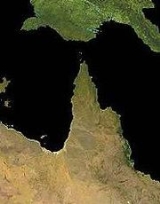
All Topics  
Cape York Peninsula

 
Cape York Peninsula

   Email Print
   Bookmark   Link


Cape York Peninsula


Cape York Peninsula is a large peninsula
Peninsula

A peninsula is a piece of Landform that is nearly surrounded by water but connected to mainland via an isthmus. Word origin: Latin paeninsula : paene, almost + insula, island....
 located in Far North
Far North Queensland

Far North Queensland, or FNQ, is the northernmost part of the Australian States and territories of Australia of Queensland. The region, which contains a large section of the Tropical North Queensland area, stretches from the city of Cairns, Queensland north to the Torres Strait....
 Queensland
Queensland

Queensland is a States and territories of Australia of Australia, occupying the north-eastern section of the mainland continent. It is bordered by the Northern Territory to the west, South Australia to the south-west and New South Wales to the south....
, Australia
Australia

Australia, officially the Commonwealth of Australia, is a country in the southern hemisphere comprising the Australia of the world's smallest continent, the major island of Tasmania, and numerous list of islands of Australia in the Indian Ocean and Pacific Oceans....
. This remote peninsula is one of the last remaining wilderness areas on Earth. Its undisturbed tropical rainforests and savannas are now recognized for their global environmental significance.


Discussion
Ask a question about 'Cape York Peninsula'
Start a new discussion about 'Cape York Peninsula'
Answer questions from other users
Full Discussion Forum


Encyclopedia


Cape York Peninsula
Cape York Peninsula is a large peninsula
Peninsula

A peninsula is a piece of Landform that is nearly surrounded by water but connected to mainland via an isthmus. Word origin: Latin paeninsula : paene, almost + insula, island....
 located in Far North
Far North Queensland

Far North Queensland, or FNQ, is the northernmost part of the Australian States and territories of Australia of Queensland. The region, which contains a large section of the Tropical North Queensland area, stretches from the city of Cairns, Queensland north to the Torres Strait....
 Queensland
Queensland

Queensland is a States and territories of Australia of Australia, occupying the north-eastern section of the mainland continent. It is bordered by the Northern Territory to the west, South Australia to the south-west and New South Wales to the south....
, Australia
Australia

Australia, officially the Commonwealth of Australia, is a country in the southern hemisphere comprising the Australia of the world's smallest continent, the major island of Tasmania, and numerous list of islands of Australia in the Indian Ocean and Pacific Oceans....
. This remote peninsula is one of the last remaining wilderness areas on Earth. Its undisturbed tropical rainforests and savannas are now recognized for their global environmental significance. A nomination for World Natural Heritage
World Heritage Site

A UNESCO World Heritage Site is a site that is on the list maintained by the international World Heritage Programme administered by the UNESCO World Heritage Committee, composed of 21 Sovereign state which are elected by their General Assembly for a four-year term....
 is currently being considered by the Queensland and Australian Federal governments.

The Cape York Peninsula region encompasses an area of approximately 137,000 km² north of 16°S latitude. It has a population of only about 18,000, of which a large percentage (~60 %) are Aborigines
Indigenous Australians

Indigenous Australians are the first human inhabitants of the Australian continent and its nearby islands and their descendants. Indigenous Australians are distinguished as either Australian Aborigines or Torres Strait Islanders, who currently together make up about 2.6% of Australia's population....
 and Torres Strait Islanders
Torres Strait Islanders

Torres Strait Islanders are the indigenous peoples of the Torres Strait Islands, part of Queensland, Australia. They are culturally akin to the coastal peoples of Papua New Guinea....
.

At the tip of the peninsula lies Cape York, the northernmost point on the Australian continent
Continent

A continent is one of several large landmasses on Earth. They are generally identified by convention rather than any strict criteria, with seven regions commonly regarded as continents ? they are : Asia, Africa, North America, South America, Antarctica, Europe, and Australia ....
. It was named by Lt. James Cook
James Cook

Captain James Cook Royal Society Royal Navy was an English explorer, navigator and cartographer, ultimately rising to the rank of Captain in the Royal Navy....
 in 1770 after His Royal Highness the Duke of York. From the tip, it is about 160 km to New Guinea
New Guinea

New Guinea, located just north of Australia, is the List of islands by area, having become separated from the Australian mainland when the area now known as the Torres Strait flooded after the last glacial period....
 across the island-studded Torres Strait
Torres Strait

The Torres Strait is a body of water which lies between Australia and the Melanesian island of New Guinea. It is approximately 150 kilometre wide at its narrowest extent....
. The west coast borders the Gulf of Carpentaria
Gulf of Carpentaria

File:Gulf of Carpentaria map.pngFile:Gulf-of-Carpentaria-Australia-Otto-Petri-1859-Rotterdam.jpgThe Gulf of Carpentaria is a large, shallow sea enclosed on three sides by northern Australia and bounded on the north by the Arafura Sea ....
 and the east coast borders the Coral Sea
Coral Sea

The Coral Sea is a marginal sea off the north-east coast of Australia. It is bounded in the west by the east coast of Queensland, thereby including the Great Barrier Reef, in the east by Vanuatu and by New Caledonia, and in the north approximately by the southern extremity of the Solomon Islands....
.

Geography and geology

As a peninsula
Peninsula

A peninsula is a piece of Landform that is nearly surrounded by water but connected to mainland via an isthmus. Word origin: Latin paeninsula : paene, almost + insula, island....
, Cape York is bordered on three sides (north, east and west) by water. There is no clear demarcation to the south. The official boundary of the Cape York Peninsula Region as referred to in the Cape York Peninsula Heritage Act 2007 of Queensland runs along approximately 16°S latitude. The entire region covers an area of approximately 137,000 km². At the peninsula’s widest points, it is 430 km from the Bloomfield River, in the southeast, across to the west coast (just south of Kowanyama
Kowanyama, Queensland

Kowanyama is a town on the Gulf of Carpentaria side of Cape York Peninsula in Far North Queensland, Australia.At the 2006 Census in Australia, Kowanyama had a population of 1,017....
), and some 660 km from the southern border of Cook Shire, to the tip of Cape York.

Geological history

Around 40 million years ago, the Indo-Australian tectonic plate
Indo-Australian Plate

The Indo-Australian Plate is a major tectonic plate that includes the Australia and surrounding ocean, and extends northwest to include the Indian subcontinent and adjacent waters....
 began to split apart from the ancient supercontinent
Supercontinent

In geology, a supercontinent is a landmass comprising more than one continental core, or craton. The assembly of cratons and terrane that form Eurasia qualifies as a supercontinent today....
 Gondwana
Gondwana

Gondwana , originally Gondwanaland is the name given to a southern precursor-supercontinent and then as a remnant separated from Laurasia 180- during the breakup of the Pangaea supercontinent that existed about 500 to 200 Annum ago into two large segments.
. As it collided with the Pacific Plate
Pacific Plate

The Pacific Plate is an oceanic tectonic plate beneath the Pacific Ocean.To the north the easterly side is a divergent boundary with the Explorer Plate, the Juan de Fuca Plate and the Gorda Plate forming respectively the Explorer Ridge, the Juan de Fuca Ridge and the Gorda Ridge....
 on its northward journey, the high mountain ranges of central New Guinea
New Guinea

New Guinea, located just north of Australia, is the List of islands by area, having become separated from the Australian mainland when the area now known as the Torres Strait flooded after the last glacial period....
 emerged around 5 million years ago. In the lee of this collision zone, the ancient rock formations of what is now Cape York peninsula remained largely undisturbed.

Throughout the Pleistocene
Pleistocene

The Pleistocene is the epoch from 1.8 million to 10,000 years Before Present covering the world's recent period of repeated glaciations. The name pleistocene is derived from the Greek and ....
 epoch Australia and New Guinea have been alternately land-linked and separated by water on a number of occasions. During periods of glaciation
Glacier

A glacier is a large, slow-moving mass of ice, formed from compacted layers of snow, that slowly deforms and flows in response to gravity and high pressure....
 and resulting low sea levels, Cape York Peninsula provided a low-lying land link
Land bridge

A land bridge, in biogeography, is an isthmus or wider land connection between otherwise separate areas, which allows terrestrial animals and plants to cross over and colonise new lands....
. Another link existed between Arnhem Land
Arnhem Land

The Arnhem Land Region is one of the five regions of the Northern Territory of Australia. It is located in the north-eastern corner of the territory and is around 500km from the territory capital Darwin, Northern Territory....
 and New Guinea
New Guinea

New Guinea, located just north of Australia, is the List of islands by area, having become separated from the Australian mainland when the area now known as the Torres Strait flooded after the last glacial period....
, at times enclosing an enormous freshwater lake (Lake Carpentaria) in the centre of what is now the Gulf of Carpentaria
Gulf of Carpentaria

File:Gulf of Carpentaria map.pngFile:Gulf-of-Carpentaria-Australia-Otto-Petri-1859-Rotterdam.jpgThe Gulf of Carpentaria is a large, shallow sea enclosed on three sides by northern Australia and bounded on the north by the Arafura Sea ....
. In this way, Australia and New Guinea remained connected until the shallow Torres Strait
Torres Strait

The Torres Strait is a body of water which lies between Australia and the Melanesian island of New Guinea. It is approximately 150 kilometre wide at its narrowest extent....
 was last flooded around 8,000 years ago.

Landforms

The tropical landscapes of Cape York are among the most stable in the world. Long undisturbed by tectonic activity, Cape York is an extremely eroded, almost level plain, with some very low hills on the eastern side.

The backbone of Cape York is the Peninsula Ridge, part of Australia’s Great Dividing Range
Great Dividing Range

The Great Dividing Range, or the Eastern Highlands, is Australia's most substantial mountain range and the 4th longest in the world. The range stretches more than 3,500 km from Dauan_Island,_Queensland off the northeastern tip of Queensland, running the entire length of the eastern coastline through New South Wales, then into Victoria...
. This mountain range
Mountain range

A mountain range is a chain of mountains bordered by highlands or separated from other mountains by mountain pass or valleys. Individual mountains within the same mountain range do not necessarily have the same geology, though they often do; they may be a mix of different orogeny, for example volcanoes, uplifted mountains or Fold mountains...
 is made up of ancient (1,500 million year-old) Precambrian
Precambrian

The Precambrian is an informal name for the supereon comprising the eon of the geologic timescale that came before the current Phanerozoic eon....
 and Palaeozoic rocks and rises to some 800m elevation in the McIlwraith Range
McIlwraith Range

The McIlwraith Range is a rugged, dissected granite plateau on the Cape York Peninsula, Far North Queensland, Australia. Part of the Great Dividing Range, it covers about 3000 square kilometre and lies about 15 km east of the town of Coen, Queensland, and 550 km north of Cairns, Queensland....
 around Coen
Coen

Coen may refer to:* Coen brothers, filmmakers* Coen, Queensland* Jan Pieterszoon Coen, Governor-General of the Dutch East Indies...
. To the East and West of the Peninsula Ridge lie the Carpentaria and Laura Basins, themselves made up of ancient Mesozoic
Mesozoic

The Mesozoic Era is one of three Geologic time scale of the Phanerozoic eon . The division of time into eras dates back to Giovanni Arduino, in the 18th century, although his original name for the era now called the 'Mesozoic' was 'Secondary' ....
 sediments. Those lowlands are dominated by mighty meandering
Meander

A meander in general is a bend in a sinuosity watercourse, also known as an oxbow loop, or simply an oxbow. A meander is formed when the moving water in a river erodes the outer banks and widens its valley creating a meander....
 river
River

A river is a natural stream of water, usually freshwater, flowing toward an ocean, a lake, or another stream. In some cases a river flows into the ground or dries up completely before reaching another body of water....
s and vast floodplain
Floodplain

||-||-||-||-||-||-||-||}A floodplain, or flood plain, is flat or nearly flat land adjacent to a stream or river that experiences occasional or periodic flooding....
s.

There are also several outstanding landforms on the Cape York Peninsula: the large expanses of undisturbed dunefields
Dune

In physical geography, a dune is a hill of sand built by aeolian processes. Dunes are subject to different forms and sizes based on their interaction with the wind....
 at the eastern coast around Shelburne Bay and Cape Bedford-Cape Flattery; the huge piles of black granite boulders at Black Mountain National Park
Black Mountain National Park

Black Mountain National Park is a 600 hectare protected area in the Queensland, , 25 km south west of Cooktown, Queensland, managed and protected as a National Park under the Nature Conservation Act 1992
 and Cape Melville
Cape Melville

Cape Melville is a Headlands and bays on the eastern coast of the Cape York Peninsula. To its west lies Princess Charlotte Bay....
; or the limestone karsts around Palmerston in the Cape’s far south.

Rivers

The Peninsula Ridge forms the drainage divide between the Gulf of Carpentaria
Gulf of Carpentaria

File:Gulf of Carpentaria map.pngFile:Gulf-of-Carpentaria-Australia-Otto-Petri-1859-Rotterdam.jpgThe Gulf of Carpentaria is a large, shallow sea enclosed on three sides by northern Australia and bounded on the north by the Arafura Sea ....
 and the Coral Sea. To the west, a series of large, winding river systems including the Mitchell
Mitchell River (Queensland)

The Mitchell River is a river in the Far North Queensland region of Australia. The river begins on the Atherton Tableland about northwest of Cairns, Queensland, and flows about northwest across Cape York Peninsula from Mareeba, Queensland to the Gulf of Carpentaria....
, Coleman, Holroyd, Archer, Watson, Wenlock, Ducie and Jardine
Jardine River

The Jardine River is the largest river of Australia's Cape York Peninsula and is named after the pioneer Frank Jardine..References...
 catchments empty their waters into the Gulf of Carpentaria. During the Dry season
Dry season

The dry season is a term commonly used when describing the weather in the tropics. The weather in the tropics is dominated by the tropical rain belt, which oscillation from the northern to the southern tropics over the course of the year....
, those rivers are reduced to a series of waterholes and sandy beds. Yet, with the arrival of torrential rains in the Wet season
Wet season

Rainy season is the time of year, covering one or more months, when most of the average annual rainfall in a region falls. The term green season is also sometimes used as a euphemism by tourist authorities....
, they swell to mighty waterways, spreading across extensive floodplains and coastal wetlands and giving life to a vast array of freshwater and wetland species.

On the Eastern slopes, the shorter, faster-flowing Jacky Jacky Creek, Olive, Pascoe, Lockhart, Stewart, Jeannie and Endeavour
Endeavour River

The Endeavour River on Cape York Peninsula in Far North Queensland, Australia, was named in 1770 by Lt. James Cook, R.N., after he was forced to beach his ship HM Bark Endeavour, after damaging it on a reef, for repairs in the river mouth....
 Rivers flow towards the Coral Sea, providing important freshwater and nutrients to the healthiest section of the Great Barrier Reef
Great Barrier Reef

The Great Barrier Reef is the largest coral reef system in the world, composed of over 2,900 individual reefs and 900 islands stretching for 2,600 kilometres over an area of approximately ....
. On their way, those wild, undisturbed rivers
Wild River

Wild River is a 1960 film directed by Elia Kazan starring Montgomery Clift, Lee Remick, Jo Van Fleet, Albert Salmi and Jay C. Flippen filmed on location in the Tennessee Valley....
 are lined with dense rainforests, sand dunes or mangroves.

The floodplains of the Laura Basin, which are protected in the Lakefield
Lakefield National Park

Lakefield is a National Park in Queensland , 1,707 km northwest of Brisbane. It is the second largest park in Queensland and a favourite place for fishing and camping....
 and Jack River National Parks, are crossed by the Morehead, Hann, North Kennedy, Laura, Jack and Normanby
Normanby River

The Normanby River is a major river in northern Queensland, located on the edge of the Wet Tropics and flowing in a generally north-northwestward direction through seasonally flooded savanna grassland to Princess Charlotte Bay about 150 kilometres from Cooktown....
 Rivers.

Cape York’s river catchments are noted for their exceptional hydrological
Hydrology

Hydrology is the study of the movement, distribution, and quality of water throughout the Earth, and thus addresses both the hydrologic cycle and water resources....
 integrity. With little disturbance on both water flows and vegetation cover throughout entire catchments, Cape York has been identified as one of the few places where tropical water cycles
Water cycle

The water cycle, also known as the hydrologic cycle, describes the continuous movement of water on, above, and below the surface of the Earth....
 remain essentially intact. Cape York Peninsula contributes as much as a quarter of Australia's surface runoff
Surface runoff

Surface runoff is the water flow which occurs when soil is infiltrated to full capacity and excess water, from rain, snowmelt, or other sources flows over the land....
. Indeed, with only about 2.7 percent of Australia's land area it produces more runoff than all of Australia south of the Tropic of Capricorn
Tropic of Capricorn

The Tropic of Capricorn, or Southern tropic, is one of the five major circle of latitude that mark maps of the Earth. It lies 23degree 26' 22? south of the Equator, and marks the most southerly latitude at which the sun can appear directly overhead at noon....
. Tapping those heavy tropical rainfalls, Cape York’s rivers are also of particular importance for replenishing central Australia’s Great Artesian Basin
Great Artesian Basin

The Great Artesian Basin provides the only reliable source of water through much of inland Australia. The basin is the largest and deepest Artesian aquifer in the world, covering a total of ....
. The Queensland Government is currently poised to protect 13 of Cape York’s wild rivers under the Wild Rivers Act 2005.

Soils

The soil
Soil

Soil is the naturally occurring, unconsolidated or loose covering on the Earth's surface. Soil is composed of particles of broken rock that have been altered by chemical and environmental processes including weathering and erosion....
s on Cape York are remarkably infertile even compared to other areas of Australia, being almost entirely laterised
Laterite

Laterite is a surface formation in hot and wet tropical areas which is enriched in iron and aluminium and develops by intensive and long lasting weathering of the underlying parent rock....
  and in most cases so old and weathered that very little development is apparent today (classified in USDA soil taxonomy
USDA soil taxonomy

USDA Soil Taxonomy developed by United States Department of Agriculture and the National Cooperative Soil Survey provides an elaborate Soil classification of soil types according to several parameters and in several levels: Order, Suborder, Great Group, Subgroup, Family, and Soil series....
 as Orthent
Orthent

In USDA soil taxonomy, Orthents are defined as Entisols that lack horizon development due to either steep slopes or parent materials that contain no permanent weatherable minerals ....
s). It is because of this extraordinary soil poverty that the region is so thinly settled: the soils are so unworkable and unresponsive to fertilisation that attempts to grow commercial crops have usually failed.

Climate

The climate on Cape York Peninsula is tropical and monsoon
Monsoon

A monsoon is a seasonal prevailing wind that lasts for several months. The term was first used in English in India, Bangladesh, Pakistan, and neighboring countries to refer to the big seasonal winds blowing from the Indian Ocean and Arabian Sea in the southwest bringing heavy rainfall to the region....
al, with a wet season extending from November to April and a dry season from May to October. The temperature across it is warm to hot, with a cooler climate in higher areas. The mean annual temperatures range from 18 °C
Celsius

Celsius is a temperature scale that is named after the Swedish astronomer Anders Celsius , who developed a similar temperature scale two years before his death....
 at higher elevations to 27 °C
Celsius

Celsius is a temperature scale that is named after the Swedish astronomer Anders Celsius , who developed a similar temperature scale two years before his death....
 on the lowlands in the far south-west. Temperatures over 40 °C
Celsius

Celsius is a temperature scale that is named after the Swedish astronomer Anders Celsius , who developed a similar temperature scale two years before his death....
 and below 5 °C
Celsius

Celsius is a temperature scale that is named after the Swedish astronomer Anders Celsius , who developed a similar temperature scale two years before his death....
 are rare.

Annual rainfall is high, ranging from over 2000 mm. in the Iron Range and north of Weipa to about 700 mm. at the southern border. Almost all this rain falls between November and April, and only on the eastern slopes of the Iron Range is the median
Median

In probability theory and statistics, a median is described as the number separating the higher half of a sample, a population, or a probability distribution, from the lower half....
 rainfall between June and September above 5mm (0.2 inches). Between January and March, however, the median monthly rainfall ranges from about 170mm (6.5 inches) in the south to over 500mm (20 inches) in the north and on the Iron Range.

Ecology and biology


Ecosystems

Cape York Peninsula supports a complex mosaic of intact tropical rainforests, tropical savannas
Tropical and subtropical grasslands, savannas, and shrublands

Tropical and subtropical grasslands, savannas, and shrublands are a grassland biome located in semi-arid to semi-humid climate regions of subtropical and tropical latitudes....
, heathlands
Heath (habitat)

A heath or heathland is a Chamaephyte habitat found on mainly infertile acidic soils, characterised by open, low growing woody vegetation, often Dominance by plants of the Ericaceae....
, wetlands, wild rivers
Wild Rivers

Wild Rivers is a waterpark in Irvine, California, California. Its flagship rides include Patriot and Bazooka Bowls. Wild Rivers has over 40 rides and attractions and is open from mid-May to September....
 and mangrove
Mangrove

Mangroves are trees and shrubs that grow in saline water coastal habitats in the tropics and subtropics. The word is used in at least three senses: most broadly to refer to the habitat and entire plant assemblage or mangal, for which the terms mangrove swamp and mangrove forest are also used, to refer to all trees and...
 swamps. Almost the entire area of Cape York (99.6%) still retains its native vegetation and is little fragmented. Therefore, the Peninsula has also been noted for its exceptionally high wilderness quality.

The majority of Cape York is covered in tropical savannas
Tropical and subtropical grasslands, savannas, and shrublands

Tropical and subtropical grasslands, savannas, and shrublands are a grassland biome located in semi-arid to semi-humid climate regions of subtropical and tropical latitudes....
. On Cape York, this ecosystem consists typically of a tall dense grass layer and varying densities of trees (dominantly eucalypt
Eucalypt

Eucalypts are woody plants belonging to three closely related genera:Eucalyptus, Corymbia and Angophora.In 1995 new evidence, largely genetic, indicated that some prominent Eucalyptus species were actually more closely related to Angophora than to the other eucalypts; they were split off into the new genus Corymbia....
s), making it a tropical savanna woodland. Although abundant and fully functioning on Cape York, tropical savannas are now rare and highly degraded in other parts of the world.

Cape York’s tropical rainforest
Tropical rainforest

Tropical rainforests are usually found around the equator. They are common in Asia, Australia, Africa, South America, Central America, Southern Mexico and on many of the Pacific Islands....
s cover an area of 748,000 ha, or 5.6 percent of the total land area. Rainforests depend on some level of rainfall throughout the long Dry season
Dry season

The dry season is a term commonly used when describing the weather in the tropics. The weather in the tropics is dominated by the tropical rain belt, which oscillation from the northern to the southern tropics over the course of the year....
, climatic conditions that are mostly found on the eastern slopes of the Cape’s coastal ranges. Being almost exclusively untouched, old-growth forests and supporting a disproportionately high biodiversity, all those forests are of high conservation significance. The largest contiguous rainforest area on the Cape occurs in the McIllwraith Range-Iron Range
Iron Range National Park

Iron Range is a National Park located in Queensland, Australia, 1940 km northwest of Brisbane and 100 km east of Weipa in the Cape York Peninsula, Queensland....
 area. This area contains at least 1000 different plants, including 100 rare or threatened species, supports 16% of Australia's orchid species and 200 species of butterfly including 11 endemic butterflies.

On poor, dry soils tropical heathlands
Heath (habitat)

A heath or heathland is a Chamaephyte habitat found on mainly infertile acidic soils, characterised by open, low growing woody vegetation, often Dominance by plants of the Ericaceae....
 can be found. North-east Cape York supports Australia’s largest areas of this highly diverse ecosystem.

The extensive wetland
Wetland

File:Mangrove trees in Everglades.JPGA wetland is an area of land whose soil is saturated with moisture either permanently or seasonally. Such areas may also be covered partially or completely by shallow pools of water....
s on Cape York Peninsula are “among the largest, richest and most diverse in Australia”. 19 wetlands of national significance have been identified, mostly on the large floodplains and in coastal areas. Important wetlands include the Jardine Complex
Jardine River National Park

The Jardine River National Park is a national park Queensland , 2137 km northwest of Brisbane and about 900 km northwest of Cairns, on the tip of Cape York Peninsula....
, Lakefield
Lakefield National Park

Lakefield is a National Park in Queensland , 1,707 km northwest of Brisbane. It is the second largest park in Queensland and a favourite place for fishing and camping....
, and the estuaries of the great rivers of the western plains. Many of these wetland come into existence only during the Wet season
Wet season

Rainy season is the time of year, covering one or more months, when most of the average annual rainfall in a region falls. The term green season is also sometimes used as a euphemism by tourist authorities....
 and support rare or uncommon plant communities, provide important fish habitat, crocodile habitat and drought refuge.

Cape York’s coastal areas and river estuaries
Estuary

An estuary is a semi-enclosed coastal body of water with one or more rivers or streams flowing into it, and with a free connection to the open sea....
 are lined with mangrove
Mangrove

Mangroves are trees and shrubs that grow in saline water coastal habitats in the tropics and subtropics. The word is used in at least three senses: most broadly to refer to the habitat and entire plant assemblage or mangal, for which the terms mangrove swamp and mangrove forest are also used, to refer to all trees and...
 forests. Australia’s largest mangrove forest can be found at Newcastle Bay. They are noted for their importance as a fish nursery and crocodile
Saltwater Crocodile

Saltwater or estuarine crocodile is the largest of all living crocodilians and reptiles. It is found in suitable habitat throughout Southeast Asia, Northern Australia, and the surrounding waters....
 habitat.

Flora and fauna

The Cape harbours an extraordinary biodiversity
Biodiversity

Biodiversity is the variation of life forms within a given ecosystem, biome, or for the entire Earth. Biodiversity is often used as a measure of the health of biological systems....
, with more than 700 vertebrate
Vertebrate

Vertebrates are members of the subphylum Vertebrata, chordates with Vertebras or Vertebral columns. The grouping sometimes includes the hagfish, which have no vertebrae, but are genetically quite closely related to lampreys, which do have vertebrae....
 land animal species and about 3300 species of flowering plants. As a result from its geological history, “the flora and fauna of Cape York Peninsula are a complex mixture of Gondwanan relicts, Australian isolationists and Asian or New Guinean invaders” (p.41). Cape York Peninsula also contains one of the highest rates of endemism in Australia, with more than 260 endemic plant species and 40 terrestrial vertebrate animal species found so far. >>Insert table with numbers for different biota elements (e.g. plants, mammals, birds, fish, insects, etc.)-->

The rainforest
Rainforest

Rainforests are forests characterized by high rainfall, with definitions setting minimum normal annual rainfall between 1750?2000 mm . The monsoon trough, alternately known as the intertropical convergence zone, plays a significant role in creating Earth's tropical rain forests....
s of the Iron Range
Iron Range National Park

Iron Range is a National Park located in Queensland, Australia, 1940 km northwest of Brisbane and 100 km east of Weipa in the Cape York Peninsula, Queensland....
 support species that are also found in New Guinea
New Guinea

New Guinea, located just north of Australia, is the List of islands by area, having become separated from the Australian mainland when the area now known as the Torres Strait flooded after the last glacial period....
, including the Eclectus Parrot
Eclectus Parrot

The Eclectus Parrot, Eclectus roratus, is a parrot native to the Solomon Islands, New Guinea, northeastern Australia and the Maluku Islands ....
 and Southern Common Cuscus
Southern Common Cuscus

The Southern Common Cuscus is also known as Grey Cuscus, Grey Phalanger, and To-ili. An arboreal marsupial, it is indigenous to New Guinea, and is thought to have been deliberately introduced to the Bismarck Archipelago and surrounding areas by humans 20-18 thousand years ago....
. >>insert info for key species (e.g. termites, saltwater crocodile, palm cockatoo)-->

People and culture


Aboriginal culture

Some of the world's most extensive and ancient rock painting galleries surround the town of Laura
Laura, Queensland

Laura is a small town north of Lakeland, Queensland in Shire of Cook, Cape York Peninsula in northern Queensland, Australia. It is on the only road north towards the tip of the peninsula, and is the centre for the largest collection of prehistoric rock art in the world....
, some of which are available for public viewing. There is also a new Interpretive Centre from which information on the rock art and local Aboriginal
Indigenous Australians

Indigenous Australians are the first human inhabitants of the Australian continent and its nearby islands and their descendants. Indigenous Australians are distinguished as either Australian Aborigines or Torres Strait Islanders, who currently together make up about 2.6% of Australia's population....
 culture is available and tours can be arranged.

Settlements

The administrative centre for Cape York Peninsula is Cooktown
Cooktown, Queensland

Cooktown is the northernmost town on the east coast of Australia, located at the mouth of the Endeavour River, on Cape York Peninsula in Far North Queensland....
, located in its far south-eastern corner. Cape York’s largest settlement is the mining town Weipa
Weipa, Queensland

Weipa is the largest town on the Gulf of Carpentaria coast of the Cape York Peninsula in Queensland, Australia. It is sometimes considered to be the 'Capital of Cape York' and is a mining town of over 3,000 people that exists because of the enormous bauxite deposits along the coast....
 on the Gulf of Carpentaria. The remainder of the Cape is extremely sparsely populated. Along the Peninsula Developmental Road, there are small service centres at Lakeland
Lakeland, Queensland

Lakeland, Queensland - also known as 'Lakeland Downs' - is a small farming centre in Cape York Peninsula, Queensland, Australia.It is at the junction of the main Peninsula Development Road , and the Mulligan Highway....
, Laura
Laura, Queensland

Laura is a small town north of Lakeland, Queensland in Shire of Cook, Cape York Peninsula in northern Queensland, Australia. It is on the only road north towards the tip of the peninsula, and is the centre for the largest collection of prehistoric rock art in the world....
 and Coen
Coen, Queensland

Coen is a small inland town on the main road heading up the Cape York Peninsula in far northern Queensland, Australia. It is in the Shire of Cook Local Government Areas in Australia....
. At the tip of Cape York, there is a sizeable service centre on nearby Thursday Island. Aboriginal communities are at Hopevale
Hopevale, Queensland

Hopevale, , Queensland, Australia is an Aboriginal community on Cape York Peninsula about 46 km northeast of Cooktown, Queensland by road, and about 10 km off the Battlecamp Road that leads to Lakefield National Park and Laura, Queensland....
, Pormpuraaw, Kowanyama
Kowanyama, Queensland

Kowanyama is a town on the Gulf of Carpentaria side of Cape York Peninsula in Far North Queensland, Australia.At the 2006 Census in Australia, Kowanyama had a population of 1,017....
, Aurukun, Lockhart River
Lockhart River, Queensland

Lockhart River is an Aboriginal community on Cape York Peninsula in Queensland, Australia. The population consists mostly of Aboriginal and Torres Strait Islanders, whose descendants were forcibly moved to the area beginning in 1924....
, Napranum, Mapoon, Injinoo
Injinoo

Injinoo refers to Australian Aborigine people in Cape York Peninsula.There are five communities which lie on the traditional country of the Injinoo peoples in the NPA of Cape York Peninsula: Bamaga, Seisia, Injinoo Aboriginal Community Queensland, Umagico and New Mapoon....
, New Mapoon
New Mapoon

New Mapoon is an area South of Seisia and West of Bamaga%2C_Queensland at the tip of Cape York Peninsula ,The people who live at New Mapoon were forcibly moved from Marpuna in the early 1960s to accommodate mining expansion on their traditional country....
 and Umagico. Torres Strait Islander communities on the mainland are at Bamaga and Seisia.

Economy


Land tenure

Pastoral land leases occupy about 57% of the total area, mostly located in central and eastern Cape York. Indigenous land comprises about 20%, with the entire West coast being held under Native title
Native title

Native title is a concept in the law of Australia that recognises in certain cases there was and is a continued beneficial legal interest in land held by local indigenous Australians which survived the acquisition of title to the land by the Crown at the time that the Crown acquired sovereignty of Australia....
. The remainder is mostly declared as [National Park] and managed by the Queensland Parks and Wildlife Service
Queensland Parks and Wildlife Service

The Queensland Parks and Wildlife Service, or QPWS, is a sub-section of the Environmental Protection Agency within the Queensland government. Its primary concern is with the development and maintenance of national parks within Queensland....
. Land uses include broad acre pastoralism, bauxite and silica sand mining, nature reserves, tourism and fishing (Sattler & Williams, 1999).

Infrastructure

A completely sealed inland road links Cairns and the Atherton Tableland
Atherton Tableland

The Atherton Tableland is a fertile plateau which is part of the Great Dividing Range in Queensland, Australia. It is located west to south-south-west inland from Cairns, Queensland, well into the tropics, but its elevated position provides a climate suitable for dairy farming....
 to Lakeland Downs
Lakeland, Queensland

Lakeland, Queensland - also known as 'Lakeland Downs' - is a small farming centre in Cape York Peninsula, Queensland, Australia.It is at the junction of the main Peninsula Development Road , and the Mulligan Highway....
 and Cooktown
Cooktown, Queensland

Cooktown is the northernmost town on the east coast of Australia, located at the mouth of the Endeavour River, on Cape York Peninsula in Far North Queensland....
. The road north of Lakeland Downs to the tip of the Peninsula is sometimes cut after heavy rains during the wet season (roughly December to May).

Tourism

Cape York is a popular destination from May to October for 4WD enthusiasts who come to test their driving skills and their vehicles on the remaining sections of the Overland Telegraph Track.

Major national parks include the Jardine River National Park in the far north, Mungkan Kandju National Park near Aurukun, and Lakefield National Park, in the south-east of the bioregion.

Mining

There are extensive deposits of bauxite along the west or Gulf of Carpentaria
Gulf of Carpentaria

File:Gulf of Carpentaria map.pngFile:Gulf-of-Carpentaria-Australia-Otto-Petri-1859-Rotterdam.jpgThe Gulf of Carpentaria is a large, shallow sea enclosed on three sides by northern Australia and bounded on the north by the Arafura Sea ....
 coast. Weipa is the centre for this mining activity.

See also