| Name |
Remains |
Location |
Date |
| Notes |
Ref |
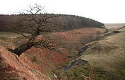
| Abbey Green cultivation marks |
Excavation |
ChesterChester is a city in Cheshire, England. Lying on the River Dee, close to the border with Wales, it is home to 77,040 inhabitants, and is the largest and most populous settlement of the wider unitary authority area of Cheshire West and Chester, which had a population of 328,100 according to the...
53.1933°N 2.8910°W |
Iron AgeThe Iron Age is the archaeological period generally occurring after the Bronze Age, marked by the prevalent use of iron. The early period of the age is characterized by the widespread use of iron or steel. The adoption of such material coincided with other changes in society, including differing...
|
CH103 |
Excavations in 1975–77 revealed striations in the sandstoneSandstone is a sedimentary rock composed mainly of sand-sized minerals or rock grains.Most sandstone is composed of quartz and/or feldspar because these are the most common minerals in the Earth's crust. Like sand, sandstone may be any colour, but the most common colours are tan, brown, yellow,...
bedrockIn stratigraphy, bedrock is the native consolidated rock underlying the surface of a terrestrial planet, usually the Earth. Above the bedrock is usually an area of broken and weathered unconsolidated rock in the basal subsoil...
indicating pre-Roman cultivation of the area. |
|
| Baddiley village |
Foundations |
Baddiley Baddiley is a scattered settlement and civil parish in the unitary authority of Cheshire East and the ceremonial county of Cheshire, England. The civil parish also includes the north-western part of the village of Ravensmoor , as well as the small settlements of Baddiley Hulse, Batterley Hill, and...
53.0497°N 2.5863°W |
Late SaxonAnglo-Saxon is a term used by historians to designate the Germanic tribes who invaded and settled the south and east of Great Britain beginning in the early 5th century AD, and the period from their creation of the English nation to the Norman conquest. The Anglo-Saxon Era denotes the period of...
and Medieval |
30389 |
There is evidence of house platforms and enclosures which indicate a deserted villageAn abandoned village is a village that has, for some reason, been deserted. In many countries, and throughout history, thousands of villages were deserted for a variety of causes...
. |
|
| Bartomley mound |
Mound |
Wincle Wincle is a small village and civil parish in the unitary authority of Cheshire East and the ceremonial county of Cheshire. The parish contains the village of Danebridge, which is larger than the village of Wincle itself. It holds parish meetings rather than parish council meetings.-External links:...
53.1882°N 2.0546°W |
Bronze Age The Bronze Age is a period characterized by the use of copper and its alloy bronze as the chief hard materials in the manufacture of some implements and weapons. Chronologically, it stands between the Stone Age and Iron Age...
|
33882 |
A round barrowRound barrows are one of the most common types of archaeological monuments. Although concentrated in Europe they are found in many parts of the world because of their simple construction and universal purpose....
which consists of a mound which is partly bedrock. The edges of it have been ploughed and two pits dug into it. |
|
| Bearhurst barrow |
Earthworks In archaeology, earthwork is a general term to describe artificial changes in land level. Earthworks are often known colloquially as 'lumps and bumps'. Earthworks can themselves be archaeological features or they can show features beneath the surface...
|
Henbury Henbury is a village and civil parish in the unitary authority of Cheshire East and the ceremonial county of Cheshire, England. According to the 2001 census, the entire civil parish had a population of 594....
53.2455°N 2.1912°W |
Bronze Age |
22583 |
A round barrow 50 feet (15 m) across and 6 feet (2 m) high. An excavation in 1965–66 revealed flintFlint is a hard, sedimentary cryptocrystalline form of the mineral quartz, categorized as a variety of chert. It occurs chiefly as nodules and masses in sedimentary rocks, such as chalks and limestones. Inside the nodule, flint is usually dark grey, black, green, white, or brown in colour, and...
s, pottery sherdIn archaeology, a sherd is commonly a historic or prehistoric fragment of pottery, although the term is occasionally used to refer to fragments of stone and glass vessels as well....
s and two urnAn urn is a vase, ordinarily covered, that usually has a narrowed neck above a footed pedestal. "Knife urns" placed on pedestals flanking a dining-room sideboard were an English innovation for high-style dining rooms of the late 1760s...
s, one of which contained a cremation. |
|
Beeston CastleBeeston Castle is a former Royal castle in Beeston, Cheshire, England , perched on a rocky sandstone crag above the Cheshire Plain. It was built in the 1220s by Ranulf de Blondeville, 6th Earl of Chester, , on his return from the Crusades...
hillfort |
Earthworks |
Beeston Beeston is a village and civil parish in the unitary authority of Cheshire West and Chester and the ceremonial county of Cheshire in the north of England. It is south of Tarporley, and close to the Shropshire Union Canal. Beeston Castle nearby is a spectacular clifftop ruin in the care of English...
53.1280°N 2.6919°W |
Late Bronze Age to late Iron Age |
23641 |
A hillfort on a prominent rocky outcrop. The site is now occupied by a ruined medieval castle which has obliterated the signs of earlier occupation. |
|
| Bent Farm Roman Camp |
Earthworks |
Newbold Astbury thumb|AstburyNewbold Astbury is a village and civil parish in the unitary authority of Cheshire East and the ceremonial county of Cheshire, in the north-west of England. It is situated to the south of Congleton on the A34 road to Scholar Green; the A34 forms one side of the triangular village green...
53.1549°N 2.2442°W |
RomanThe Roman Empire was the post-Republican period of the ancient Roman civilization, characterised by an autocratic form of government and large territorial holdings in Europe and around the Mediterranean....
|
25716 |
Earthworks were identified in 1725 as a Roman temporary camp but largely destroyed in 1744. Further investigations carried out in 1967. |
|
| Birch Hill |
CropmarkCropmarks or Crop marks are a means through which sub-surface archaeological, natural and recent features may be visible from the air or a vantage point on higher ground or a temporary platform...
s |
Manley right|thumb|200px|Map of civil parish of Manley within the former borough of Vale RoyalManley is a village and civil parish in the unitary authority of Cheshire West and Chester and the ceremonial county of Cheshire, in the north west of England.-External links:...
53.2600°N 2.7129°W |
Roman |
25714 |
A temporary Roman camp which was identified from cropmarks in 1994 by aerial reconnaissance Aerial archaeology is the study of archaeological remains by examining them from altitude.The advantages of gaining a good aerial view of the ground had been long appreciated by archaeologists as a high viewpoint permits a better appreciation of fine details and their relationships within the wider...
; no upstanding remains. |
|
| Birtles Hall barrow |
Earthworks |
Over Alderley Over Alderley is a civil parish in the Borough of Cheshire East and the ceremonial county of Cheshire, England. It has a population of 335.St Catherine's Church, Over Alderley is a Grade II* listed building, and Birtles Hall is listed Grade II....
53.2680°N 2.2190°W |
Bronze Age |
22577 |
A slightly oval (20m x 19m) round barrow consisting of a mound on top of a natural rise. |
|
| Blackrock Farm barrow |
Earthwork |
Ginclough, Rainow Rainow is a village and civil parish in the unitary authority of Cheshire East, located, mostly, on the eastern side of the River Dean valley next to the B5470 road, between Macclesfield and Kettleshulme in the ceremonial county of Cheshire, England. It straddles the eastern side of the Peak...
53.2865°N 2.0635°W |
Bronze Age |
22568 |
A turf-covered round barrow 22.5m in diameter and 1.6m high. |
|
| Blue Boar Farm barrow |
Earthworks |
Rainow
53.2844°N 2.0453°W |
Bronze Age |
22569 |
A round barrow, described in 1878 as a conical tumulus. It is now an oval (31.5m x 29m) mound of earth and stones up to 2m high. |
|
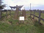
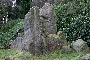
| Bowstones |
Standing stones |
Lyme Handley Lyme Handley, sometimes known as Lyme, is a small civil parish in between Disley and Stockport, in the unitary authority of Cheshire East and the ceremonial county of Cheshire, England...
53.3287°N 2.0406°W |
Late Saxon |
22589 |
Two cross The Christian cross, seen as a representation of the instrument of the crucifixion of Jesus Christ, is the best-known religious symbol of Christianity...
staffs set in a massive stone base. Each has traces of carved interlaced ornament. Carved initials have been added, probably in the Medieval period. |
|
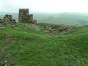
| Bradley Hillfort Bradley hill fort is an Iron Age hill fort. Hill forts were fortified hill-tops, used as settlements or temporary refuges, constructed across Britain during the Iron Age. It is the smallest of the seven hill forts in the county of Cheshire in northern England...
|
Earthworks |
KingsleyKingsley is a civil parish and a village in the unitary authority of Cheshire West and Chester and the ceremonial county of Cheshire, England. It is approximately 5 miles south east of the town of Frodsham....
53.2861°N 2.6926°W |
Iron Age |
25693 |
The smallest promontory hillfort A hill fort is a type of earthworks used as a fortified refuge or defended settlement, located to exploit a rise in elevation for defensive advantage. They are typically European and of the Bronze and Iron Ages. Some were used in the post-Roman period...
in the county. It has natural defences only to the north; the other defences have been damaged by ploughing. |
|
The BridestonesThe Bridestones consist of a chambered cairn, built in the Neolithic Stone Age, near Congleton, Cheshire, England. It was described in 1764 as being 100 metres long and 11 metres wide; it contained three separate compartments, of which only one remains today...
|
Stone structure |
CongletonCongleton is a town and civil parish in the unitary authority of Cheshire East and the ceremonial county of Cheshire, England, on the banks of the River Dane, to the west of the Macclesfield Canal and 21 miles south of Manchester. It has a population of 25,750.-History:The first settlements in...
53.1565°N 2.1398°W |
Neolithic The Neolithic Age, Era, or Period, or New Stone Age, was a period in the development of human technology, beginning about 9500 BC in some parts of the Middle East, and later in other parts of the world. It is traditionally considered as the last part of the Stone Age...
|
13500 |
The only known Neolithic tomb in the county, formerly a chambered long cairnA long barrow is a prehistoric monument dating to the early Neolithic period. They are rectangular or trapezoidal tumuli or earth mounds traditionally interpreted as collective tombs...
. Much of its fabric was removed in the mid-18th century to build a road. It now consists of a chamber enclosed by large stone slabs. |
|
| Brink Farm barrow |
Earthworks |
Rainow
53.3089°N 2.0445°W |
Bronze Age |
22570 |
A bowl-shaped round barrow consisting of a mound near the top of a knoll A hillock or knoll is a small hill, usually separated from a larger group of hills such as a range. Hillocks are similar in their distribution and size to small mesas or buttes. The term is largely a British one...
. |
|
| Bullstones |
Earthwork with upright stone |
Wincle
53.2052°N 2.0732°W |
Bronze Age |
22584 |
A cremation burial site in which the bones of a child or young person were found 3 foot (0.9144 m) below the surface surrounded by a stone circle 20 feet (6 m) in diameter. Inside the circle was an upright stone slab, which is still present. |
|
| Burton Point |
Earthworks |
Neston
53.2548°N 3.0460°W |
Iron Age |
25695 |
A promontory fort consisting of earthworks in an arc protecting a former headland overlooking the River DeeThe River Dee is a long river in the United Kingdom. It travels through Wales and England and also forms part of the border between the two countries....
|
|
| Capesthorne Hall barrow (south) |
Earthworks |
Siddington Siddington is a civil parish in the unitary authority of Cheshire East and the ceremonial county of Cheshire, England. It consists of farms, a picnic site, Redesmere, a half-mile long lake, and the Capesthorne Estate. The village is located at the crossroads of the A34 with the B5392 approximately...
53.2495°N 2.2336°W |
Bronze Age |
22575 |
A round barrow on a high point in woodland. |
|
| Capesthorne Hall barrow (north) |
Earthworks |
Siddington
53.2529°N 2.2365°W |
Bronze Age |
22576 |
A round barrow on the summit of a knoll. (The ornamental stone pedestalPedestal is a term generally applied to the support of a statue or a vase....
on its top is not part of the schedule.) |
|
| Carden Park barrow |
Earthworks |
Carden Carden is a small village and civil parish in the unitary authority of Cheshire West and Chester and the ceremonial county of Cheshire, England. The village of Carden consists of Higher Carden and Lower Carden...
53.0753°N 2.8007°W |
Bronze Age |
23635 |
An oval (32m x 25m) bowl barrowBowl Barrow is the name for a type of burial mound or tumulus. A barrow is a mound of earth used to cover a tomb. The bowl barrow gets its name from the fact that it looks like an upturned bowl...
of sand and earth on a saddle of higher ground (now in a golf course). |
|
| Charles Head barrow |
Earthworks |
Rainow
53.3051°N 2.0367°W |
Bronze Age |
23613 |
A round barrow on the crest of a ridge, now crossed by a drystone Dry stone is a building method by which structures are constructed from stones without any mortar to bind them together. Dry stone structures are stable because of their unique construction method, which is characterized by the presence of a load-bearing facade of carefully selected interlocking...
wall. |
|
Chester Roman AmphitheatreChester Amphitheatre is a Roman amphitheatre in Chester, Cheshire. The site is managed by English Heritage; it has been designated as a Grade I listed building, and a scheduled monument. The ruins currently exposed are those of a large stone amphitheatre, similar to those found in Continental...
|
Earthworks |
Chester
53.1893°N 2.8871°W |
Roman |
CH 85 |
Originally in wood, later in stone. The northern half has been excavated |
|
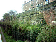
| Chester city walls .Chester city walls consist of a defensive structure built to protect the city of Chester in Cheshire, England. Their construction was started by the Romans when they established the fortress of Deva Victrix between 70 and 80 AD. It originated with a rampart of earth and turf surmounted by a...
|
City walls |
Chester
53.1923°N 2.8891°W |
Roman and MedievalThe Middle Ages is a periodization of European history from the 5th century to the 15th century. The Middle Ages follows the fall of the Western Roman Empire in 476 and precedes the Early Modern Era. It is the middle period of a three-period division of Western history: Classic, Medieval and Modern...
|
CH7 |
An almost complete circuit of red sandstone walls round the city. The north and east walls follow Roman foundations and contain fabric from that era. |
|
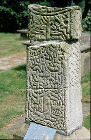
| Cleulow cross |
Standing stone |
Wincle
53.2038°N 2.0735°W |
Early Medieval/ Dark Age |
25645 |
A gritstone Gritstone or Grit is a hard, coarse-grained, siliceous sandstone. This term is especially applied to such sandstones that are quarried for building material. British gritstone was used for millstones to mill flour, to grind wood into pulp for paper and for grindstones to sharpen blades. "Grit" is...
pillar in a socket stone on a mound. The shaft is round and has the remains of a small wheelhead cross on the top. |
|
| Coddington barrow |
Earthworks |
Coddington Coddington is a civil parish in the unitary authority of Cheshire West and Chester and the ceremonial county of Cheshire, England.Coddington is home to descendants of the Great Richard Yeoward, who practically made Tenerife become know single handedly for its brilliant shipping and tasty...
53.0919°N 2.8187°W |
Bronze Age |
22588 |
A tree-covered mound of red sand with a surrounding ditch, scheduled as a bowl barrow. |
|
| Disley churchyard cross |
Stone |
DisleyDisley is a village and civil parish in the unitary authority of Cheshire East and the ceremonial county of Cheshire, England. It is located on the very edge of the Peak District, in the Goyt Valley, very close to the county boundary with Derbyshire at New Mills, and south of Stockport, Greater...
53.3575°N 2.0398°W |
Early Medieval/ Dark Age |
25631 |
A socket stone for two crosses in St Mary'sSt Mary's Church, Disley is a Church of England parish church in the diocese of Chester, the archdeaconry of Macclesfield and the deanery of Chadkirk. It is on a hill overlooking the village of Disley, Cheshire, England. It has been designated by English Heritage as a Grade II* listed building...
churchyard. It was discovered in 1958 and thought to be the setting for two Saxon crosses. |
|
| Eddisbury hillfort Eddisbury hill fort, also known as Castle Ditch, is an Iron Age hill fort near Delamere, Cheshire, in northern England. Hill forts are fortified hill-top settlements constructed across Britain during the Iron Age. Eddisbury is the largest and most complex of the seven hill forts in the county of...
|
Earthworks |
Delamere thumb|right|200px|Map of civil parish of Delamere within the former borough of Vale RoyalDelamere is a civil parish and village in Cheshire. It is situated approximately 7 miles to the west of Northwich, within the unitary authority of Cheshire West and Chester.The village is well-known for the...
53.2192°N 2.6705°W |
Iron Age |
25692 |
A former hillfort on a steep-sided sandstone projection on the east side of the mid-Cheshire ridge. The defences consist of two earth ramparts A defensive wall is a fortification used to protect a city or settlement from potential aggressors. In ancient to modern times, they were used to enclose settlements...
with a single ditch between them. |
|
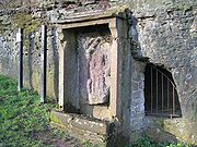
| Edgar's Cave |
Former quarry |
HandbridgeHandbridge is a district of Chester, England on the south bank of the River Dee. A settlement has existed on the site since the Iron age , but the site saw major expansion during the collapse of the Roman occupation of Britain, as the city grew too large for its walls...
53.1844°N 2.8887°W |
Roman |
27582 |
A quarryA quarry is a type of open-pit mine from which rock or minerals are extracted. Quarries are generally used for extracting building materials, such as dimension stone, construction aggregate, riprap, sand, and gravel. They are often collocated with concrete and asphalt plants due to the requirement...
which included a shrine to MinervaMinerva's Shrine, Chester, is a shrine to the Roman goddess, Minerva, in Edgar's Field, Handbridge, Chester, England. It has been designated by English Heritage as a Grade I listed building....
whose image is still visible. The shrine is a Grade I listed building. |
|
| Elm Bank Roman Camp |
CropmarkCropmarks or Crop marks are a means through which sub-surface archaeological, natural and recent features may be visible from the air or a vantage point on higher ground or a temporary platform...
|
Waverton Waverton is a village and civil parish in the unitary authority of Cheshire West and Chester and the ceremonial county of Cheshire, England. It lies about 5 km south east of Chester...
53.1701°N 2.8222°W |
Roman |
25715 |
Cropmarks show a rectangular enclosure which housed a Roman practice camp. |
|
| Engine Vein copper mine |
Trench and pits |
Nether Alderley Nether Alderley is a village and civil parish in the unitary authority of Cheshire East and the ceremonial county of Cheshire, England. It lies on the A34 road about a mile and a half south of Alderley Edge....
53.2941°N 2.2104°W |
Bronze Age and later |
33859 |
An opencast mine Open-pit mining or opencast mining refers to a method of extracting rock or minerals from the earth by their removal from an open pit or borrow....
for copper and other minerals in use from the early Bronze Age, in Roman and medieval times, through to the Victorian eraThe Victorian era of British history was the period of Queen Victoria's reign from 20 June 1837 until her death on 22 January 1901. It was a long period of peace, prosperity, refined sensibilities and national self-confidence...
|
|
| Gallowsclough Cob barrow |
Earthworks |
Oakmere Oakmere is a village and civil parish in the unitary authority of Cheshire West and Chester and the ceremonial county of Cheshire, England.Oakmere is situated on the A556 road, approximately west of Frodsham...
53.2373°N 2.6455°W |
Bronze Age |
22594 |
A round barrow excavated in 1960 which was found to contain a cremation burial. |
|
| Ginclough standing stone |
Standing stone |
Ginclough
53.2842°N 2.0683°W |
Late prehistoric |
25702 |
A large stone 1m high cut away on two sides |
|
| Harbutt's Field Roman fort |
Plan of Roman fort |
MiddlewichMiddlewich is a market town in the unitary authority of Cheshire East and the ceremonial county of Cheshire, England. It is east of the city of Chester, east of Winsford, southeast of Northwich and northwest of Sandbach....
53.1985°N 2.4472°W |
Roman |
12615 |
The complete plan of a Roman fort has been revealed by a geophysical Geophysics is the physics of the Earth and its environment in space; also the study of the Earth using quantitative physical methods. The term geophysics sometimes refers only to the geological applications: Earth's shape; its gravitational and magnetic fields; its internal structure and...
survey |
|
| Helsby Hill fort |
Earthworks |
HelsbyHelsby is a large village and civil parish in the unitary authority of Cheshire West and Chester and the ceremonial county of Cheshire, England. At the 2001 Census, Helsby had a population of 4,701.-Geography:...
Hill
53.2732°N 2.7630°W |
Iron Age |
25689 |
A promontory fort with naturally steep slopes to the west and north and an earth and stone rampart to the south. |
|
| Heronbridge Roman Site |
Earthworks |
Claverton
53.1709°N 2.8839°W |
Roman |
CH25 |
A Roman settlement on each side of Watling StreetWatling Street is the name given to an ancient trackway in England and Wales that was first used by the Britons mainly between the modern cities of Canterbury and St Albans. The Romans later paved the route, part of which is identified on the Antonine Itinerary as Iter III: "Item a Londinio ad...
with evidence of industrial activity in the late 1st and the 2nd century. |
|
| High Billinge barrow |
Earthworks |
Utkinton thumb|200px|Map of civil parish of Utkinton within the former borough of Vale RoyalUtkinton is a civil parish and small village in the unitary authority of Cheshire West and Chester and the ceremonial county of Cheshire, England. It is approximately 8 miles west of Winsford and north of Tarporley...
53.1911°N 2.6679°W |
Bronze Age |
23705 |
A round barrow 30m across and 1.8m high in woodland on a hill-top. |
|
| Hoole Roman Camp |
ParchmarkCropmarks or Crop marks are a means through which sub-surface archaeological, natural and recent features may be visible from the air or a vantage point on higher ground or a temporary platform...
|
Hoole Hoole is a suburb in the east of Chester, in the unitary authority of Cheshire West and Chester and the ceremonial county of Cheshire, England.-History:The settlement was first mentioned in the Register of the Abbey of Saint Werburgh in 1119...
53.2044°N 2.8551°W |
Roman |
27596 |
Aerial photography in August 1995 showed a rectangular enclosure, part of which lies under the A41 roadThe A41 is a formerly-major trunk road in England that links London and Birkenhead, although it has now largely been superseded by motorways. It passes through or near various towns and cities including Watford, Hemel Hempstead, Aylesbury, Solihull, Birmingham, West Bromwich, Wolverhampton,...
. |
|
| Ince Roman Fortlet |
Cropmarks |
InceInce is a village and civil parish in the unitary authority of Cheshire West and Chester and the ceremonial county of Cheshire, England. It is situated immediately to the east of the Stanlow Oil Refinery. It shares Ince and Elton railway station with the village of Elton, which it runs into...
53.2870°N 2.8303°W |
Roman |
27589 |
Aerial photography showed a double-ditched rectangular enclosure. Excavation revealed a piece of samian pottery and postholeIn archaeology a posthole is a cut feature used to hold a surface timber or stone. They are usually much deeper than they are wide although truncation may not make this apparent....
s. |
|
| Jodrell Bank barrow cemetery |
Earthworks |
Swettenham Swettenham is a village and civil parish in the unitary authority of Cheshire East and the ceremonial county of Cheshire, England. According to the 2001 Official UK Census, the population of the entire civil parish was 248....
53.2243°N 2.3036°W |
Bronze Age |
23654
23655
23656
23657 |
Four remaining round barrows from an original group of six. |
|
| Kelsborrow promontory fort Kelsborrow Castle is an Iron Age hill fort. Hill forts were fortified hill-top settlements constructed across Britain during the Iron Age. It is one of only seven hill forts in the county of Cheshire in northern England and was probably in use for only a short time. In the 19th century, a bronze...
|
Earthworks |
Delamere
53.2027°N 2.7026°W |
Iron Age |
25691 |
A promontory fort with steep sides to the south and a curving bank and ditch to the north. In the 19th century a palstave A Palstave is a type of early bronze axe. It was common in the mid Bronze Age in north, western and south-western Europe. In the technical sense, although precise definitions differ, an axe is generally deemed to be a palstave if it is hafted by means of a forked wooden handle kept in place with...
and a fragment of a sword were found. |
|
| Knightslow barrows |
Earthworks |
Lyme Handley
53.3319°N 2.0547°W |
Bronze Age |
22579
22580
22581
22582 |
A group of four round barrows in woodland on a hill. |
|
| London Road barrow |
Earthworks |
PrestburyPrestbury is a village, civil parish and ecclesiastical parish in the unitary authority of Cheshire East and the ceremonial county of Cheshire, England. Prestbury is a long, narrow parish covering 1,165 hectares to the west of the Peak Park foothills and to the east of the sandstone ridge which is...
53.3017°N 2.1398°W |
Bronze Age |
22578 |
A slightly oval (26m x 25m) barrow up to 1.3m in height. In 1808 a number of cairns were found, one of which contained cremations. |
|
| Long Lane barrow |
Earthworks |
Bickerton Bickerton is a village and civil parish in the unitary authority of Cheshire East and the ceremonial county of Cheshire, England, about eight miles north of Whitchurch in Shropshire. The parish also includes the small settlement of Gallantry Bank, with a total population of over 200...
53.0691°N 2.7320°W |
Bronze Age |
23636 |
A round barrow consisting of a low mound 24m in diameter and 0.5m high on a knoll to the east of Bickerton Hill Bickerton Hill refers to two low red sandstone hills that form the southern end of the Mid Cheshire Ridge in Cheshire, north-west England. The high point, Raw Head, lies on the northerly hill and has an elevation of 227 metres...
. |
|
| Longley Farm field system |
Earthworks |
Kelsall Kelsall is a medium-sized agricultural/commuter village and civil parish in the unitary authority of Cheshire West and Chester and the ceremonial county of Cheshire, England. It is located around east of Chester, west of Northwich and north west of Tarporley...
53.2247°N 2.7056°W |
Iron Age (or medieval/post-medieval) |
30375 |
A system of terraces Terraces are used in farming to cultivate sloped land. Graduated terrace steps are commonly used to farm on hilly or mountainous terrain. Terraced fields decrease erosion and surface runoff, and are effective for growing crops requiring much water, such as rice...
, lynchetA lynchet is a bank of earth that builds up on the downslope of a field ploughed over a long period of time. The disturbed soil slips down the hillside to create a positive lynchet while the area reduced in level becomes a negative lynchet. They are also referred to as strip lynchets.They are a...
s and enclosures |
|
Maiden CastleMaiden Castle is an Iron Age hill fort, one of many fortified hill-top settlements constructed across Britain during the Iron Age, but one of only seven in the county of Cheshire in northern England. The hill fort was probably occupied from its construction in 600 BC until the Roman conquest...
|
Earthworks |
Bickerton Hill Bickerton Hill refers to two low red sandstone hills that form the southern end of the Mid Cheshire Ridge in Cheshire, north-west England. The high point, Raw Head, lies on the northerly hill and has an elevation of 227 metres...
53.0708°N 2.7511°W |
Iron Age |
25690 |
A promontory hill fort on a spur with an earthwork defending its neck and two lines of ramparts on the south and east. |
|
| Meadows Farm barrow |
Earthworks |
Horton-cum-Malpas
53.0296°N 2.8146°W |
Bronze Age |
22587 |
A round barrow which contained an oak plank, possibly part of a coffin. |
|
| Moultonbank barrow |
Earthworks |
Moulton thumb|right|200px|Map of civil parish of Moulton within the former borough of Vale RoyalMoulton is a civil parish and village in the unitary authority of Cheshire West and Chester and near the centre of the ceremonial county of Cheshire, England, situated south of Northwich and north of...
53.2203°N 2.5211°W |
Bronze Age |
22596 |
A round barrow on the top of a glacial mound 35m in diameter and 1.5m high. |
|
| The Murder Stone |
Standing stone |
Lyme Handley
53.3261°N 2.0248°W |
Bronze Age |
25701 |
A standing stone consisting of a triangular slab of gritstone |
|
| Nab Head barrow |
Earthworks |
BollingtonBollington is a small rural town and civil parish in the county of Cheshire, , England, in the unitary authority of Cheshire East. It is located east of Prestbury. In the Middle Ages it was part of the Earl of Chester's manor of Macclesfield., and the ancient parish of Prestbury...
53.3058°N 2.0912°W |
Bronze Age |
22573 |
An oval (19m x 17m) barrow up to 1.8m high with a central depression, surrounded by a ditch. |
|
| North Cheshire Ridge Roman Road (1) |
Earthworks |
Appleton Thorn
53.3497°N 2.5461°W |
Roman |
WG78 |
Much of this portion of the road is now covered by the village hall car park. |
|
| North Cheshire Ridge Roman Road (2) |
Earthworks |
Stretton Stretton is a village and civil parish in Cheshire, England not far from Warrington. The parish includes the village of Lower Stretton. It is at the very southern tip of Warrington, about seven miles south of the town centre. It has a large hotel and is the site of Warrington's private hospital,...
53.3436°N 2.5600°W |
Roman |
WG78 |
Scheduled portion of the road near to Mosswood Hall |
|
| Oakmere hill fort Oakmere hill fort is an Iron Age hill fort, one of many large fortified settlements constructed across Britain during the Iron Age, but one of only seven in the county of Cheshire in northern England. It is protected as a Scheduled Ancient Monument...
|
Earthworks |
Oakmere
53.2060°N 2.6312°W |
Iron Age |
25688 |
A promontory fort on a spur protruding into the mereMere in English refers to a lake that is broad in relation to its depth, e.g. Martin Mere. A significant effect of its shallow depth is that for all or most of the time, it has no thermocline.- Etymology :...
with a rampart across the east side. |
|
| Peckforton Mere promontory fort |
Earthworks and cropmarks |
PeckfortonPeckforton is a scattered settlement and civil parish in the unitary authority of Cheshire East and the ceremonial county of Cheshire, England. The settlement is located to the north east of Malpas and miles to the west of Nantwich. The total population of the civil parish is somewhat over 100...
53.1144°N 2.6803°W |
Iron Age |
25703 |
A defensive settlement on a ridge with the mere to the southwest and marsh to the northwest and southeast. The northeast was defended by a ditch. |
|
| Picton Roman camp |
Cropmarks |
Picton Picton is a hamlet and civil parish situated near to Chester, in the Borough of Cheshire West and Chester and the ceremonial county of Cheshire in England. It has a population of 58....
53.2243°N 2.8677°W |
Roman |
27597 |
Aerial photography in July 1995 showed a rectangular enclosure which was probably a Roman practice camp. |
|
| Prestbury churchyard cross shaft |
Stone fragments |
Prestbury
53.2892°N 2.1508°W |
Early Medieval/ Dark Age |
25632 |
Three Saxon stone fragments cemented together in the churchyard of St Peter'sSt Peter's Church is the parish church of Prestbury, Cheshire, England. It is probably the fourth church on the site. The third, the Norman Chapel, stands in the churchyard. The church has been designated by English Heritage as a Grade I listed building. The Norman Chapel, the lychgate and...
; the lower two fragments come from one cross while the top one is from a different cross. |
|
| Reed Hill cairn |
Earthworks |
Lyme Handley
53.3155°N 2.0342°W |
Bronze Age |
23609 |
A round barrow on the apex of a natural mound. Excavation in 1911 revealed a gritstone burial chamber containing cremated human bones. |
|
| Robin Hood's Tump |
Earthworks |
Alpraham Alpraham is a village and civil parish in the unitary authority of Cheshire East and the ceremonial county of Cheshire, England. It is on the A51 road, between Nantwich and Chester, and is about seven miles north-west of Nantwich...
53.1346°N 2.6371°W |
Bronze Age |
22593 |
A sand and turf round barrow 17m in diameter and 1.5m high. Excavation revealed worked flints but no evidence of a burial. |
|
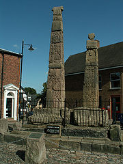
| Sandbach Crosses The Sandbach Crosses are two 9th-century Anglo-Saxon stone crosses now erected in the market place in the town of Sandbach, Cheshire, England. They are unusually large and elaborate examples of the type and have been designated by English Heritage as a Grade I listed building, and are a...
|
Standing stones |
SandbachSandbach is a market town and civil parish in the unitary authority of Cheshire East and the ceremonial county of Cheshire, England. The civil parish contains four settlements; Sandbach itself, Elworth, Ettiley Heath and Wheelock....
53.1440°N 2.3621°W |
Early Medieval/ Dark Age |
23637 |
A pair of Saxon crosses decorated with carvings on all faces. They have been moved on several occasions and were erected in their present position in 1816. They are listed Grade I. |
|
| Sandbach cross fragments |
Stones |
Sandbach
53.1435°N 2.3611°W |
Early Medieval/ Dark Age |
30396 |
Three fragments from the shaft of one or more Saxon crosses in St Mary's St Mary's Church, Sandbach is in the town of Sandbach, Cheshire, England. The church has been designated by English Heritage as a Grade II* listed building...
churchyard. |
|
| Seven Lows barrows |
Earthworks |
Delamere
53.1987°N 2.6550°W |
Bronze Age |
23616
23617
23644
23650
23651 |
Five barrows remaining out of an original total of seven. |
|
| Somerford Bridge barrow |
Earthwork |
Somerford Somerford is a civil parish in the unitary authority of Cheshire East and the ceremonial county of Cheshire, England. It is adjacent to the north west of Congleton, from which town it has some housing overflow. According to the 2001 census, the population of the civil parish was 343.-References:...
53.1677°N 2.2553°W |
Neolithic |
13499 |
A suspected long barrow, now a mound covered in oak trees. |
|
| Sponds Hill barrows |
Earthworks |
Lyme Handley
53.3194°N 2.0471°W |
Bronze Age |
22571
22572 |
Two round barrows, one on the summit of the hill, the other to the south. |
|
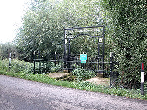
| St. Plegmund's well St. Plegmund's well lies about to the west of St Peter's Church, Plemstall near the village of Mickle Trafford, Cheshire, England . It is named after Plegmund, who later became Archbishop of Canterbury, and who is believed to have lived as a hermit nearby. The well is situated on the edge of a...
|
Holy wellA holy well, or sacred spring, is a small body of water emerging from underground and revered either in a Pagan or Christian context, often both. Holy wells were frequently pagan sacred sites that later became Christianized. The term 'holy well' is commonly employed to refer to any water source of...
|
Mickle Trafford Mickle Trafford is a village and civil parish in the unitary authority of Cheshire West and Chester and the ceremonial county of Cheshire, England. It includes the area known as Plemstall. In 2004 the population of the civil parish was estimated to be 2,140, although the 2001 census recorded...
53.2253°N 2.8175°W |
Early Medieval/ Dark Age |
30374 |
A well, now dry, surrounded by stone slabs |
|
| Stamford Heath enclosure |
Shown on aerial photographs |
Christleton Christleton is a small village and civil parish on the outskirts of Chester in the unitary authority of Cheshire West and Chester and the ceremonial county of Cheshire, England. The 2001 Census recorded a population for the entire civil parish of 2,112....
53.1972°N 2.8087°W |
Roman |
25729 |
Photography in 1947 revealed a rectangular earthwork enclosure which may be a Roman camp. |
|
| Stamford Lodge Roman Camp |
Cropmarks |
Christleton
53.1964°N 2.8179°W |
Roman |
25730 |
Photography in 1947 revealed a rectangular earthwork enclosure which may be a Roman camp. |
|
| Sutton Hall cairn |
Earthworks |
Sutton, Macclesfield
53.2388°N 2.1140°W |
Bronze Age |
22574 |
A round barrow 24m in diameter and up to 1.4m in height. When excavated in 1962 secondary cremations were found but no primary cremation. |
|
| Swettenham Hall barrow |
Earthworks |
Swettenham
53.1971°N 2.2801°W |
Bronze Age |
23614 |
A probable round barrow which has been spread by ploughing |
|
| Tatton settlement, old hall and mill dam |
Earthworks |
Tatton Park Tatton Park is a historic estate in Cheshire, England, to the north of the town of Knutsford. It contains a mansion, Tatton Hall, a manor house dating from medieval times, Tatton Old Hall, gardens, a farm and a deer park of . It is a popular visitor attraction and hosts over 100 events annually...
53.3286°N 2.3671°W |
Late Neolithic, Saxon, and Medieval |
30362 |
A former village occupied in the late Neolithic, Saxon and Medieval periods. Now deserted and only earthworks remain. The site includes the ground beneath Tatton Old Hall Tatton Old Hall is a historic building in Tatton Park near Knutsford, Cheshire, England. It has been designated by English Heritage as a Grade II* listed building which is owned by the National Trust and administered in conjunction with Cheshire East Council...
|
|
| Thieves Moss Roman road |
Site of road |
Delamere Forest Delamere Forest or Delamere Forest Park is a wood in the Cheshire West and Chester area of Cheshire, England, near the town of Frodsham. It includes of mixed deciduous and evergreen woodland, centred at around , making it the largest area of woodland in Cheshire...
53.2182°N 2.6563°W |
Roman |
CH30 |
The possible site of section of the ChesterChester is a city in Cheshire, England. Lying on the River Dee, close to the border with Wales, it is home to 77,040 inhabitants, and is the largest and most populous settlement of the wider unitary authority area of Cheshire West and Chester, which had a population of 328,100 according to the...
-ManchesterManchester is a city and metropolitan borough in Greater Manchester, England. According to the Office for National Statistics, the 2010 mid-year population estimate for Manchester was 498,800. Manchester lies within one of the UK's largest metropolitan areas, the metropolitan county of Greater...
Roman road. |
|
| Toot Hill barrow |
Mound |
Macclesfield Forest Macclesfield Forest is an area of woodland, predominantly conifer plantation, located around south east of Macclesfield in the civil parish of Macclesfield Forest and Wildboarclough, in Cheshire, England. The existing woodland is the last substantial remnant of the Royal Forest of Macclesfield, a...
53.2454°N 2.0440°W |
Bronze Age |
23612 |
An oval barrow of earth and stones at the centre of which is a gritstone slab. |
|
| Tytherington barrow |
Earthworks |
Tytherington Tytherington near Macclesfield in Cheshire, England is now a residential area. It was once very much a rural setting, with its own stone mansion named 'Tytherington Hall' or 'House', built by the wife of William Brocklehurst in the 19th century...
53.2712°N 2.1308°W |
Bronze Age |
22592 |
A round barrow, now in a housing development, which was found to contain a cremation and part of an urn. |
|
| Upton Heath Roman Camp |
Cropmark |
Upton Heath
53.2201°N 2.8744°W |
Roman |
25722 |
A rectangular round-cornered enclosure, possibly a Roman practice camp. |
|
| Upton Roman Camp |
Parchmarks |
Upton-by-Chester Upton by Chester is a civil parish and a large suburb on the outskirts of Chester, in the Borough of Cheshire West and Chester and the ceremonial county of Cheshire in England. It includes the villages of Upton and Upton Heath. At the 2001 Census the population was recorded as...
53.2196°N 2.8703°W |
Roman |
25723 |
Aerial photography in August 1989 showed a rectangular enclosure; no signs of it can be seen on the ground. |
|
| Upton Roman camp (1) |
Parchmarks |
Upton-by-Chester
53.2233°N 2.8721°W |
Roman |
25724 |
Aerial photography in August 1990 showed a rectangular enclosure with a rounded entrance. |
|
| Upton Roman camp (2) |
Cropmarks |
Upton-by-Chester
53.2168°N 2.8695°W |
Roman |
25726 |
Aerial photography has shown a rectangular enclosure. Further investigations have revealed evidence of a ditch and sherd In archaeology, a sherd is commonly a historic or prehistoric fragment of pottery, although the term is occasionally used to refer to fragments of stone and glass vessels as well....
s of Roman pottery. |
|
| West Park cross shafts |
Three standing stones |
West Park, MacclesfieldMacclesfield is a market town within the unitary authority of Cheshire East, the county palatine of Chester, also known as the ceremonial county of Cheshire, England. The population of the Macclesfield urban sub-area at the time of the 2001 census was 50,688...
53.2634°N 2.1365°W |
Early Medieval/ Dark Age |
25633 |
Three Saxon circular crosses with traces of ornamental sculpting, now mounted in a public park. |
|
| Whitley barrow |
Earthworks |
Lower WhitleyWhitley is a civil parish in the unitary authority of Cheshire West and Chester and the ceremonial county of Cheshire, England. It is surrounded by the parishes of Antrobus, Comberbach, Little Leigh and Dutton...
53.3099°N 2.5747°W |
Bronze Age |
23615 |
A slightly oval round barrow |
|
| Wilderspool Roman site |
Excavation |
Wilderspool Wilderspool is a district of Warrington, England, located near to the town centre. Its area is basically Wilderspool Causeway and the streets coming off it; the limits being the River Mersey into the Stockton Heath Area of Warrington , Bridgefoot , and Centre Park...
53.3750°N 2.5871°W |
Roman |
WG110 |
Excavations have shown parts of a walled town with evidence of industrial activity. |
|
| Winwick barrow |
Earthworks |
Highfield Lane, Winwick Winwick is a village and civil parish in the borough of Warrington in Cheshire, England. Historically within Lancashire, until 1 April 1974, Winwick was administered as part of Lancashire with the rest of north Warrington. It is situated about three miles north of Warrington town centre, near...
53.4342°N 2.5827°W |
Bronze Age |
22597 |
A round barrow, formerly part of a cemetery. Excavation in 1860 revealed a large urn containing human bones, a stone axe hammer and a bronze spear head. |
|
| Withington Hall barrow cemetery |
Earthworks |
Withington, Macclesfield
53.2482°N 2.2911°W |
Bronze Age |
22585
22586 |
Three round barrows, two of which have been excavated revealing evidence of cremations. |
|
| Woodhouse hillfort |
Stone and earth bank |
FrodshamFrodsham is a market town and civil parish in the unitary authority of Cheshire West and Chester and the ceremonial county of Cheshire, England. Its population is 8,982. It is approximately south of Runcorn, 16 miles south of Liverpool, and approximately south-west of Manchester...
53.2763°N 2.7350°W |
Iron Age |
25694 |
A promontory hillfort with steep slopes on the south and west sides and a stone and earth bank on the other sides. |
|
| Wybunbury church site |
Foundations |
WybunburyWybunbury is a village and civil parish in the unitary authority of Cheshire East and the ceremonial county of Cheshire, England. The village lies 3¼ miles to the south east of Nantwich and 3¾ miles to the south of Crewe. The parish also includes the settlements of Clannor Heath, Daisy Hill, The...
53.0452°N 2.4486°W |
Late Saxon |
32564 |
A church was present in the DomesdayDomesday Book , now held at The National Archives, Kew, Richmond upon Thames in South West London, is the record of the great survey of much of England and parts of Wales completed in 1086...
survey. The subsequent Medieval church of St ChadsSt Chad's Church, Wybunbury was an Anglican church in the village of Wybunbury, Cheshire, England. The body of the church has been demolished but the tower still stands. The tower has been designated by English Heritage as a Grade II* listed building. The site of the church is a Scheduled...
(other than the tower) has been demolished and the site is scheduled. |
|
| Yearn's Low barrow |
Earthworks |
Rainow
53.2806°N 2.0548°W |
Bronze Age |
22567 |
A round barrow 19m in diameter in which Roman coins and other objects have been found. |
|


.jpg)