
Peckforton
Encyclopedia
Peckforton is a scattered settlement (centred at ) and civil parish in the unitary authority of Cheshire East
and the ceremonial county of Cheshire
, England
. The settlement is located 6.5 miles (10.5 km) to the north east of Malpas
and 7.5 miles (12.1 km) miles to the west of Nantwich
. The total population of the civil parish is somewhat over 100. Nearby villages include Bulkeley
to the south, Beeston
to the north, Higher Burwardsley
to the west, Spurstow
to the east and Bunbury
to the north east.
The Peckforton Hills
form the western part of the civil parish. At the northern end of the ridge stands Peckforton Castle
, a Victorian mansion built in imitation of a medieval castle for John Tollemache, 1st Baron Tollemache
, and many of the local buildings were constructed in the mid-Victorian period for Lord Tollemache as part of the Peckforton Estate.
of 1086, when it was held by Wulfric. The survey lists land for two ploughs. Peckforton fell in the ancient parish
of Bunbury in the Eddisbury Hundred
.
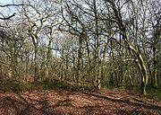
Peckforton and the adjacent Beeston were part of an estate purchased by John Tollemache, 1st Baron Tollemache in 1840. Lord Tollemache built Peckforton Castle in 1844–50. Praised as a model landlord, he had over fifty farms and many cottages built on his Cheshire estate, at a cost of around £280,000. Labourers were encouraged to rent 3 acres (12,140.6 m²) of land to farm to supplement their income. The woods that surround the castle were largely planted in 1922. , the Tollemache family remain the major landowners in Peckforton, although the castle itself was sold in 1989.
Borough Council, which was succeeded on 1 April 2009 by the new unitary authority
of Cheshire East
. Peckforton falls in the parliamentary constituency of Eddisbury
, and has been represented by Stephen O'Brien since 1999.
 The civil parish has a total area of 1754 acres (709.8 ha). The sandstone ridge of the Peckforton Hills
runs broadly north–south in the west of the civil parish, with high points at Peckforton Point and Stanner Nab . A 57.88 hectares area of Peckforton Woods has been designated a Site of Special Scientific Interest
, and the hills have also been designated county sites of biological importance for their woodland and grassland habitats. The Peckforton Hills are the source of the Weaver
and the Gowy
rivers; the Weaver flows southwards through the parish, while the Gowy flows northwards.
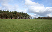 To the east of Stone House Lane, the land is gently undulating with an elevation mainly within the range of 75–100 metres. The land use in this part of the civil parish is agricultural, predominantly pasture with some arable land. This area also includes the woodland and plantations of Peckforton Moss , Peckforton Wood , Brickkiln Wood and part of Willis's Wood , as well as Peckforton Mere and many smaller ponds and meres.
The A49
forms part of the eastern boundary of the civil parish. Stone House Lane runs north–south through the parish, with Peckforton Hall Lane running eastwards from it. The Sandstone Trail
long-distance footpath runs along the Peckforton ridge.
recorded a population of 116 in 52 households.
This represents a decline from historical population figures, which were 260 (1801), 286 (1851), 176 (1901) and 140 (1951).
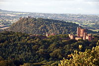
At the northern end of the Peckforton ridge stands the grade-I-listed Peckforton Castle , a Victorian replica of a medieval castle
designed by Anthony Salvin
in 1844–50 for John Tollemache
. Built around a walled courtyard with battlements and towers, the castle stands opposite the genuinely medieval Beeston Castle
, and is surrounded by a dry moat. George Gilbert Scott
called it "the very height of masquerading". Uninhabited since the Second World War
, the castle has been used as a film and television location, and as a venue for civil weddings and live-action fantasy role playing
. , it is an hotel.
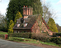
Also by Salvin are the castle's small private chapel and the gatehouse on Stone House Lane. Both, like the castle, are in rock-faced stone. The gatehouse consists of an archway and circular turret with a two-storey lodge attached. Both buildings are listed at grade II*.
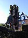 A red sandstone carving depicting an elephant bearing a castle stands in a garden on Stone House Lane in Peckforton village. It dates from around 1859 and is listed at grade II. It was carved by John or William Watson, a local stonemason then working on Peckforton Castle
who also carved stone lions now at Spurstow
and Tattenhall
. The elephant and the castle are each carved from a single piece of stone, which derives from the same quarry as Peckforton Castle. The elephant has a tasselled saddle, supporting the castle which has three tiers, with a turretted gatehouse and a keep with turrets at the corner. Some of the castle windows are glazed.
The original purpose of the carving is unclear. The device formed part of the crest of the Worshipful Company of Cutlers
and is often associated with public houses, but there has never been a pub called The Elephant and the Castle in Peckforton. An elephant also appears in the arms of the Corbett family, local landowners before 1626. According to one source, the carving was originally intended as a beehive, although there is no evidence it has ever been used as one.
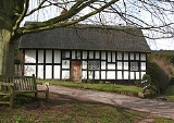
cottages dating from the early 17th century. Black and White Cottage on Stone House Lane is a single-storey, timber-framed, thatched cottage dating from the late 17th century with an attached byre under the same roof; the cottage is listed at grade II* for its unusually well-preserved interior.
Other black-and-white cottages include Garden Cottage and Hillside Cottage in the village, and Hill Lane Cottage on Hill Lane. Rock Cottage is unusual in being constructed in sandstone, while Smithy Cottage is a timber-framed cottage infilled with a mixture of brick and sandstone. On Peckforton Gap in the south of the civil parish stands The Gap, another stone cottage. All date from the late 17th century and are listed at grade II.
 To the east of the village on Peckforton Hall Lane stands Peckforton Hall , a grade-II*-listed farmhouse dating from the late 17th century. In red brick with a slate roof, the hall has twin gabled bays with a later ungabled wing. The nearby former farm building of the same date is timber-framed with a mixture of stone, brick and oak boarding; it is also listed at grade II.
Several former Peckforton Estate cottages, built for John Tollemache
in around 1860, are listed at grade II. Constructed in red or brown brick, they typically have a single storey with an attic and feature lozenge windows and prominent chimney stacks. Examples include Fountain Cottages, Green Cottage and Mill Beck Cottage.
Manor Farm stands on Peckforton Hall Lane at the east of the village and is typical of farmhouses built for the Peckforton Estate. The farmhouse dates from around 1870 and is in red brick with three bays, lozenge windows and timber studding to the gables. Both the farmhouse and the adjacent farm building of the same date are listed at grade II. Hillside Farm on Stone House Lane south of the village is another former estate farm, also dating from 1870. The farm house and adjacent farm building are grade II listed.
and Tarporley High School
in Tarporley
.
Cheshire East
Cheshire East is a unitary authority area with borough status in the ceremonial county of Cheshire, England.The borough was established in April 2009 as part of the 2009 structural changes to local government in England, by virtue of an order under the Local Government and Public Involvement in...
and the ceremonial county of Cheshire
Cheshire
Cheshire is a ceremonial county in North West England. Cheshire's county town is the city of Chester, although its largest town is Warrington. Other major towns include Widnes, Congleton, Crewe, Ellesmere Port, Runcorn, Macclesfield, Winsford, Northwich, and Wilmslow...
, England
England
England is a country that is part of the United Kingdom. It shares land borders with Scotland to the north and Wales to the west; the Irish Sea is to the north west, the Celtic Sea to the south west, with the North Sea to the east and the English Channel to the south separating it from continental...
. The settlement is located 6.5 miles (10.5 km) to the north east of Malpas
Malpas, Cheshire
Malpas is a large village which used to be a market town, and it is also a civil parish in the unitary authority of Cheshire West and Chester and the ceremonial county of Cheshire, England. The parish lies on the border with Shropshire and Wales...
and 7.5 miles (12.1 km) miles to the west of Nantwich
Nantwich
Nantwich is a market town and civil parish in the Borough of Cheshire East and the ceremonial county of Cheshire, England. The town gives its name to the parliamentary constituency of Crewe and Nantwich...
. The total population of the civil parish is somewhat over 100. Nearby villages include Bulkeley
Bulkeley
Bulkeley is a village and civil parish in the unitary authority of Cheshire East and the ceremonial county of Cheshire, England. The village is situated at on the A534 about 9 miles west of Nantwich. The civil parish also includes the small settlement of Bulkelehay at , with a total population...
to the south, Beeston
Beeston, Cheshire
Beeston is a village and civil parish in the unitary authority of Cheshire West and Chester and the ceremonial county of Cheshire in the north of England. It is south of Tarporley, and close to the Shropshire Union Canal. Beeston Castle nearby is a spectacular clifftop ruin in the care of English...
to the north, Higher Burwardsley
Burwardsley
Burwardsley is a village and civil parish the unitary authority of Cheshire West and Chester and the ceremonial county of Cheshire, England. The parish also includes the small villages of Burwardsley, Burwardsley Hill, Higher Burwardsley. The parish also includes Burwardsley Hall and is part of...
to the west, Spurstow
Spurstow
Spurstow is a village and civil parish in the unitary authority of Cheshire East and the ceremonial county of Cheshire, England, which is located 6½ miles to the north west of Nantwich. The parish also includes the settlement of Spurstow Sketh and part of Radmore Green. Nearby villages include...
to the east and Bunbury
Bunbury, Cheshire
Bunbury is a village and civil parish in the unitary authority of Cheshire East and the ceremonial county of Cheshire, England, south of Tarporley, north west of Nantwich, and on the Shropshire Union Canal...
to the north east.
The Peckforton Hills
Peckforton Hills
The Peckforton Hills are a sandstone ridge running broadly northeast–southwest in the west of the English county of Cheshire. They form a significant part of the longer Mid Cheshire Ridge which extends southwards from Frodsham towards Malpas....
form the western part of the civil parish. At the northern end of the ridge stands Peckforton Castle
Peckforton Castle
Peckforton Castle is a country house built in the style of a medieval castle. It stands in woodland at the north end of Peckforton Hills northwest of the village of Peckforton, Cheshire, England. It has been designated by English Heritage as a Grade I listed building...
, a Victorian mansion built in imitation of a medieval castle for John Tollemache, 1st Baron Tollemache
John Tollemache, 1st Baron Tollemache
John Jervis Tollemache, 1st Baron Tollemache , was a British Conservative Member of Parliament and a major landowner and estate manager in Cheshire.-Personal life and career:...
, and many of the local buildings were constructed in the mid-Victorian period for Lord Tollemache as part of the Peckforton Estate.
History
The Peckforton Hills were quarried during the Roman era. Peckforton appears in the Domesday surveyDomesday Book
Domesday Book , now held at The National Archives, Kew, Richmond upon Thames in South West London, is the record of the great survey of much of England and parts of Wales completed in 1086...
of 1086, when it was held by Wulfric. The survey lists land for two ploughs. Peckforton fell in the ancient parish
Ancient parishes of Cheshire
The Ancient Parishes of Cheshire refers to the group of parishes that existed in Cheshire, roughly within the period of 1200–1800. Initially, the ancient parishes had only an ecclesiastical function, but reforms initiated by King Henry VIII, developed by Queen Elizabeth I and expanded by...
of Bunbury in the Eddisbury Hundred
Hundreds of Cheshire
The Hundreds of Cheshire, as with other Hundreds in England were the geographic divisions of Cheshire for administrative, military and judicial purposes. They were introduced in Cheshire some time before the Norman conquest...
.
Peckforton and the adjacent Beeston were part of an estate purchased by John Tollemache, 1st Baron Tollemache in 1840. Lord Tollemache built Peckforton Castle in 1844–50. Praised as a model landlord, he had over fifty farms and many cottages built on his Cheshire estate, at a cost of around £280,000. Labourers were encouraged to rent 3 acres (12,140.6 m²) of land to farm to supplement their income. The woods that surround the castle were largely planted in 1922. , the Tollemache family remain the major landowners in Peckforton, although the castle itself was sold in 1989.
Governance
Peckforton has a parish meeting rather than a parish council. From 1974 the civil parish was served by Crewe and NantwichCrewe and Nantwich
Crewe and Nantwich was, from 1974 to 2009, a local government district with borough status in Cheshire, England. It had a population of 111,007...
Borough Council, which was succeeded on 1 April 2009 by the new unitary authority
Unitary authority
A unitary authority is a type of local authority that has a single tier and is responsible for all local government functions within its area or performs additional functions which elsewhere in the relevant country are usually performed by national government or a higher level of sub-national...
of Cheshire East
Cheshire East
Cheshire East is a unitary authority area with borough status in the ceremonial county of Cheshire, England.The borough was established in April 2009 as part of the 2009 structural changes to local government in England, by virtue of an order under the Local Government and Public Involvement in...
. Peckforton falls in the parliamentary constituency of Eddisbury
Eddisbury (UK Parliament constituency)
Eddisbury is a county constituency represented in the House of Commons of the Parliament of the United Kingdom. It elects one Member of Parliament by the first-past-the-post system of election.- Boundaries :...
, and has been represented by Stephen O'Brien since 1999.
Geography and transport
Peckforton Hills
The Peckforton Hills are a sandstone ridge running broadly northeast–southwest in the west of the English county of Cheshire. They form a significant part of the longer Mid Cheshire Ridge which extends southwards from Frodsham towards Malpas....
runs broadly north–south in the west of the civil parish, with high points at Peckforton Point and Stanner Nab . A 57.88 hectares area of Peckforton Woods has been designated a Site of Special Scientific Interest
Site of Special Scientific Interest
A Site of Special Scientific Interest is a conservation designation denoting a protected area in the United Kingdom. SSSIs are the basic building block of site-based nature conservation legislation and most other legal nature/geological conservation designations in Great Britain are based upon...
, and the hills have also been designated county sites of biological importance for their woodland and grassland habitats. The Peckforton Hills are the source of the Weaver
River Weaver
The River Weaver is a river, navigable in its lower reaches, running in a curving route anti-clockwise across west Cheshire, northern England. Improvements to the river to make it navigable were authorised in 1720 and the work, which included eleven locks, was completed in 1732...
and the Gowy
River Gowy
The River Gowy is a river in Cheshire, England and a tributary of the River Mersey.It rises in western Cheshire in the hills near Peckforton Castle, very close to the source of the River Weaver. While the Weaver flows south initially, the Gowy flows north and for several miles provides the valley...
rivers; the Weaver flows southwards through the parish, while the Gowy flows northwards.
The A49
A49 road
The A49 is a major road in western England, which traverses the Welsh Marches region. It runs north from Ross-on-Wye in Herefordshire via Hereford, Leominster, Ludlow, Shrewsbury and Whitchurch, then continues through central Cheshire to Warrington and Wigan before terminating at its junction with...
forms part of the eastern boundary of the civil parish. Stone House Lane runs north–south through the parish, with Peckforton Hall Lane running eastwards from it. The Sandstone Trail
Sandstone Trail
The Sandstone Trail is a long-distance walkers' path, following sandstone ridges running north–south from Frodsham in central Cheshire to Whitchurch just over the Shropshire border. The path was created in 1974 and extended in the 1990s...
long-distance footpath runs along the Peckforton ridge.
Demography
In 2006, the total population of the civil parish was estimated as 150. The 2001 censusUnited Kingdom Census 2001
A nationwide census, known as Census 2001, was conducted in the United Kingdom on Sunday, 29 April 2001. This was the 20th UK Census and recorded a resident population of 58,789,194....
recorded a population of 116 in 52 households.
This represents a decline from historical population figures, which were 260 (1801), 286 (1851), 176 (1901) and 140 (1951).
Peckforton Castle
At the northern end of the Peckforton ridge stands the grade-I-listed Peckforton Castle , a Victorian replica of a medieval castle
Castle
A castle is a type of fortified structure built in Europe and the Middle East during the Middle Ages by European nobility. Scholars debate the scope of the word castle, but usually consider it to be the private fortified residence of a lord or noble...
designed by Anthony Salvin
Anthony Salvin
Anthony Salvin was an English architect. He gained a reputation as an expert on medieval buildings and applied this expertise to his new buildings and his restorations...
in 1844–50 for John Tollemache
John Tollemache, 1st Baron Tollemache
John Jervis Tollemache, 1st Baron Tollemache , was a British Conservative Member of Parliament and a major landowner and estate manager in Cheshire.-Personal life and career:...
. Built around a walled courtyard with battlements and towers, the castle stands opposite the genuinely medieval Beeston Castle
Beeston Castle
Beeston Castle is a former Royal castle in Beeston, Cheshire, England , perched on a rocky sandstone crag above the Cheshire Plain. It was built in the 1220s by Ranulf de Blondeville, 6th Earl of Chester, , on his return from the Crusades...
, and is surrounded by a dry moat. George Gilbert Scott
George Gilbert Scott
Sir George Gilbert Scott was an English architect of the Victorian Age, chiefly associated with the design, building and renovation of churches, cathedrals and workhouses...
called it "the very height of masquerading". Uninhabited since the Second World War
World War II
World War II, or the Second World War , was a global conflict lasting from 1939 to 1945, involving most of the world's nations—including all of the great powers—eventually forming two opposing military alliances: the Allies and the Axis...
, the castle has been used as a film and television location, and as a venue for civil weddings and live-action fantasy role playing
Role-playing game
A role-playing game is a game in which players assume the roles of characters in a fictional setting. Players take responsibility for acting out these roles within a narrative, either through literal acting, or through a process of structured decision-making or character development...
. , it is an hotel.
Also by Salvin are the castle's small private chapel and the gatehouse on Stone House Lane. Both, like the castle, are in rock-faced stone. The gatehouse consists of an archway and circular turret with a two-storey lodge attached. Both buildings are listed at grade II*.
Elephant and castle carving
Peckforton Castle
Peckforton Castle is a country house built in the style of a medieval castle. It stands in woodland at the north end of Peckforton Hills northwest of the village of Peckforton, Cheshire, England. It has been designated by English Heritage as a Grade I listed building...
who also carved stone lions now at Spurstow
Spurstow
Spurstow is a village and civil parish in the unitary authority of Cheshire East and the ceremonial county of Cheshire, England, which is located 6½ miles to the north west of Nantwich. The parish also includes the settlement of Spurstow Sketh and part of Radmore Green. Nearby villages include...
and Tattenhall
Tattenhall
Tattenhall is a village and civil parish, 8 miles south-east of Chester, in the unitary authority of Cheshire West and Chester and the ceremonial county of Cheshire, England. At the 2001 Census, the population was recorded as 1,986.-History:...
. The elephant and the castle are each carved from a single piece of stone, which derives from the same quarry as Peckforton Castle. The elephant has a tasselled saddle, supporting the castle which has three tiers, with a turretted gatehouse and a keep with turrets at the corner. Some of the castle windows are glazed.
The original purpose of the carving is unclear. The device formed part of the crest of the Worshipful Company of Cutlers
Worshipful Company of Cutlers
The Worshipful Company of Cutlers is one of the Livery Companies of the City of London. The trade of knife making and repairing was organised in the thirteenth century; the organisation received a Royal Charter later in 1416...
and is often associated with public houses, but there has never been a pub called The Elephant and the Castle in Peckforton. An elephant also appears in the arms of the Corbett family, local landowners before 1626. According to one source, the carving was originally intended as a beehive, although there is no evidence it has ever been used as one.
Listed buildings
Peckforton has a diverse collection of listed buildings. Probably the earliest remaining buildings in the civil parish are Manor Farm Cottage and Yew Tree Cottage, grade-II-listed timber-framedTimber framing
Timber framing , or half-timbering, also called in North America "post-and-beam" construction, is the method of creating structures using heavy squared off and carefully fitted and joined timbers with joints secured by large wooden pegs . It is commonplace in large barns...
cottages dating from the early 17th century. Black and White Cottage on Stone House Lane is a single-storey, timber-framed, thatched cottage dating from the late 17th century with an attached byre under the same roof; the cottage is listed at grade II* for its unusually well-preserved interior.
Other black-and-white cottages include Garden Cottage and Hillside Cottage in the village, and Hill Lane Cottage on Hill Lane. Rock Cottage is unusual in being constructed in sandstone, while Smithy Cottage is a timber-framed cottage infilled with a mixture of brick and sandstone. On Peckforton Gap in the south of the civil parish stands The Gap, another stone cottage. All date from the late 17th century and are listed at grade II.
Several former Peckforton Estate cottages, built for John Tollemache
John Tollemache, 1st Baron Tollemache
John Jervis Tollemache, 1st Baron Tollemache , was a British Conservative Member of Parliament and a major landowner and estate manager in Cheshire.-Personal life and career:...
in around 1860, are listed at grade II. Constructed in red or brown brick, they typically have a single storey with an attic and feature lozenge windows and prominent chimney stacks. Examples include Fountain Cottages, Green Cottage and Mill Beck Cottage.
Manor Farm stands on Peckforton Hall Lane at the east of the village and is typical of farmhouses built for the Peckforton Estate. The farmhouse dates from around 1870 and is in red brick with three bays, lozenge windows and timber studding to the gables. Both the farmhouse and the adjacent farm building of the same date are listed at grade II. Hillside Farm on Stone House Lane south of the village is another former estate farm, also dating from 1870. The farm house and adjacent farm building are grade II listed.
Education
There are no educational facilities within the civil parish. The parish falls within the catchment areas of Bunbury Aldersey Church of England Primary School in BunburyBunbury, Cheshire
Bunbury is a village and civil parish in the unitary authority of Cheshire East and the ceremonial county of Cheshire, England, south of Tarporley, north west of Nantwich, and on the Shropshire Union Canal...
and Tarporley High School
Tarporley Community High School
Tarporley High School and Sixth Form College is a secondary school in the village of Tarporley, Cheshire, England.-Admissions:It has around 1,000 pupils with 64 teachers. It is an over-subscribed school...
in Tarporley
Tarporley
Tarporley is a large village and civil parish in the unitary authority of Cheshire West and Chester and the ceremonial county of Cheshire, England....
.