

Aerial archaeology
Encyclopedia
The advantages of gaining a good aerial view of the ground had been long appreciated by archaeologists as a high viewpoint permits a better appreciation of fine details and their relationships within the wider site context. Early investigators attempted to gain birdseye views of sites using hot air balloons, scaffolds or cameras attached to kites. Following the invention of the aeroplane
Fixed-wing aircraft
A fixed-wing aircraft is an aircraft capable of flight using wings that generate lift due to the vehicle's forward airspeed. Fixed-wing aircraft are distinct from rotary-wing aircraft in which wings rotate about a fixed mast and ornithopters in which lift is generated by flapping wings.A powered...
and the military importance placed on aerial photography
Aerial photography
Aerial photography is the taking of photographs of the ground from an elevated position. The term usually refers to images in which the camera is not supported by a ground-based structure. Cameras may be hand held or mounted, and photographs may be taken by a photographer, triggered remotely or...
during the First
World War I
World War I , which was predominantly called the World War or the Great War from its occurrence until 1939, and the First World War or World War I thereafter, was a major war centred in Europe that began on 28 July 1914 and lasted until 11 November 1918...
and Second World Wars, archaeologists were able to more effectively use the technique to discover and record archaeological sites.
Photographs may be taken either vertically, that is from directly overhead, or obliquely, meaning that they are taken at an angle. In order to provide a three-dimensional effect, an overlapping pair of vertical photographs, taken from slightly offset positions, can be viewed stereoscopically.
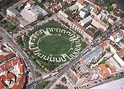
Large sites could for the first time be viewed accurately, in their entirety and within their landscape. This aided the production of drawn plans and also inspired archaeologists to look beyond the discrete monument
Monument
A monument is a type of structure either explicitly created to commemorate a person or important event or which has become important to a social group as a part of their remembrance of historic times or cultural heritage, or simply as an example of historic architecture...
and to appreciate a site's role within its setting. Photos are taken vertically for the purposes of planning and spatial analysis
Spatial analysis
Spatial analysis or spatial statistics includes any of the formal techniques which study entities using their topological, geometric, or geographic properties...
and obliquely to emphasize certain features or give perspective. Through the process of photogrammetry
Photogrammetry
Photogrammetry is the practice of determining the geometric properties of objects from photographic images. Photogrammetry is as old as modern photography and can be dated to the mid-nineteenth century....
, vertical photos can be converted into scaled plans.
Archaeological features may also be more visible from the air than on the ground. In temperate Europe, aerial reconnaissance is one of the most important ways in which new archaeological sites are discovered. Tiny differences in ground conditions caused by buried features can be emphasised by a number of factors and then viewed from the air:
- Slight differences in ground levels will cast shadows when the sun is low and these can be seen best from an aeroplane. These are referred to as shadow marks.
- Buried ditches will hold more water and buried walls will hold less water than undisturbed ground, this phenomenon, amongst others, causes crops to grow better or worse, taller or shorter, over each kind of ground and therefore define buried features which are apparent as tonal or colour differences. Such effects are called cropmarkCropmarkCropmarks or Crop marks are a means through which sub-surface archaeological, natural and recent features may be visible from the air or a vantage point on higher ground or a temporary platform...
s. - Frost can also appear in winter on ploughed fields where water has naturally accumulated along the lines of buried features. These are known as frostmarks.
- Slight differences in soil colour between natural deposits and archaeological ones can also often show in ploughed fields as soilmarks
- Differences in levels and buried features will also affect the way surface water behaves across a site and can produce a striking effect after heavy rain.
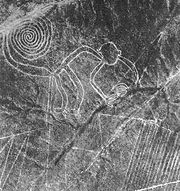
In cases like the Nazca lines
Nazca Lines
The Nazca Lines are a series of ancient geoglyphs located in the Nazca Desert in southern Peru. They were designated a UNESCO World Heritage Site in 1994. The high, arid plateau stretches more than between the towns of Nazca and Palpa on the Pampas de Jumana about 400 km south of Lima...
, the features are meaningless from the ground but easily visible from the air.
Pioneers of aerial archaeology include Roger Agache in Northern France
France
The French Republic , The French Republic , The French Republic , (commonly known as France , is a unitary semi-presidential republic in Western Europe with several overseas territories and islands located on other continents and in the Indian, Pacific, and Atlantic oceans. Metropolitan France...
, Antoine Poidebard in Syria
Syria
Syria , officially the Syrian Arab Republic , is a country in Western Asia, bordering Lebanon and the Mediterranean Sea to the West, Turkey to the north, Iraq to the east, Jordan to the south, and Israel to the southwest....
, L W B Rees
Lionel Rees
Group Captain Lionel Wilmot Brabazon Rees VC OBE MC AFC RAF was a Welsh recipient of the Victoria Cross, the highest and most prestigious award for gallantry in the face of the enemy that can be awarded to British and Commonwealth forces...
in Jordan O. G. S. Crawford
O. G. S. Crawford
Osbert Guy Stanhope Crawford was an English archaeologist and a pioneer in the use of aerial photographs for deepening archaeological understanding of the landscape.-Early life:...
in England
England
England is a country that is part of the United Kingdom. It shares land borders with Scotland to the north and Wales to the west; the Irish Sea is to the north west, the Celtic Sea to the south west, with the North Sea to the east and the English Channel to the south separating it from continental...
and c1913, Sir Henry Wellcome
Henry Wellcome
Sir Henry Solomon Wellcome FRS was an American-British pharmaceutical entrepreneur. He founded the pharmaceutical company Burroughs Wellcome & Company with his colleague Silas Burroughs, which is one of the four large companies that merged to form GlaxoSmithKline...
in the Sudan.
Following in the footsteps of Henry Wellcome, kite aerial photography
Kite aerial photography
Kite aerial photography is a hobby and a type of photography. A camera is lifted using a kite and is triggered either remotely or automatically to take aerial photographs. The camera rigs can range from the extremely simple, consisting of a trigger mechanism with a disposable camera, to complex...
is now being used on archaeological sites outside the visible spectrum, in the near ultra-violet, near and thermal infra-red.
Aerial archaeology is used in the processes of research and investigation in aviation archaeology
Aviation archaeology
Aviation archaeology is a recognized sub-discipline within archaeology and underwater archaeology as a whole. It is an activity practiced by both enthusiasts and academics in pursuit of finding, documenting, recovering, and preserving sites important in aviation history...
.
External links
- Aerial Archaeology Research Group
- Emporia State University: Aerial Archaeology
- Aerial and Remote Sensing Archaeology Link and Reference Site
- Aerial Archaeology. AerialArchaeology.com focuses heavily on near-earth imaging technologies such as kite aerial photography, remote-control powered parachutes, balloons, and model airplanes and helicopters. *** Off-line April 20, 2010 ***
- ACE Foundation
- Kite Aerial Photographers - Archaeology
- Sir Henry Wellcome