

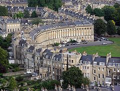
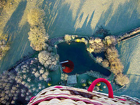
Aerial photography
Encyclopedia
Aircraft
An aircraft is a vehicle that is able to fly by gaining support from the air, or, in general, the atmosphere of a planet. An aircraft counters the force of gravity by using either static lift or by using the dynamic lift of an airfoil, or in a few cases the downward thrust from jet engines.Although...
, helicopter
Helicopter
A helicopter is a type of rotorcraft in which lift and thrust are supplied by one or more engine-driven rotors. This allows the helicopter to take off and land vertically, to hover, and to fly forwards, backwards, and laterally...
s, balloons
Balloon (aircraft)
A balloon is a type of aircraft that remains aloft due to its buoyancy. A balloon travels by moving with the wind. It is distinct from an airship, which is a buoyant aircraft that can be propelled through the air in a controlled manner....
, blimp
Blimp
A blimp, or non-rigid airship, is a floating airship without an internal supporting framework or keel. A non-rigid airship differs from a semi-rigid airship and a rigid airship in that it does not have any rigid structure, neither a complete framework nor a partial keel, to help the airbag...
s and dirigibles, rocket
Rocket
A rocket is a missile, spacecraft, aircraft or other vehicle which obtains thrust from a rocket engine. In all rockets, the exhaust is formed entirely from propellants carried within the rocket before use. Rocket engines work by action and reaction...
s, kites
Kite aerial photography
Kite aerial photography is a hobby and a type of photography. A camera is lifted using a kite and is triggered either remotely or automatically to take aerial photographs. The camera rigs can range from the extremely simple, consisting of a trigger mechanism with a disposable camera, to complex...
, poles, parachutes
Parachuting
Parachuting, also known as skydiving, is the action of exiting an aircraft and returning to earth with the aid of a parachute. It may or may not involve a certain amount of free-fall, a time during which the parachute has not been deployed and the body gradually accelerates to terminal...
, and vehicle mounted poles . Aerial photography should not be confused with Air-to-Air Photography
Air-to-air photography
Air-to-air photography is the art of photographing aircraft in the air, while using another aircraft as a photo platform. It is especially popular among military aircraft photographers and aerobatic pilots flying at air shows....
, when aircraft serve both as a photo platform and subject.
History
Aerial photography was first practiced by the French photographer and balloonist Gaspard-Félix Tournachon, known as "Nadar"Nadar (photographer)
Félix Nadar was the pseudonym of Gaspard-Félix Tournachon , a French photographer, caricaturist, journalist, novelist and balloonist. Some photographs by Nadar are marked "P. Nadar" for "Photographie Nadar" .-Life: born in April 1820 in Paris...
, in 1858 over Paris, France.
The first use of a motion picture camera mounted to a heavier-than-air aircraft took place on April 24, 1909 over Rome in the 3:28 silent film short, Wilbur Wright und seine Flugmaschine
Wilbur Wright und seine Flugmaschine
Wilbur Wright und seine Flugmaschine is the German viewing market title of a silent film made in 1909 and is considered to be the first-ever use of motion picture aerial photography as filmed from a heavier-than-air aircraft.It was filmed April 24, 1909 near Rome by French cinematographic company...
.
The first special semiautomatic aerial camera was designed in 1911 by Russian
Russians
The Russian people are an East Slavic ethnic group native to Russia, speaking the Russian language and primarily living in Russia and neighboring countries....
military engineer — Colonel Potte V. F. This aerial camera was used during World War I
World War I
World War I , which was predominantly called the World War or the Great War from its occurrence until 1939, and the First World War or World War I thereafter, was a major war centred in Europe that began on 28 July 1914 and lasted until 11 November 1918...
.
The use of aerial photography for military purposes was expanded during World War I
World War I
World War I , which was predominantly called the World War or the Great War from its occurrence until 1939, and the First World War or World War I thereafter, was a major war centred in Europe that began on 28 July 1914 and lasted until 11 November 1918...
by many other aviators such as Fred Zinn
Fred Zinn
Friedrich Wilhelm "Fred" Zinn was a volunteer American aviator who flew with French Armée de l'Air forces in World War I and an early pioneer of aerial photography for wartime reconnaissance and Military intelligence....
. One of the first notable battles was that of Neuve Chapelle
Battle of Neuve Chapelle
The Battles of Neuve Chapelle and Artois was a battle in the First World War. It was a British offensive in the Artois region and broke through at Neuve-Chapelle but they were unable to exploit the advantage.The battle began on 10 March 1915...
.
Aerial mapping came into use on the battlefronts during World
War I. In January 1918, General Allenby used five Australian pilots from No. 1 Squadron AFC
No. 1 Squadron RAAF
No. 1 Squadron is a Royal Australian Air Force squadron based at RAAF Amberley. The squadron is currently being re-equipped with F/A-18F Super Hornet multi-role fighters.-World War I:...
to photograph a 624 square miles (1,616.2 km²) area in Palestine
Palestine
Palestine is a conventional name, among others, used to describe the geographic region between the Mediterranean Sea and the Jordan River, and various adjoining lands....
as an aid to correcting and improving maps of the Turkish front. Lieutenants Leonard Taplin
Leonard Taplin
Lieutenant Leonard Thomas Eaton Taplin qualified as a flying ace during World War I. During his service in Palestine, he helped pioneer the use of aerial photography for cartography. He then transferred to the Western Front and was credited with 12 official aerial victories...
, Allan Runciman Brown
Allan Brown (aviator)
Captain Allan Runciman Brown was a World War I flying ace credited with five aerial victories. During World War II, he was a Wing Commander for the Royal Australian Air Force....
, H. L. Fraser, Edward Patrick Kenny
Edward Patrick Kenny
Lieutenant Edward Patrick Kenny was a World War I flying ace credited with seven aerial victories.-Reference:...
, and L. W. Rogers photographed a block of land stretching from the Turkish front lines 32 miles (51.5 km) deep into their rear areas. Beginning 5 January, they flew with a fighter escort to ward off enemy fighters. Using Royal Aircraft Factory BE.12 and Martinsyde
Martinsyde
Martinsyde was a British aircraft and motorcycle manufacturer between 1908 and 1922, when they were forced into liquidation by a factory fire.-History:...
airplanes, they not only overcame enemy air attacks, but also bucked 65 mile per hour winds, antiaircraft fire, and malfunctioning equipment to complete their task circa 19 January 1918.
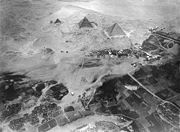
One of the most successful pioneers of the commercial use of aerial photography was by Sherman Fairchild
Sherman Fairchild
Sherman Mills Fairchild was an inventor and serial entrepreneur who founded over 70 companies namely Fairchild Aircraft, Fairchild Industries, Fairchild Aviation Corporation and Fairchild Camera and Instrument. Fairchild made significant contributions to the aviation industry and was inducted into...
who started his own aircraft firm Fairchild Aircraft to develop and build specialized aircraft for high altitude aerial survey missions. One Fairchild aerial survey aircraft in 1935 carried unit that combined two synchronized cameras, and each camera having five six inch lenses with a ten inch lenses and took photos from 23,000 feet. Each photo cover two hundred and twenty five square miles. One of its first government contracts was an aerial survey of New Mexico to study soil erosion. A year later, Fairchild introduced a better high altitude camera with nine-lens in one unit that could take a photo of 600 square miles with each exposure from 30,000 feet.
With the advent of inexpensive digital cameras, many people now take candid photographs from commercial aircraft and increasingly from general aviation
General aviation
General aviation is one of the two categories of civil aviation. It refers to all flights other than military and scheduled airline and regular cargo flights, both private and commercial. General aviation flights range from gliders and powered parachutes to large, non-scheduled cargo jet flights...
aircraft on private pleasure flights.
Uses of imagery
Cartography
Cartography is the study and practice of making maps. Combining science, aesthetics, and technique, cartography builds on the premise that reality can be modeled in ways that communicate spatial information effectively.The fundamental problems of traditional cartography are to:*Set the map's...
(particularly in photogrammetric
Photogrammetry
Photogrammetry is the practice of determining the geometric properties of objects from photographic images. Photogrammetry is as old as modern photography and can be dated to the mid-nineteenth century....
surveys
Surveying
See Also: Public Land Survey SystemSurveying or land surveying is the technique, profession, and science of accurately determining the terrestrial or three-dimensional position of points and the distances and angles between them...
, which are often the basis for topographic maps), land-use planning, archaeology
Aerial archaeology
Aerial archaeology is the study of archaeological remains by examining them from altitude.The advantages of gaining a good aerial view of the ground had been long appreciated by archaeologists as a high viewpoint permits a better appreciation of fine details and their relationships within the wider...
, movie production, environmental
Natural environment
The natural environment encompasses all living and non-living things occurring naturally on Earth or some region thereof. It is an environment that encompasses the interaction of all living species....
studies, surveillance
Surveillance
Surveillance is the monitoring of the behavior, activities, or other changing information, usually of people. It is sometimes done in a surreptitious manner...
, commercial advertising, conveyancing
Conveyancing
In law, conveyancing is the transfer of legal title of property from one person to another, or the granting of an encumbrance such as a mortgage or a lien....
, and artistic projects. In the United States, aerial photographs are used in many Phase I Environmental Site Assessment
Phase I Environmental Site Assessment
In the United States, an environmental site assessment is a report prepared for a real estate holding which identifies potential or existing environmental contamination liabilities. The analysis, often called an ESA, typically addresses both the underlying land as well as physical improvements to...
s for property analysis. Aerial photos are often processed using GIS
Geographic Information System
A geographic information system, geographical information science, or geospatial information studies is a system designed to capture, store, manipulate, analyze, manage, and present all types of geographically referenced data...
software.
Radio-controlled aircraft
Advances in radio controlled models have made it possible for model aircraftModel aircraft
Model aircraft are flying or non-flying models of existing or imaginary aircraft using a variety of materials including plastic, diecast metal, polystyrene, balsa wood, foam and fibreglass...
to conduct low-altitude aerial photography. This has benefited real-estate advertising, where commercial and residential properties are the photographic subject. Full-size, manned aircraft are prohibited from low flights above populated locations. Small scale model aircraft offer increased photographic access to these previously restricted areas. Miniature vehicles do not replace full size aircraft, as full size aircraft are capable of longer flight times, higher altitudes, and greater equipment payloads. They are, however, useful in any situation in which a full-scale aircraft would be dangerous to operate. Examples would include the inspection of transformers atop power transmission lines and slow, low-level flight over agricultural fields, both of which can be accomplished by a large-scale radio controlled helicopter. Professional-grade, gyroscopically stabilized camera platforms are available for use under such a model; a large model helicopter with a 26cc gasoline engine can hoist a payload of approximately seven kilograms (15 lbs).
Recent (2006) FAA regulations grounding all commercial RC model flights have been upgraded to require formal FAA certification before permission to fly at any altitude in USA.
Because anything capable of being viewed from a public space
Public space
A public space is a social space such as a town square that is open and accessible to all, regardless of gender, race, ethnicity, age or socio-economic level. One of the earliest examples of public spaces are commons. For example, no fees or paid tickets are required for entry, nor are the entrants...
is considered outside the realm of privacy
Privacy
Privacy is the ability of an individual or group to seclude themselves or information about themselves and thereby reveal themselves selectively...
in the United States, aerial photography may legally document features and occurrences on private property.
Oblique photographs
Photographs taken at an angle are called oblique photographs. If they are taken from a low angle earth surface–aircraft, they are called low oblique and photographs taken from a high angle are called high or steep oblique.Vertical photographs
Vertical photographs are taken straight down. They are mainly used in photogrammetry and image interpretation. Pictures that will be used in photogrammetry are traditionally taken with special large format cameras with calibratedCalibration
Calibration is a comparison between measurements – one of known magnitude or correctness made or set with one device and another measurement made in as similar a way as possible with a second device....
and documented geometric properties.
Combinations
Aerial photographs are often combined. Depending on their purpose it can be done in several ways, of which a few are listed below.- PanoramaPanoramaA panorama is any wide-angle view or representation of a physical space, whether in painting, drawing, photography, film/video, or a three-dimensional model....
s can be made by stitchingImage stitchingImage stitching or photo stitching is the process of combining multiple photographic images with overlapping fields of view to produce a segmented panorama or high-resolution image. Commonly performed through the use of computer software, most approaches to image stitching require nearly exact...
several photographs taken with one hand held camera. - In pictometryPictometryPictometry International Corp. is a Henrietta, New York-based company that provides detailed aerial photography. Its images are taken at a 40 degree angle from low-flying airplanes. Its Electronic Field Study software allows a variety of measurements to be taken directly from the image, including...
five rigidly mounted cameras provide one vertical and four low oblique pictures that can be used together. - In some digital cameras for aerial photogrammetry images from several imaging elements, sometimes with separate lenses, are geometrically corrected and combined to one image in the camera.
Orthophotos
Vertical photographs are often used to create orthophotoOrthophoto
An orthophoto, orthophotograph or orthoimage is an aerial photograph geometrically corrected such that the scale is uniform: the photo has the same lack of distortion as a map...
s, photographs which have been geometrically "corrected" so as to be usable as a map. In other words, an orthophoto is a simulation of a photograph taken from an infinite distance, looking straight down to nadir
Nadir
The nadir is the direction pointing directly below a particular location; that is, it is one of two vertical directions at a specified location, orthogonal to a horizontal flat surface there. Since the concept of being below is itself somewhat vague, scientists define the nadir in more rigorous...
. Perspective must obviously be removed, but variations in terrain should also be corrected for. Multiple geometric transformations are applied to the image, depending on the perspective and terrain corrections required on a particular part of the image.
Orthophotos are commonly used in geographic information system
Geographic Information System
A geographic information system, geographical information science, or geospatial information studies is a system designed to capture, store, manipulate, analyze, manage, and present all types of geographically referenced data...
s, such as are used by mapping agencies (e.g. Ordnance Survey
Ordnance Survey
Ordnance Survey , an executive agency and non-ministerial government department of the Government of the United Kingdom, is the national mapping agency for Great Britain, producing maps of Great Britain , and one of the world's largest producers of maps.The name reflects its creation together with...
) to create maps. Once the images have been aligned, or "registered", with known real-world coordinates, they can be widely deployed.
Large sets of orthophotos, typically derived from multiple sources and divided into "tiles" (each typically 256 x 256 pixels in size), are widely used in online map systems such as Google Maps
Google Maps
Google Maps is a web mapping service application and technology provided by Google, free , that powers many map-based services, including the Google Maps website, Google Ride Finder, Google Transit, and maps embedded on third-party websites via the Google Maps API...
. OpenStreetMap
OpenStreetMap
OpenStreetMap is a collaborative project to create a free editable map of the world. Two major driving forces behind the establishment and growth of OSM have been restrictions on use or availability of map information across much of the world and the advent of inexpensive portable GPS devices.The...
offers the use of similar orthophotos for deriving new map data. Google Earth
Google Earth
Google Earth is a virtual globe, map and geographical information program that was originally called EarthViewer 3D, and was created by Keyhole, Inc, a Central Intelligence Agency funded company acquired by Google in 2004 . It maps the Earth by the superimposition of images obtained from satellite...
overlays orthophotos or satellite imagery
Satellite imagery
Satellite imagery consists of photographs of Earth or other planets made by means of artificial satellites.- History :The first images from space were taken on sub-orbital flights. The U.S-launched V-2 flight on October 24, 1946 took one image every 1.5 seconds...
onto a digital elevation model
Digital elevation model
A digital elevation model is a digital model or 3-D representation of a terrain's surface — commonly for a planet , moon, or asteroid — created from terrain elevation data....
to simulate 3D landscapes.
Aerial video
With advancements in video technology, aerial videoAerial video
Aerial video is an emerging form of data acquisition for scene understanding and object tracking. The video is captured by low flying aerial platforms that integrate Global Positioning Systems and automated image processing to improve the accuracy and cost-effectiveness of data collection and...
is becoming more popular. Orthogonal video is shot from aircraft mapping pipelines, crop fields, and other points of interest. Using GPS, video may be embedded with meta data and later synced with a video mapping program.
This "Spatial Multimedia" is the timely union of digital media including still photography, motion video, stereo, panoramic imagery sets, immersive media constructs, audio, and other data with location and date-time information from the GPS and other location designs.
Aerial videos are emerging Spatial Multimedia which can be used for scene understanding and object tracking. The input video is captured by low flying aerial platforms and typically consists of strong parallax from non-ground-plane structures. The integration of digital video, global positioning systems (GPS) and automated image processing will improve the accuracy and cost-effectiveness of data collection and reduction. Several different aerial platforms are under investigation for the data collection.
See also
- Aerial archaeologyAerial archaeologyAerial archaeology is the study of archaeological remains by examining them from altitude.The advantages of gaining a good aerial view of the ground had been long appreciated by archaeologists as a high viewpoint permits a better appreciation of fine details and their relationships within the wider...
- Aerial landscape artAerial landscape artAerial landscape art includes paintings and other visual arts which depict or evoke the appearance of a landscape from a perspective above it—usually from a considerable distance—as it might be viewed from an aircraft or spacecraft. Sometimes the art is based not on direct observation but on aerial...
Aerial photographers category
- Airborne Real-time Cueing Hyperspectral Enhanced ReconnaissanceAirborne Real-time Cueing Hyperspectral Enhanced ReconnaissanceThe Airborne Real-time Cueing Hyperspectral Enhanced Reconnaissance, also known by the acronym ARCHER, is an aerial imaging system that produces ground images far more detailed than plain sight or ordinary aerial photography can....
- AstrocamAstrocamThe Astrocam is a model rocket with a built-in camera for taking aerial photographs.The Astrocam comes from the American manufacturer Estes and it can be flown by B6-4-and C6-7-propellants. The Astrocam was available as kit or as ready-to-fly model. The camera used 110 film and was mounted in the...
- Aviation photographyAviation photographyAviation photography is the act of capturing images of aircraft, either in flight, or on the ground. Like other specialties in photography, aviation photography requires knowledge of special techniques and of the aircraft to be done properly. There are different types of aviation photography,...
- Battle of Neuve ChapelleBattle of Neuve ChapelleThe Battles of Neuve Chapelle and Artois was a battle in the First World War. It was a British offensive in the Artois region and broke through at Neuve-Chapelle but they were unable to exploit the advantage.The battle began on 10 March 1915...
- Douglas Douglas-Hamilton, 14th Duke of HamiltonDouglas Douglas-Hamilton, 14th Duke of HamiltonAir Commodore Douglas Douglas-Hamilton, 14th Duke of Hamilton and 11th Duke of Brandon, KT, GCVO, AFC, PC, DL, FRCSE, FRGS, was a Scottish nobleman and pioneering aviator....
1932 photo flight over Mount EverestMount EverestMount Everest is the world's highest mountain, with a peak at above sea level. It is located in the Mahalangur section of the Himalayas. The international boundary runs across the precise summit point... - Fairchild K-20Fairchild K-20The K-20 is an aerial camera used during World War II. Fairchild design, made under licence for military contract. Approximately 15,000 were manufactured by Folmer Graflex Corp. in Rochester, NY between 1941-1945. They use a 5.25"x20 to 5.25"x200 foot Roll Film, with an image size of 4x5 inches...
An early aerial camera - Federal Aviation RegulationsFederal Aviation RegulationsThe Federal Aviation Regulations, or FARs, are rules prescribed by the Federal Aviation Administration governing all aviation activities in the United States. The FARs are part of Title 14 of the Code of Federal Regulations...
- GeoinformaticsGeoinformaticsGeoinformatics is the science and the technology which develops and uses information science infrastructure to address the problems of geography, geosciences and related branches of engineering.-Overview:...
- Kite aerial photographyKite aerial photographyKite aerial photography is a hobby and a type of photography. A camera is lifted using a kite and is triggered either remotely or automatically to take aerial photographs. The camera rigs can range from the extremely simple, consisting of a trigger mechanism with a disposable camera, to complex...
- National Monuments Record the public archive of English Heritage, who hold one of the largest collections of aerial photographs of England
- OracleOracle (rocket)Oracle is the name of a model rocket with built-in digital camera, manufactured by Estes Industries, for aerial photography. In contrast to the camera rocket Astrocam, the Oracle allows the making of a complete film of a rocket flight...
model photographic rocket - PictometryPictometryPictometry International Corp. is a Henrietta, New York-based company that provides detailed aerial photography. Its images are taken at a 40 degree angle from low-flying airplanes. Its Electronic Field Study software allows a variety of measurements to be taken directly from the image, including...
- Pigeon photography
- PhotogrammetryPhotogrammetryPhotogrammetry is the practice of determining the geometric properties of objects from photographic images. Photogrammetry is as old as modern photography and can be dated to the mid-nineteenth century....
- Remote sensingRemote sensingRemote sensing is the acquisition of information about an object or phenomenon, without making physical contact with the object. In modern usage, the term generally refers to the use of aerial sensor technologies to detect and classify objects on Earth by means of propagated signals Remote sensing...
- Satellite imagerySatellite imagerySatellite imagery consists of photographs of Earth or other planets made by means of artificial satellites.- History :The first images from space were taken on sub-orbital flights. The U.S-launched V-2 flight on October 24, 1946 took one image every 1.5 seconds...
- TopoFlightTopoFlightTopoFlight is a three-dimensional flight planning software that was originally conceived by a team of experts in the mapping industry, in use since 2003...
- Unmanned aerial vehicleUnmanned aerial vehicleAn unmanned aerial vehicle , also known as a unmanned aircraft system , remotely piloted aircraft or unmanned aircraft, is a machine which functions either by the remote control of a navigator or pilot or autonomously, that is, as a self-directing entity...
External links
- Aerial photography and remote sensing
- Air photo interpretation
- California Coastal Records Project
- Bird's eye view of the Delaware Valley by the Dallin Aerial Survey Company (1924–1941)
- Historic aerial photos of Columbia, South Carolina from the University of South Carolina Library
- Historical Aerial Photographs of New York , Cornell University Library & Cornell Institute for Resource Information Sciences
- National Collection of Aerial Photography The official archive of British Government declassified aerial photography.