

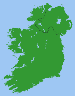
Republic of Ireland-United Kingdom border
Encyclopedia
Sovereign state
A sovereign state, or simply, state, is a state with a defined territory on which it exercises internal and external sovereignty, a permanent population, a government, and the capacity to enter into relations with other sovereign states. It is also normally understood to be a state which is neither...
s of the Republic of Ireland
Republic of Ireland
Ireland , described as the Republic of Ireland , is a sovereign state in Europe occupying approximately five-sixths of the island of the same name. Its capital is Dublin. Ireland, which had a population of 4.58 million in 2011, is a constitutional republic governed as a parliamentary democracy,...
and the United Kingdom of Great Britain and Northern Ireland
United Kingdom
The United Kingdom of Great Britain and Northern IrelandIn the United Kingdom and Dependencies, other languages have been officially recognised as legitimate autochthonous languages under the European Charter for Regional or Minority Languages...
. It is also referred to as the Irish border or – on the island of Ireland
Ireland
Ireland is an island to the northwest of continental Europe. It is the third-largest island in Europe and the twentieth-largest island on Earth...
– simply as the border (an teorainn).
The border runs for a total of 360 kilometres (223.7 mi) from Lough Foyle
Lough Foyle
Lough Foyle, sometimes Loch Foyle , is the estuary of the River Foyle in Ulster. It starts where the Foyle leaves Derry. It separates the Inishowen Peninsula in County Donegal, Republic of Ireland from County Londonderry in Northern Ireland.-Transport:...
in the north-west of the island to Carlingford Lough
Carlingford Lough
Carlingford Lough is a glacial fjord or sea inlet that forms part of the border between Northern Ireland to the north and the Republic of Ireland to the south. On its northern shore is County Down and on its southern shore is County Louth...
in the north-east (on the Irish Sea
Irish Sea
The Irish Sea separates the islands of Ireland and Great Britain. It is connected to the Celtic Sea in the south by St George's Channel, and to the Atlantic Ocean in the north by the North Channel. Anglesey is the largest island within the Irish Sea, followed by the Isle of Man...
). The only international land border in Ireland, it is inconspicuous and open by world standards, in common with many international borders in the European Union
European Union
The European Union is an economic and political union of 27 independent member states which are located primarily in Europe. The EU traces its origins from the European Coal and Steel Community and the European Economic Community , formed by six countries in 1958...
. While both states are outside the European Union's Schengen Area
Schengen Agreement
The Schengen Agreement is a treaty signed on 14 June 1985 near the town of Schengen in Luxembourg, between five of the ten member states of the European Economic Community. It was supplemented by the Convention implementing the Schengen Agreement 5 years later...
, they do share the Common Travel Area
Common Travel Area
The Common Travel Area is a passport-free zone that comprises the islands of Ireland, Great Britain, the Isle of Man and the Channel Islands. The area's internal borders are subject to minimal or non-existent border controls and can normally be crossed by Irish and British citizens with only...
, resulting in an essentially open border. Much of the border runs along the eastern edge of County Donegal
County Donegal
County Donegal is a county in Ireland. It is part of the Border Region and is also located in the province of Ulster. It is named after the town of Donegal. Donegal County Council is the local authority for the county...
.
Establishment: secession and partition
Originally intended as an internal frontier within the United Kingdom of Great Britain and IrelandUnited Kingdom of Great Britain and Ireland
The United Kingdom of Great Britain and Ireland was the formal name of the United Kingdom during the period when what is now the Republic of Ireland formed a part of it....
, the border was created in 1921 under the United Kingdom Parliament's Government of Ireland Act 1920
Government of Ireland Act 1920
The Government of Ireland Act 1920 was the Act of the Parliament of the United Kingdom which partitioned Ireland. The Act's long title was "An Act to provide for the better government of Ireland"; it is also known as the Fourth Home Rule Bill or as the Fourth Home Rule Act.The Act was intended...
. This legislated for Home Rule
Home rule
Home rule is the power of a constituent part of a state to exercise such of the state's powers of governance within its own administrative area that have been devolved to it by the central government....
in Ireland
Ireland
Ireland is an island to the northwest of continental Europe. It is the third-largest island in Europe and the twentieth-largest island on Earth...
, with separate parliaments for Southern Ireland
Southern Ireland
Southern Ireland was a short-lived autonomous region of the United Kingdom established on 3 May 1921 and dissolved on 6 December 1922.Southern Ireland was established under the Government of Ireland Act 1920 together with its sister region, Northern Ireland...
and what became Northern Ireland
Northern Ireland
Northern Ireland is one of the four countries of the United Kingdom. Situated in the north-east of the island of Ireland, it shares a border with the Republic of Ireland to the south and west...
. Six of the thirty-two counties of Ireland
Counties of Ireland
The counties of Ireland are sub-national divisions used for the purposes of geographic demarcation and local government. Closely related to the county is the County corporate which covered towns or cities which were deemed to be important enough to be independent from their counties. A county...
were assigned to Northern Ireland, and the other twenty-six to Southern Ireland.
The Anglo-Irish Treaty
Anglo-Irish Treaty
The Anglo-Irish Treaty , officially called the Articles of Agreement for a Treaty Between Great Britain and Ireland, was a treaty between the Government of the United Kingdom of Great Britain and Ireland and representatives of the secessionist Irish Republic that concluded the Irish War of...
of December 1921 led to the creation of the Irish Free State
Irish Free State
The Irish Free State was the state established as a Dominion on 6 December 1922 under the Anglo-Irish Treaty, signed by the British government and Irish representatives exactly twelve months beforehand...
, a Dominion
Dominion
A dominion, often Dominion, refers to one of a group of autonomous polities that were nominally under British sovereignty, constituting the British Empire and British Commonwealth, beginning in the latter part of the 19th century. They have included Canada, Australia, New Zealand, Newfoundland,...
established for the whole island of Ireland on 6 December 1922. The Free State was largely independent of the United Kingdom from its creation, a status formalised by the Statute of Westminster
Statute of Westminster 1931
The Statute of Westminster 1931 is an Act of the Parliament of the United Kingdom. Passed on 11 December 1931, the Act established legislative equality for the self-governing dominions of the British Empire with the United Kingdom...
in 1931. The border became an international frontier after the Parliament of Northern Ireland
Parliament of Northern Ireland
The Parliament of Northern Ireland was the home rule legislature of Northern Ireland, created under the Government of Ireland Act 1920, which sat from 7 June 1921 to 30 March 1972, when it was suspended...
exercised its right to opt out of the Free State on 7 December 1922. The 1920 border was a provisional frontier; a Boundary Commission
Boundary Commission (Ireland)
The Irish Boundary Commission was a commission which met in 1924–25 to decide on the precise delineation of the border between the Irish Free State and Northern Ireland...
met in 1924–5 to fix a permanent border between the two jurisdictions "in accordance with the wishes of the inhabitants, so far as may be compatible with economic and geographic conditions". However, its recommendations were not favoured by either side and the interim boundary was confirmed formally in 1925, without changes from the 1920 demarcation lines. The Boundary Commission report was not published until 1969. The Irish Free State was renamed Ireland
Names of the Irish state
There have been various names of the Irish state, some of which have been controversial. The constitutional name of the contemporary state is Ireland, the same as the island of Ireland, of which it comprises the major portion...
by the 1937 constitution
Constitution of Ireland
The Constitution of Ireland is the fundamental law of the Irish state. The constitution falls broadly within the liberal democratic tradition. It establishes an independent state based on a system of representative democracy and guarantees certain fundamental rights, along with a popularly elected...
, and the Republic of Ireland Act 1948 formally declared that it was a republic
Republic
A republic is a form of government in which the people, or some significant portion of them, have supreme control over the government and where offices of state are elected or chosen by elected people. In modern times, a common simplified definition of a republic is a government where the head of...
with the official description Republic of Ireland.
Customs and identity checks
Customs controls were introduced on the frontier shortly after the establishment of the Irish Free State. These controls were maintained, with varying degrees of severity, until 31 December 1992 when the European Single MarketSingle market
A single market is a type of trade bloc which is composed of a free trade area with common policies on product regulation, and freedom of movement of the factors of production and of enterprise and services. The goal is that the movement of capital, labour, goods, and services between the members...
came into effect. There are no longer any operational customs posts along either side of the border.
Whilst it has never been necessary for Irish or British citizens to produce a passport
Passport
A passport is a document, issued by a national government, which certifies, for the purpose of international travel, the identity and nationality of its holder. The elements of identity are name, date of birth, sex, and place of birth....
to cross the border, during the 1970s troubles, security forces regularly asked travellers for identification. Smaller border roads were cratered at the border to prevent people crossing; a list of "approved roads" was drawn up. In recent times (since the early 1990s) such controls have not been in operation on the border and the craters have been filled in.
In October 2007, details began to emerge of a British Government plan that might end the Common Travel Area
Common Travel Area
The Common Travel Area is a passport-free zone that comprises the islands of Ireland, Great Britain, the Isle of Man and the Channel Islands. The area's internal borders are subject to minimal or non-existent border controls and can normally be crossed by Irish and British citizens with only...
encompassing the United Kingdom and the Republic of Ireland (and also the Isle of Man and Channel Islands) in 2009, possibly creating an anomalous position for Northern Ireland in the process. In a statement to Dáil Éireann
Dáil Éireann
Dáil Éireann is the lower house, but principal chamber, of the Oireachtas , which also includes the President of Ireland and Seanad Éireann . It is directly elected at least once in every five years under the system of proportional representation by means of the single transferable vote...
, the Irish Taoiseach
Taoiseach
The Taoiseach is the head of government or prime minister of Ireland. The Taoiseach is appointed by the President upon the nomination of Dáil Éireann, the lower house of the Oireachtas , and must, in order to remain in office, retain the support of a majority in the Dáil.The current Taoiseach is...
Bertie Ahern
Bertie Ahern
Patrick Bartholomew "Bertie" Ahern is a former Irish politician who served as Taoiseach of Ireland from 26 June 1997 to 7 May 2008....
assured the House that "British authorities have no plans whatsoever to introduce any controls on the land border between North and South. I want to make that clear. All they are looking at is increased cross-border cooperation, targeting illegal immigrants." This immediately raised concerns north of the border. Jim Allister
Jim Allister
James Hugh "Jim" Allister, QC is a Northern Ireland Unionist politician and senior barrister. He is the leader of the Traditional Unionist Voice political party, serving as MLA in the Northern Ireland Assembly, where he represents Antrim North.He was formerly a member of the Democratic Unionist...
, a former member of the Democratic Unionist Party
Democratic Unionist Party
The Democratic Unionist Party is the larger of the two main unionist political parties in Northern Ireland. Founded by Ian Paisley and currently led by Peter Robinson, it is currently the largest party in the Northern Ireland Assembly and the fourth-largest party in the House of Commons of the...
and then a Member of the European Parliament
Member of the European Parliament
A Member of the European Parliament is a person who has been elected to the European Parliament. The name of MEPs differ in different languages, with terms such as europarliamentarian or eurodeputy being common in Romance language-speaking areas.When the European Parliament was first established,...
, told The Times
The Times
The Times is a British daily national newspaper, first published in London in 1785 under the title The Daily Universal Register . The Times and its sister paper The Sunday Times are published by Times Newspapers Limited, a subsidiary since 1981 of News International...
that it would be "intolerable and preposterous if citizens of the UK had to present a passport to enter another part of the UK".
Possible reinstatement of border controls announced
In July 2008, the British and Irish governments announced their intent to resume controls over their common border and the Common Travel AreaCommon Travel Area
The Common Travel Area is a passport-free zone that comprises the islands of Ireland, Great Britain, the Isle of Man and the Channel Islands. The area's internal borders are subject to minimal or non-existent border controls and can normally be crossed by Irish and British citizens with only...
in general. Each proposes to introduce detailed passport control over travellers from the other state, where travel is by air or sea. However, the land border will be 'lightly controlled'. In a joint statement, Jacqui Smith
Jacqui Smith
Jacqueline Jill "Jacqui" Smith is a member of the British Labour Party. She served as the Member of Parliament for Redditch from 1997 until 2010 and was the first ever female Home Secretary, thus making her the third woman to hold one of the Great Offices of State — after Margaret Thatcher and...
, the British Home Secretary, and Dermot Ahern
Dermot Ahern
Dermot Christopher Ahern is a former Irish Fianna Fáil politician. He was a Teachta Dála for the Louth constituency from 1987 to 2011...
, the Irish Justice Minister, said:
It is crucial that our two countries work closely together to ensure our borders are stronger than ever. Both governments fully recognise the particular circumstances of Northern Ireland. Both governments reaffirm that they have no plans to introduce fixed controls on either side of the Irish land border.
The Times reported that another consultation paper was to be published in the autumn of 2008 on whether people travelling between Northern Ireland and the rest of the United Kingdom should be subject to further checks.
One proposal is expected to suggest extending the electronic borders scheme, requiring travellers from Northern Ireland to provide their personal details in advance. This would mean residents of one part of the UK being treated differently from others when travelling within the country, something to which Unionists would object.
The Troubles
The Troubles in Northern Ireland required that attempts were made from the early 1970s until the late 1990s to enforce border controls. Many smaller cross-border roads were cratered or blockaded with the intention of making them impassable to regular traffic. Bridges were also destroyed to prevent access at unauthorised border crossings (known officially as "unapproved roads"). In particular, the border area in south County ArmaghCounty Armagh
-History:Ancient Armagh was the territory of the Ulaid before the fourth century AD. It was ruled by the Red Branch, whose capital was Emain Macha near Armagh. The site, and subsequently the city, were named after the goddess Macha...
was dominated by British Army
British Army
The British Army is the land warfare branch of Her Majesty's Armed Forces in the United Kingdom. It came into being with the unification of the Kingdom of England and Scotland into the Kingdom of Great Britain in 1707. The new British Army incorporated Regiments that had already existed in England...
surveillance posts. Derry
Derry
Derry or Londonderry is the second-biggest city in Northern Ireland and the fourth-biggest city on the island of Ireland. The name Derry is an anglicisation of the Irish name Doire or Doire Cholmcille meaning "oak-wood of Colmcille"...
, the second-largest city in Northern Ireland, is close to the border with County Donegal
County Donegal
County Donegal is a county in Ireland. It is part of the Border Region and is also located in the province of Ulster. It is named after the town of Donegal. Donegal County Council is the local authority for the county...
. This meant that there was a heavy security presence around the city, often impeding traffic and general movement between Derry City and County Donegal. Despite these measures, the border was simply too long and had too many minor access roads to enable control of the majority of cross-border movements. In any case, authorised crossing-points on the border remained open to civilian traffic in both directions at all times although vehicles and their occupants were subject to detailed searches while some crossing points were closed to vehicle traffic at night when customs posts were unstaffed.
Difficulty in patrolling parts of the border and large taxation/currency differences (particularly during the 1980s) led to widespread smuggling. However, greater European integration has led to roughly similar tax rates on most items and easing of restrictions on cross-border trade. Smuggling nowadays is mostly limited to fuel, livestock and a seasonal trade in illegal fireworks (which are strictly regulated in the Republic).
While it still exists, the border now creates fewer impediments than before. This has been mainly due to the Common Travel Area
Common Travel Area
The Common Travel Area is a passport-free zone that comprises the islands of Ireland, Great Britain, the Isle of Man and the Channel Islands. The area's internal borders are subject to minimal or non-existent border controls and can normally be crossed by Irish and British citizens with only...
between the Republic of Ireland and the United Kingdom, as well as a sharp reduction in cross-border activity by paramilitaries
Paramilitary
A paramilitary is a force whose function and organization are similar to those of a professional military, but which is not considered part of a state's formal armed forces....
. EU integration has also played a part. Following the Northern Ireland peace process
Northern Ireland peace process
The peace process, when discussing the history of Northern Ireland, is often considered to cover the events leading up to the 1994 Provisional Irish Republican Army ceasefire, the end of most of the violence of the Troubles, the Belfast Agreement, and subsequent political developments.-Towards a...
, military surveillance has been replaced by PSNI
Police Service of Northern Ireland
The Police Service of Northern Ireland is the police force that serves Northern Ireland. It is the successor to the Royal Ulster Constabulary which, in turn, was the successor to the Royal Irish Constabulary in Northern Ireland....
patrols.
Border settlements
The following cities, towns and villages are located on the border or not far from it (listed from Lough FoyleLough Foyle
Lough Foyle, sometimes Loch Foyle , is the estuary of the River Foyle in Ulster. It starts where the Foyle leaves Derry. It separates the Inishowen Peninsula in County Donegal, Republic of Ireland from County Londonderry in Northern Ireland.-Transport:...
to Carlingford Lough
Carlingford Lough
Carlingford Lough is a glacial fjord or sea inlet that forms part of the border between Northern Ireland to the north and the Republic of Ireland to the south. On its northern shore is County Down and on its southern shore is County Louth...
):
- GreencastleGreencastle, County DonegalGreencastle, County Donegal , is a commercial fishing port located in the north of the scenic Inishowen Peninsula on the north coast of County Donegal, part of the Province of Ulster, in the northwest of Ireland. Nowadays, given the decline in the fishing industry, it resembles more closely a...
, InishowenInishowenInishowen is a peninsula in County Donegal, part of the Province of Ulster in the north of Ireland. It is also the largest peninsula in all of Ireland. Inishowen is a picturesque location with a rich history...
, County DonegalCounty DonegalCounty Donegal is a county in Ireland. It is part of the Border Region and is also located in the province of Ulster. It is named after the town of Donegal. Donegal County Council is the local authority for the county... - MuffMuff, County DonegalMuff is a village in County Donegal, Ireland. It is near the mouth of the River Foyle and sits at the border between the Republic of Ireland and Northern Ireland. The village of Culmore and the city of Derry are to the south...
, Inishowen, County Donegal - CulmoreCulmoreCulmore is a village and townland in County Londonderry, Northern Ireland. It is between Derry and Muff, at the mouth of the River Foyle. In the 2001 Census it had a population of 2,960 people.- History :...
, County LondonderryCounty LondonderryThe place name Derry is an anglicisation of the old Irish Daire meaning oak-grove or oak-wood. As with the city, its name is subject to the Derry/Londonderry name dispute, with the form Derry preferred by nationalists and Londonderry preferred by unionists... - DerryDerryDerry or Londonderry is the second-biggest city in Northern Ireland and the fourth-biggest city on the island of Ireland. The name Derry is an anglicisation of the Irish name Doire or Doire Cholmcille meaning "oak-wood of Colmcille"...
, County Londonderry - Killea, County Donegal
- NewtowncunninghamNewtowncunninghamNewtown Cunningham , sometimes spelled Newtowncunningham or abbreviated to Newton , is a village in The Laggan district in the east of County Donegal, Ireland. Located on the N13 road 18 km east of Letterkenny and 16 km west of Derry, it is ideally located as a commuter village for both...
, County Donegal - CarrigansCarrigansCarrigans is a village in The Laggan, a district in the east of County Donegal, part of the Province of Ulster in Ireland. The village is located only a short distance from the River Foyle on the R236 regional road....
, County Donegal - St. JohnstonSt JohnstonSt Johnston is a village in County Donegal, part of the Province of Ulster in Ireland. The village is located on the west bank of the River Foyle, in The Laggan district of East Donegal, on the R236 regional road.-See also:* St Johnston Cricket Club...
, County Donegal - LiffordLiffordLifford is the county town of County Donegal, Ireland. It is the administrative capital of the county and the seat of Donegal County Council, although the town of Letterkenny is often mistaken for fulfilling this role...
, County Donegal (linked to Strabane by Lifford BridgeLifford BridgeLifford Bridge is a cross-border bridge on the N15 - A38 road, spanning the River Foyle which marks the border between Strabane in County Tyrone, Northern Ireland, and Lifford in County Donegal in the Republic of Ireland....
) - StrabaneStrabaneStrabane , historically spelt Straban,is a town in west County Tyrone, Northern Ireland. It contains the headquarters of Strabane District Council....
, County TyroneCounty TyroneHistorically Tyrone stretched as far north as Lough Foyle, and comprised part of modern day County Londonderry east of the River Foyle. The majority of County Londonderry was carved out of Tyrone between 1610-1620 when that land went to the Guilds of London to set up profit making schemes based on...
(linked to Lifford by Lifford Bridge) - CladyClady, County TyroneClady is a small village in County Tyrone, Northern Ireland, about 4 miles from Strabane, on the River Finn and the border with County Donegal in the Republic of Ireland. In the 2001 Census it had a population of 423 people. In 1842 the population was 176...
, County Tyrone - Castlefin, County Donegal
- CastledergCastledergCastlederg is a village in County Tyrone, Northern Ireland. It lies on the River Derg and is close to the border with County Donegal. The village has a ruined castle and two ancient tombs known as the Druid's Altar and Todd's Den...
, County Tyrone - KilleterKilleterKilleter is a small village and townland near Castlederg in County Tyrone, Northern Ireland. In the 2001 Census it had a population of 147.Killeter has a yearly August fair, which celebrates the diversity and richness of rural life. The village itself sits along an ancient pilgrimage trail which...
, County Tyrone - PettigoPettigoPettigo is a small village on the border of County Donegal, Republic of Ireland and County Fermanagh, Northern Ireland. It is bisected by the Termon River which is part of the border between the Republic of Ireland and Northern Ireland...
, County Donegal and TullyhommonTullyhommonTullyhommon is a small village in County Fermanagh, Northern Ireland. It lies within the Fermanagh District Council area. In the 2001 Census the village had a population of 81 people....
, County FermanaghCounty FermanaghFermanagh District Council is the only one of the 26 district councils in Northern Ireland that contains all of the county it is named after. The district council also contains a small section of County Tyrone in the Dromore and Kilskeery road areas....
(separated by a river) - BallyshannonBallyshannonBallyshannon is a town in County Donegal, Ireland. It is located where the N3 and N15 cross the River Erne, and claims to be the oldest town in Ireland.-Location:...
, County Donegal - BundoranBundoranBundoran is a town in County Donegal, part of the Province of Ulster in the north of Ireland. The town is located on the N15 road near Ballyshannon, 3 hours drive from Dublin and around two and a quarter hours drive from Belfast...
, County Donegal - BelleekBelleek, County FermanaghBelleek is a village in County Fermanagh, Northern Ireland. While the greater part of the village lies within County Fermanagh, part of it crosses the border into County Donegal, a part of Ulster that lies in the Republic of Ireland. This makes Belleek the western-most village in the United Kingdom...
, County Fermanagh (part of Belleek is actually in County DonegalCounty DonegalCounty Donegal is a county in Ireland. It is part of the Border Region and is also located in the province of Ulster. It is named after the town of Donegal. Donegal County Council is the local authority for the county...
, as the border passes through the town but most of it is on the 'northern' side) - KiltyclogherKiltyclogherKiltyclogher is a small village in County Leitrim, Ireland. It is on the border with Fermanagh, however two of the connecting roads were blocked by the British authorities during the Troubles of the late 20th century - these have since been re-opened, however the town was isolated during the...
, County LeitrimCounty LeitrimCounty Leitrim is a county in Ireland. It is located in the West Region and is also part of the province of Connacht. It is named after the village of Leitrim. Leitrim County Council is the local authority for the county... - BlacklionBlacklionBlacklion is a border village in west County Cavan, Ireland. It is situated on the N16 national primary road, just across the border from the County Fermanagh village of Belcoo.- History :The village is within the townland of Tuam...
, County CavanCounty CavanCounty Cavan is a county in Ireland. It is part of the Border Region and is also located in the province of Ulster. It is named after the town of Cavan. Cavan County Council is the local authority for the county...
and - BelcooBelcooBelcoo is a small village and townland in County Fermanagh, Northern Ireland, 10 miles from Enniskillen. It is on the County Fermanagh/County Cavan border beside the village of Blacklion in the Republic of Ireland...
, County Fermanagh (linked to Blacklion by bridge) - SwanlinbarSwanlinbarSwanlinbar is a small village on the N87 national secondary road in north-west County Cavan, Ireland, close to the Cladagh river and near the Fermanagh border.The village is in the barony of Tullyhaw....
, County Cavan - BallyconnellBallyconnellBallyconnell is a town in County Cavan, Ireland. It is situated on the N87 national secondary road at the junction of four townlands Annagh, Cullyleenan, Doon and Derryginny in the parish of Tomregan, Barony of Tullyhaw. The town has an altitude of 55 metres above sea level...
, County Cavan - ScotshouseScotshouseScotshouse is a small agricultural village about away from the border town of Clones, in County Monaghan, Republic of Ireland.It is close to the border with both County Cavan and County Fermanagh...
, County MonaghanCounty MonaghanCounty Monaghan is a county in Ireland. It is part of the Border Region and is also located in the province of Ulster. It is named after the town of Monaghan. Monaghan County Council is the local authority for the county... - NewtownbutlerNewtownbutlerNewtownbutler or Newtown Butler is a small village in County Fermanagh, Northern Ireland. It is in the southeast corner of the County, close to the border with County Monaghan and the town of Clones. It is surrounded by small lakes and bogland and close to Lough Erne...
, County Fermanagh - ClonesClonesClones is a small town in western County Monaghan, in the 'border area' of the Republic of Ireland. The area is part of the Border Region, earmarked for economic development by the Irish Government due to its currently below-average economic situation...
, County Monaghan - Aughnacloy, County Tyrone
- GlasloughGlasloughGlaslough is a village and townland in the north of County Monaghan, Ireland, on the R185 regional road south of the border with Northern Ireland and northeast of Monaghan Town. Glaslough won the Irish Tidy Towns Competition in 1978. Castle Leslie, the large Victorian country house and luxury...
, County Monaghan - CaledonCaledon, County TyroneCaledon , historically known as Kinnaird , is a small village and townland in County Tyrone, Northern Ireland. It is in the Clogher Valley on the banks of the River Blackwater, 7 miles from Armagh. It lies in the southeast of Tyrone and near the borders of County Armagh and County Monaghan. In the...
, County Tyrone - MiddletownMiddletown, County ArmaghMiddletown is a small village and townland in County Armagh, Northern Ireland. It lies two miles from Tynan and close to the border with County Monaghan. In the 2001 Census it had a population of 240 people...
, County ArmaghCounty Armagh-History:Ancient Armagh was the territory of the Ulaid before the fourth century AD. It was ruled by the Red Branch, whose capital was Emain Macha near Armagh. The site, and subsequently the city, were named after the goddess Macha... - CullavilleCullavilleCullaville or Culloville is a small village and townland near Crossmaglen in County Armagh, Northern Ireland. It is the southernmost settlement in the county and one of the southernmost in Northern Ireland, straddling the Irish border. In the 2001 Census it had a population of 400 people...
, County Armagh - ForkhillForkhillForkhill or Forkill is a small village in south County Armagh, Northern Ireland. It is within the Ring of Gullion, near Slieve Fuad. In the 2001 Census it had a population of 366.- Name :...
, County Armagh - DundalkDundalkDundalk is the county town of County Louth in Ireland. It is situated where the Castletown River flows into Dundalk Bay. The town is close to the border with Northern Ireland and equi-distant from Dublin and Belfast. The town's name, which was historically written as Dundalgan, has associations...
, County LouthCounty LouthCounty Louth is a county of Ireland. It is part of the Border Region and is also located in the province of Leinster. It is named after the town of Louth. Louth County Council is the local authority for the county... - Jonesborough, County Armagh
- NewryNewryNewry is a city in Northern Ireland. The River Clanrye, which runs through the city, formed the historic border between County Armagh and County Down. It is from Belfast and from Dublin. Newry had a population of 27,433 at the 2001 Census, while Newry and Mourne Council Area had a population...
, County Armagh/County DownCounty Down-Cities:*Belfast *Newry -Large towns:*Dundonald*Newtownards*Bangor-Medium towns:... - WarrenpointWarrenpointWarrenpoint is a small town in County Down, Northern Ireland. It lies on the northern shore of Carlingford Lough and is separated from the Republic of Ireland by a narrow strait. The town sprang up within the townland of Ringmackilroy...
, County Down - OmeathOmeathOmeath is a village on the R173 regional road in County Louth, Ireland, close to the border with Northern Ireland. It is roughly mid way between Dublin and Belfast, very near the County Louth and County Armagh / County Down border. Omeath has a population of 439, and is approximately from...
, County Louth
Since ferry serives between Omeath and Warrenpoint have recently resumed (and the recently proposed construction of a new bridge) it is hoped that there will be revived interaction between the two sides of the lough since these two towns are 20 km (12.4 mi) apart by road.
Ongoing maritime border demarcation dispute
The exact division of territorial waters between Northern Ireland and Southern IrelandSouthern Ireland
Southern Ireland was a short-lived autonomous region of the United Kingdom established on 3 May 1921 and dissolved on 6 December 1922.Southern Ireland was established under the Government of Ireland Act 1920 together with its sister region, Northern Ireland...
('Southern Ireland' being coterminous with the territory of the modern-day Irish state) was a matter of some controversy from the outset. Section 1(2) of the Government of Ireland Act 1920 defined the respective territories of Northern Ireland and the then Southern Ireland as follows:
At the time of that Act, both Northern Ireland and Southern Ireland were to remain parts of the United Kingdom. Perhaps because of this, the Act did not explicitly address the position of territorial waters although Section 11(4) provided that neither Southern Ireland or Northern Ireland would have any competence to make laws in respect of “Lighthouses, buoys, or beacons (except so far as they can consistently with any general Act of the Parliament of the United Kingdom be constructed or maintained by a local harbour authority)”.
When the territory that initially was Southern Ireland ultimately became a separate self-governing dominion outside the United Kingdom known as the Irish Free State
Irish Free State
The Irish Free State was the state established as a Dominion on 6 December 1922 under the Anglo-Irish Treaty, signed by the British government and Irish representatives exactly twelve months beforehand...
, the status of the territorial waters naturally took on a significance it had not had before. Northern Ireland's Unionists were conscious of this matter from an early stage. They were keen to put it beyond doubt that the territorial waters around Northern Ireland would not belong to the Irish Free State. In this regard, James Craig
James Craig, 1st Viscount Craigavon
James Craig, 1st Viscount Craigavon, PC, PC , was a prominent Irish unionist politician, leader of the Ulster Unionist Party and the first Prime Minister of Northern Ireland...
, the Prime Minister of Northern Ireland
Prime Minister of Northern Ireland
The Prime Minister of Northern Ireland was the de facto head of the Government of Northern Ireland. No such office was provided for in the Government of Ireland Act 1920. However the Lord Lieutenant, as with Governors-General in other Westminster Systems such as in Canada, chose to appoint someone...
put the following question in the British House of Commons on 27 November 1922 (the month before the establishment of the Irish Free State):
In response the Attorney General, Sir Douglas Hogg, said that “I have considered the question, and I have given an opinion that that is so [i.e. the territorial waters do go with the counties]".
However, this interpretation that the territorial waters went with the counties was later disputed by Irish Governments. A good summary of the Irish position was given by the then Taoiseach, Jack Lynch
Jack Lynch
John Mary "Jack" Lynch was the Taoiseach of Ireland, serving two terms in office; from 1966 to 1973 and 1977 to 1979....
, during a Dáil debate on 29 February 1972:
A particular dispute arose between the Government of the Irish Free State of the one part and the Northern Ireland and UK governments of the other part over territorial waters in Lough Foyle
Lough Foyle
Lough Foyle, sometimes Loch Foyle , is the estuary of the River Foyle in Ulster. It starts where the Foyle leaves Derry. It separates the Inishowen Peninsula in County Donegal, Republic of Ireland from County Londonderry in Northern Ireland.-Transport:...
. Lough Foyle lies between County Londonderry
County Londonderry
The place name Derry is an anglicisation of the old Irish Daire meaning oak-grove or oak-wood. As with the city, its name is subject to the Derry/Londonderry name dispute, with the form Derry preferred by nationalists and Londonderry preferred by unionists...
in Northern Ireland and County Donegal
County Donegal
County Donegal is a county in Ireland. It is part of the Border Region and is also located in the province of Ulster. It is named after the town of Donegal. Donegal County Council is the local authority for the county...
in the then Irish Free State. A court case in the Free State in 1923 relating to fishing rights in Lough Foyle held that the Free State’s territorial waters ran right up to the shore of County Londonderry. In 1927, illegal fishing on Lough Foyle had become so grave that Northern Ireland Prime Minister James Craig entered into correspondence with his Free State counterpart, W. T. Cosgrave. Craig indicated to Cosgrave that he proposed to introduce a Bill giving the Royal Ulster Constabulary
Royal Ulster Constabulary
The Royal Ulster Constabulary was the name of the police force in Northern Ireland from 1922 to 2000. Following the awarding of the George Cross in 2000, it was subsequently known as the Royal Ulster Constabulary GC. It was founded on 1 June 1922 out of the Royal Irish Constabulary...
powers to stop and search vessels on Lough Foyle. Cosgrave asserted all of Lough Foyle was Free State territory and that as such a Bill of that nature would be rejected by the Free State and its introduction would create “a very serious situation”. Cosgrave then raised the matter with the British government.
It appears that the territorial waters generally are no longer disputed between the two states but the maritime boundary
Maritime boundary
Maritime boundary is a conceptual means of division of the water surface of the planet into maritime areas that are defined through surrounding physical geography or by human geography. As such it usually includes areas of exclusive national rights over the mineral and biological resources,...
dispute between Ireland and the United Kingdom concerning Lough Foyle (and similarly Carlingford Lough
Carlingford Lough
Carlingford Lough is a glacial fjord or sea inlet that forms part of the border between Northern Ireland to the north and the Republic of Ireland to the south. On its northern shore is County Down and on its southern shore is County Louth...
) may still not have been settled. As recently as 2005, when asked to list those areas of EU member states where border definition is in dispute, a British Government minister responding for the Secretary of State for Foreign and Commonwealth Affairs
Secretary of State for Foreign and Commonwealth Affairs
The Secretary of State for Foreign and Commonwealth Affairs, commonly referred to as the Foreign Secretary, is a senior member of Her Majesty's Government heading the Foreign and Commonwealth Office and regarded as one of the Great Offices of State...
stated: "Border definition (ie the demarcation of borders between two internationally recognised sovereign states with an adjoining territorial or maritime border) is politically disputed [between] Ireland [and the] UK (Lough Foyle, Carlingford Lough—quiescent)" It appears moves have been made on the Irish side to settle the issue. During Dáil debates on the Carlingford Fisheries Bill, a contributor to the debate stated that he welcomed "the Bill’s aim of defining the area of jurisdiction over the Foyle." However, it appears that the Carlingford Fisheries Act 2007 ultimately remained silent on the point.
Identifying the border
Road signs in the Republic of Ireland
Road signs in Ireland mostly differ from the traffic signs used elsewhere in Europe. Directional signage is similar to that of the United Kingdom, but is bilingual. Distances are in kilometres. Apart from directional signage, the basic prohibitory signs such as "no left turn" and "no right turn"...
are mostly black/yellow and diamond shaped (similar to those in North America
North America
North America is a continent wholly within the Northern Hemisphere and almost wholly within the Western Hemisphere. It is also considered a northern subcontinent of the Americas...
and Australasia
Australasia
Australasia is a region of Oceania comprising Australia, New Zealand, the island of New Guinea, and neighbouring islands in the Pacific Ocean. The term was coined by Charles de Brosses in Histoire des navigations aux terres australes...
) whereas those in the UK
Road signs in the United Kingdom
Road signs in the United Kingdom conform broadly to European norms, though a number of signs are unique to Britain and direction signs omit European route numbers.-History:...
are mainly black/white/red triangles or circles (the same as the rest of the European Union
European Union
The European Union is an economic and political union of 27 independent member states which are located primarily in Europe. The EU traces its origins from the European Coal and Steel Community and the European Economic Community , formed by six countries in 1958...
).
By rail, there is no immediate sign of crossing the border, but the trackside mileage markers change from Irish-style markers at the 59¾-mile post (from Dublin Connolly railway station
Dublin Connolly railway station
Dublin Connolly, commonly called Connolly station , is one of the main railway stations in Dublin, Ireland, and is a focal point in the Irish route network. Opened in 1844 as Amiens Street Station, the ornate facade has a distinctive Italianate tower at its centre...
) to black-on-yellow markers, common to the rest of the United Kingdom, at the 60 miles (96.6 km) post, between Dundalk
Dundalk railway station
Dundalk Clarke railway station serves Dundalk in County Louth, Ireland. It consists of an island platform, with a bay facing south. It is served by the Dublin-Belfast "Enterprise" express trains as well as local Commuter services to and from Dublin...
and Newry
Newry railway station
Newry railway station serves Newry in Northern Ireland. The station is in the northwest of the town on the Cross Border line next to the 18-arch, high Craigmore Viaduct....
stations.
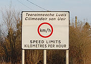
Since the adoption by the Republic of metric
Metric system
The metric system is an international decimalised system of measurement. France was first to adopt a metric system, in 1799, and a metric system is now the official system of measurement, used in almost every country in the world...
speed limits, warning signs have been placed on either side of the border to alert motorists to the change to or from miles
Miles per hour
Miles per hour is an imperial unit of speed expressing the number of statute miles covered in one hour. It is currently the standard unit used for speed limits, and to express speeds generally, on roads in the United Kingdom and the United States. It is also often used to express the speed of...
or kilometres per hour
Kilometres per hour
The kilometre per hour is a unit of speed, expressing the number of kilometres traveled in one hour. The unit symbol is km/h or km·h−1....
. As the United Kingdom does not use the euro
Euro
The euro is the official currency of the eurozone: 17 of the 27 member states of the European Union. It is also the currency used by the Institutions of the European Union. The eurozone consists of Austria, Belgium, Cyprus, Estonia, Finland, France, Germany, Greece, Ireland, Italy, Luxembourg,...
, advertised prices for service stations and shops will change currency on crossing, although many places along the border will accept cross-border currency informally (albeit usually at a rate favourable to the trader).
Other typical signs of crossing a European border are also noticeable. These include subtle differences in the paving materials of road surfaces and sidewalks, sometimes with visible differences in color between materials across the border (though these also vary across intra-county borders), changes in the colour of postboxes (green in the Republic, red in Northern Ireland). Likewise, language differences between the two jurisdictions will mark a change from one to the other (Signs in the Republic commonly carry Irish as well as English text). Signs have subtle difference in colouring and fonts.
Mobile phone roaming charges
As in most places, radio signals from the cellular networks on both of the border sides often travel several kilometres across it. This is a source of annoyance to those resident in border areas as roamingRoaming
In wireless telecommunications, roaming is a general term referring to the extension of connectivity service in a location that is different from the home location where the service was registered. Roaming ensures that the wireless device is kept connected to the network, without losing the...
charges are incurred with most service providers if the phone connects to the "wrong" network when making or even receiving a call. It is believed that one third of mobile phone users in Northern Ireland have been affected by this. Discussion between the relevant communication regulators in the two jurisdictions is under way in an attempt to resolve the issue with Irish operator Meteor
Meteor Mobile Communications
Meteor Mobile Communications Limited, a part of eircom, is a GSM and UMTS mobile telecommunications company in Ireland. They operate a GSM/GPRS/EDGE/UMTS cellular communications network under licence from the Commission for Communications Regulation , and were the third entrant in the market, after...
abolishing charges for receiving calls in Northern Ireland, once their customers roam on T-Mobile
T-Mobile
T-Mobile International AG is a German-based holding company for Deutsche Telekom AG's various mobile communications subsidiaries outside Germany. Based in Bonn, Germany, its subsidiaries operate GSM and UMTS-based cellular networks in Europe, the United States, Puerto Rico and the US Virgin Islands...
there, and creating a special Northern Ireland roaming tariff for both Post and Prepay customers. O2 Ireland are also introducing an "all Ireland tariff". UK mobile networks have yet to provide this service to their Northern Ireland customers.
See also
- British–Irish relations
- Foreign relations of the United KingdomForeign relations of the United KingdomThe diplomatic foreign relations of the United Kingdom are implemented by the United Kingdom's Foreign and Commonwealth Office. The UK was the world's foremost power during the 19th and early 20th centuries. Throughout history it has wielded significant influence upon other nations via the British...
- Foreign relations of the Republic of IrelandForeign relations of the Republic of IrelandThe foreign relations of Ireland are substantially influenced by its membership of the European Union, although bilateral relations with the United States and United Kingdom are also important to the country. It is one of the group of smaller nations in the EU, and has traditionally followed a...
- Irish nationality lawIrish nationality lawIrish nationality law is the law of the Republic of Ireland governing citizenship. A person may be an Irish citizen through birth, descent, marriage to an Irish citizen or through naturalisation. Irish nationality law is currently contained in the provisions of the Irish Nationality and Citizenship...
- British nationality lawBritish nationality lawBritish nationality law is the law of the United Kingdom that concerns citizenship and other categories of British nationality. The law is complex because of the United Kingdom's former status as an imperial power.-History:...
- British nationality law and the Republic of IrelandBritish nationality law and the Republic of IrelandThis article concerns British nationality law in respect of citizens of what is now the independent state of Ireland, which was known in the United Kingdom as "Eire" between 1937 and 1949, and which was the Irish Free State between 1922 and 1937...
- Common Travel AreaCommon Travel AreaThe Common Travel Area is a passport-free zone that comprises the islands of Ireland, Great Britain, the Isle of Man and the Channel Islands. The area's internal borders are subject to minimal or non-existent border controls and can normally be crossed by Irish and British citizens with only...
- Foreign relations of the United Kingdom
- Repartition of IrelandRepartition of IrelandThe repartition of Ireland has been suggested as a possible solution to the Troubles. It implies that the essential problem was that the partition of Ireland was gerrymandered, and as a result Northern Ireland contains a large Irish nationalist minority...
- PartitionismPartitionismIn Ireland, partitionism refers to views on Irish politics, culture, geography or history that treat Northern Ireland and the Republic of Ireland as distinct. Partitionists may emphasise the perceived differences between the two jurisdictions and the people who live within them...
External links
- Centre for Cross Border Studies - researches and develops cooperation across the Irish border in education, training, health, business, public administration, communications, agriculture and the environment, and acts as secretariat for a number of cross-border educational organisations.
- "Border Ireland" - an information portal on cross-border co-operation on the island of Ireland since 1990 including a searchable database of cross-border activities, publications, organisations and funding, a series of critical briefing papers and an up-to-date media centre of cross-border issues in the national and regional press.
- "Mapping Frontiers" (a cross-border research project between UCD and QUB specifically about the Irish border)
- "Border People" - cross-border mobility portal with four main themes - Commute, Work, Live, Study
- Popular ferry back in action
- A Nameless Intra-Irish Pene-Enclave