
Carlingford Lough
Encyclopedia
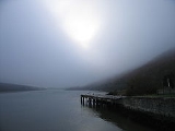
Carlingford Lough is a glacial fjord
or sea inlet
that forms part of the border between Northern Ireland
to the north and the Republic of Ireland
to the south. On its northern shore is County Down
and on its southern shore is County Louth
. At its extreme interior angle (the northwest corner) it is fed by the Newry River
and the Newry Canal
.
The inlet is named after the village of Carlingford, County Louth
. Historically it was called Cuan Snámh-Aighneach, Snámh-Aighneach or Cuan Cairlinne in Irish. An older English name was Nury (Newry
) Bay.
and the Newry Canal
link the Lough to the nearby city of Newry
(the Canal continues on towards the River Bann
and Lough Neagh
; the river, under the name River Clanrye, loops around County Down). The only other known glacial fjords in Ireland are Lough Swilly
and Killary Harbour
.
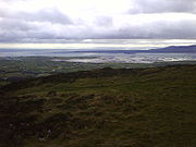
On the northern side, in County Down
, are the coastal towns of Warrenpoint
and Rostrevor
, backed by the Mourne Mountains. On the southern coast are Omeath
, Carlingford
and Greenore
backed by the Cooley Mountains
, all on the Cooley Peninsula
in County Louth
.
On 3 November 1916 two steamers, the SS Connemara
and the SS Retriever, collided and sank in the loch with the loss of ninety-four lives. In the late 1980s Charles Haughey
, the then Irish Taoiseach sailed his yacht into Carlingford Lough and raised an Irish Tri Colour
. As Carlingford Lough is half in the U.K., the Royal Navy
thought he was in the U.K. and believed he was a Republican
, and grew suspicious. They pursued him. As they left dock, the Taoiseach realised what was happening. He called in the re-enforcements of Irish Navy ship LÉ Eithne, which was close by. Eithne sailed to the mouth of the Lough and stopped, effectively barricading the Royal Navy gunboat.
and yacht
ing. Lough cruises are now a regular feature during the summer months.
es which provide winter feeding areas for the Pale-bellied Brent Goose, Branta bernicla hrota. At the mouth of the lough are several small rock and shingle islands which are breeding areas for tern
s that feed in its shallow waters.
 The Carlingford Lough Ramsar site (wetlands of international importance designated under the Ramsar Convention
), is 830.51 hectares in area, at Latitude 54 03 00 N and Longitude 06 07 00 W. It was designated a Ramsar site on 9 March 1998. It is a cross-border site. The northern shore is in Northern Ireland and includes the most significant mudflats in the lough, and an area of salt marsh
. The southern shore is in the republic of Ireland. At the mouth of the lough are several small rock and shingle islands which are of importance to tern
s.
The Ramsar Site lies between Killowen Point and Soldiers Point on the northern shores of Carlingford Lough and the landward boundary coincides entirely with that of the Carlingford Lough Area of Special Scientific Interest
and the Carlingford Lough Special Protection Area
.
The site qualified under Criterion 2 of the Ramsar Convention
because it supports important groups of vulnerable and endangered Irish Red Data Book bird species. It supports nationally important breeding populations of Common Tern
. Roseate Tern
s returned to the site after an absence of six years with two breeding pairs recorded in 1997. It has also supported nationally important numbers of Arctic Tern
. It also qualified under Criterion 3c for supporting internationally important breeding populations of Sandwich Tern and of overwintering Light-bellied Brent Geese
.
Fjord
Geologically, a fjord is a long, narrow inlet with steep sides or cliffs, created in a valley carved by glacial activity.-Formation:A fjord is formed when a glacier cuts a U-shaped valley by abrasion of the surrounding bedrock. Glacial melting is accompanied by rebound of Earth's crust as the ice...
or sea inlet
Inlet
An inlet is a narrow body of water between islands or leading inland from a larger body of water, often leading to an enclosed body of water, such as a sound, bay, lagoon or marsh. In sea coasts an inlet usually refers to the actual connection between a bay and the ocean and is often called an...
that forms part of the border between Northern Ireland
Northern Ireland
Northern Ireland is one of the four countries of the United Kingdom. Situated in the north-east of the island of Ireland, it shares a border with the Republic of Ireland to the south and west...
to the north and the Republic of Ireland
Republic of Ireland
Ireland , described as the Republic of Ireland , is a sovereign state in Europe occupying approximately five-sixths of the island of the same name. Its capital is Dublin. Ireland, which had a population of 4.58 million in 2011, is a constitutional republic governed as a parliamentary democracy,...
to the south. On its northern shore is County Down
County Down
-Cities:*Belfast *Newry -Large towns:*Dundonald*Newtownards*Bangor-Medium towns:...
and on its southern shore is County Louth
County Louth
County Louth is a county of Ireland. It is part of the Border Region and is also located in the province of Leinster. It is named after the town of Louth. Louth County Council is the local authority for the county...
. At its extreme interior angle (the northwest corner) it is fed by the Newry River
Newry River
Newry River and River Clanrye are names for one of the rivers of Ireland; it passes through the city of Newry and empties into Carlingford Lough near Warrenpoint...
and the Newry Canal
Newry Canal
The Newry Canal, located in Northern Ireland, was built to link the Tyrone coalfields to the Irish Sea at Carlingford Lough near Newry.-History:...
.
The inlet is named after the village of Carlingford, County Louth
Carlingford, County Louth
Carlingford is a coastal town and townland in northern County Louth, Ireland. It is situated between Carlingford Lough and Slieve Foy, sometimes known as Carlingford Mountain...
. Historically it was called Cuan Snámh-Aighneach, Snámh-Aighneach or Cuan Cairlinne in Irish. An older English name was Nury (Newry
Newry
Newry is a city in Northern Ireland. The River Clanrye, which runs through the city, formed the historic border between County Armagh and County Down. It is from Belfast and from Dublin. Newry had a population of 27,433 at the 2001 Census, while Newry and Mourne Council Area had a population...
) Bay.
Geography
The Newry RiverNewry River
Newry River and River Clanrye are names for one of the rivers of Ireland; it passes through the city of Newry and empties into Carlingford Lough near Warrenpoint...
and the Newry Canal
Newry Canal
The Newry Canal, located in Northern Ireland, was built to link the Tyrone coalfields to the Irish Sea at Carlingford Lough near Newry.-History:...
link the Lough to the nearby city of Newry
Newry
Newry is a city in Northern Ireland. The River Clanrye, which runs through the city, formed the historic border between County Armagh and County Down. It is from Belfast and from Dublin. Newry had a population of 27,433 at the 2001 Census, while Newry and Mourne Council Area had a population...
(the Canal continues on towards the River Bann
River Bann
The River Bann is the longest river in Northern Ireland, the total length being 80 miles . The river winds its way from the south east corner of Northern Ireland to the north west coast, pausing in the middle to widen into the enormous Lough Neagh...
and Lough Neagh
Lough Neagh
Lough Neagh, sometimes Loch Neagh, is a large freshwater lake in Northern Ireland. Its name comes .-Geography:With an area of , it is the largest lake in the British Isles and ranks among the forty largest lakes of Europe. Located twenty miles to the west of Belfast, it is approximately twenty...
; the river, under the name River Clanrye, loops around County Down). The only other known glacial fjords in Ireland are Lough Swilly
Lough Swilly
Lough Swilly in Ireland is a glacial fjord or sea inlet lying between the western side of the Inishowen Peninsula and the Fanad Peninsula, in County Donegal. Along with Carlingford Lough and Killary Harbour it is one of three known glacial fjords in Ireland....
and Killary Harbour
Killary Harbour
Killary Harbour/An Caoláire Rua is a fjord located in the West of Ireland in the heart of Connemara which forms a natural border between counties Galway and Mayo. It is 16 kilometres long and in the centre over 45 metres deep...
.
On the northern side, in County Down
County Down
-Cities:*Belfast *Newry -Large towns:*Dundonald*Newtownards*Bangor-Medium towns:...
, are the coastal towns of Warrenpoint
Warrenpoint
Warrenpoint is a small town in County Down, Northern Ireland. It lies on the northern shore of Carlingford Lough and is separated from the Republic of Ireland by a narrow strait. The town sprang up within the townland of Ringmackilroy...
and Rostrevor
Rostrevor
Rostrevor is a village in County Down, Northern Ireland. It is within the Newry and Mourne District Council area. It lies at the foot of Slieve Martin on the coast of Carlingford Lough. The Kilbroney River flows through the village....
, backed by the Mourne Mountains. On the southern coast are Omeath
Omeath
Omeath is a village on the R173 regional road in County Louth, Ireland, close to the border with Northern Ireland. It is roughly mid way between Dublin and Belfast, very near the County Louth and County Armagh / County Down border. Omeath has a population of 439, and is approximately from...
, Carlingford
Carlingford, County Louth
Carlingford is a coastal town and townland in northern County Louth, Ireland. It is situated between Carlingford Lough and Slieve Foy, sometimes known as Carlingford Mountain...
and Greenore
Greenore
Greenore is a small town, townland and deep water port on Carlingford Lough in County Louth, Ireland. The population of Greenore and the surrounding rural area was 898 in the 2002 Irish census....
backed by the Cooley Mountains
Cooley Mountains
The Cooley Mountains are located on the Cooley Peninsula in northeast County Louth in Ireland. They consist of two ridges oriented northwest to southeast, separated by the valley of Glenmore with the Big River running through it....
, all on the Cooley Peninsula
Cooley peninsula
The Cooley Peninsula is a hilly peninsula in County Louth, Ireland, which includes towns such as Omeath, Carlingford and Greenore.-Geography:...
in County Louth
County Louth
County Louth is a county of Ireland. It is part of the Border Region and is also located in the province of Leinster. It is named after the town of Louth. Louth County Council is the local authority for the county...
.
History
In 851 A.D. it was the site of a major two-day naval battle between a pair of Viking fleets. Norwegian Vikings (known as "white foreigners" by the Irish) had established control over most of the Irish clans in eastern Ireland when Danish Vikings (known as "black foreigners" by the Irish) arrived on a raiding expedition in 851 A.D. The two day battle ended with the Danes victorious after some of their Irish allies advised them to seek the intercession of St. Patrick. The Danes did not establish control as the Norwegians had, but proceeded to sack numerous Irish monasteries while dedicating 10% of the booty to the Irish "god", Patrick.On 3 November 1916 two steamers, the SS Connemara
SS Connemara
The SS Connemara was a twin screw steamer, 272 feet long, 35 broad and 14 deep with a gross tonnage of 1106. She was sunk on the night of 3 November 1916 at the entrance to Carlingford Lough, Louth, Ireland after being hit amidships by the coalship Retriever...
and the SS Retriever, collided and sank in the loch with the loss of ninety-four lives. In the late 1980s Charles Haughey
Charles Haughey
Charles James "Charlie" Haughey was Taoiseach of Ireland, serving three terms in office . He was also the fourth leader of Fianna Fáil...
, the then Irish Taoiseach sailed his yacht into Carlingford Lough and raised an Irish Tri Colour
Flag of Ireland
The national flag of Ireland is a vertical tricolour of green , white, and orange. It is also known as the Irish tricolour. The flag proportion is 1:2...
. As Carlingford Lough is half in the U.K., the Royal Navy
Royal Navy
The Royal Navy is the naval warfare service branch of the British Armed Forces. Founded in the 16th century, it is the oldest service branch and is known as the Senior Service...
thought he was in the U.K. and believed he was a Republican
Irish Republicanism
Irish republicanism is an ideology based on the belief that all of Ireland should be an independent republic.In 1801, under the Act of Union, the Kingdom of Great Britain and the Kingdom of Ireland merged to form the United Kingdom of Great Britain and Ireland...
, and grew suspicious. They pursued him. As they left dock, the Taoiseach realised what was happening. He called in the re-enforcements of Irish Navy ship LÉ Eithne, which was close by. Eithne sailed to the mouth of the Lough and stopped, effectively barricading the Royal Navy gunboat.
Tourism
Carlingford Lough is a popular venue for sea anglingAngling
Angling is a method of fishing by means of an "angle" . The hook is usually attached to a fishing line and the line is often attached to a fishing rod. Fishing rods are usually fitted with a fishing reel that functions as a mechanism for storing, retrieving and paying out the line. The hook itself...
and yacht
Yacht
A yacht is a recreational boat or ship. The term originated from the Dutch Jacht meaning "hunt". It was originally defined as a light fast sailing vessel used by the Dutch navy to pursue pirates and other transgressors around and into the shallow waters of the Low Countries...
ing. Lough cruises are now a regular feature during the summer months.
Flora and fauna
The northern shores have extensive mudflats and salt marshSalt marsh
A salt marsh is an environment in the upper coastal intertidal zone between land and salt water or brackish water, it is dominated by dense stands of halophytic plants such as herbs, grasses, or low shrubs. These plants are terrestrial in origin and are essential to the stability of the salt marsh...
es which provide winter feeding areas for the Pale-bellied Brent Goose, Branta bernicla hrota. At the mouth of the lough are several small rock and shingle islands which are breeding areas for tern
Tern
Terns are seabirds in the family Sternidae, previously considered a subfamily of the gull family Laridae . They form a lineage with the gulls and skimmers which in turn is related to skuas and auks...
s that feed in its shallow waters.
Ramsar site
Ramsar Convention
The Ramsar Convention is an international treaty for the conservation and sustainable utilization of wetlands, i.e., to stem the progressive encroachment on and loss of wetlands now and in the future, recognizing the fundamental ecological functions of wetlands and their economic, cultural,...
), is 830.51 hectares in area, at Latitude 54 03 00 N and Longitude 06 07 00 W. It was designated a Ramsar site on 9 March 1998. It is a cross-border site. The northern shore is in Northern Ireland and includes the most significant mudflats in the lough, and an area of salt marsh
Salt marsh
A salt marsh is an environment in the upper coastal intertidal zone between land and salt water or brackish water, it is dominated by dense stands of halophytic plants such as herbs, grasses, or low shrubs. These plants are terrestrial in origin and are essential to the stability of the salt marsh...
. The southern shore is in the republic of Ireland. At the mouth of the lough are several small rock and shingle islands which are of importance to tern
Tern
Terns are seabirds in the family Sternidae, previously considered a subfamily of the gull family Laridae . They form a lineage with the gulls and skimmers which in turn is related to skuas and auks...
s.
The Ramsar Site lies between Killowen Point and Soldiers Point on the northern shores of Carlingford Lough and the landward boundary coincides entirely with that of the Carlingford Lough Area of Special Scientific Interest
Area of Special Scientific Interest
An Area of Special Scientific Interest or ASSI is a conservation designation denoting a protected area in Northern Ireland. ASSIs are the equivalent of Sites of Special Scientific Interest in the rest of the United Kingdom....
and the Carlingford Lough Special Protection Area
Special Protection Area
A Special Protection Area or SPA is a designation under the European Union Directive on the Conservation of Wild Birds.Under the Directive, Member States of the European Union have a duty to safeguard the habitats of migratory birds and certain particularly threatened birds.Together with Special...
.
The site qualified under Criterion 2 of the Ramsar Convention
Ramsar Convention
The Ramsar Convention is an international treaty for the conservation and sustainable utilization of wetlands, i.e., to stem the progressive encroachment on and loss of wetlands now and in the future, recognizing the fundamental ecological functions of wetlands and their economic, cultural,...
because it supports important groups of vulnerable and endangered Irish Red Data Book bird species. It supports nationally important breeding populations of Common Tern
Common Tern
The Common Tern is a seabird of the tern family Sternidae. This bird has a circumpolar distribution, breeding in temperate and sub-Arctic regions of Europe, Asia and east and central North America. It is strongly migratory, wintering in coastal tropical and subtropical regions. It is sometimes...
. Roseate Tern
Roseate Tern
The Roseate Tern is a seabird of the tern family Sternidae. This bird has a number of geographical races, differing mainly in bill colour and minor plumage details....
s returned to the site after an absence of six years with two breeding pairs recorded in 1997. It has also supported nationally important numbers of Arctic Tern
Arctic Tern
The Arctic Tern is a seabird of the tern family Sternidae. This bird has a circumpolar breeding distribution covering the Arctic and sub-Arctic regions of Europe, Asia, and North America...
. It also qualified under Criterion 3c for supporting internationally important breeding populations of Sandwich Tern and of overwintering Light-bellied Brent Geese
Brent Goose
The Brant or Brent Goose, Branta bernicla, is a species of goose of the genus Branta. The Black Brant is an American subspecies. The specific descriptor bernicla is from the same source as "barnacle" in Barnacle Goose, which looks similar but is not a close relation.-Appearance:The Brant Goose is...
.
External links
- Official Carlingford Online website
- Links to Omeath and Carlingford area road map on Omeath Online
- Information about the Connemara-Retriever disaster @ the BBC
- Landscapes Unlocked - Aerial footage from the BBC Sky High series explaining the physical, social and economic geography of Northern Ireland