

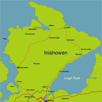
Inishowen
Encyclopedia

Peninsula
A peninsula is a piece of land that is bordered by water on three sides but connected to mainland. In many Germanic and Celtic languages and also in Baltic, Slavic and Hungarian, peninsulas are called "half-islands"....
in County Donegal
County Donegal
County Donegal is a county in Ireland. It is part of the Border Region and is also located in the province of Ulster. It is named after the town of Donegal. Donegal County Council is the local authority for the county...
, part of the Province
Provinces of Ireland
Ireland has historically been divided into four provinces: Leinster, Ulster, Munster and Connacht. The Irish word for this territorial division, cúige, literally meaning "fifth part", indicates that there were once five; the fifth province, Meath, was incorporated into Leinster, with parts going to...
of Ulster
Ulster
Ulster is one of the four provinces of Ireland, located in the north of the island. In ancient Ireland, it was one of the fifths ruled by a "king of over-kings" . Following the Norman invasion of Ireland, the ancient kingdoms were shired into a number of counties for administrative and judicial...
in the north of Ireland
Ireland
Ireland is an island to the northwest of continental Europe. It is the third-largest island in Europe and the twentieth-largest island on Earth...
. It is also the largest peninsula in all of Ireland
Ireland
Ireland is an island to the northwest of continental Europe. It is the third-largest island in Europe and the twentieth-largest island on Earth...
. Inishowen is a picturesque location with a rich history. The peninsula includes Irelands' most northerly point, Malin Head
Malin Head
Malin Head , on the Inishowen Peninsula, County Donegal, is usually given as the most northerly headland of the mainland of Ireland . In fact, the most northerly point is actually a headland named Banba's Crown on the Inishowen Peninsula about 2 km to the northeast...
, along with Lagg sand dunes, some of the highest in Europe
Europe
Europe is, by convention, one of the world's seven continents. Comprising the westernmost peninsula of Eurasia, Europe is generally 'divided' from Asia to its east by the watershed divides of the Ural and Caucasus Mountains, the Ural River, the Caspian and Black Seas, and the waterways connecting...
, as well as Grianán an Aileach
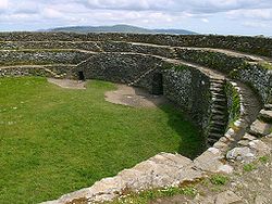
Grianan of Aileach
The Grianán of Aileach is a group of historic monuments in County Donegal, Ireland built on the hill of Grianán which is 244 metres high. Most writers have identified the site as being the great “royal fort” of Aileach...
, a royal fort constructed by the Clan Uí Néill in the sixth century. The Grianán stands at the entrance to the peninsula.
Towns of Inishowen
The main towns and villages of Inishowen are:- BallyliffinBallyliffinBallyliffin is a small village located in the North Western tip of Inishowen, County Donegal, Ireland.The surrounding landscapes are picturesque, with the village being surrounded by Pollan Strand, Binion hill and Crockaughrim hill.-History:...
, Buncrana, BridgendBridgend, County DonegalBridgend or Bridge End is a small village in County Donegal, in the northwest of Ireland, located on the Inishowen peninsula.. It is located on the road to Letterkenny, on the western outskirts of Derry and at the border between Ireland and Northern Ireland. It has a population of 334...
, BurnfootBurnfoot, DonegalBurnfoot is a small village on the Inishowen peninsula in County Donegal, Ireland. It lies within the townland of Ballyederowen. It has a few local shops and a pub. It has a population of 398 ....
, BurtBurt, County DonegalBurt is a parish in County Donegal, Ireland, situated on the main road between Letterkenny and Derry, Northern Ireland.-Location:Located at the base of the Inishowen Peninsula, Burt is a parish and is part the Parish of Fahan.... - CarndonaghCarndonaghCarndonagh is a town on the Inishowen peninsula in County Donegal, Ireland and is home to the Irish Space Exploration Mission. The town is located near Malin Head, the most northerly point of Ireland and lies close to the shores of Trawbeaga Bay...
, Carrowmenagh, ClonmanyClonmanyClonmany is a village in north-west Inishowen, in County Donegal, Ireland. The area has many local beauty spots, and the Ballyliffin area is famous for its golf course. The Urris area to the west of Clonmany village was the last bastion of the Irish language in Inishowen...
, CuldaffCuldaffCuldaff is a village on the Inishowen peninsula of County Donegal, Ireland. Popular for its beach and housing, it attracts people from all over Ireland. It has a population of approximately 200 people.... - Dunaff
- FahanFahanFahan is a district of Inishowen, in County Donegal, located five kilometres south of Buncrana. In Irish, Fahan is named after its patron saint, St...
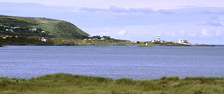
- Glengad, Gleneely, GreencastleGreencastle, County DonegalGreencastle, County Donegal , is a commercial fishing port located in the north of the scenic Inishowen Peninsula on the north coast of County Donegal, part of the Province of Ulster, in the northwest of Ireland. Nowadays, given the decline in the fishing industry, it resembles more closely a...
- Killea
- MalinMalin, County DonegalMalin is a village in County Donegal, Ireland, situated 6km north of Carndonagh. A further 13km north further is Malin Head, the most northerly point of the island of Ireland....
, Malin HeadMalin HeadMalin Head , on the Inishowen Peninsula, County Donegal, is usually given as the most northerly headland of the mainland of Ireland . In fact, the most northerly point is actually a headland named Banba's Crown on the Inishowen Peninsula about 2 km to the northeast...
, MovilleMovilleMoville is a town and coastal resort on the Inishowen Peninsula of County Donegal, close to the northern tip of Ireland.-Location:...
, Muff - NewtowncunninghamNewtowncunninghamNewtown Cunningham , sometimes spelled Newtowncunningham or abbreviated to Newton , is a village in The Laggan district in the east of County Donegal, Ireland. Located on the N13 road 18 km east of Letterkenny and 16 km west of Derry, it is ideally located as a commuter village for both...
- Redcastle
- Quigley's PointQuigley's PointQuigley's Point is a village in County Donegal, Ireland, located on the eastern shores of Inishowen and overlooks the wide expanse of Lough Foyle. To the south is the city of Derry and to the north lie the villages of Moville and Greencastle...
Geography
Inishowen is a peninsula of 884.33 square kilometres (218,523 acres), situated in the northernmost part of Ireland. It is bordered to the north by the Atlantic OceanAtlantic Ocean
The Atlantic Ocean is the second-largest of the world's oceanic divisions. With a total area of about , it covers approximately 20% of the Earth's surface and about 26% of its water surface area...
, to the east by Lough Foyle
Lough Foyle
Lough Foyle, sometimes Loch Foyle , is the estuary of the River Foyle in Ulster. It starts where the Foyle leaves Derry. It separates the Inishowen Peninsula in County Donegal, Republic of Ireland from County Londonderry in Northern Ireland.-Transport:...
, and to the west by Lough Swilly
Lough Swilly
Lough Swilly in Ireland is a glacial fjord or sea inlet lying between the western side of the Inishowen Peninsula and the Fanad Peninsula, in County Donegal. Along with Carlingford Lough and Killary Harbour it is one of three known glacial fjords in Ireland....
. It is joined at the south to the rest of County Donegal
County Donegal
County Donegal is a county in Ireland. It is part of the Border Region and is also located in the province of Ulster. It is named after the town of Donegal. Donegal County Council is the local authority for the county...
, the part known as Tír Conaill, and by County Londonderry
County Londonderry
The place name Derry is an anglicisation of the old Irish Daire meaning oak-grove or oak-wood. As with the city, its name is subject to the Derry/Londonderry name dispute, with the form Derry preferred by nationalists and Londonderry preferred by unionists...
. Historically, the area of County Londonderry west of the River Foyle
River Foyle
The River Foyle is a river in west Ulster in the northwest of Ireland, which flows from the confluence of the rivers Finn and Mourne at the towns of Lifford in County Donegal, Republic of Ireland, and Strabane in County Tyrone, Northern Ireland. From here it flows to the City of Derry, where it...
also forms part of Inishowen, the Foyle forming a natural border. Most of Inishowen's population inhabit the peripheral coastal areas, while the interior consists of low mountains, mostly covered in bogland, the highest of which is "Sliabh Sneacht
Slieve Snaght
Slieve Snaght is a mountain in Inishowen, County Donegal, Ireland, not to be confused with the mountain of the same name in the nearby Derryveagh range.- References :* *...
" (from the Irish, meaning Snow Mountain) which is 619 metres (2,030 feet) above sea level.
Other major hills are located in the Malin Head
Malin Head
Malin Head , on the Inishowen Peninsula, County Donegal, is usually given as the most northerly headland of the mainland of Ireland . In fact, the most northerly point is actually a headland named Banba's Crown on the Inishowen Peninsula about 2 km to the northeast...
peninsula, as well as the Urris Hills in west Inishowen. Due to its geography, Inishowen usually has relatively more moderate weather conditions, with temperatures slightly lower than other parts of Ireland in summer, and slightly warmer in winter, especially during periods of extended cold weather.
Magilligan
Magilligan peninsula lies in the northwest of County Londonderry, Northern Ireland, at the entrance to Lough Foyle...
in County Londonderry
County Londonderry
The place name Derry is an anglicisation of the old Irish Daire meaning oak-grove or oak-wood. As with the city, its name is subject to the Derry/Londonderry name dispute, with the form Derry preferred by nationalists and Londonderry preferred by unionists...
, while another crosses the Swilly, connecting Buncrana with Rathmullan
Rathmullan
Rathmullan is a small seaside village on the Fanad Peninsula in County Donegal, part of the Province of Ulster in Ireland. It is situated on the western shore of Lough Swilly, 11 km north-east of Ramelton and 12 km east of Milford...
. The village of Fahan has a privately built marina.
There are several small outlying islands off the Inishowen coast, most notably Inishtrahull and Glashedy
Glashedy
Glashedy Island is a rock island approximately from Pollan Bay in Ballyliffin, and about south of Malin Head, Donegal, Ireland. Its former name up until the early 19th century was Seale Island....
islands, both uninhabited, although the former was inhabited until the early twentieth century. Inch, located in Lough Swilly
Lough Swilly
Lough Swilly in Ireland is a glacial fjord or sea inlet lying between the western side of the Inishowen Peninsula and the Fanad Peninsula, in County Donegal. Along with Carlingford Lough and Killary Harbour it is one of three known glacial fjords in Ireland....
, is technically no longer an island, as it has a causeway connecting it to the mainland at Tooban
Tooban
Tooban is a location in County Donegal in the north of Ireland....
, south of Fahan.
Lough Swilly is a fjord-like lough, and was of strategic importance for many years to the British Empire as a deep-water harbour. It is also famous as the departure point of the Flight of the Earls
Flight of the Earls
The Flight of the Earls took place on 14 September 1607, when Hugh Ó Neill of Tír Eóghain, Rory Ó Donnell of Tír Chonaill and about ninety followers left Ireland for mainland Europe.-Background to the exile:...
. Lough Foyle is important as the entrance to the river Foyle, and the city of Derry, but is much more shallow than Lough Swilly, and requires the use of a guide boat to guide ships to and from the port of Derry.
A large area of land, most of which now forms part of Grianán Farm, one of the largest farms in Ireland, was reclaimed from a shallow area of Lough Swilly, stretching from the village of Burnfoot to Bridgend and Burt. The outline of this land is plainly visible due to its flatness proving a marked contrast to the more mountainous area surrounding it.
History
Niall of the Nine Hostages
Niall Noígíallach , or in English, Niall of the Nine Hostages, son of Eochaid Mugmedón, was an Irish king, the eponymous ancestor of the Uí Néill kindred who dominated Ireland from the 6th century to the 10th century...
(Niall Naoigeallach, a High King of Ireland
High King of Ireland
The High Kings of Ireland were sometimes historical and sometimes legendary figures who had, or who are claimed to have had, lordship over the whole of Ireland. Medieval and early modern Irish literature portrays an almost unbroken sequence of High Kings, ruling from Tara over a hierarchy of...
), whose name was also used for Tyrone
Tyrone
The name Tyrone can refer to:*County Tyrone, a county in Northern Ireland, roughly corresponding to the ancient kingdom of Tír Eogain*An Earl of Tyrone*A small steam train which runs between Bushmills and the Giant's Causeway in Northern Ireland-Places:...
(Irish: Tír Eoghain). Inis Eoghain is also the ancient homeland of the Mac Lochlainn clan (descended from the tribe of Eoghan), a clan that grew so formidable that they eventually came under siege by a Limerick King, who came north to Aileach, and ordered the destruction of Aileach fort, and that each soldier was to carry away a stone from the fort in order to prevent its rebuilding. Later, after the decline of the Mac Lochlainn clan, the chieftainship of Inis Eoghain was usurped by the Ó Dochartaigh clan
Doherty
The Doherty family is an Irish clan based in County Donegal in the north of the island of Ireland.Like clans in other cultures, Irish clans such as the Dohertys are divided into many septs and regional families...
, as they lost their own homeland in the Laggan valley area of Tír Conaill.
Inishowen has many historical monuments, dating back to early settlements, and including the ruins of several castles, and the fort at Grianán Aileach. The ancient Grianán Ailigh fort at Burt was the one time seat of the High Kings of Ireland, including both High Kings of the Mac Lochlainn Clan, who held power in Inis Eoghain for many centuries. It was restored in the nineteenth century, although some damage in recent years has resulted in the partial collapse of the south side wall. Among the main castle ruins of Inishowen are Carrickabraghey on the Isle of Doagh, the Norman Castle at Greencastle, Inch Castle, Buncrana Castle and Elagh Castle.
In 1196, John de Courcy
John de Courcy
John de Courcy was a Anglo-Norman knight who arrived in Ireland in 1176. From then until his expulsion in 1204, he conquered a considerable territory, endowed religious establishments, built abbeys for both the Benedictines and the Cistercians and built strongholds at Dundrum Castle in County...
, an Anglo-Norman
Anglo-Norman
The Anglo-Normans were mainly the descendants of the Normans who ruled England following the Norman conquest by William the Conqueror in 1066. A small number of Normans were already settled in England prior to the conquest...
knight who had invaded Ulster
Ulster
Ulster is one of the four provinces of Ireland, located in the north of the island. In ancient Ireland, it was one of the fifths ruled by a "king of over-kings" . Following the Norman invasion of Ireland, the ancient kingdoms were shired into a number of counties for administrative and judicial...
in 1177, defeated the King of the Cenél Conaill
Cenél Conaill
The Cenél Conaill is the name of the "kindred" or descendants of Conall Gulban, son of Niall Noígiallach defined by oral and recorded history. They were also known in Scotland as the Kindred of Saint Columba....
and most of Donegal
County Donegal
County Donegal is a county in Ireland. It is part of the Border Region and is also located in the province of Ulster. It is named after the town of Donegal. Donegal County Council is the local authority for the county...
was at his mercy. Two years later he returned to devastate Inishowen.
Ireland's deadliest road accident
July 2010 R238 traffic collision
Eight people were killed on the night of 11 July 2010 when a black Volkswagen Passat collided with a red Toyota Corolla on the R238 Buncrana to Clonmany road on the Inishowen Peninsula in County Donegal, Ireland. It was the deadliest road accident in the country's history. The road at Glasmullen...
happened at Inishowen in July 2010.
Demographics
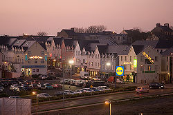
At the last Census of Ireland in 2006, Inishowen counted a population of 31,802, a growth of 8.4% over 1996. Buncrana is the largest town in Inishowen, with a 2006 population of 3,394 in its urban area.Politics
On a national level, Inishowen forms part of the constituency of Donegal North East, which elects three TDs to Dáil ÉireannDáil Éireann
Dáil Éireann is the lower house, but principal chamber, of the Oireachtas , which also includes the President of Ireland and Seanad Éireann . It is directly elected at least once in every five years under the system of proportional representation by means of the single transferable vote...
, the lower house
Lower house
A lower house is one of two chambers of a bicameral legislature, the other chamber being the upper house.Despite its official position "below" the upper house, in many legislatures worldwide the lower house has come to wield more power...
of the Oireachtas
Oireachtas
The Oireachtas , sometimes referred to as Oireachtas Éireann, is the "national parliament" or legislature of Ireland. The Oireachtas consists of:*The President of Ireland*The two Houses of the Oireachtas :**Dáil Éireann...
(the Irish Parliament
Parliament
A parliament is a legislature, especially in those countries whose system of government is based on the Westminster system modeled after that of the United Kingdom. The name is derived from the French , the action of parler : a parlement is a discussion. The term came to mean a meeting at which...
). At the county level, Inishowen is itself an electoral area, electing seven councillors to Donegal County Council. Buncrana town residents also elect representatives to the Buncrana Town Council, one of only three Town Councils in Donegal (the others belonging to Letterkenny and Bundoran).
At the 2009 local elections three members of Fine Gael
Fine Gael
Fine Gael is a centre-right to centrist political party in the Republic of Ireland. It is the single largest party in Ireland in the Oireachtas, in local government, and in terms of Members of the European Parliament. The party has a membership of over 35,000...
were elected, two members from Fianna Fáil
Fianna Fáil
Fianna Fáil – The Republican Party , more commonly known as Fianna Fáil is a centrist political party in the Republic of Ireland, founded on 23 March 1926. Fianna Fáil's name is traditionally translated into English as Soldiers of Destiny, although a more accurate rendition would be Warriors of Fál...
and one each from Sinn Féin
Sinn Féin
Sinn Féin is a left wing, Irish republican political party in Ireland. The name is Irish for "ourselves" or "we ourselves", although it is frequently mistranslated as "ourselves alone". Originating in the Sinn Féin organisation founded in 1905 by Arthur Griffith, it took its current form in 1970...
and the Labour Party
Labour Party (Ireland)
The Labour Party is a social-democratic political party in the Republic of Ireland. The Labour Party was founded in 1912 in Clonmel, County Tipperary, by James Connolly, James Larkin and William X. O'Brien as the political wing of the Irish Trade Union Congress. Unlike the other main Irish...
Media
In addition to the radio stations and newspapers available elsewhere in Donegal, there are several media outlets that are based solely on the peninsula, including two newspapers (the Inish TimesInish Times
The Inish Times is a local Irish newspaper based in Buncrana in Donegal's Inishowen peninsula. It serves the Inishowen area and is also sold in nearby areas such as Derry and Letterkenny...
and the Inishowen Independent
Inishowen Independent
The Inishowen Independent is a local newspaper in County Donegal, Ireland. The paper was launced in March 2007 and is printed on a Tuesday. The paper covers the Inishowen peninsula area in the north of the county and competes against the Inish Times and the Inishowen edition of the Derry Journal...
, both of which are published in Buncrana) and one online daily local news service (InishowenNews.com). Inishowen is also home to the only community station in the county (Inishowen Community Radio
Inishowen Community Radio
Inishowen Community Radio is a local radio station broadcasting on the Inishowen Peninsula in County Donegal in the Republic of Ireland...
, based in Carndonagh). The traditional news source for Inishowen is the Derry Journal
Derry Journal
The Derry Journal is a newspaper based in Derry, Northern Ireland, serving County Londonderry as well as County Donegal in the Republic of Ireland. It is operated by a Johnston Press holding company entitled Derry Journal Newspapers. The paper is published on Tuesday and Friday and is a sister...
, published in nearby Derry
Derry
Derry or Londonderry is the second-biggest city in Northern Ireland and the fourth-biggest city on the island of Ireland. The name Derry is an anglicisation of the Irish name Doire or Doire Cholmcille meaning "oak-wood of Colmcille"...
city, since 1772. It still serves the peninsula as a paper of record.
Tourism
The Inishowen 100 tourist route is an approximately 100-mile signposted scenic drive around the peninsula. It takes in or passes nearby most of the tourist attractions and places of interest on the peninsula.- Inishowen Tourism- Official Inishowen Tourism Website, Accommodation,Sights and Culture, Activites, Events and Entertainment for Inishowen County Donegal.
It starts at Bridgend where there is a lay-by with a large map and information boards. The first leg of the coastal route is along the coast of Lough Swilly
Lough Swilly
Lough Swilly in Ireland is a glacial fjord or sea inlet lying between the western side of the Inishowen Peninsula and the Fanad Peninsula, in County Donegal. Along with Carlingford Lough and Killary Harbour it is one of three known glacial fjords in Ireland....
. It passes Inch Island, Fahan
Fahan
Fahan is a district of Inishowen, in County Donegal, located five kilometres south of Buncrana. In Irish, Fahan is named after its patron saint, St...
(a blue flag beach), Fahan 18-hole Golf Course, Buncrana Town, Tullyarvan Mill (An interpretive centre tracing over 250 years of textile production in the Buncrana area.). It continues along the western coast on Lough Swilly
Lough Swilly
Lough Swilly in Ireland is a glacial fjord or sea inlet lying between the western side of the Inishowen Peninsula and the Fanad Peninsula, in County Donegal. Along with Carlingford Lough and Killary Harbour it is one of three known glacial fjords in Ireland....
.
The routes passes Dunree
Dunree
Dunree is an area in north-west Inishowen, in Co. Donegal, Ireland, and part of the parish of Desertegney.The area has a small local population...
beach, Dunree Fort (military museum) and then turns inland for Mamore Gap (between the Urris
Urris
Urris is an area in the west of the parish of Clonmany, in County Donegal, Ireland. The area hosts the Urris Gaelic Athletic Association team for Gaelic football, which has a pitch located just outside Urris, in the Townland of Straid.-History:...
Hills and Raghtin More mountain), Leenan Bay, Dunaff, Head, Tullagh Bay (a blue flag beach), through the villages of Clonmany
Clonmany
Clonmany is a village in north-west Inishowen, in County Donegal, Ireland. The area has many local beauty spots, and the Ballyliffin area is famous for its golf course. The Urris area to the west of Clonmany village was the last bastion of the Irish language in Inishowen...
and Ballyliffin. Ballyliffin
Ballyliffin
Ballyliffin is a small village located in the North Western tip of Inishowen, County Donegal, Ireland.The surrounding landscapes are picturesque, with the village being surrounded by Pollan Strand, Binion hill and Crockaughrim hill.-History:...
has a well-respected 18-hole golf course.
After Ballyliffin
Ballyliffin
Ballyliffin is a small village located in the North Western tip of Inishowen, County Donegal, Ireland.The surrounding landscapes are picturesque, with the village being surrounded by Pollan Strand, Binion hill and Crockaughrim hill.-History:...
the route passes Dough Island (where there is a famine museum and an interpretive centre). Next is Carndonagh
Carndonagh
Carndonagh is a town on the Inishowen peninsula in County Donegal, Ireland and is home to the Irish Space Exploration Mission. The town is located near Malin Head, the most northerly point of Ireland and lies close to the shores of Trawbeaga Bay...
- the second largest town in Inishowen, after which the route turns North again through Malin Town
Malin, County Donegal
Malin is a village in County Donegal, Ireland, situated 6km north of Carndonagh. A further 13km north further is Malin Head, the most northerly point of the island of Ireland....
(famous for having won its category in Ireland's Tidy Towns competition several times), past Five Finger Strand and then up onto cliff top viewpoint and car park at Knockamany Bens, then down again to sea level with the route looking out into the open Atlantic, before heading for Banba's Crown a peninsula off the peninsula, that is home to Irelands more Northerly point Malin Head
Malin Head
Malin Head , on the Inishowen Peninsula, County Donegal, is usually given as the most northerly headland of the mainland of Ireland . In fact, the most northerly point is actually a headland named Banba's Crown on the Inishowen Peninsula about 2 km to the northeast...
.
On the North Eastern coast passes through Culdaff
Culdaff
Culdaff is a village on the Inishowen peninsula of County Donegal, Ireland. Popular for its beach and housing, it attracts people from all over Ireland. It has a population of approximately 200 people....
village and Culdaff Bay (another Blue Flag beach), the remote Tramone Bay, Kinnagoe Bay
Kinnagoe Bay
Kinnagoe Bay is a secluded beach in Inishowen, County Donegal, Ireland. It is known for being the location of the wreck of the Spanish Armada ship "Trinidad Valencera" in 1588; in memory of which a plaque is mounted. The beach is accessible by a weaving road from the top of the hill.It is one of...
. As the coastline turns towards the East it reaches Lough Foyle
Lough Foyle
Lough Foyle, sometimes Loch Foyle , is the estuary of the River Foyle in Ulster. It starts where the Foyle leaves Derry. It separates the Inishowen Peninsula in County Donegal, Republic of Ireland from County Londonderry in Northern Ireland.-Transport:...
and Shroove on the mouth of the Lough and then Greencastle
Greencastle
Greencastle may refer to:In the United States:* Greencastle, Indiana, a city* Greencastle, Missouri, a city* Greencastle, Pennsylvania, a borough* Greencastle, West Virginia, an unincorporated community...
(a port used by fishing boats and landing point for the car ferry to and from Magilligan
Magilligan
Magilligan peninsula lies in the northwest of County Londonderry, Northern Ireland, at the entrance to Lough Foyle...
in County Londonderry, Northern Ireland
Northern Ireland
Northern Ireland is one of the four countries of the United Kingdom. Situated in the north-east of the island of Ireland, it shares a border with the Republic of Ireland to the south and west...
). Then as the road heads South along along Lough Foyle it passes through Moville
Moville
Moville is a town and coastal resort on the Inishowen Peninsula of County Donegal, close to the northern tip of Ireland.-Location:...
town, Quigley's Point
Quigley's Point
Quigley's Point is a village in County Donegal, Ireland, located on the eastern shores of Inishowen and overlooks the wide expanse of Lough Foyle. To the south is the city of Derry and to the north lie the villages of Moville and Greencastle...
and the Village of Muff
Muff, County Donegal
Muff is a village in County Donegal, Ireland. It is near the mouth of the River Foyle and sits at the border between the Republic of Ireland and Northern Ireland. The village of Culmore and the city of Derry are to the south...
where the road turns right and heads back to Bridgend where the journey started.
Festivals
• DylanFest on the Lough, Ireland's only annual festival of Bob DylanBob Dylan
Bob Dylan is an American singer-songwriter, musician, poet, film director and painter. He has been a major and profoundly influential figure in popular music and culture for five decades. Much of his most celebrated work dates from the 1960s when he was an informal chronicler and a seemingly...
music, takes place in Moville
Moville
Moville is a town and coastal resort on the Inishowen Peninsula of County Donegal, close to the northern tip of Ireland.-Location:...
where bands from all over Europe and visitors from all over the world congregate to play and hear Bob Dylan music. The DylanFest takes place in the pubs, the streets of the town, on the shores of Lough Foyle and in the picturesque grounds of the hostel at Gulladuff House.
• BeatlesFest on the Lough takes place every year when bands from all over Europe come and play in the streets and pubs of Moville.
• The Buncrana Music and Arts Festival. Aimed at being a 'Free Festival', organisers only ask for a donation for entrance.
Further reading
- Morton, O. 2003. "The macroalgae of County Donegal, Ireland". Bull. Ir. Biogeog. Soc.; No. 27: 3-164.
- Seán Beattie, Ancient Monuments of Inishowen, North Donegal. Lighthouse Publications, Carndonagh, Inishowen, County Donegal, 1994 & 2009.
External links
- Inishowen Tourism- Inishowen Official tourism website for accommodation
- Inishowen News- Inishowen News online with community notes, local sport and the Business Directory
- Inish Times - Buncrana-based local newspaper, covering Inishowen news
- Raidio Pobail Inis Eoghain - Inishowen Community Radio (ICR)
- Traditional housing of Inishowen