

Ottawa-Bonnechere Graben
Encyclopedia
Graben
In geology, a graben is a depressed block of land bordered by parallel faults. Graben is German for ditch. Graben is used for both the singular and plural....
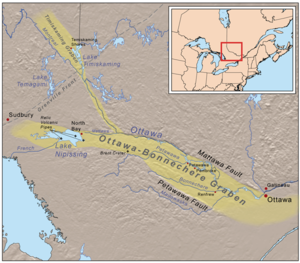
(also known as the Ottawa Graben), with its branch the Timiskaming Graben, is an ancient rift valley
Rift valley
A rift valley is a linear-shaped lowland between highlands or mountain ranges created by the action of a geologic rift or fault. This action is manifest as crustal extension, a spreading apart of the surface which is subsequently further deepened by the forces of erosion...
in the Canadian Shield
Canadian Shield
The Canadian Shield, also called the Laurentian Plateau, or Bouclier Canadien , is a vast geological shield covered by a thin layer of soil that forms the nucleus of the North American or Laurentia craton. It is an area mostly composed of igneous rock which relates to its long volcanic history...
of Northeastern Ontario
Northeastern Ontario
Northeastern Ontario is the region within the Canadian province of Ontario which lies north and east of Lakes Superior and Huron.Northeastern Ontario consists of the districts of Algoma, Sudbury, Cochrane, Timiskaming, Nipissing and Manitoulin; and the single-tier municipality of Greater...
and Quebec
Quebec
Quebec or is a province in east-central Canada. It is the only Canadian province with a predominantly French-speaking population and the only one whose sole official language is French at the provincial level....
, Canada
Canada
Canada is a North American country consisting of ten provinces and three territories. Located in the northern part of the continent, it extends from the Atlantic Ocean in the east to the Pacific Ocean in the west, and northward into the Arctic Ocean...
. This rift valley was formed when the Earth's crust
Crust (geology)
In geology, the crust is the outermost solid shell of a rocky planet or natural satellite, which is chemically distinct from the underlying mantle...
moved downward about a kilometre between two major fault zones known as the Mattawa and Petawawa faults. These ancient faults are still active and occasionally release stress in the form of earthquake
Earthquake
An earthquake is the result of a sudden release of energy in the Earth's crust that creates seismic waves. The seismicity, seismism or seismic activity of an area refers to the frequency, type and size of earthquakes experienced over a period of time...
s, such as the 1935 Timiskaming earthquake
1935 Timiskaming earthquake
The 1935 Timiskaming earthquake was a magnitude 6.2 earthquake that occurred on November 1, 1935 in the Abitibi-Témiscamingue region of Quebec...
and the 2000 Kipawa earthquake
2000 Kipawa earthquake
The 2000 Kipwa earthquake was a 5.2 magnitude earthquake that struck Quebec and Ontario, Canada at 6:22 a.m. on Saturday, January 1, 2000. It occurred in the Western Quebec Seismic Zone....
. The length of the graben is about 700 km (435 mi).
The Ottawa-Bonnechere Graben runs from the Montreal
Montreal
Montreal is a city in Canada. It is the largest city in the province of Quebec, the second-largest city in Canada and the seventh largest in North America...
area on the east to near Sudbury and Lake Nipissing
Lake Nipissing
Lake Nipissing is a lake in the Canadian province of Ontario. It has a surface area of , a mean elevation of above sea level, and is located between the Ottawa River and Georgian Bay. Excluding the Great Lakes, Lake Nipissing is the fifth-largest lake in Ontario. It is relatively shallow for a...
on the west. On the east, it joins the Saint Lawrence rift system
Saint Lawrence rift system
The Saint Lawrence rift system is a seismically active zone paralleling the Saint Lawrence River. The rift system trends northeast and southwest and forms a half-graben that links the Ottawa-Bonnechere and the Saguenay grabens. The rift system extends more than 1000 km along the Saint Lawrence...
, a half-graben which extends more than 1000 km along the Saint Lawrence River
Saint Lawrence River
The Saint Lawrence is a large river flowing approximately from southwest to northeast in the middle latitudes of North America, connecting the Great Lakes with the Atlantic Ocean. It is the primary drainage conveyor of the Great Lakes Basin...
valley
Valley
In geology, a valley or dale is a depression with predominant extent in one direction. A very deep river valley may be called a canyon or gorge.The terms U-shaped and V-shaped are descriptive terms of geography to characterize the form of valleys...
and links the Ottawa and Saguenay Graben
Saguenay Graben
The Saguenay Graben is a rift valley or graben in the geological Grenville Province of southern Quebec, Canada. It is an elongated flat-bottomed basin long and wide, bounded by normal faults running parallel to its length....
.
The 200 km (124 mi) segment of the Ottawa-Bonnechere Graben west of Ottawa was the first to be recognized as a graben. Since then, it has been traced west to Lake Nipissing, and northwestwards from the confluence
Confluence
Confluence, in geography, describes the meeting of two or more bodies of water.Confluence may also refer to:* Confluence , a property of term rewriting systems...
of the Mattawa
Mattawa River
The Mattawa River is a river in central Ontario, Canada. It flows east from Trout Lake east of North Bay and enters the Ottawa River at the town of Mattawa. Counting from the head of Trout Lake, it is 76 km in length...
and Ottawa River
Ottawa River
The Ottawa River is a river in the Canadian provinces of Ontario and Quebec. For most of its length, it now defines the border between these two provinces.-Geography:...
s up the valley of the latter stream to Lake Timiskaming
Lake Timiskaming
Lake Timiskaming is a large freshwater lake on the provincial border between Ontario and Quebec, Canada. The lake, which forms part of the Ottawa River, is in length and covers an area of almost . Its water level ranges between and above sea-level, with a mean annual average of . The lake is...
and the Montreal River
Montreal River (Timiskaming District, Ontario)
The Montreal River is a river in Timiskaming District, Ontario, Canada. It travels from its source at Smoothwater Lake to its mouth at Lake Timiskaming on the Ottawa River. The river is a significant source of hydroelectricity.-Course:...
valley. This latter branch is the Timiskaming Graben. At the rifts' western termini, the main faults split into divergent smaller faults. The graben has been interpreted as a Late Proterozoic to Early Paleozoic
Paleozoic
The Paleozoic era is the earliest of three geologic eras of the Phanerozoic eon, spanning from roughly...
failed arm of the Iapetus Ocean
Iapetus Ocean
The Iapetus Ocean was an ocean that existed in the Neoproterozoic and Paleozoic eras of the geologic timescale . The Iapetus Ocean was situated in the southern hemisphere, between the paleocontinents of Laurentia, Baltica and Avalonia...
, the precursor to the Atlantic Ocean. The main Ottawa-Bonnechere Graben is associated with collapse of the regional carbonate
Carbonate
In chemistry, a carbonate is a salt of carbonic acid, characterized by the presence of the carbonate ion, . The name may also mean an ester of carbonic acid, an organic compound containing the carbonate group C2....
platform and formation of deep water shale basins by ~452 mya (million years ago); similar events formed the Temiskaming Graben ~449-451 mya. These graben were reactivated during the breakup of supercontinent
Supercontinent
In geology, a supercontinent is a landmass comprising more than one continental core, or craton. The assembly of cratons and accreted terranes that form Eurasia qualifies as a supercontinent today.-History:...
Pangaea
Pangaea
Pangaea, Pangæa, or Pangea is hypothesized as a supercontinent that existed during the Paleozoic and Mesozoic eras about 250 million years ago, before the component continents were separated into their current configuration....
some 150 mya.
Geology
Erosion
Erosion is when materials are removed from the surface and changed into something else. It only works by hydraulic actions and transport of solids in the natural environment, and leads to the deposition of these materials elsewhere...
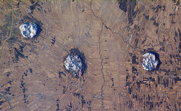
has removed the volcanic peaks, exposing a number of relic volcanic pipe
Volcanic pipe
Volcanic pipes are subterranean geological structures formed by the violent, supersonic eruption of deep-origin volcanoes. They are considered to be a type of diatreme. Volcanic pipes are composed of a deep, narrow cone of solidified magma , and are usually largely composed of one of two...
s, such as Callander Bay
Callander Bay
Callander Bay is a bay at the extreme east of Lake Nipissing in Parry Sound District, Ontario, Canada. It is in diameter and the main community of Callander is located on its east side.-Geology:...
and the Manitou Islands
Manitou Islands (Lake Nipissing)
The Manitou Islands are a series of small islands in Lake Nipissing, in Nipissing District, Ontario, Canada. The islands form a circle and lie southwest of North Bay.-History:...
in Lake Nipissing. These features are subterranean geological
Geology
Geology is the science comprising the study of solid Earth, the rocks of which it is composed, and the processes by which it evolves. Geology gives insight into the history of the Earth, as it provides the primary evidence for plate tectonics, the evolutionary history of life, and past climates...
structures formed by the violent, supersonic
Supersonic
Supersonic speed is a rate of travel of an object that exceeds the speed of sound . For objects traveling in dry air of a temperature of 20 °C this speed is approximately 343 m/s, 1,125 ft/s, 768 mph or 1,235 km/h. Speeds greater than five times the speed of sound are often...
eruption of deep-origin volcano
Volcano
2. Bedrock3. Conduit 4. Base5. Sill6. Dike7. Layers of ash emitted by the volcano8. Flank| 9. Layers of lava emitted by the volcano10. Throat11. Parasitic cone12. Lava flow13. Vent14. Crater15...
es. Batholith
Batholith
A batholith is a large emplacement of igneous intrusive rock that forms from cooled magma deep in the Earth's crust...
s and dikes
Dike (geology)
A dike or dyke in geology is a type of sheet intrusion referring to any geologic body that cuts discordantly across* planar wall rock structures, such as bedding or foliation...
were also exposed by erosion, such as the Timber Lake, Mulock, West Arm, Powassan and Bonfield batholiths. The expressions of a thick pile of dominantly mafic
Mafic
Mafic is an adjective describing a silicate mineral or rock that is rich in magnesium and iron; the term is a portmanteau of the words "magnesium" and "ferric". Most mafic minerals are dark in color and the relative density is greater than 3. Common rock-forming mafic minerals include olivine,...
, bimodel volcanics and the Tibbit Hill volcanics in the Humber Zone of the Quebec
Quebec
Quebec or is a province in east-central Canada. It is the only Canadian province with a predominantly French-speaking population and the only one whose sole official language is French at the provincial level....
Appalachians
Appalachian Mountains
The Appalachian Mountains #Whether the stressed vowel is or ,#Whether the "ch" is pronounced as a fricative or an affricate , and#Whether the final vowel is the monophthong or the diphthong .), often called the Appalachians, are a system of mountains in eastern North America. The Appalachians...
are believed to be related to the formation of the Ottawa-Bonnechere Graben. The precise age of these volcanics is unknown but they are either early Cambrian
Cambrian
The Cambrian is the first geological period of the Paleozoic Era, lasting from Mya ; it is succeeded by the Ordovician. Its subdivisions, and indeed its base, are somewhat in flux. The period was established by Adam Sedgwick, who named it after Cambria, the Latin name for Wales, where Britain's...
and late Precambrian
Precambrian
The Precambrian is the name which describes the large span of time in Earth's history before the current Phanerozoic Eon, and is a Supereon divided into several eons of the geologic time scale...
. This volcanism was probably coeval with the emplacement of the Grenville dike swarm
Grenville dike swarm
The Grenville dike swarm is a large Proterozoic dike swarm in the Canadian provinces of Ontario and Quebec. It is one of the several major magmatic events in the Canadian Shield and it possibly formed 590 million years ago along a triple junction that might have been related to a mantle plume...
.
Minor but significant igneous activity occurred during the Mesozoic era, including kimberlite
Kimberlite
Kimberlite is a type of potassic volcanic rock best known for sometimes containing diamonds. It is named after the town of Kimberley in South Africa, where the discovery of an diamond in 1871 spawned a diamond rush, eventually creating the Big Hole....
emplacement during the Jurassic period, and the development of alkalic
Igneous rock
Igneous rock is one of the three main rock types, the others being sedimentary and metamorphic rock. Igneous rock is formed through the cooling and solidification of magma or lava...
intrusion
Intrusion
An intrusion is liquid rock that forms under Earth's surface. Magma from under the surface is slowly pushed up from deep within the earth into any cracks or spaces it can find, sometimes pushing existing country rock out of the way, a process that can take millions of years. As the rock slowly...
s along the Ottawa-Bonnechere Graben and elsewhere in Ontario. This second episode of alkalic volcanism occurred along the eastern part of the graben in the early Cretaceous
Cretaceous
The Cretaceous , derived from the Latin "creta" , usually abbreviated K for its German translation Kreide , is a geologic period and system from circa to million years ago. In the geologic timescale, the Cretaceous follows the Jurassic period and is followed by the Paleogene period of the...
. The products of this event are the Monteregian Hills in Montérégie
Montérégie
Montérégie is an administrative region in southwest Québec. It includes the cities of Boucherville, Brossard, Granby, Longueuil, Salaberry-de-Valleyfield, Saint-Jean-sur-Richelieu, Saint-Hyacinthe, Sorel-Tracy, and Vaudreuil-Dorion....
, Quebec. These are thought to have formed as a result of the North American Plate
North American Plate
The North American Plate is a tectonic plate covering most of North America, Greenland, Cuba, Bahamas, and parts of Siberia, Japan and Iceland. It extends eastward to the Mid-Atlantic Ridge and westward to the Chersky Range in eastern Siberia. The plate includes both continental and oceanic crust...
sliding westward over a long-lived center of upwelling magma
Magma
Magma is a mixture of molten rock, volatiles and solids that is found beneath the surface of the Earth, and is expected to exist on other terrestrial planets. Besides molten rock, magma may also contain suspended crystals and dissolved gas and sometimes also gas bubbles. Magma often collects in...
called the New England hotspot
New England hotspot
The New England hotspot, also referred to as the Great Meteor hotspot, is a long-lived volcanic hotspot in the Atlantic Ocean. The hotspot's most recent eruptive center is the Great Meteor Seamount, and it probably created a short line of mid to late-Tertiary age seamounts on the African Plate but...
, and is the eroded
Erosion
Erosion is when materials are removed from the surface and changed into something else. It only works by hydraulic actions and transport of solids in the natural environment, and leads to the deposition of these materials elsewhere...
remnants of intrusive stocks. These intrusive stocks have been variously interpreted as the feeder intrusions of long extinct volcanoes, which would have been active about 125 million years ago, or as intrusives that never breached the surface in volcanic activity. Of all these features, Mont Saint-Hilaire
Mont Saint-Hilaire
Mont Saint-Hilaire , is an isolated hill, high, in the Montérégie region of southern Quebec. It is about thirty kilometres east of Montreal, and immediately east of the Richelieu River. It is one of the Monteregian Hills...
is the best known as a source of rare specimens.
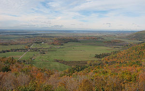
Escarpment
An escarpment is a steep slope or long cliff that occurs from erosion or faulting and separates two relatively level areas of differing elevations.-Description and variants:...
that forms the southern edge of the Gatineau Hills
Gatineau Hills
The Gatineau Hills are a geological formation in Canada that makes up part of the southern tip of the Canadian Shield, and acts as the northern shoulder of the Ottawa Valley...
. This escarpment, called the Eardley Escarpment, makes this part of the graben an attractive location for rock climber
Rock climbing
Rock climbing also lightly called 'The Gravity Game', is a sport in which participants climb up, down or across natural rock formations or artificial rock walls. The goal is to reach the summit of a formation or the endpoint of a pre-defined route without falling...
s and hiker
Hiking
Hiking is an outdoor activity which consists of walking in natural environments, often in mountainous or other scenic terrain. People often hike on hiking trails. It is such a popular activity that there are numerous hiking organizations worldwide. The health benefits of different types of hiking...
s, offering a beautiful view of the relatively flat fields below, which extend to the Ottawa River.
On or near a branch of the Ottawa-Bonnechere Graben lies the Brent impact crater
Brent crater
The Brent crater is an impact crater in both the geographic township of Deacon, Unorganized South Nipissing District and the municipal township of Papineau-Cameron in Nipissing District, northeastern Ontario, Canada, located north of Cedar Lake in northern Algonquin Provincial Park. It is in...
. It is 3.8 km (2 mi) in diameter
Diameter
In geometry, a diameter of a circle is any straight line segment that passes through the center of the circle and whose endpoints are on the circle. The diameters are the longest chords of the circle...
and the age is estimated about 400 million years (Early Devonian
Devonian
The Devonian is a geologic period and system of the Paleozoic Era spanning from the end of the Silurian Period, about 416.0 ± 2.8 Mya , to the beginning of the Carboniferous Period, about 359.2 ± 2.5 Mya...
). The impact crater
Impact crater
In the broadest sense, the term impact crater can be applied to any depression, natural or manmade, resulting from the high velocity impact of a projectile with a larger body...
, which was first recognized in 1951 from aerial photographs, formed in Precambrian
Precambrian
The Precambrian is the name which describes the large span of time in Earth's history before the current Phanerozoic Eon, and is a Supereon divided into several eons of the geologic time scale...
gneiss
Gneiss
Gneiss is a common and widely distributed type of rock formed by high-grade regional metamorphic processes from pre-existing formations that were originally either igneous or sedimentary rocks.-Etymology:...
es.
Geophysical and diamond drilling investigations show that the crater has a present depth of about 425 m (1,394 ft) but is partly filled with sedimentary rock
Sedimentary rock
Sedimentary rock are types of rock that are formed by the deposition of material at the Earth's surface and within bodies of water. Sedimentation is the collective name for processes that cause mineral and/or organic particles to settle and accumulate or minerals to precipitate from a solution....
s with a thickness of about 274 m (899 ft). The rocks beneath the crater floor are thoroughly fragmented over a depth of about 610 m (2,001 ft). Like the similar Pingualuit crater, the Brent crater is attributed to the high speed impact of a giant meteorite
Meteorite
A meteorite is a natural object originating in outer space that survives impact with the Earth's surface. Meteorites can be big or small. Most meteorites derive from small astronomical objects called meteoroids, but they are also sometimes produced by impacts of asteroids...
. It is calculated that the impact released energy equaling 250 megatons
TNT equivalent
TNT equivalent is a method of quantifying the energy released in explosions. The ton of TNT is a unit of energy equal to 4.184 gigajoules, which is approximately the amount of energy released in the detonation of one ton of TNT...
of TNT and occurred when this area was probably covered by a shallow sea
Sea
A sea generally refers to a large body of salt water, but the term is used in other contexts as well. Most commonly, it means a large expanse of saline water connected with an ocean, and is commonly used as a synonym for ocean...
.
History
The depressions formed by the graben across the rugged Canadian Shield were a spillwaySpillway
A spillway is a structure used to provide the controlled release of flows from a dam or levee into a downstream area, typically being the river that was dammed. In the UK they may be known as overflow channels. Spillways release floods so that the water does not overtop and damage or even destroy...
for the Great Lakes
Great Lakes
The Great Lakes are a collection of freshwater lakes located in northeastern North America, on the Canada – United States border. Consisting of Lakes Superior, Michigan, Huron, Erie, and Ontario, they form the largest group of freshwater lakes on Earth by total surface, coming in second by volume...
after the last Ice Age
Ice age
An ice age or, more precisely, glacial age, is a generic geological period of long-term reduction in the temperature of the Earth's surface and atmosphere, resulting in the presence or expansion of continental ice sheets, polar ice sheets and alpine glaciers...
. Later they became a thoroughfare for exploration and trade. These depressions now contain the Ottawa River and its tributary the Mattawa, which rises at Trout Lake
Trout Lake (Ontario)
Trout Lake is a lake in municipalities of East Ferris and North Bay, Nipissing District in Northeastern Ontario, Canada, approximately east of the much larger Lake Nipissing. Trout Lake is the source of the Mattawa River and a significant body of water on a well-known historic North American...
near Lake Nipissing. The latter is the source of the French River
French River
French River may refer to:*Any river within the country of France -Rivers named "French":*In Canada:**French River, Colchester, Nova Scotia**French River, Pictou, Nova Scotia**French River *In the United States:...
, which drains into Lake Huron
Lake Huron
Lake Huron is one of the five Great Lakes of North America. Hydrologically, it comprises the larger portion of Lake Michigan-Huron. It is bounded on the east by the Canadian province of Ontario and on the west by the state of Michigan in the United States...
. This water route, with few portage
Portage
Portage or portaging refers to the practice of carrying watercraft or cargo over land to avoid river obstacles, or between two bodies of water. A place where this carrying occurs is also called a portage; a person doing the carrying is called a porter.The English word portage is derived from the...
s, connected Lake Huron and the Saint Lawrence River by a much shorter route than through the lower Great Lakes. It was the mainline of the French-Canadian voyageurs
Voyageurs
The Voyageurs were the persons who engaged in the transportation of furs by canoe during the fur trade era. Voyageur is a French word which literally translates to "traveler"...
engaged in the fur trade
Fur trade
The fur trade is a worldwide industry dealing in the acquisition and sale of animal fur. Since the establishment of world market for in the early modern period furs of boreal, polar and cold temperate mammalian animals have been the most valued...
; they took canoes on the waterways along this route from Montreal
Montreal
Montreal is a city in Canada. It is the largest city in the province of Quebec, the second-largest city in Canada and the seventh largest in North America...
to the upper Great Lakes and the pays d'en haut—the "upper country" in the old Northwest.
The valley of the Ottawa and Montreal Rivers and Lake Timiskaming was also part of a branch route to James Bay
James Bay
James Bay is a large body of water on the southern end of Hudson Bay in Canada. Both bodies of water extend from the Arctic Ocean. James Bay borders the provinces of Quebec and Ontario; islands within the bay are part of Nunavut...
in the days of the fur brigades. The valleys are now used by more modern forms of transportation, including the Canadian Pacific Railway
Canadian Pacific Railway
The Canadian Pacific Railway , formerly also known as CP Rail between 1968 and 1996, is a historic Canadian Class I railway founded in 1881 and now operated by Canadian Pacific Railway Limited, which began operations as legal owner in a corporate restructuring in 2001...
and the Trans-Canada Highway
Trans-Canada Highway
The Trans-Canada Highway is a federal-provincial highway system that joins the ten provinces of Canada. It is, along with the Trans-Siberian Highway and Australia's Highway 1, one of the world's longest national highways, with the main route spanning 8,030 km...
.
After the arrival of European settlers in North America, the Mattawa River
Mattawa River
The Mattawa River is a river in central Ontario, Canada. It flows east from Trout Lake east of North Bay and enters the Ottawa River at the town of Mattawa. Counting from the head of Trout Lake, it is 76 km in length...
was an important transportation corridor for native peoples of the region and formed part of the water route leading west to Lake Superior
Lake Superior
Lake Superior is the largest of the five traditionally-demarcated Great Lakes of North America. It is bounded to the north by the Canadian province of Ontario and the U.S. state of Minnesota, and to the south by the U.S. states of Wisconsin and Michigan. It is the largest freshwater lake in the...
in the days of the fur trade
Fur trade
The fur trade is a worldwide industry dealing in the acquisition and sale of animal fur. Since the establishment of world market for in the early modern period furs of boreal, polar and cold temperate mammalian animals have been the most valued...
. Canoe
Canoe
A canoe or Canadian canoe is a small narrow boat, typically human-powered, though it may also be powered by sails or small electric or gas motors. Canoes are usually pointed at both bow and stern and are normally open on top, but can be decked over A canoe (North American English) or Canadian...
s travelling north up the Ottawa turned left to enter the Mattawa, reaching Lake Nipissing
Lake Nipissing
Lake Nipissing is a lake in the Canadian province of Ontario. It has a surface area of , a mean elevation of above sea level, and is located between the Ottawa River and Georgian Bay. Excluding the Great Lakes, Lake Nipissing is the fifth-largest lake in Ontario. It is relatively shallow for a...
by way of "La Vase Portage", an 11 km (7 mi) stretch of water and portage
Portage
Portage or portaging refers to the practice of carrying watercraft or cargo over land to avoid river obstacles, or between two bodies of water. A place where this carrying occurs is also called a portage; a person doing the carrying is called a porter.The English word portage is derived from the...
s. In the 19th century, the river provided access to large untouched stands of white pine. The river was also used to transport logs to sawmills. While logging
Logging
Logging is the cutting, skidding, on-site processing, and loading of trees or logs onto trucks.In forestry, the term logging is sometimes used in a narrow sense concerning the logistics of moving wood from the stump to somewhere outside the forest, usually a sawmill or a lumber yard...
is still an important industry in this region, almost the full length of the river has been designated as a Canadian Heritage River, and as such, its shores are now protected from further development and logging. Today, the river and lakes are mainly used for recreation.
See also
- Midcontinent Rift SystemMidcontinent Rift SystemThe Midcontinent Rift System or Keweenawan Rift is a long geological rift in the center of the North American continent and south-central part of the North American plate. It formed when the continent's core, the North American craton, began to split apart during the Mesoproterozoic era of the...
- Ottawa ValleyOttawa ValleyThe Ottawa Valley is the valley along the boundary between Eastern Ontario and Western Quebec along the Ottawa River. The valley is the transition between the Saint Lawrence Lowlands and the Canadian Shield...
- Volcanism of Canada
- Volcanism of Eastern CanadaVolcanism of Eastern CanadaVolcanism of Eastern Canada has led to the formation of hundreds of volcanic areas and extensive lava formations, indicating volcanism played a major role in shaping its surface. The region's different volcano and lava types originate from different tectonic settings and types of volcanic...
External links
- Welcome to the Ottawa Valley, a Canadian Geographic article about the valley
- Ottawa River article at Great Canadian Rivers
- http://www.canadiangeographic.ca/Magazine/SO05/feature.asp The preview of the Canadian Geographic article, G'Day G'Day and Welcome to the Valley