
1935 Timiskaming earthquake
Encyclopedia
The 1935 Timiskaming earthquake was a magnitude
6.2 earthquake
that occurred on November 1, 1935 in the Abitibi-Témiscamingue
region of Quebec
. It is one of the major earthquakes that have occurred in the Western Quebec Seismic Zone
.
The earthquake had its epicenter
on a thrust fault
in the Ottawa-Bonnechere Graben
, approximately 10 kilometres north east of Témiscaming
, and occurred at 1:03 a.m. ET.
Although the most significant damage connected to the earthquake was to chimney
s, both in the immediate area and as far south as North Bay
and Mattawa
, a railroad embankment near Parent
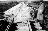
, 300 km away, also collapsed as a result of the earthquake. Researcher E. A. Hodgson later concluded that the embankment slide was already imminent, and was merely hastened by the earthquake vibrations. Some rockfalls and structural cracks were also reported, although there were few major structural collapses aside from the Parent embankment. The relative lack of major damage, despite the fact that it was a strong earthquake, has been attributed primarily to the sparseness of the area's population.
The earthquake was felt over a wide swath of North America, extending west to Fort William
(now Thunder Bay), east to Fredericton, New Brunswick, north to James Bay
and south as far as Kentucky
and West Virginia
. Occasional aftershocks were also reported for several months following the earthquake.
A magnitude 5.2 earthquake on January 1, 2000 had its epicentre at Lake Kipawa, very near the epicentre of the 1935 quake. See 2000 Kipawa earthquake
.
Richter magnitude scale
The expression Richter magnitude scale refers to a number of ways to assign a single number to quantify the energy contained in an earthquake....
6.2 earthquake
Earthquake
An earthquake is the result of a sudden release of energy in the Earth's crust that creates seismic waves. The seismicity, seismism or seismic activity of an area refers to the frequency, type and size of earthquakes experienced over a period of time...
that occurred on November 1, 1935 in the Abitibi-Témiscamingue
Abitibi-Témiscamingue
Abitibi-Témiscamingue is a region located in western Quebec, Canada, along the border with Ontario. It became part of the province in 1898. It has a land area of 57,674.26 km2 . As of the 2006 census, the population of the region was 143,872 inhabitants.-History:The land was first occupied...
region of Quebec
Quebec
Quebec or is a province in east-central Canada. It is the only Canadian province with a predominantly French-speaking population and the only one whose sole official language is French at the provincial level....
. It is one of the major earthquakes that have occurred in the Western Quebec Seismic Zone
Western Quebec Seismic Zone
The Western Quebec Seismic Zone is a large seismically active area that surrounds the Ottawa Valley from Montreal to Témiscaming, as well as the Laurentian Mountains and Eastern Ontario. It is monitored by a local seismographic network which is synced to the Canadian National Seismic network. It...
.
The earthquake had its epicenter
Epicenter
The epicenter or epicentre is the point on the Earth's surface that is directly above the hypocenter or focus, the point where an earthquake or underground explosion originates...
on a thrust fault
Thrust fault
A thrust fault is a type of fault, or break in the Earth's crust across which there has been relative movement, in which rocks of lower stratigraphic position are pushed up and over higher strata. They are often recognized because they place older rocks above younger...
in the Ottawa-Bonnechere Graben
Ottawa-Bonnechere Graben
The Ottawa-Bonnechere Graben , with its branch the Timiskaming Graben, is an ancient rift valley in the Canadian Shield of Northeastern Ontario and Quebec, Canada. This rift valley was formed when the Earth's crust moved downward about a kilometre between two major fault zones known as the Mattawa...
, approximately 10 kilometres north east of Témiscaming
Témiscaming, Quebec
Témiscaming is a town located at the south end of Lac Témiscamingue on the upper Ottawa River in the Témiscamingue Regional County Municipality of western Quebec, Canada. Also nearby is Lake Kipawa.-History:...
, and occurred at 1:03 a.m. ET.
Although the most significant damage connected to the earthquake was to chimney
Chimney
A chimney is a structure for venting hot flue gases or smoke from a boiler, stove, furnace or fireplace to the outside atmosphere. Chimneys are typically vertical, or as near as possible to vertical, to ensure that the gases flow smoothly, drawing air into the combustion in what is known as the...
s, both in the immediate area and as far south as North Bay
North Bay, Ontario
North Bay is a city in Northeastern Ontario, Canada. It is the seat of Nipissing District, and takes its name from its position on the shore of Lake Nipissing.-History:...
and Mattawa
Mattawa, Ontario
Mattawa is a town in northeastern Ontario, Canada, at the confluence of the Mattawa and Ottawa Rivers in Nipissing District. Mattawa means "Meeting of the Waters" in Ojibwa...
, a railroad embankment near Parent
Parent, Quebec
Parent is a community in northern Quebec, Canada, located within the City of La Tuque and about north-west of La Tuque's town centre. In 2006, it had a population of 251, and in 2001, it had 295....
, 300 km away, also collapsed as a result of the earthquake. Researcher E. A. Hodgson later concluded that the embankment slide was already imminent, and was merely hastened by the earthquake vibrations. Some rockfalls and structural cracks were also reported, although there were few major structural collapses aside from the Parent embankment. The relative lack of major damage, despite the fact that it was a strong earthquake, has been attributed primarily to the sparseness of the area's population.
The earthquake was felt over a wide swath of North America, extending west to Fort William
Fort William, Ontario
Fort William was a city in Northern Ontario, located on the Kaministiquia River, at its entrance to Lake Superior. It amalgamated with Port Arthur and the townships of Neebing and McIntyre to form the city of Thunder Bay in January 1970. Ever since then it has been the largest city in Northwestern...
(now Thunder Bay), east to Fredericton, New Brunswick, north to James Bay
James Bay
James Bay is a large body of water on the southern end of Hudson Bay in Canada. Both bodies of water extend from the Arctic Ocean. James Bay borders the provinces of Quebec and Ontario; islands within the bay are part of Nunavut...
and south as far as Kentucky
Kentucky
The Commonwealth of Kentucky is a state located in the East Central United States of America. As classified by the United States Census Bureau, Kentucky is a Southern state, more specifically in the East South Central region. Kentucky is one of four U.S. states constituted as a commonwealth...
and West Virginia
West Virginia
West Virginia is a state in the Appalachian and Southeastern regions of the United States, bordered by Virginia to the southeast, Kentucky to the southwest, Ohio to the northwest, Pennsylvania to the northeast and Maryland to the east...
. Occasional aftershocks were also reported for several months following the earthquake.
A magnitude 5.2 earthquake on January 1, 2000 had its epicentre at Lake Kipawa, very near the epicentre of the 1935 quake. See 2000 Kipawa earthquake
2000 Kipawa earthquake
The 2000 Kipwa earthquake was a 5.2 magnitude earthquake that struck Quebec and Ontario, Canada at 6:22 a.m. on Saturday, January 1, 2000. It occurred in the Western Quebec Seismic Zone....
.
External links
- The M6.2 1935 Timiskaming earthquake at Natural Resources CanadaNatural Resources CanadaThe Department of Natural Resources , operating under the FIP applied title Natural Resources Canada , is the ministry of the government of Canada responsible for natural resources, energy, minerals and metals, forests, earth sciences, mapping and remote sensing...