.gif)
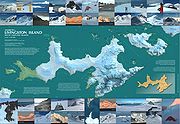
Livingston Island (South Shetland Islands)
Encyclopedia
South Shetland Islands
The South Shetland Islands are a group of Antarctic islands, lying about north of the Antarctic Peninsula, with a total area of . By the Antarctic Treaty of 1959, the Islands' sovereignty is neither recognized nor disputed by the signatories and they are free for use by any signatory for...
, Western Antarctica lying between Greenwich Island
Greenwich Island (South Shetland Islands)
Greenwich Island is an island long and from wide, lying between Robert Island and Livingston Island in the South Shetland Islands. Surface area...
and Snow Island
Snow Island (South Shetland Islands)
Snow Island or Isla Nevada is a completely ice-covered island, in size, lying southwest of Livingston Island in the South Shetland Islands. Surface area...
s. This island
Island
An island or isle is any piece of sub-continental land that is surrounded by water. Very small islands such as emergent land features on atolls can be called islets, cays or keys. An island in a river or lake may be called an eyot , or holm...
was known to sealers as early as 1819, and the name Livingston, although of unknown derivation, has been well established in international usage since the 1820s.
Geography
Southern Ocean
The Southern Ocean comprises the southernmost waters of the World Ocean, generally taken to be south of 60°S latitude and encircling Antarctica. It is usually regarded as the fourth-largest of the five principal oceanic divisions...
110 km (68 mi) to the northwest of Cape Roquemaurel on the Antarctic mainland, 809.4 km (503 mi) to the south-southeast of Cape Horn
Cape Horn
Cape Horn is the southernmost headland of the Tierra del Fuego archipelago of southern Chile, and is located on the small Hornos Island...
in South America
South America
South America is a continent situated in the Western Hemisphere, mostly in the Southern Hemisphere, with a relatively small portion in the Northern Hemisphere. The continent is also considered a subcontinent of the Americas. It is bordered on the west by the Pacific Ocean and on the north and east...
, 820 km (510 mi) to the southeast of the Diego Ramirez Islands
Diego Ramírez Islands
The Diego Ramírez Islands are a small group of lesser islands located in the southernmost extreme of Chile about south-west of Cape Horn and south-south-east of Ildefonso Islands, stretching north-south . Their land area is little more than...
(the southernmost land of South America
South America
South America is a continent situated in the Western Hemisphere, mostly in the Southern Hemisphere, with a relatively small portion in the Northern Hemisphere. The continent is also considered a subcontinent of the Americas. It is bordered on the west by the Pacific Ocean and on the north and east...
), 1000 km (621 mi) due south of the Falkland Islands
Falkland Islands
The Falkland Islands are an archipelago in the South Atlantic Ocean, located about from the coast of mainland South America. The archipelago consists of East Falkland, West Falkland and 776 lesser islands. The capital, Stanley, is on East Falkland...
, 1600 km (994 mi) to the southwest of South Georgia Island, and 3000 km (1,864 mi) from the South Pole
South Pole
The South Pole, also known as the Geographic South Pole or Terrestrial South Pole, is one of the two points where the Earth's axis of rotation intersects its surface. It is the southernmost point on the surface of the Earth and lies on the opposite side of the Earth from the North Pole...
.
The island is part of the South Shetlands archipelago, an islands chain extending over 500 km (311 mi) in east-northeast to west-southwest direction, and separated from the nearby Antarctic Peninsula
Antarctic Peninsula
The Antarctic Peninsula is the northernmost part of the mainland of Antarctica. It extends from a line between Cape Adams and a point on the mainland south of Eklund Islands....
by Bransfield Strait
Bransfield Strait
Bransfield Strait is a body of water about wide extending for in a general northeast-southwest direction between the South Shetland Islands and Antarctic Peninsula. It was named in about 1825 by James Weddell, Master, Royal Navy, for Edward Bransfield, Master, RN, who charted the South Shetland...
, and from South America
South America
South America is a continent situated in the Western Hemisphere, mostly in the Southern Hemisphere, with a relatively small portion in the Northern Hemisphere. The continent is also considered a subcontinent of the Americas. It is bordered on the west by the Pacific Ocean and on the north and east...
by the Drake Passage
Drake Passage
The Drake Passage or Mar de Hoces—Sea of Hoces—is the body of water between the southern tip of South America at Cape Horn, Chile and the South Shetland Islands of Antarctica...
. The South Shetlands cover a total land area of 3687 km² (1,424 sq mi) comprising (from east to west) Clarence Island
Clarence Island (South Shetland Islands)
Clarence Island is long and the easternmost of the South Shetland Islands of the British Antarctic Territory. The name dates back to at least 1821 and is now established in international usage. Ernest Shackleton saw Clarence Island on his famous boat voyage but landed on Elephant Island...
, Elephant Island, King George Island, Nelson Island
Nelson Island (South Shetland Islands)
Nelson Island is an island long and wide, lying southwest of King George Island in the South Shetland Islands, Antarctica. Nelson Island is located at...
, Robert Island, Greenwich Island, Livingston Island, Deception Island, Snow Island, Low Island
Low Island (South Shetland Islands)
Low Island or Isla Baja, historical names Jameson Island or Jamesons Island is an island long and wide, southeast of Smith Island, in the South Shetland Islands. The island is located at and is separated from Smith Island by Osmar Strait. Low Island was so named because of its low elevation...
and Smith Island
Smith Island (South Shetland Islands)
Smith Island is long and wide, lying west of Deception Island in the South Shetland Islands of the British Antarctic Territory. Surface area ....
, as well as numerous smaller islets and rocks.
Livingston is separated from the neighbouring Greenwich Island to the east and Snow Island to the west-southwest respectively by McFarlane Strait
McFarlane Strait
McFarlane Strait is the 24.5 km long and 3.35 km wide strait lying between Greenwich and Livingston Island, in the South Shetland Islands...
and by Morton Strait
Morton Strait
Morton Strait is the 9 km long and 6.2 km wide strait between Snow Island on the southwest and Rugged and Livingston Islands on the northeast, in the South Shetland Islands, Antarctica...
. Deception Island, located barely 18 km (11.2 mi) southwest of Livingston’s Barnard Point
Barnard Point
Barnard Point is a headland which marks the southeast side of the entrance to False Bay on the south side of Livingston Island in the South Shetland Islands, Antarctica. This point was known to sealers as early as 1822. The name was applied about a century later, probably after Mount Barnard ...
in the Bransfield Strait
Bransfield Strait
Bransfield Strait is a body of water about wide extending for in a general northeast-southwest direction between the South Shetland Islands and Antarctic Peninsula. It was named in about 1825 by James Weddell, Master, Royal Navy, for Edward Bransfield, Master, RN, who charted the South Shetland...
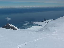
, is a volcano whose caldera
Caldera
A caldera is a cauldron-like volcanic feature usually formed by the collapse of land following a volcanic eruption, such as the one at Yellowstone National Park in the US. They are sometimes confused with volcanic craters...
forms the sheltered harbour of Port Foster
Port Foster
Port Foster is one of the safest harbours in Antarctica, located in Deception Island in the South Shetland Islands.The center of Deception Island is a caldera, formed by a gigantic volcanic eruption and later flooded. This has created the 5 miles long, 3 miles wide basin-like harbour of Port Foster...
entered by a single narrow passage known as Neptune's Bellows
Neptune's Bellows
Neptune's Bellows is a channel on the southeast side of Deception Island forming the entrance to Port Foster, in the South Shetland Islands. The name, after the Roman sea god Neptune, was appended by American sealers prior to 1822 because of the strong gusts experienced in this narrow...
.
The island extends 73 km (45 mi) from Start Point
Start Point, Livingston Island
Start Point is a point marking the northwest end of Byers Peninsula, Livingston Island in the South Shetland Islands, Antarctica and forming the southwest side of the entrance to Svishtov Cove and the northeast side of the entrance to the New Plymouth bay...
in the west to Renier Point
Renier Point
Renier Point is a narrow point forming the east extremity of both Burgas Peninsula and Livingston Island in the South Shetland Islands, Antarctica. The feature was known to sealers as Point Renier as early as 1821. The name ‘Pin Point’, given by Discovery Investigations personnel on the...
in the east, its width varying from 5 km (3.1 mi) at the neck between South Bay
South Bay, Livingston Island
South Bay is a wide bay indenting for the south coast of Livingston Island in the South Shetland Islands, Antarctica. The bay is lying northwest of False Bay and east of Walker Bay, and is entered between Hannah Point and Miers Bluff....
and Hero Bay
Hero Bay
Hero Bay is a 17 mi wide bay, which indents for 6 mi the north side of Livingston Island between Cape Shirreff and Williams Point, in the South Shetland Islands. The name ‘Blythe Bay’, originally applied to a small bay on the southeast side of Desolation Island on Powell's chart of 1822...
to 34 km (21 mi) between Botev Point
Botev Point
Botev Point is the south extremity of both Rozhen Peninsula and Livingston Island in the South Shetland Islands, Antarctica formed by an offshoot of Botev Peak in the Veleka Ridge of Tangra Mountains....
to the south and Williams Point
Williams Point
Williams Point is the point forming both the north extremity of Varna Peninsula and the northeast tip of Livingston Island in the South Shetland Islands, Antarctica...
to the north, with surface area of 798 square kilometres (308.1 sq mi). There are many islets and rocks in the surrounding waters, particularly off the north coast. More sizable among the adjacent smaller islands are Rugged Island
Rugged Island (South Shetland Islands)
Rugged Island is an island long and wide, lying west of Livingston Island in the South Shetland Islands. Surface area . The island's summit San Stefano Peak rises to above sea level. Rugged Island is located at...
off Byers Peninsula
Byers Peninsula
Byers Peninsula is a mainly ice-free peninsula forming the west end of Livingston Island in the South Shetland Islands. It occupies , and includes the small freshwater Basalt Lake. The area was visited by early 19th century American and British sealers who came almost exclusively from New England,...
(which also contain a small freshwater
Freshwater
Fresh water is naturally occurring water on the Earth's surface in ice sheets, ice caps, glaciers, bogs, ponds, lakes, rivers and streams, and underground as groundwater in aquifers and underground streams. Fresh water is generally characterized by having low concentrations of dissolved salts and...
lake named Basalt Lake
Basalt Lake
Basalt Lake is a small freshwater lake surrounded by three basalt outcrops with ‘organ-pipe’ formations in their rocks, situated in the central part of the ice-free Byers Peninsula, Livingston Island in the South Shetland Islands, Antarctica...
), Half Moon Island
Half Moon Island (South Shetland Islands)
Half Moon Island is a minor Antarctic island, lying north of Burgas Peninsula, Livingston Island in the Antarctic Peninsula region. Surface area ....
in Moon Bay
Moon Bay
Moon Bay is a 7 mi wide bay, which recedes 4 mi between Edinburgh Hill and Renier Point, on the east side of Livingston Island, in the South Shetland Islands, Antarctica. Half Moon Island is situated in the bay. Moon Bay was known to sealers in the area as early as 1821. Recharted by...
, Desolation Island
Desolation Island (South Shetland Islands)
Desolation Island is one of the minor islands in the South Shetlands archipelago, Antarctica situated at the entrance to Hero Bay, Livingston Island. The island is V-shaped with its northern coast indented by Kozma Cove. Surface area ....
in Hero Bay
Hero Bay
Hero Bay is a 17 mi wide bay, which indents for 6 mi the north side of Livingston Island between Cape Shirreff and Williams Point, in the South Shetland Islands. The name ‘Blythe Bay’, originally applied to a small bay on the southeast side of Desolation Island on Powell's chart of 1822...
and Zed Islands
Zed Islands
Zed Islands is a small group of islands, the westernmost rising to , lying off the northeast extremity of Livingston Island in the South Shetland Islands, Antarctica comprising four islands: Esperanto Island, Phanagoria Island, Lesidren Island and Koshava Island...
to the north.

Apart from the extensive Byers Peninsula
Byers Peninsula
Byers Peninsula is a mainly ice-free peninsula forming the west end of Livingston Island in the South Shetland Islands. It occupies , and includes the small freshwater Basalt Lake. The area was visited by early 19th century American and British sealers who came almost exclusively from New England,...
(61 km² (24 sq mi)) forming the west extremity of Livingston, the ice-free part of the island includes certain coastal areas at Cape Shirreff
Cape Shirreff
Cape Shirreff is a prominent cape at the north end of the rocky peninsula which separates Hero Bay and Barclay Bay on the north coast of Livingston Island, in the South Shetland Islands...
, Siddons Point
Siddons Point
Siddons Point is a point projecting into the middle of the head of Hero Bay on the north coast of Livingston Island in the South Shetland Islands, Antarctica...
, Hannah Point
Hannah Point
Hannah Point is a point on the south coast of Livingston Island in the South Shetland Islands, Antarctica. It forms the east side of the entrance to Walker Bay and the west side of the entrance to South Bay. Surmounted by Ustra Peak to the north, with Liverpool Beach extending between the peak and...
, Williams Point
Williams Point
Williams Point is the point forming both the north extremity of Varna Peninsula and the northeast tip of Livingston Island in the South Shetland Islands, Antarctica...
, Hurd Peninsula
Hurd Peninsula
Hurd Peninsula is the land between South Bay and False Bay on the south coast of Livingston Island in the South Shetland Islands, Antarctica. The Spanish Antarctic base Juan Carlos I and the Bulgarian Antarctic base St. Kliment Ohridski are situated on the west coast of the peninsula.The feature...
and Rozhen Peninsula
Rozhen Peninsula
Rozhen Peninsula extends 9 km in the southwest direction towards Barnard Point, Livingston Island in the South Shetland Islands, Antarctica, and 8.8 km wide. It is bounded by False Bay to the west, Bransfield Strait to the southeast and Brunow Bay to the east...
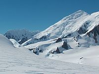
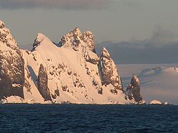
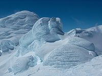
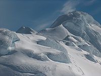
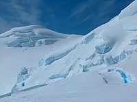
, as well as slopes in the mountain ranges, and ridges and heights in eastern Livingston that are too precipitous to keep snow. The principal mountain formations include Tangra Mountains
Tangra Mountains
Tangra Mountains form the principal mountain range of Livingston Island in the South Shetland Islands, Antarctica...
(30 km (19 mi) long, with Mt Friesland
Mount Friesland
Mount Friesland is the summit of Tangra Mountains on Livingston Island, in the South Shetland Islands, Antarctica. The peak is rising to 1700 m sharp, and is heavily glaciated and crevassed. Situated 12.5 km northeast of Barnard Point, 9.7 km east-southeast of St...
rising to 1700 m (5,577 ft)), Bowles Ridge
Bowles Ridge
Bowles Ridge is the central ridge of eastern Livingston Island. The ridge extends 6.5 km in the east-west direction and is 1.5 km wide. The summit of the ridge is Mount Bowles which rises to 822m and is located 9.77 km northwest of Great Needle Peak, 6.08 km north by west of...
(6.5 km (4 mi), elevation 822 m (2,697 ft)), Vidin Heights
Vidin Heights
Vidin Heights are predominantly ice-covered heights rising to 604 m on Varna Peninsula, eastern Livingston Island in the South Shetland Islands, Antarctica. The feature is approximately 8 km long from the north end of Leslie Gap east-northeastwards to Inott Point and 9.6 km...
(8 km (5 mi), 604 m (1,982 ft)), Burdick Ridge
Burdick Ridge
Burdick Ridge is a ridge rising to 773 m on Livingston Island in the South Shetland Islands. Extending for 1.9 km between Orpheus Gate in the southeast and Rezen Saddle in the northwest. Bounded by Perunika Glacier to the northeast, and Balkan Snowfield to the southwest. Takes its name from...
(773 m (2,536 ft)), Melnik Ridge
Melnik Ridge
Melnik Ridge is a narrow ridge rising to 696 m in eastern Livingston Island in the South Shetland Islands, Antarctica bounded by Kaliakra Glacier to the north and west, and Struma Glacier to the south, and linked to Bowles Ridge by the 575 m high Yankov Gap...
(696 m (2,283 ft)) and Pliska Ridge
Pliska Ridge
Pliska Ridge is a three-peaked ridge rising to 667 m in eastern Livingston Island in the South Shetland Islands, Antarctica...
(667 m (2,188 ft)) in the eastern part of the island, and Oryahovo Heights
Oryahovo Heights
Oryahovo Heights are the ice-covered heights of elevation 340 m extending 6 km in north-south direction in central and eastern Ioannes Paulus II Peninsula, Livingston Island in the South Shetland Islands, Antarctica...
(6 km (4 mi), 340 m (1,115 ft)), and Dospey Heights
Dospey Heights
Dospey Heights are the ice-free heights on Ray Promontory in the northwestern part of Byers Peninsula on Livingston Island in the South Shetland Islands, Antarctica. Extending 6 km southeastwards from Essex Point and Start Point, and 2.6 km wide...
(6 km (4 mi), 265 m (869 ft)).
The coastline of the island is irregular, with the more significant indentations of South Bay
South Bay, Livingston Island
South Bay is a wide bay indenting for the south coast of Livingston Island in the South Shetland Islands, Antarctica. The bay is lying northwest of False Bay and east of Walker Bay, and is entered between Hannah Point and Miers Bluff....
, False Bay
False Bay, Livingston Island
False Bay is a 4 mi long bay, which lies between Barnard Point and Miers Bluff on the south side of Livingston Island, in the South Shetland Islands, Antarctica. It was probably first entered and charted by Capt...
, Moon Bay
Moon Bay
Moon Bay is a 7 mi wide bay, which recedes 4 mi between Edinburgh Hill and Renier Point, on the east side of Livingston Island, in the South Shetland Islands, Antarctica. Half Moon Island is situated in the bay. Moon Bay was known to sealers in the area as early as 1821. Recharted by...
, Hero
Hero Bay
Hero Bay is a 17 mi wide bay, which indents for 6 mi the north side of Livingston Island between Cape Shirreff and Williams Point, in the South Shetland Islands. The name ‘Blythe Bay’, originally applied to a small bay on the southeast side of Desolation Island on Powell's chart of 1822...
, Barclay
Barclay Bay
Barclay Bay is a bay lying between Cape Shirreff and Essex Point on the north side of Livingston Island, in the South Shetland Islands. The name appears on an 1825 chart of the British sealing expedition under James Weddell, and is now established in international usage.-Maps:* L.L. Ivanov et al....
, New Plymouth
New Plymouth, Livingston Island
New Plymouth is a bay bordered by an extensive line of beaches, lying south of Start Point and between Rugged Island and the west end of Livingston Island in the South Shetland Islands, Antarctica....
, Osogovo
Osogovo Bay
Osogovo Bay , "named after the Osogovo region in western Bulgaria", is bounded by the south coast of Rugged Island, by Astor Island, and by the west coast of the Byers Peninsula south of Laager Point, Livingston Island in the South Shetland Islands, Antarctica.By sea, it is entered between Benson...
and Walker
Walker Bay, Livingston Island
Walker Bay is a bay lying between John Beach and Hannah Point along the south coast of Livingston Island in the South Shetland Islands, Antarctica...
, and the peninsulas of Hurd
Hurd Peninsula
Hurd Peninsula is the land between South Bay and False Bay on the south coast of Livingston Island in the South Shetland Islands, Antarctica. The Spanish Antarctic base Juan Carlos I and the Bulgarian Antarctic base St. Kliment Ohridski are situated on the west coast of the peninsula.The feature...
(extension 10 km (6.2 mi)), Rozhen
Rozhen Peninsula
Rozhen Peninsula extends 9 km in the southwest direction towards Barnard Point, Livingston Island in the South Shetland Islands, Antarctica, and 8.8 km wide. It is bounded by False Bay to the west, Bransfield Strait to the southeast and Brunow Bay to the east...
(9 km (5.6 mi)), Burgas
Burgas Peninsula
Burgas Peninsula is a predominantly ice-covered peninsula forming the east extremity of Livingston Island in the South Shetland Islands, Antarctica extending 10 km in the east-northeast direction towards Renier Point and 4.7 km wide...
(10.5 km (6.5 mi)), Varna
Varna Peninsula
Varna Peninsula is a roughly rectangular predominantly ice-covered peninsula forming the northeast extremity of Livingston Island in the South Shetland Islands, Antarctica...
(12 km (7.5 mi)), Ioannes Paulus II
Ioannes Paulus II Peninsula
Ioannes Paulus II Peninsula is an ice-covered peninsula on the north coast of Livingston Island in the South Shetland Islands, Antarctica that is bounded by Hero Bay to the east and Barclay Bay to the west. It extends 13 km in length in north-south direction and is 8 km wide...
(12.8 km (8 mi)) and Byers
Byers Peninsula
Byers Peninsula is a mainly ice-free peninsula forming the west end of Livingston Island in the South Shetland Islands. It occupies , and includes the small freshwater Basalt Lake. The area was visited by early 19th century American and British sealers who came almost exclusively from New England,...
(15 km (9.3 mi)).
The local variety of the Antarctic Peninsula
Antarctic Peninsula
The Antarctic Peninsula is the northernmost part of the mainland of Antarctica. It extends from a line between Cape Adams and a point on the mainland south of Eklund Islands....
weather is particularly changeable, windy, humid and sunless. Says Australian mountaineer Damien Gildea
Damien Gildea
Damien Gildea is an Australian mountaineer and Antarctic explorer who climbed extensively in Antarctica, Nepal, Tibet, Pakistan, Bolivia, Alaska, New Zealand and elsewhere...
: ‘Livingston got just about the worst weather in the world’. Whiteouts are common, and blizzards can occur at any time of the year. Temperatures are rather constant, rarely exceeding 3 °C (37.4 °F) in summer or falling below −11 °C in winter, with wind chill temperatures up to 5 C-change to 10 C-change lower.
Below are the average temperatures of the warmest month, coldest month, yearly average, and the average annual rainfall of Livingston Island.
| Place | Average: Warmest month °C/°F | Average: Coldest month °C/°F | Annual average °C/°F | Average annual rainfall mostly in snow mm/in |
|---|---|---|---|---|
| Livingston Island (coastal areas) | 1.3 °C (34.3 °F) | −7 °C | −2.7 °C | 800 mm (31.5 in) |
|}
History

William Smith (mariner)
William Smith was the English captain who discovered the South Shetland Islands, an archipelago off the Graham Land in Antarctica....
in the English merchant brig Williams, while sailing to Valparaiso
Valparaíso
Valparaíso is a city and commune of Chile, center of its third largest conurbation and one of the country's most important seaports and an increasing cultural center in the Southwest Pacific hemisphere. The city is the capital of the Valparaíso Province and the Valparaíso Region...
during 1819 deviated from his route south of Cape Horn
Cape Horn
Cape Horn is the southernmost headland of the Tierra del Fuego archipelago of southern Chile, and is located on the small Hornos Island...
, and on 19 February sighted the northeast extremity of Livingston, Williams Point
Williams Point
Williams Point is the point forming both the north extremity of Varna Peninsula and the northeast tip of Livingston Island in the South Shetland Islands, Antarctica...
.

United Kingdom of Great Britain and Ireland
The United Kingdom of Great Britain and Ireland was the formal name of the United Kingdom during the period when what is now the Republic of Ireland formed a part of it....
. In the meantime, a Spanish vessel had been damaged by severe weather in the Drake Passage
Drake Passage
The Drake Passage or Mar de Hoces—Sea of Hoces—is the body of water between the southern tip of South America at Cape Horn, Chile and the South Shetland Islands of Antarctica...
and sunk off the north coast of Livingston in September 1819. The 74-gun ship San Telmo
San Telmo (ship)
San Telmo was a Spanish 74-gun ship of the line, launched in 1788.In 1819 the San Telmo commanded by Captain Rosendo Porlier was the flagship of a Spanish naval squadron bound for Callao to reinforce colonial forces there fighting the independence movements in Spanish America...
commanded by Captain Rosendo Porlier was the flagship of a Spanish naval squadron. The more than 600 persons killed when the San Telmo sank were the first recorded people to die in Antarctica. While no one survived, parts of her wreckage were found subsequently by sealers on Half Moon Beach
Half Moon Beach, Livingston Island
Half Moon Beach is the 1 km crescent-shaped beach at the west extremity of Porlier Bay in the north of Ioannes Paulus II Peninsula, Livingston Island in the South Shetland Islands, Antarctica...
, Cape Shirreff
Cape Shirreff
Cape Shirreff is a prominent cape at the north end of the rocky peninsula which separates Hero Bay and Barclay Bay on the north coast of Livingston Island, in the South Shetland Islands...
.
During December 1819 William Smith
William Smith (mariner)
William Smith was the English captain who discovered the South Shetland Islands, an archipelago off the Graham Land in Antarctica....
returned with his ship to the South Shetlands. This time he was chartered by Captain William Shirreff
William Shirreff
William Shirreff was a Royal Navy officer, Captain of the frigate HMS Andromache patrolling the west coast of South America in protection of the British interests in the region and support of local independence movement against Spanish authority in the early 19th century...
, British commanding officer in the Pacific stationed in Chile
Chile
Chile ,officially the Republic of Chile , is a country in South America occupying a long, narrow coastal strip between the Andes mountains to the east and the Pacific Ocean to the west. It borders Peru to the north, Bolivia to the northeast, Argentina to the east, and the Drake Passage in the far...
, and accompanied by Lieutenant Edward Bransfield
Edward Bransfield
Edward Bransfield was a master of the British Royal Navy and considered the discoverer of the continent of Antarctica.-Early life:...
who was tasked to survey and map the new lands.
On 30 January 1820 they sighted the mountains of the Antarctic Peninsula
Antarctic Peninsula
The Antarctic Peninsula is the northernmost part of the mainland of Antarctica. It extends from a line between Cape Adams and a point on the mainland south of Eklund Islands....
, unaware that three days earlier the continent had already been discovered by the Russian Antarctic expedition of Fabian Gottlieb Thaddeus von Bellingshausen
Fabian Gottlieb von Bellingshausen
Fabian Gottlieb Thaddeus von Bellingshausen was an officer in the Imperial Russian Navy, cartographer and explorer, who ultimately rose to the rank of Admiral...
and Mihail Lazarev
Mikhail Petrovich Lazarev
Admiral Mikhail Petrovich Lazarev was a Russian fleet commander and explorer who discovered Antarctica.-Education and early career:Lazarev was born in Vladimir, a scion of the old Russian nobility from the Vladimir province. In 1800, he enrolled in Russia's Naval College. Three years later he...
.
One year later, the Russians had circumnavigated Antarctica and arrived in the South Shetlands region during January 1821 to find over 50 American and English sealing vessels and 1000 men taking hundreds of thousands of fur seal skins. While sailing between Deception Island and Livingston (named Smolensk
Smolensk
Smolensk is a city and the administrative center of Smolensk Oblast, Russia, located on the Dnieper River. Situated west-southwest of Moscow, this walled city was destroyed several times throughout its long history since it was on the invasion routes of both Napoleon and Hitler. Today, Smolensk...
by the Russians) Bellingshausen met the American Captain Nathaniel Palmer
Nathaniel Palmer
Nathaniel Brown Palmer was an American seal hunter, explorer, sailing captain, and ship designer. He was born in Stonington, Connecticut.-Sealing career and Antarctic exploration:...
, yet another pioneer of Antarctic exploration who is alleged to have sighted the mainland himself during the previous November.
Castaway depot
A castaway depot is a store or hut placed on an isolated island to provide emergency supplies and relief for castaways and victims of shipwrecks...
and sealer artefacts are still found on Livingston, which possesses the second greatest concentration of historical sites in Antarctica (after South Georgia
South Georgia and the South Sandwich Islands
South Georgia and the South Sandwich Islands is a British overseas territory and overseas territory of the European Union in the southern Atlantic Ocean. It is a remote and inhospitable collection of islands, consisting of South Georgia and a chain of smaller islands, known as the South Sandwich...
). The names of many geographical features on the island also refer to its early history. Among the commemorated are ship captains such as the Americans Christopher Burdick, Charles Barnard, Robert Johnson, Donald MacKay, Robert Inott, David Leslie, Benjamin Brunow, Robert Macy, Prince Moores and William Napier, the Britons William Shirreff, M’Kean, John Walker, Ralph Bond, Christopher MacGregor, T. Binn and William Bowles, the Australian Richard Siddons, people like the New York shipowner James Byers
James Byers
James Byers was a New York shipowner, merchant and sealer, who sent a four-vessel sealing fleet to the South Shetland Islands in 1820-21. Byers also lobbied US Secretary of State John Quincy Adams and President James Monroe to send a warship and take possession of the islands, suggesting that the...
, the American whaling merchants William and Francis Rotch, British Admiralty hydrographer Thomas Hurd, and John Miers, publisher of the first chart of the South Shetland Islands
South Shetland Islands
The South Shetland Islands are a group of Antarctic islands, lying about north of the Antarctic Peninsula, with a total area of . By the Antarctic Treaty of 1959, the Islands' sovereignty is neither recognized nor disputed by the signatories and they are free for use by any signatory for...
based on the work of William Smith
William Smith (mariner)
William Smith was the English captain who discovered the South Shetland Islands, an archipelago off the Graham Land in Antarctica....
, or sealing vessels like Huron, Williams, Samuel, Gleaner, Huntress, Charity, Hannah, Henry, John, Hero and others.
Some of the place names given by the nineteenth century sealers are descriptive, such as Devils Point
Devils Point
Devils Point is a point marking the southwest extremity of Byers Peninsula, Livingston Island in the South Shetland Islands, Antarctica and forming the southeast side of the entrance to Osogovo Bay and the west side of the entrance to Raskuporis Cove...
, Hell Gates
Hell Gates
Hell Gates is a narrow boat passage between Vardim Rocks and Devils Point on Byers Peninsula, at the southwest end of Livingston Island in the South Shetland Islands. The name dates back to about 1821 and was applied by early sealers in the area because many lives and ships were lost here.-Map:*...
and Neck or Nothing Passage
Neck or Nothing Passage
Neck or Nothing Passage is a narrow passage leading from Blythe Bay between Iratais Point in the south end of Desolation Island and Miladinovi Islets, in the South Shetland Islands. The name was applied prior to 1830, probably by whalers who frequented Blythe Bay and who at times ran their...
, hazardous places where ships and people were lost; Inept Cove
Inept Cove
Inept Cove is a cove on the east side of False Bay, Livingston Island in the South Shetland Islands. The feature was named Caleta Inepta on a 1954 Argentine navy chart, reflecting the inadequacy of the cove as an anchorage. The name has been approved with an English generic term.-Map:* L.L...
, Needle Peak, or the Robbery Beaches
Robbery Beaches
Robbery Beaches are beaches extending along the north side of Byers Peninsula, Livingston Island in the South Shetland Islands, Antarctica between Essex Point to the west and Nedelya Point to the east....
where American sealers were robbed of their sealskins by the British. However, names like Livingston, Mount Friesland
Mount Friesland
Mount Friesland is the summit of Tangra Mountains on Livingston Island, in the South Shetland Islands, Antarctica. The peak is rising to 1700 m sharp, and is heavily glaciated and crevassed. Situated 12.5 km northeast of Barnard Point, 9.7 km east-southeast of St...
and Renier Point
Renier Point
Renier Point is a narrow point forming the east extremity of both Burgas Peninsula and Livingston Island in the South Shetland Islands, Antarctica. The feature was known to sealers as Point Renier as early as 1821. The name ‘Pin Point’, given by Discovery Investigations personnel on the...
also became established during the first few seasons after the discovery of the islands, yet their particular origins remain unknown.
Scientific bases
The first modern, 'post-sealer' habitation facility on Livingston Island was the British base camp Station PStation P
Station P was a British base camp on the east side of Hannah Point, Livingston Island in the South Shetland Islands, Antarctica that supported survey, geology and biology field work from 29 December 1957 until 15 March 1958...
that operated in Hannah Point
Hannah Point
Hannah Point is a point on the south coast of Livingston Island in the South Shetland Islands, Antarctica. It forms the east side of the entrance to Walker Bay and the west side of the entrance to South Bay. Surmounted by Ustra Peak to the north, with Liverpool Beach extending between the peak and...
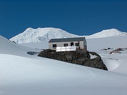
area during the 1957/58 summer season. The permanent scientific bases of Juan Carlos I
Juan Carlos I Base
Juan Carlos I Antarctic Base, named after the king of Spain, Juan Carlos I, is a seasonal scientific station operated by Spain, opened in January 1988...
(Spain
Spain
Spain , officially the Kingdom of Spain languages]] under the European Charter for Regional or Minority Languages. In each of these, Spain's official name is as follows:;;;;;;), is a country and member state of the European Union located in southwestern Europe on the Iberian Peninsula...
) and St. Kliment Ohridski
St. Kliment Ohridski Base
St. Kliment Ohridski Base is a Bulgarian Antarctic base on Livingston Island in the South Shetland Islands.The base, originally known as Sofia University Refuge, was named in 1993 "for St...
(Bulgaria
Bulgaria
Bulgaria , officially the Republic of Bulgaria , is a parliamentary democracy within a unitary constitutional republic in Southeast Europe. The country borders Romania to the north, Serbia and Macedonia to the west, Greece and Turkey to the south, as well as the Black Sea to the east...
) were established in 1988 at South Bay. Other base facilities are the small Shirreff Base
Shirreff Base
Shirreff Base is a seasonal field station operated by Chile and the USA opened in 1991. Situated on the east side of Cape Shirreff on Ioannes Paulus II Peninsula on Livingston Island in the South Shetland Islands.-Location:...
(or Guillermo Mann, Chile
Chile
Chile ,officially the Republic of Chile , is a country in South America occupying a long, narrow coastal strip between the Andes mountains to the east and the Pacific Ocean to the west. It borders Peru to the north, Bolivia to the northeast, Argentina to the east, and the Drake Passage in the far...
and the U.S.A.) on Cape Shirreff
Cape Shirreff
Cape Shirreff is a prominent cape at the north end of the rocky peninsula which separates Hero Bay and Barclay Bay on the north coast of Livingston Island, in the South Shetland Islands...
since 1991, and the summer base Cámara
Cámara Base
Cámara Base is a seasonal station operated by Argentina opened in 1953. Situated on Half Moon Island in McFarlane Strait off the east coast of Livingston Island in the South Shetland Islands, Antarctica....
(Argentina
Argentina
Argentina , officially the Argentine Republic , is the second largest country in South America by land area, after Brazil. It is constituted as a federation of 23 provinces and an autonomous city, Buenos Aires...
) on nearby Half Moon Island
Half Moon Island (South Shetland Islands)
Half Moon Island is a minor Antarctic island, lying north of Burgas Peninsula, Livingston Island in the Antarctic Peninsula region. Surface area ....
since 1953.
Camp Byers
Camp Byers is a Spanish seasonal base camp on Byers Peninsula, Livingston Island in the South Shetland Islands, Antarctica. The area was visited by early 19th century sealers.-Location:...
(Spain
Spain
Spain , officially the Kingdom of Spain languages]] under the European Charter for Regional or Minority Languages. In each of these, Spain's official name is as follows:;;;;;;), is a country and member state of the European Union located in southwestern Europe on the Iberian Peninsula...
) operates regularly near Nikopol Point
Nikopol Point
Nikopol Point is a snow-free point on the south coast of Byers Peninsula, Livingston Island in the South Shetland Islands, Antarctica projecting 650 m into Bransfield Strait and linked by a spit to Vietor Rock to the south...
on Byers Peninsula, the seasonal Camp Livingston
Camp Livingston (Antarctica)
Camp Livingston is an Argentine seasonal base camp on Byers Peninsula, Livingston Island in the South Shetland Islands, Antarctica. The area was visited by early 19th century sealers.-Location:...
(Argentina
Argentina
Argentina , officially the Argentine Republic , is the second largest country in South America by land area, after Brazil. It is constituted as a federation of 23 provinces and an autonomous city, Buenos Aires...
) is also situated on Byers Peninsula, and the Camp Academia
Camp Academia
Camp Academia is a geographical locality in eastern Livingston Island, South Shetland Islands, Antarctica, named for the Bulgarian Academy of Sciences in appreciation of Academy’s contribution to the Antarctic exploration...
site situated at elevation 541 m (1,775 ft) in upper Huron Glacier
Huron Glacier
Huron Glacier is a 7.7 km long and 3.5 km wide glacial flow on Livingston Island in the South Shetland Islands, Antarctica. The glacier is bounded by Bowles Ridge to the north, Wörner Gap to the west and Tangra Mountains to the south, receiving ice influx from several tributary glaciers...
, Wörner Gap
Wörner Gap
Wörner Gap is a flat saddle extending 3 km in the south-north direction between Friesland Ridge and Bowles Ridge in eastern Livingston Island in the South Shetland Islands, Antarctica. Its elevation decreases from 585 m in the south to 541 m in the middle, and 525 m in the north...
area served as a base camp of the Tangra 2004/05
Tangra 2004/05
The Tangra 2004/05 Expedition was commissioned by the Antarctic Place-names Commission at the Ministry of Foreign Affairs of Bulgaria, managed by the Manfred Wörner Foundation, and supported by the Bulgarian Antarctic Institute, the Institute of Mathematics and Informatics at the Bulgarian Academy...
topographic survey. Camp Academia
Camp Academia
Camp Academia is a geographical locality in eastern Livingston Island, South Shetland Islands, Antarctica, named for the Bulgarian Academy of Sciences in appreciation of Academy’s contribution to the Antarctic exploration...
is accessible by 11–12.5 km (6.8–7.8 mi) routes from St. Kliment Ohridski
St. Kliment Ohridski Base
St. Kliment Ohridski Base is a Bulgarian Antarctic base on Livingston Island in the South Shetland Islands.The base, originally known as Sofia University Refuge, was named in 1993 "for St...
and Juan Carlos I
Juan Carlos I Base
Juan Carlos I Antarctic Base, named after the king of Spain, Juan Carlos I, is a seasonal scientific station operated by Spain, opened in January 1988...
respectively, and offers convenient overland access to Tangra Mountains
Tangra Mountains
Tangra Mountains form the principal mountain range of Livingston Island in the South Shetland Islands, Antarctica...
to the south; Bowles Ridge
Bowles Ridge
Bowles Ridge is the central ridge of eastern Livingston Island. The ridge extends 6.5 km in the east-west direction and is 1.5 km wide. The summit of the ridge is Mount Bowles which rises to 822m and is located 9.77 km northwest of Great Needle Peak, 6.08 km north by west of...
, Vidin Heights
Vidin Heights
Vidin Heights are predominantly ice-covered heights rising to 604 m on Varna Peninsula, eastern Livingston Island in the South Shetland Islands, Antarctica. The feature is approximately 8 km long from the north end of Leslie Gap east-northeastwards to Inott Point and 9.6 km...
, Kaliakra Glacier
Kaliakra Glacier
Kaliakra Glacier is a glacier in northeastern Livingston Island, Antarctica extending 7 km in east-west direction and 8 km in north-south direction...
and Saedinenie Snowfield
Saedinenie Snowfield
Saedinenie Snowfield on Livingston Island in the South Shetland Islands, Antarctica, is bounded by Teres Ridge to the west, the glacial divide between the Drake Passage and Bransfield Strait to the south, Gleaner Heights, Elhovo Gap and Leslie Hill to the southeast, and Leslie Gap and Vidin...
areas to the north; Huron Glacier
Huron Glacier
Huron Glacier is a 7.7 km long and 3.5 km wide glacial flow on Livingston Island in the South Shetland Islands, Antarctica. The glacier is bounded by Bowles Ridge to the north, Wörner Gap to the west and Tangra Mountains to the south, receiving ice influx from several tributary glaciers...
to the east; and Perunika Glacier
Perunika Glacier
Perunika Glacier is an 8 km long and 3 km wide roughly crescent-shaped glacier in eastern Livingston Island in the South Shetland Islands, Antarctica....
and Huntress Glacier
Huntress Glacier
Huntress Glacier is a 7 km long and 3.7 km wide glacier on Livingston Island in the South Shetland Islands, Antarctica bounded by Friesland Ridge, Tangra Mountains to the southeast, Nesebar Gap, Pliska Ridge, Burdick Ridge and Willan Nunatak to the north, and Charrúa Gap and Napier Peak...
to the west. Camp Academia
Camp Academia
Camp Academia is a geographical locality in eastern Livingston Island, South Shetland Islands, Antarctica, named for the Bulgarian Academy of Sciences in appreciation of Academy’s contribution to the Antarctic exploration...
was named for the Bulgarian Academy of Sciences
Bulgarian Academy of Sciences
The Bulgarian Academy of Sciences is the National Academy of Bulgaria, established in 1869. The Academy is autonomous and has a Society of Academicians, Correspondent Members and Foreign Members...
in appreciation of Academy’s contribution to the Antarctic exploration, and has been designated as the summer post office Tangra 1091 of the Bulgarian Posts
Bulgarian Posts
The Bulgarian Posts are the national postal service of Bulgaria. The company was founded after the Liberation of Bulgaria from Ottoman rule, as the Russians handed all the post and telegraph offices to the newly-restored Bulgarian state on 14 May 1879...
since 2004. A US seasonal field camp on Byers Peninsula was wrecked by storm and emergency evacuated in February 2009.
Protected areas
There have been two such nature reserve
Nature reserve
A nature reserve is a protected area of importance for wildlife, flora, fauna or features of geological or other special interest, which is reserved and managed for conservation and to provide special opportunities for study or research...
s on Livingston Island since 1966, comprising respectively the extensive Byers Peninsula
Byers Peninsula
Byers Peninsula is a mainly ice-free peninsula forming the west end of Livingston Island in the South Shetland Islands. It occupies , and includes the small freshwater Basalt Lake. The area was visited by early 19th century American and British sealers who came almost exclusively from New England,...
, and the small peninsula of Cape Shirreff
Cape Shirreff
Cape Shirreff is a prominent cape at the north end of the rocky peninsula which separates Hero Bay and Barclay Bay on the north coast of Livingston Island, in the South Shetland Islands...
together with San Telmo Island
San Telmo Island
San Telmo Island is an island forming the west side of Shirreff Cove on the northwest coast of Ioannes Paulus II Peninsula, Livingston Island in the South Shetland Islands, Antarctica...
and adjacent waters.
Subject of protection are the fossils demonstrating the link between Antarctica and other austral continents
Gondwana
In paleogeography, Gondwana , originally Gondwanaland, was the southernmost of two supercontinents that later became parts of the Pangaea supercontinent. It existed from approximately 510 to 180 million years ago . Gondwana is believed to have sutured between ca. 570 and 510 Mya,...
, a variety of abundant flora and fauna including colonies of seals and penguins that are the subject of scientific study and monitoring, as well as numerous historical monuments dating from the nineteenth century.
Tourism

Tourism
Tourism is travel for recreational, leisure or business purposes. The World Tourism Organization defines tourists as people "traveling to and staying in places outside their usual environment for not more than one consecutive year for leisure, business and other purposes".Tourism has become a...
was initiated in 1958 in the South Shetland Islands
South Shetland Islands
The South Shetland Islands are a group of Antarctic islands, lying about north of the Antarctic Peninsula, with a total area of . By the Antarctic Treaty of 1959, the Islands' sovereignty is neither recognized nor disputed by the signatories and they are free for use by any signatory for...
. Since then the number of tourists visiting Antarctica has grown to tens of thousands annually, of whom over 95% tour the South Shetlands and the nearby Antarctic Peninsula
Antarctic Peninsula
The Antarctic Peninsula is the northernmost part of the mainland of Antarctica. It extends from a line between Cape Adams and a point on the mainland south of Eklund Islands....
. Hannah Point
Hannah Point
Hannah Point is a point on the south coast of Livingston Island in the South Shetland Islands, Antarctica. It forms the east side of the entrance to Walker Bay and the west side of the entrance to South Bay. Surmounted by Ustra Peak to the north, with Liverpool Beach extending between the peak and...
on the south coast of Livingston and Half Moon Island
Half Moon Island (South Shetland Islands)
Half Moon Island is a minor Antarctic island, lying north of Burgas Peninsula, Livingston Island in the Antarctic Peninsula region. Surface area ....
off the east coast, as well as the nearby Deception Island and the Aitcho Islands near Greenwich Island are among the most popular destinations frequented by cruise ship
Cruise ship
A cruise ship or cruise liner is a passenger ship used for pleasure voyages, where the voyage itself and the ship's amenities are part of the experience, as well as the different destinations along the way...
s, offering walks amidst spectacular scenery and amazing wildlife
Wildlife
Wildlife includes all non-domesticated plants, animals and other organisms. Domesticating wild plant and animal species for human benefit has occurred many times all over the planet, and has a major impact on the environment, both positive and negative....
.
Honour
Several squares and streets in Bulgarian towns and cities are named after Livingston Island, such as Livingston Island Square in SamuilSamuil (village)
Samuil is a village in northeastern Bulgaria, part of Razgrad Province, located in the geographic region of Ludogorie. It is the administrative centre of the homonymous Samuil Municipality, which lies in the southeastern part of the Province...
and Kula
Kula, Bulgaria
Kula is a town in northwestern Bulgaria. It is the administrative centre of Kula Municipality part of Vidin Province. Located just east of the Serbian-Bulgarian border, it is the third largest town in the province after Vidin and Belogradchik. Kula lies 30 kilometres west of Vidin and 13...
, and Livingston Island Street in Gotse Delchev
Gotse Delchev (town)
Gotse Delchev , is a town in Blagoevgrad Province of Bulgaria with a population of 23,573.In 1951 the town was renamed after the Bulgarian revolutionary Georgi Nikolov Delchev. It had hitherto been called Nevrokop ....
, Yambol
Yambol
Yambol is a city in southeastern Bulgaria, an administrative centre of Yambol Province. It lies on both banks of the Tundzha river in the historical region of Thrace. As of February 2011, the town has a population of 72,843 inhabitants. It is occasionally spelt 'Jambol'.The administrative centres...
, Petrich
Petrich
Petrich is a town in Blagoevgrad Province in southwestern Bulgaria, located at the foot of the Belasica Mountains in the Strumeshnitsa Valley. , the town has 29920 inhabitants.Petrich is located close to the borders with Greece and the Republic of Macedonia...
, Sofia
Sofia
Sofia is the capital and largest city of Bulgaria and the 12th largest city in the European Union with a population of 1.27 million people. It is located in western Bulgaria, at the foot of Mount Vitosha and approximately at the centre of the Balkan Peninsula.Prehistoric settlements were excavated...
, Lovech
Lovech
Lovech is a town in north-central Bulgaria with a population of 36,296 as of February 2011. It is the administrative centre of the Lovech Province and of the subordinate Lovech Municipality. The town is located about 150 km northeast from the capital city of Sofia...
and Vidin
Vidin
Vidin is a port town on the southern bank of the Danube in northwestern Bulgaria. It is close to the borders with Serbia and Romania, and is also the administrative centre of Vidin Province, as well as of the Metropolitan of Vidin...
.
See also
- Antarctic Place-names CommissionAntarctic Place-names CommissionThe Antarctic Place-names Commission was established by the Bulgarian Antarctic Institute in 1994, and since 2001 has been a body affiliated to the Ministry of Foreign Affairs of Bulgaria. The Commission approves Bulgarian place names in Antarctica, which are formally given by the President of the...
- Bulgarian toponyms in Antarctica
- Camp AcademiaCamp AcademiaCamp Academia is a geographical locality in eastern Livingston Island, South Shetland Islands, Antarctica, named for the Bulgarian Academy of Sciences in appreciation of Academy’s contribution to the Antarctic exploration...
- Camp ByersCamp ByersCamp Byers is a Spanish seasonal base camp on Byers Peninsula, Livingston Island in the South Shetland Islands, Antarctica. The area was visited by early 19th century sealers.-Location:...
- Composite Antarctic Gazetteer
- Juan Carlos I BaseJuan Carlos I BaseJuan Carlos I Antarctic Base, named after the king of Spain, Juan Carlos I, is a seasonal scientific station operated by Spain, opened in January 1988...
- List of Antarctic and sub-Antarctic islands
- List of Antarctic islands south of 60° S
- Montana BluffMontana BluffMontana Bluff is an ice-covered peak rising to 670 m at the end of a side ridge running south-southeast from Ticha Peak in central Bowles Ridge, Livingston Island. Surmounting Perunika Glacier to the west and southwest, and Huron Glacier to the east and southeast...
- SCARScientific Committee on Antarctic ResearchThe Scientific Committee on Antarctic Research is an interdisciplinary body of the International Council for Science . It was established in February 1958 to continue the international coordination of Antarctic scientific activities that had begun during the International Geophysical Year of 1957-58...
- South Shetland IslandsSouth Shetland IslandsThe South Shetland Islands are a group of Antarctic islands, lying about north of the Antarctic Peninsula, with a total area of . By the Antarctic Treaty of 1959, the Islands' sovereignty is neither recognized nor disputed by the signatories and they are free for use by any signatory for...
- St. Kliment Ohridski BaseSt. Kliment Ohridski BaseSt. Kliment Ohridski Base is a Bulgarian Antarctic base on Livingston Island in the South Shetland Islands.The base, originally known as Sofia University Refuge, was named in 1993 "for St...
- Tangra MountainsTangra MountainsTangra Mountains form the principal mountain range of Livingston Island in the South Shetland Islands, Antarctica...
- Tangra 2004/05 ExpeditionTangra 2004/05The Tangra 2004/05 Expedition was commissioned by the Antarctic Place-names Commission at the Ministry of Foreign Affairs of Bulgaria, managed by the Manfred Wörner Foundation, and supported by the Bulgarian Antarctic Institute, the Institute of Mathematics and Informatics at the Bulgarian Academy...
- Territorial claims in Antarctica