

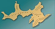
Varna Peninsula
Encyclopedia
South Shetland Islands
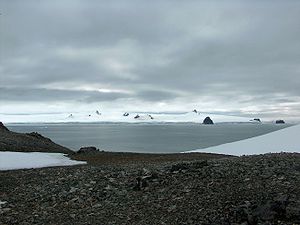
The South Shetland Islands are a group of Antarctic islands, lying about north of the Antarctic Peninsula, with a total area of . By the Antarctic Treaty of 1959, the Islands' sovereignty is neither recognized nor disputed by the signatories and they are free for use by any signatory for...
, Antarctica. It is bounded by Hero Bay
Hero Bay
Hero Bay is a 17 mi wide bay, which indents for 6 mi the north side of Livingston Island between Cape Shirreff and Williams Point, in the South Shetland Islands. The name ‘Blythe Bay’, originally applied to a small bay on the southeast side of Desolation Island on Powell's chart of 1822...
to the northwest, by Moon Bay
Moon Bay
Moon Bay is a 7 mi wide bay, which recedes 4 mi between Edinburgh Hill and Renier Point, on the east side of Livingston Island, in the South Shetland Islands, Antarctica. Half Moon Island is situated in the bay. Moon Bay was known to sealers in the area as early as 1821. Recharted by...
to the southeast, and by McFarlane Strait
McFarlane Strait
McFarlane Strait is the 24.5 km long and 3.35 km wide strait lying between Greenwich and Livingston Island, in the South Shetland Islands...
to the northeast.
The peninsula is approximately 14 km long in the southwest-northeast direction and 10 km wide, with a central area occupied by Vidin Heights
Vidin Heights
Vidin Heights are predominantly ice-covered heights rising to 604 m on Varna Peninsula, eastern Livingston Island in the South Shetland Islands, Antarctica. The feature is approximately 8 km long from the north end of Leslie Gap east-northeastwards to Inott Point and 9.6 km...
. The north and east extremities of Varna Peninsula are formed by Williams Point
Williams Point
Williams Point is the point forming both the north extremity of Varna Peninsula and the northeast tip of Livingston Island in the South Shetland Islands, Antarctica...
and by Inott Point
Inott Point
Inott Point is a point 1.1 mile north-northeast of Edinburgh Hill on the east coast of Livingston Island in the South Shetland Islands, Antarctica...
respectively. The coast is indented by Lister Cove and Dragon Cove
Dragon Cove
Dragon Cove is a 550 m wide cove indenting for 600 m the northeast coast of Varna Peninsula, Livingston Island in the South Shetland Islands, Antarctica entered between Sigritsa Point and Ficheto Point. Surmounted by Sayer Nunatak on the southwest...
to the northeast, and by Griffin Cove
Griffin Cove
Griffin Cove is the 800 m wide cove indenting for 260 m the northwest coast of Varna Peninsula, Livingston Island in the South Shetland Islands, Antarctica and entered between Gargoyle Bastion to the northeast and Organpipe Point to the southwest....
, Charybdis Cove
Charybdis Cove
Charybdis Cove is the 1.2 km wide cove indenting for 580 m the northwest coast of Varna Peninsula, Livingston Island in the South Shetland Islands, Antarctica and entered between Organpipe Point to the north and Slab Point to the south....
and Eliseyna Cove
Eliseyna Cove
Eliseyna Cove is a 3 km wide cove indenting for 1.4 km in the northwest coast of Varna Peninsula between Slab Point to the north and Kotis Point to the south...
to the northwest. Bezmer Point
Bezmer Point
Bezmer Point is on the northwest coast of the Varna Peninsula on Livingston Island in the South Shetland Islands, Antarctica. The point is situated 9.6 km east-northeast of Siddons Point and 3 km southwest of Kotis Point and 4.9 km west-southwest of Miziya Peak...
is also on the northwest coast of the peninsula.
The area was visited by early 19th century sealers
Seal hunting
Seal hunting, or sealing, is the personal or commercial hunting of seals. The hunt is currently practiced in five countries: Canada, where most of the world's seal hunting takes place, Namibia, the Danish region of Greenland, Norway and Russia...
. Williams Point was the first land discovered in the Antarctic Treaty area, by the British navigator William Smith
William Smith (mariner)
William Smith was the English captain who discovered the South Shetland Islands, an archipelago off the Graham Land in Antarctica....
on 19 February 1819.
Varna
Varna
Varna is the largest city and seaside resort on the Bulgarian Black Sea Coast and third-largest in Bulgaria after Sofia and Plovdiv, with a population of 334,870 inhabitants according to Census 2011...
is the name of a major city on the Bulgarian Black Sea Coast
Bulgarian Black Sea Coast
The Bulgarian Black Sea Coast covers the entire eastern bound of Bulgaria stretching from the Romanian Black Sea resorts in the north to European Turkey in the south, along 378 km of coastline. White and golden sandy beaches occupy approximately 130 km of the 378 km long coast...
. This is one of the Bulgarian names bestowed on hitherto nameless geographical features by the Tangra 2004/05
Tangra 2004/05
The Tangra 2004/05 Expedition was commissioned by the Antarctic Place-names Commission at the Ministry of Foreign Affairs of Bulgaria, managed by the Manfred Wörner Foundation, and supported by the Bulgarian Antarctic Institute, the Institute of Mathematics and Informatics at the Bulgarian Academy...
Expedition.
Location
The midpoint is located at 62°30′55"S 60°09′45"W (British mapping in 1822 and 1968, Chilean in 1971, Argentine in 1980, Spanish mapping in 1991, and Bulgarian topographic survey Tangra 2004/05Tangra 2004/05
The Tangra 2004/05 Expedition was commissioned by the Antarctic Place-names Commission at the Ministry of Foreign Affairs of Bulgaria, managed by the Manfred Wörner Foundation, and supported by the Bulgarian Antarctic Institute, the Institute of Mathematics and Informatics at the Bulgarian Academy...
and mapping in 2005 and 2009).
Maps
- L.L. Ivanov et al. Antarctica: Livingston Island and Greenwich Island, South Shetland Islands. Scale 1:100000 topographic map. Sofia: Antarctic Place-names Commission of Bulgaria, 2005.
- L.L. Ivanov. Antarctica: Livingston Island and Greenwich, Robert, Snow and Smith Islands. Scale 1:120000 topographic map. Troyan: Manfred Wörner Foundation, 2009. ISBN 978-954-92032-6-4