

Neck or Nothing Passage
Encyclopedia
Blythe Bay
Blythe Bay is an anchorage at the southeast side of Desolation Island, lying north of Livingston Island in the South Shetland Islands, Antarctica. The bay is bounded by Craggy Island to the northeast, Desolation Island to the northwest, the Miladinovi Islets to the west and Wood Island to the...
between Iratais Point
Iratais Point
Iratais Point is a point forming both the south extremity and the vertex of the V-shaped Desolation Island situated in the entrance to Hero Bay, Livingston Island, Antarctica...
in the south end of Desolation Island
Desolation Island (South Shetland Islands)
Desolation Island is one of the minor islands in the South Shetlands archipelago, Antarctica situated at the entrance to Hero Bay, Livingston Island. The island is V-shaped with its northern coast indented by Kozma Cove. Surface area ....
and Miladinovi Islets
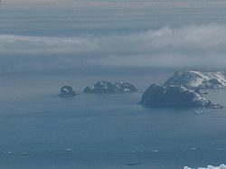
Miladinovi Islets
Miladinovi Islets is a group of two small rocky islands, , and respectively, situated south of Iratais Point on Desolation Island off the north coast of Livingston Island, Antarctica. The islands are separated from Desolation Island by Neck or Nothing Passage...
, in the South Shetland Islands
South Shetland Islands
The South Shetland Islands are a group of Antarctic islands, lying about north of the Antarctic Peninsula, with a total area of . By the Antarctic Treaty of 1959, the Islands' sovereignty is neither recognized nor disputed by the signatories and they are free for use by any signatory for...
. The name was applied prior to 1830, probably by whalers who frequented Blythe Bay
Blythe Bay
Blythe Bay is an anchorage at the southeast side of Desolation Island, lying north of Livingston Island in the South Shetland Islands, Antarctica. The bay is bounded by Craggy Island to the northeast, Desolation Island to the northwest, the Miladinovi Islets to the west and Wood Island to the...
and who at times ran their vessels to sea via this passage to escape severe easterly gales.
Maps
- L.L. Ivanov et al., Antarctica: Livingston Island and Greenwich Island, South Shetland Islands (from English Strait to Morton Strait, with illustrations and ice-cover distribution), 1:100000 scale topographic map, Antarctic Place-names CommissionAntarctic Place-names CommissionThe Antarctic Place-names Commission was established by the Bulgarian Antarctic Institute in 1994, and since 2001 has been a body affiliated to the Ministry of Foreign Affairs of Bulgaria. The Commission approves Bulgarian place names in Antarctica, which are formally given by the President of the...
of Bulgaria, Sofia, 2005. - L.L. Ivanov. Antarctica: Livingston Island and Greenwich, Robert, Snow and Smith Islands. Scale 1:120000 topographic map. Troyan: Manfred Wörner Foundation, 2009. ISBN 978-954-92032-6-4