

Burgas Peninsula
Encyclopedia
South Shetland Islands
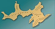
The South Shetland Islands are a group of Antarctic islands, lying about north of the Antarctic Peninsula, with a total area of . By the Antarctic Treaty of 1959, the Islands' sovereignty is neither recognized nor disputed by the signatories and they are free for use by any signatory for...
, Antarctica extending 10 km in the east-northeast direction towards Renier Point
Renier Point
Renier Point is a narrow point forming the east extremity of both Burgas Peninsula and Livingston Island in the South Shetland Islands, Antarctica. The feature was known to sealers as Point Renier as early as 1821. The name ‘Pin Point’, given by Discovery Investigations personnel on the...
and 4.7 km wide. It is bounded by Bruix Cove
Bruix Cove
Bruix Cove is the 1.93 km wide cove indenting for 1.75 km the south coast of Moon Bay in eastern Livingston Island, the South Shetland Islands in Antarctica. Entered between Yana Point and Rila Point. Most of the cove's coastline is formed by the terminus od Iskar Glacier.The feature is...
, Moon Bay
Moon Bay
Moon Bay is a 7 mi wide bay, which recedes 4 mi between Edinburgh Hill and Renier Point, on the east side of Livingston Island, in the South Shetland Islands, Antarctica. Half Moon Island is situated in the bay. Moon Bay was known to sealers in the area as early as 1821. Recharted by...
and Mugla Passage
Mugla Passage
Mugla Passage is the 1.35 km wide passage between Half Moon Island and the north coast of Burgas Peninsula on Livingston Island in the South Shetland Islands, Antarctica.The passage is named after the settlement of Mugla in southern Bulgaria....
to the north, and Bransfield Strait
Bransfield Strait
Bransfield Strait is a body of water about wide extending for in a general northeast-southwest direction between the South Shetland Islands and Antarctic Peninsula. It was named in about 1825 by James Weddell, Master, Royal Navy, for Edward Bransfield, Master, RN, who charted the South Shetland...
to the south-southeast. The peninsula's interior is occupied by the Delchev Ridge
Delchev Ridge
Delchev Ridge is the eastern ridge of the Tangra Mountains, Livingston Island and extends 10 km east-northeastward from Devin Saddle to Renier Point. The ridge is named in association with Delchev Peak.-Location:...
of Tangra Mountains
Tangra Mountains
Tangra Mountains form the principal mountain range of Livingston Island in the South Shetland Islands, Antarctica...
.
The Burgas Peninsula is named after the Bulgarian city of Burgas
Burgas
-History:During the rule of the Ancient Romans, near Burgas, Debeltum was established as a military colony for veterans by Vespasian. In the Middle Ages, a small fortress called Pyrgos was erected where Burgas is today and was most probably used as a watchtower...
.
Location
The midpoint of the peninsula is located at 62°37′40"S 59°54′00"W.British mapping in 1822 and 1968, Chilean in 1971, Argentine in 1980, Spanish mapping in 1991, and Bulgarian topographic survey Tangra 2004/05
Tangra 2004/05
The Tangra 2004/05 Expedition was commissioned by the Antarctic Place-names Commission at the Ministry of Foreign Affairs of Bulgaria, managed by the Manfred Wörner Foundation, and supported by the Bulgarian Antarctic Institute, the Institute of Mathematics and Informatics at the Bulgarian Academy...
and mapping in 2005 and 2009.
Maps
- L.L. Ivanov et al. Antarctica: Livingston Island and Greenwich Island, South Shetland Islands. Scale 1:100000 topographic map. Sofia: Antarctic Place-names Commission of Bulgaria, 2005.
- L.L. Ivanov. Antarctica: Livingston Island and Greenwich, Robert, Snow and Smith Islands. Scale 1:120000 topographic map. Troyan: Manfred Wörner Foundation, 2009. ISBN 978-954-92032-6-4