
List of rivers of the Americas by coastline
Encyclopedia
This list of rivers of the Americas by coastline includes the major river
s of the Americas
arranged according to their positions along the ocean coastlines:
Capes in the Americas
This is a counterpart to the primarily alphabetical List of rivers of the Americas although only rivers which reach the ocean are included here, not tributaries.River
A river is a natural watercourse, usually freshwater, flowing towards an ocean, a lake, a sea, or another river. In a few cases, a river simply flows into the ground or dries up completely before reaching another body of water. Small rivers may also be called by several other names, including...
s of the Americas
Americas
The Americas, or America , are lands in the Western hemisphere, also known as the New World. In English, the plural form the Americas is often used to refer to the landmasses of North America and South America with their associated islands and regions, while the singular form America is primarily...
arranged according to their positions along the ocean coastlines:
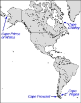
- Arctic OceanArctic OceanThe Arctic Ocean, located in the Northern Hemisphere and mostly in the Arctic north polar region, is the smallest and shallowest of the world's five major oceanic divisions...
coast (including Hudson BayHudson BayHudson Bay , sometimes called Hudson's Bay, is a large body of saltwater in northeastern Canada. It drains a very large area, about , that includes parts of Ontario, Quebec, Saskatchewan, Alberta, most of Manitoba, southeastern Nunavut, as well as parts of North Dakota, South Dakota, Minnesota,...
) from Cape Prince of WalesCape Prince of WalesCape Prince of Wales is the westernmost point on the mainland of the Americas.Located on the Seward Peninsula of the U.S. state of Alaska near the city of Wales, Cape Prince of Wales is the terminus of the Continental Divide, marking the division between the Pacific and Arctic coasts, as well as...
east to Cape ChidleyCape ChidleyCape Chidley is a headland located on the eastern shore of Killiniq Island, Canada at the northeastern tip of the Labrador Peninsula.-Cape Chidley:...
; - Atlantic OceanAtlantic OceanThe Atlantic Ocean is the second-largest of the world's oceanic divisions. With a total area of about , it covers approximately 20% of the Earth's surface and about 26% of its water surface area...
coast from Cape Chidley south to Cape Virgins; - Pacific OceanPacific OceanThe Pacific Ocean is the largest of the Earth's oceanic divisions. It extends from the Arctic in the north to the Southern Ocean in the south, bounded by Asia and Australia in the west, and the Americas in the east.At 165.2 million square kilometres in area, this largest division of the World...
coast from Cape Prince of Wales south to Cape Virgins; - Inland basinsEndorheicAn endorheic basin is a closed drainage basin that retains water and allows no outflow to other bodies of water such as rivers or oceans...
, by basin from north to south.
Capes in the Americas
Arctic Ocean coast
- MackenzieMackenzie RiverThe Mackenzie River is the largest river system in Canada. It flows through a vast, isolated region of forest and tundra entirely within the country's Northwest Territories, although its many tributaries reach into four other Canadian provinces and territories...
- Northwest TerritoriesNorthwest TerritoriesThe Northwest Territories is a federal territory of Canada.Located in northern Canada, the territory borders Canada's two other territories, Yukon to the west and Nunavut to the east, and three provinces: British Columbia to the southwest, and Alberta and Saskatchewan to the south... - Chesterfield InletChesterfield InletChesterfield Inlet is an inlet in Kivalliq Region, Nunavut, Canada. It is an arm of northwestern Hudson Bay, and the end point of the Thelon River after its passage through Baker Lake. Cross Bay, a large widening of the inlet, occurs east of Baker Lake...
- Dawson Inlet
- Maguse LakeMaguse LakeMaguse Lake is a lake in Kivalliq Region, Nunavut, Canada. It drains eastward into Hudson Bay by way of the long Maguse River. The area is frequented by caribou....
- Tha-anne River
- Thlewiaza River
- Caribou RiverCaribou River-See also:*List of rivers of Minnesota-References:**USGS Hydrologic Unit Map - State of Minnesota...
- Seal RiverSeal RiverThe Seal River is a river in the Northern Region of Manitoba, Canada. It travels from Shethanei Lake to the Hudson Bay. The river was nominated for the Canadian Heritage Rivers System in 1987 and was officially listed in 1992.-Geography:...
- North Knife River
- South Knife River
- Churchill RiverChurchill River (Hudson Bay)The Churchill River is a major river in Alberta, Saskatchewan and Manitoba, Canada. From the head of the Churchill Lake it is 1,609 km long. It was named after John Churchill, 1st Duke of Marlborough and governor of the Hudson's Bay Company from 1685 to 1691...
- Nelson RiverNelson RiverThe Nelson River is a river of north-central North America, in the Canadian province of Manitoba. Its full length is , it has mean discharge of , and has a drainage basin of , of which is in the United States...
Atlantic Ocean coast
- AmazonAmazon RiverThe Amazon of South America is the second longest river in the world and by far the largest by waterflow with an average discharge greater than the next seven largest rivers combined...
- BrazilBrazilBrazil , officially the Federative Republic of Brazil , is the largest country in South America. It is the world's fifth largest country, both by geographical area and by population with over 192 million people...
, ColombiaColombiaColombia, officially the Republic of Colombia , is a unitary constitutional republic comprising thirty-two departments. The country is located in northwestern South America, bordered to the east by Venezuela and Brazil; to the south by Ecuador and Peru; to the north by the Caribbean Sea; to the...
, PeruPeruPeru , officially the Republic of Peru , is a country in western South America. It is bordered on the north by Ecuador and Colombia, on the east by Brazil, on the southeast by Bolivia, on the south by Chile, and on the west by the Pacific Ocean.... - CaucaCauca RiverThe Cauca River is a river in Colombia that lies between the Occidental and Central cordilleras. Born in southwestern Colombia near the city of Popayán, it joins the Magdalena River near Pinillos in Bolívar Department, and the combined river eventually flows out into the Caribbean Sea. It has a...
- ColombiaColombiaColombia, officially the Republic of Colombia , is a unitary constitutional republic comprising thirty-two departments. The country is located in northwestern South America, bordered to the east by Venezuela and Brazil; to the south by Ecuador and Peru; to the north by the Caribbean Sea; to the... - HudsonHudson RiverThe Hudson is a river that flows from north to south through eastern New York. The highest official source is at Lake Tear of the Clouds, on the slopes of Mount Marcy in the Adirondack Mountains. The river itself officially begins in Henderson Lake in Newcomb, New York...
- New YorkNew YorkNew York is a state in the Northeastern region of the United States. It is the nation's third most populous state. New York is bordered by New Jersey and Pennsylvania to the south, and by Connecticut, Massachusetts and Vermont to the east... - MagdalenaMagdalena RiverThe Magdalena River is the principal river of Colombia, flowing northward about through the western half of the country. It takes its name from the biblical figure Mary Magdalene. It is navigable through much of its lower reaches, in spite of the shifting sand bars at the mouth of its delta, as...
- ColombiaColombiaColombia, officially the Republic of Colombia , is a unitary constitutional republic comprising thirty-two departments. The country is located in northwestern South America, bordered to the east by Venezuela and Brazil; to the south by Ecuador and Peru; to the north by the Caribbean Sea; to the... - MississippiMississippi RiverThe Mississippi River is the largest river system in North America. Flowing entirely in the United States, this river rises in western Minnesota and meanders slowly southwards for to the Mississippi River Delta at the Gulf of Mexico. With its many tributaries, the Mississippi's watershed drains...
- CanadaCanadaCanada is a North American country consisting of ten provinces and three territories. Located in the northern part of the continent, it extends from the Atlantic Ocean in the east to the Pacific Ocean in the west, and northward into the Arctic Ocean...
, USA - ParanáParaná RiverThe Paraná River is a river in south Central South America, running through Brazil, Paraguay and Argentina for some . It is second in length only to the Amazon River among South American rivers. The name Paraná is an abbreviation of the phrase "para rehe onáva", which comes from the Tupi language...
- ArgentinaArgentinaArgentina , officially the Argentine Republic , is the second largest country in South America by land area, after Brazil. It is constituted as a federation of 23 provinces and an autonomous city, Buenos Aires...
, BrazilBrazilBrazil , officially the Federative Republic of Brazil , is the largest country in South America. It is the world's fifth largest country, both by geographical area and by population with over 192 million people...
, ParaguayParaguayParaguay , officially the Republic of Paraguay , is a landlocked country in South America. It is bordered by Argentina to the south and southwest, Brazil to the east and northeast, and Bolivia to the northwest. Paraguay lies on both banks of the Paraguay River, which runs through the center of the... - Río Negro - ArgentinaArgentinaArgentina , officially the Argentine Republic , is the second largest country in South America by land area, after Brazil. It is constituted as a federation of 23 provinces and an autonomous city, Buenos Aires...
- Orinoco - ColombiaColombiaColombia, officially the Republic of Colombia , is a unitary constitutional republic comprising thirty-two departments. The country is located in northwestern South America, bordered to the east by Venezuela and Brazil; to the south by Ecuador and Peru; to the north by the Caribbean Sea; to the...
, VenezuelaVenezuelaVenezuela , officially called the Bolivarian Republic of Venezuela , is a tropical country on the northern coast of South America. It borders Colombia to the west, Guyana to the east, and Brazil to the south... - St. LawrenceSaint Lawrence RiverThe Saint Lawrence is a large river flowing approximately from southwest to northeast in the middle latitudes of North America, connecting the Great Lakes with the Atlantic Ocean. It is the primary drainage conveyor of the Great Lakes Basin...
- OntarioOntarioOntario is a province of Canada, located in east-central Canada. It is Canada's most populous province and second largest in total area. It is home to the nation's most populous city, Toronto, and the nation's capital, Ottawa....
, QuebecQuebecQuebec or is a province in east-central Canada. It is the only Canadian province with a predominantly French-speaking population and the only one whose sole official language is French at the provincial level.... - São FranciscoSão Francisco RiverThe São Francisco is a river in Brazil. With a length of , it is the longest river that runs entirely in Brazilian territory, and the fourth longest in South America and overall in Brazil...
- BrazilBrazilBrazil , officially the Federative Republic of Brazil , is the largest country in South America. It is the world's fifth largest country, both by geographical area and by population with over 192 million people... - UruguayUruguay RiverThe Uruguay River is a river in South America. It flows from north to south and makes boundary with Brazil, Argentina, and Uruguay, separating some of the Argentine provinces of the Mesopotamia from the other two countries...
- ArgentinaArgentinaArgentina , officially the Argentine Republic , is the second largest country in South America by land area, after Brazil. It is constituted as a federation of 23 provinces and an autonomous city, Buenos Aires...
, BrazilBrazilBrazil , officially the Federative Republic of Brazil , is the largest country in South America. It is the world's fifth largest country, both by geographical area and by population with over 192 million people...
, UruguayUruguayUruguay ,officially the Oriental Republic of Uruguay,sometimes the Eastern Republic of Uruguay; ) is a country in the southeastern part of South America. It is home to some 3.5 million people, of whom 1.8 million live in the capital Montevideo and its metropolitan area...
Pacific Ocean coast
- AconcaguaAconcagua RiverFor other uses, see Aconcagua .The Aconcagua River is a river in Chile that rises from the joint of two minor tributary rivers at above sea level in the Andes, Juncal river from the east and Blanco river from the south east...
- ChileChileChile ,officially the Republic of Chile , is a country in South America occupying a long, narrow coastal strip between the Andes mountains to the east and the Pacific Ocean to the west. It borders Peru to the north, Bolivia to the northeast, Argentina to the east, and the Drake Passage in the far... - Bío-BíoBío-Bío RiverThe Biobío River is the second largest river in Chile. It originates from Icalma and Galletué lakes in the Andes and flows 380 km to the Gulf of Arauco on the Pacific Ocean....
- ChileChileChile ,officially the Republic of Chile , is a country in South America occupying a long, narrow coastal strip between the Andes mountains to the east and the Pacific Ocean to the west. It borders Peru to the north, Bolivia to the northeast, Argentina to the east, and the Drake Passage in the far...
- MallecoMalleco RiverMalleco River is a river in Malleco Province, Araucanía Region, southern Chile. It rises in the western slopes of the Andes, within the Tolhuaca National Park and near Tolhuaca Volcano. The river is a major tributary to the Bío-Bío River. The Malleco Viaduct built in 1890 is the main landmark of...
- ChileChileChile ,officially the Republic of Chile , is a country in South America occupying a long, narrow coastal strip between the Andes mountains to the east and the Pacific Ocean to the west. It borders Peru to the north, Bolivia to the northeast, Argentina to the east, and the Drake Passage in the far...
- Malleco
- CautínCautín RiverThe Cautín is a river in Chile. It rises on the western slopes of the Cordillera de Las Raíces and flows in Araucanía Region. The river's main tributary is the Quepe River. The city of Temuco is located on the Cautín River....
- ChileChileChile ,officially the Republic of Chile , is a country in South America occupying a long, narrow coastal strip between the Andes mountains to the east and the Pacific Ocean to the west. It borders Peru to the north, Bolivia to the northeast, Argentina to the east, and the Drake Passage in the far... - Colorado
- ColumbiaColumbia RiverThe Columbia River is the largest river in the Pacific Northwest region of North America. The river rises in the Rocky Mountains of British Columbia, Canada, flows northwest and then south into the U.S. state of Washington, then turns west to form most of the border between Washington and the state...
- Washington/OregonOregonOregon is a state in the Pacific Northwest region of the United States. It is located on the Pacific coast, with Washington to the north, California to the south, Nevada on the southeast and Idaho to the east. The Columbia and Snake rivers delineate much of Oregon's northern and eastern... - ElquiElqui RiverThe Elqui River starts in the west Andes, flowing into the Pacific Ocean, crossing the Chilean city of La Serena, is a wine and pisco producing area...
- ChileChileChile ,officially the Republic of Chile , is a country in South America occupying a long, narrow coastal strip between the Andes mountains to the east and the Pacific Ocean to the west. It borders Peru to the north, Bolivia to the northeast, Argentina to the east, and the Drake Passage in the far... - ItataItata RiverThe Itata River flows in the Bío-Bío Region, southern Chile.Until the Conquest of Chile the Itata was the natural limit between the Mapuche, located to the south, and Picunche, to the north.-References:* . - External links :*...
- ChileChileChile ,officially the Republic of Chile , is a country in South America occupying a long, narrow coastal strip between the Andes mountains to the east and the Pacific Ocean to the west. It borders Peru to the north, Bolivia to the northeast, Argentina to the east, and the Drake Passage in the far...
- ÑubleÑuble RiverThe Ñuble River or Rio Ñuble is a river of the province of Ñuble, located in southern Chile in the Biobío Region. Its main tributaries are Chillán and Claro River. The Ñuble River discharges into the Itata River.- External links :*...
- ChileChileChile ,officially the Republic of Chile , is a country in South America occupying a long, narrow coastal strip between the Andes mountains to the east and the Pacific Ocean to the west. It borders Peru to the north, Bolivia to the northeast, Argentina to the east, and the Drake Passage in the far...
- Ñuble
- LoaLoa RiverThe Loa River is a U-shaped river in Chile's northern Antofagasta Region. At 440 km long it is the country's longest river and the main watercourse in the Atacama Desert.-Course:...
- ChileChileChile ,officially the Republic of Chile , is a country in South America occupying a long, narrow coastal strip between the Andes mountains to the east and the Pacific Ocean to the west. It borders Peru to the north, Bolivia to the northeast, Argentina to the east, and the Drake Passage in the far... - MaipoMaipo RiverMaipo River is the main river flowing through Santiago Metropolitan Region, Chile. Its headwaters are on the west slope of Maipo volcano, in the Andes. Its most famous tributary is Mapocho River. The Maipo River is by far the major source of irrigation and potable water for the region.-Course:In...
- ChileChileChile ,officially the Republic of Chile , is a country in South America occupying a long, narrow coastal strip between the Andes mountains to the east and the Pacific Ocean to the west. It borders Peru to the north, Bolivia to the northeast, Argentina to the east, and the Drake Passage in the far...
- MapochoMapocho RiverThe Mapocho River flows from the Andes mountains onto the west and divides Chile's capital Santiago in two.-Course:...
- ChileChileChile ,officially the Republic of Chile , is a country in South America occupying a long, narrow coastal strip between the Andes mountains to the east and the Pacific Ocean to the west. It borders Peru to the north, Bolivia to the northeast, Argentina to the east, and the Drake Passage in the far...
- Mapocho
- MauleMaule riverThe Maule river is one of the most important rivers of Chile and is inextricably linked to this country's pre-Hispanic times, the country's conquest, colonial period, wars of Independence, modern history, agriculture , culture , religion, economy and politics...
- ChileChileChile ,officially the Republic of Chile , is a country in South America occupying a long, narrow coastal strip between the Andes mountains to the east and the Pacific Ocean to the west. It borders Peru to the north, Bolivia to the northeast, Argentina to the east, and the Drake Passage in the far... - MaullínMaullín RiverMaullín River is a river of Chile located in the Los Lagos Region. The river originates as the outflow of Llanquihue Lake, and flows generally southwestward, over a number of small waterfalls, emptying into the Gulf of Coronados...
- ChileChileChile ,officially the Republic of Chile , is a country in South America occupying a long, narrow coastal strip between the Andes mountains to the east and the Pacific Ocean to the west. It borders Peru to the north, Bolivia to the northeast, Argentina to the east, and the Drake Passage in the far... - PalenaPalena RiverThe Palena River is a river of Chile. Its sources are close to the border with Argentina and it flows into the Pacific Ocean. It has a length of 6 km.-External links / References:**...
- ChileChileChile ,officially the Republic of Chile , is a country in South America occupying a long, narrow coastal strip between the Andes mountains to the east and the Pacific Ocean to the west. It borders Peru to the north, Bolivia to the northeast, Argentina to the east, and the Drake Passage in the far... - PetrohuéPetrohué RiverPetrohué River is a Chilean river located in the Los Lagos Region of Chile. It originates from Todos los Santos Lake in the Vicente Pérez Rosales National Park...
- ChileChileChile ,officially the Republic of Chile , is a country in South America occupying a long, narrow coastal strip between the Andes mountains to the east and the Pacific Ocean to the west. It borders Peru to the north, Bolivia to the northeast, Argentina to the east, and the Drake Passage in the far... - PueloPuelo RiverThe Puelo River has its origin in a lake of the same name in Argentine territory, and flows north-west throughthe Andes into the Reloncaví Estuary of the Reloncaví Sound at the northern end of the Gulf of Ancud. Its lower course is impeded in such a manner as to form the Lake Tagua Tagua...
- ChileChileChile ,officially the Republic of Chile , is a country in South America occupying a long, narrow coastal strip between the Andes mountains to the east and the Pacific Ocean to the west. It borders Peru to the north, Bolivia to the northeast, Argentina to the east, and the Drake Passage in the far... - RahueRahue RiverRahue River is a river of Chile located in Los Lagos Region. It rises at the western end of the Rupanco Lake. In its middle course, the river flows through the city of Osorno in a north-south direction. Rahue river empties into the Bueno River 40 km inland from the Pacific Ocean.-References:...
- ChileChileChile ,officially the Republic of Chile , is a country in South America occupying a long, narrow coastal strip between the Andes mountains to the east and the Pacific Ocean to the west. It borders Peru to the north, Bolivia to the northeast, Argentina to the east, and the Drake Passage in the far... - RapelRapel RiverRapel River is a river of Chile located in the O'Higgins Region. It begins at the confluence of the rivers Cachapoal and Tinguiririca in the area known as La Junta...
- ChileChileChile ,officially the Republic of Chile , is a country in South America occupying a long, narrow coastal strip between the Andes mountains to the east and the Pacific Ocean to the west. It borders Peru to the north, Bolivia to the northeast, Argentina to the east, and the Drake Passage in the far... - ReñihueReñihue RiverThe Reñihue River is a river in the Palena Province of the Los Lagos Region in Chile.-Pumalín Park:The river flows through Pumalín Park, a privately owned and publicly accessible nature reserve owned by The Conservation Land Trust...
- ChileChileChile ,officially the Republic of Chile , is a country in South America occupying a long, narrow coastal strip between the Andes mountains to the east and the Pacific Ocean to the west. It borders Peru to the north, Bolivia to the northeast, Argentina to the east, and the Drake Passage in the far... - Río Bueno - ChileChileChile ,officially the Republic of Chile , is a country in South America occupying a long, narrow coastal strip between the Andes mountains to the east and the Pacific Ocean to the west. It borders Peru to the north, Bolivia to the northeast, Argentina to the east, and the Drake Passage in the far...
- SacramentoSacramento RiverThe Sacramento River is an important watercourse of Northern and Central California in the United States. The largest river in California, it rises on the eastern slopes of the Klamath Mountains, and after a journey south of over , empties into Suisun Bay, an arm of the San Francisco Bay, and...
- CaliforniaCaliforniaCalifornia is a state located on the West Coast of the United States. It is by far the most populous U.S. state, and the third-largest by land area... - San JoaquinSan Joaquin RiverThe San Joaquin River is the largest river of Central California in the United States. At over long, the river starts in the high Sierra Nevada, and flows through a rich agricultural region known as the San Joaquin Valley before reaching Suisun Bay, San Francisco Bay, and the Pacific Ocean...
- CaliforniaCaliforniaCalifornia is a state located on the West Coast of the United States. It is by far the most populous U.S. state, and the third-largest by land area... - TolténToltén RiverToltén River is a river located in the Araucanía Region of Chile. It rises at Villarrica Lake, close to the city of the same name. Its major tributary is Allipén River...
- ChileChileChile ,officially the Republic of Chile , is a country in South America occupying a long, narrow coastal strip between the Andes mountains to the east and the Pacific Ocean to the west. It borders Peru to the north, Bolivia to the northeast, Argentina to the east, and the Drake Passage in the far...
- TrancuraTrancura RiverTrancura River is a river located in the Araucanía Region of Chile. Its headwaters drain the southeasternmost portion of Villarrica National Park, including the northwestern slope of Lanín volcano...
- ChileChileChile ,officially the Republic of Chile , is a country in South America occupying a long, narrow coastal strip between the Andes mountains to the east and the Pacific Ocean to the west. It borders Peru to the north, Bolivia to the northeast, Argentina to the east, and the Drake Passage in the far...
- Trancura
- ValdiviaValdivia RiverThe Valdivia River or Río Valdivia, as it is known locally, is a major river in southern Chile. It is the continuation of the Calle-Calle River, from the point where it meets the Cau-Cau River in the city of Valdivia. The Valdivia river ends in Corral Bay, on the Pacific coast. Other tributaries...
- ChileChileChile ,officially the Republic of Chile , is a country in South America occupying a long, narrow coastal strip between the Andes mountains to the east and the Pacific Ocean to the west. It borders Peru to the north, Bolivia to the northeast, Argentina to the east, and the Drake Passage in the far...
- Calle-CalleCalle-Calle RiverCalle-Calle River also called Gudalafquén in Mapudungun, is a river in Valdivia Province, southern Chile. It drains waters from the San Pedro River to the Valdivia River, which in turn flows into Corral Bay on the Pacific Ocean.The Calle-Calle is the only river in Chile that is considered...
- ChileChileChile ,officially the Republic of Chile , is a country in South America occupying a long, narrow coastal strip between the Andes mountains to the east and the Pacific Ocean to the west. It borders Peru to the north, Bolivia to the northeast, Argentina to the east, and the Drake Passage in the far...
- San Pedro - ChileChileChile ,officially the Republic of Chile , is a country in South America occupying a long, narrow coastal strip between the Andes mountains to the east and the Pacific Ocean to the west. It borders Peru to the north, Bolivia to the northeast, Argentina to the east, and the Drake Passage in the far...
- EncoEnco RiverEnco River is a river in Panguipulli commune in southern Chile. By flowing from Panguipulli Lake to Riñihue Lake Enco River carries the water of the six upper lakes of the Seven Lakes area into Riñihue, the last lake in the chain...
- ChileChileChile ,officially the Republic of Chile , is a country in South America occupying a long, narrow coastal strip between the Andes mountains to the east and the Pacific Ocean to the west. It borders Peru to the north, Bolivia to the northeast, Argentina to the east, and the Drake Passage in the far...
- LlanquihueLlanquihue RiverLlanquihue River is a river in the commune of Panguipulli, southern Chile. It is formed by the union of Neltume River and Fui River. Llanquihue River flows in a south and westward and outflows in Panguipulli Lake....
- ChileChileChile ,officially the Republic of Chile , is a country in South America occupying a long, narrow coastal strip between the Andes mountains to the east and the Pacific Ocean to the west. It borders Peru to the north, Bolivia to the northeast, Argentina to the east, and the Drake Passage in the far...
- HuahumHuahum RiverThe Huahum River or Río Huahum, as it is known locally, is a river in southern Chile and Argentina. It drains the waters of Lácar Lake in Argentina to Pirihueico Lake in Chile. The river gives name to Huahum Pass, an international mountain pass on the border between Chile and Argentina....
- ChileChileChile ,officially the Republic of Chile , is a country in South America occupying a long, narrow coastal strip between the Andes mountains to the east and the Pacific Ocean to the west. It borders Peru to the north, Bolivia to the northeast, Argentina to the east, and the Drake Passage in the far...
, ArgentinaArgentinaArgentina , officially the Argentine Republic , is the second largest country in South America by land area, after Brazil. It is constituted as a federation of 23 provinces and an autonomous city, Buenos Aires...
- LiquiñeLiquiñe RiverThe Liquiñe River is a in the Andes of Los Ríos Region, Chile. The river is most known for the many hotsprings the upwell at its middle reaches where the town of Liquiñe is currently placed.-References:*...
- ChileChileChile ,officially the Republic of Chile , is a country in South America occupying a long, narrow coastal strip between the Andes mountains to the east and the Pacific Ocean to the west. It borders Peru to the north, Bolivia to the northeast, Argentina to the east, and the Drake Passage in the far...
- Huahum
- Llanquihue
- Enco
- San Pedro - Chile
- Cau-CauCau-Cau RiverCau-Cau River is minor river in the city of Valdivia, southern Chile. Cau-Cau River acts as a regulating channel between Cruces River and Calle-Calle River forming the Isla Teja island in front of the city centre. It confluence with Calle-Calle River marks the beginning of Valdivia River....
- ChileChileChile ,officially the Republic of Chile , is a country in South America occupying a long, narrow coastal strip between the Andes mountains to the east and the Pacific Ocean to the west. It borders Peru to the north, Bolivia to the northeast, Argentina to the east, and the Drake Passage in the far... - CrucesCruces RiverThe Cruces River is a river near Valdivia, Chile. Río Cruces originates from hills near the Villarica volcano and flows then in south-west direction. The southern and final part of the river follows the Valdivian Coastal Range. At the latitude of Valdivia it is crossed by Río Cruces Bridge near...
- ChileChileChile ,officially the Republic of Chile , is a country in South America occupying a long, narrow coastal strip between the Andes mountains to the east and the Pacific Ocean to the west. It borders Peru to the north, Bolivia to the northeast, Argentina to the east, and the Drake Passage in the far... - CutipayCutipay RiverCutipay River is a river in Valdivia municipality, southern Chile. Cutipay is often referred as an inlet of Valdivia River rather than a river. The water flow in Cutapay changes twice a day due the tide that affects Valdivia River....
- ChileChileChile ,officially the Republic of Chile , is a country in South America occupying a long, narrow coastal strip between the Andes mountains to the east and the Pacific Ocean to the west. It borders Peru to the north, Bolivia to the northeast, Argentina to the east, and the Drake Passage in the far... - FutaFuta RiverFuta River is a river in Los Ríos Region, Chile. It drains waters from the cordillera at the Valdivian Coast Range border north to Tornagaleones River, which in turn flows into the Pacific Ocean at Corral Bay....
- ChileChileChile ,officially the Republic of Chile , is a country in South America occupying a long, narrow coastal strip between the Andes mountains to the east and the Pacific Ocean to the west. It borders Peru to the north, Bolivia to the northeast, Argentina to the east, and the Drake Passage in the far...
- Calle-Calle
- YelchoYelcho River-References:*...
- ChileChileChile ,officially the Republic of Chile , is a country in South America occupying a long, narrow coastal strip between the Andes mountains to the east and the Pacific Ocean to the west. It borders Peru to the north, Bolivia to the northeast, Argentina to the east, and the Drake Passage in the far...
- FutaleufúFutaleufú RiverThe Futaleufú River is a river fed by the lakes in the Los Alerces National Park in Chubut Province, Argentina, crossing the Andes Mountains and the international border into Chile and opening into the Yelcho Lake....
- ChileChileChile ,officially the Republic of Chile , is a country in South America occupying a long, narrow coastal strip between the Andes mountains to the east and the Pacific Ocean to the west. It borders Peru to the north, Bolivia to the northeast, Argentina to the east, and the Drake Passage in the far...
- Futaleufú
Inland basins
- Carson SinkCarson SinkCarson Sink is a playa in the northeastern portion of the Carson Desert that was formerly the terminus of the Carson River. The sink is currently fed by drainage canals of the Truckee-Carson Irrigation District...
, NevadaNevadaNevada is a state in the western, mountain west, and southwestern regions of the United States. With an area of and a population of about 2.7 million, it is the 7th-largest and 35th-most populous state. Over two-thirds of Nevada's people live in the Las Vegas metropolitan area, which contains its...
- Carson RiverCarson RiverThe Carson River is a northwestern Nevada river that empties into the Carson Sink, an endorheic basin. The main stem of the river is long....
- Carson River
- Humboldt SinkHumboldt SinkHumboldt Sink is an intermittent dry lake bed, approximately 11 mi long, and 4 mi across, in northwestern Nevada in the United States...
, NevadaNevadaNevada is a state in the western, mountain west, and southwestern regions of the United States. With an area of and a population of about 2.7 million, it is the 7th-largest and 35th-most populous state. Over two-thirds of Nevada's people live in the Las Vegas metropolitan area, which contains its...
- Humboldt RiverHumboldt RiverThe Humboldt River runs through northern Nevada in the western United States. At approximately long it is the second longest river in the Great Basin, after the Bear River. It has no outlet to the ocean, but instead empties into the Humboldt Sink...
- Humboldt River
- Pyramid LakePyramid LakePyramid Lake is the geographic sink of the Truckee River Basin and is located northeast of Reno. The inflow is moderately high silt-loaded surface runoff....
, NevadaNevadaNevada is a state in the western, mountain west, and southwestern regions of the United States. With an area of and a population of about 2.7 million, it is the 7th-largest and 35th-most populous state. Over two-thirds of Nevada's people live in the Las Vegas metropolitan area, which contains its...
- Truckee RiverTruckee RiverThe Truckee River is a stream in the U.S. states of California and Nevada. The river is about long. Its endorheic drainage basin is about , of which about are in Nevada. The Truckee is the sole outlet of Lake Tahoe and drains part of the high Sierra Nevada, emptying into Pyramid Lake in the Great...
- Truckee River
- Salton SeaSalton SeaThe Salton Sea is a shallow, saline, endorheic rift lake located directly on the San Andreas Fault, predominantly in California's Imperial Valley. The lake occupies the lowest elevations of the Salton Sink in the Colorado Desert of Imperial and Riverside counties in Southern California. Like Death...
, CaliforniaCaliforniaCalifornia is a state located on the West Coast of the United States. It is by far the most populous U.S. state, and the third-largest by land area...
- New River
- Alamo River
- Alamo River
- Walker LakeWalker Lake (Nevada)Walker Lake is a natural lake, 50.3 mi² in area, in the Great Basin in western Nevada in the United States. It is 18 mi long and 7 mi wide, located in northwestern Mineral County along the eastern side of the Wassuk Range, approximately 75 mi southeast of Reno...
, NevadaNevadaNevada is a state in the western, mountain west, and southwestern regions of the United States. With an area of and a population of about 2.7 million, it is the 7th-largest and 35th-most populous state. Over two-thirds of Nevada's people live in the Las Vegas metropolitan area, which contains its...
- Walker River