
Cruces River
Encyclopedia
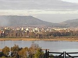
The Cruces River is a river near Valdivia
, Chile
. Río Cruces originates from hills near the Villarica volcano
and flows then in south-west direction. The southern and final part of the river follows the Valdivian Coastal Range
. At the latitude of Valdivia it is crossed by Río Cruces Bridge
near its outflow into Valdivia River. The small village of Punucapa
is the main centre for tourism in Río Cruces. The river flow through (or near) the cities of Loncoche, Lanco, and Mariquina. Some of the wetlands in the river's lower flow are inside Carlos Anwandter Nature Sanctuary
, a protected area that in the river that extends roughly from Punucapa in the south to San Luis de Alba Fort
in the north.
due to the Arauco War
, its main land route (Camino Real
in Spanish) to Concepción
was drawn following the Cruces river. The river is home to thousands of birds that live in its wetlands. The wetlands were created when the soil that surrounded the river sunk during the Great Chilean Earthquake
. The wetlands The most known bird of the place is the Black-necked Swan
. In 2004 a CELCO
pulp mill
opened near San José de la Mariquina, and begun to contaminate the wetlands of the river.
Valdivia, Chile
Valdivia is a city and commune in southern Chile administered by the Municipality of Valdivia. The city is named after its founder Pedro de Valdivia and is located at the confluence of the Calle-Calle, Valdivia and Cau-Cau Rivers, approximately east of the coastal towns of Corral and Niebla...
, Chile
Chile
Chile ,officially the Republic of Chile , is a country in South America occupying a long, narrow coastal strip between the Andes mountains to the east and the Pacific Ocean to the west. It borders Peru to the north, Bolivia to the northeast, Argentina to the east, and the Drake Passage in the far...
. Río Cruces originates from hills near the Villarica volcano
Villarrica (volcano)
Villarrica is one of Chile's most active volcanoes, rising above the lake and town of the same name. The volcano is also known as Rucapillán, a Mapuche word meaning "House of the Pillán". It is the westernmost of three large stratovolcanoes that trend perpendicular to the Andean chain along the...
and flows then in south-west direction. The southern and final part of the river follows the Valdivian Coastal Range
Valdivian Coastal Range
The Valdivian Coastal Range is a mountain range in southern Chile, along the Pacific coast. Named for the city of Valdivia, it covers about 1 million acres of the Valdivian temperate rain forests, approximately one-quarter of which are protected. It forms part of the larger Chilean Coast Range...
. At the latitude of Valdivia it is crossed by Río Cruces Bridge
Río Cruces Bridge
Río Cruces Bridge is a triangular bridge spanning Cruces River that unites Isla Teja from Torobayo, a sub-urban area of Valdivia. Together with Pedro de Valdivia Bridge it allows connection from Valdivia to the coastal town Niebla. Before the opening of Río Cruces Bridge the main access to Niebla...
near its outflow into Valdivia River. The small village of Punucapa
Punucapa
Punucapa is a hamlet of pre-Hispanic origin in Los Ríos Region, Chile. Its isolated location by the Cruces River and the Valdivian Coastal Range has make the village an ecotourism attraction. The wetlands of the river is the home to thousands of birds; the Black-necked Swan is the most emblematic...
is the main centre for tourism in Río Cruces. The river flow through (or near) the cities of Loncoche, Lanco, and Mariquina. Some of the wetlands in the river's lower flow are inside Carlos Anwandter Nature Sanctuary
Carlos Anwandter Nature Sanctuary
Carlos Anwandter Nature Sanctuary is protected wetland in Cruces River about north of Valdivia, Chile. The sanctuary is named after the German politician Carlos Anwandter who settled in Valdivia during the 1850s...
, a protected area that in the river that extends roughly from Punucapa in the south to San Luis de Alba Fort
Valdivian Fort System
The Fort System of Valdivia are a series of Spanish colonial fortifications at Corral Bay, Valdivia and Cruces River established to protect the city of Valdivia, in southern Chile. During the period of Spanish rule , it was one of the biggest systems of fortification in the Americas. It was also a...
in the north.
History
Since pre-Hispanic times the river has been used by the Indians to transport food for commerce. In its early days the city of Valdivia received vegetables from villages via the Cruces River. Before Valdivia became isolated from the rest of the Spanish EmpireSpanish Empire
The Spanish Empire comprised territories and colonies administered directly by Spain in Europe, in America, Africa, Asia and Oceania. It originated during the Age of Exploration and was therefore one of the first global empires. At the time of Habsburgs, Spain reached the peak of its world power....
due to the Arauco War
Arauco War
The Arauco War was a conflict between colonial Spaniards and the Mapuche people in what is now the Araucanía and Biobío regions of modern Chile...
, its main land route (Camino Real
Inca road system
The Inca road system was the most extensive and advanced transportation system in pre-Columbian South America. The network was based on two north-south roads with numerous branches. The best known portion of the road system is the Inca Trail to Machu Picchu...
in Spanish) to Concepción
Concepción, Chile
Concepción is a city in Chile, capital of Concepción Province and of the Biobío Region or Region VIII. Greater Concepción is the second-largest conurbation in the country, with 889,725 inhabitants...
was drawn following the Cruces river. The river is home to thousands of birds that live in its wetlands. The wetlands were created when the soil that surrounded the river sunk during the Great Chilean Earthquake
Great Chilean Earthquake
The 1960 Valdivia earthquake or Great Chilean Earthquake of Sunday, 22 May 1960 is to date the most powerful earthquake ever recorded on Earth, rating 9.5 on the moment magnitude scale...
. The wetlands The most known bird of the place is the Black-necked Swan
Black-necked Swan
The Black-necked Swan is the largest waterfowl native to South America. Males are and weigh 4.5-6.7 kg ; females are and weigh 3.5-4.4 kg . The wingspan ranges from . The body plumage is white with a black neck, head and greyish bill. It has a red knob near the base of the bill and...
. In 2004 a CELCO
Celco
Celco is a CRT film recorder manufacturing company. The company has developed xCRT advanced imaging technology that every Celco's recorders are using....
pulp mill
Pulp mill
A pulp mill is a manufacturing facility that converts wood chips or other plant fibre source into a thick fibre board which can be shipped to a paper mill for further processing. Pulp can be manufactured using mechanical, semi-chemical or fully chemical methods...
opened near San José de la Mariquina, and begun to contaminate the wetlands of the river.