

Cape Chidley
Encyclopedia
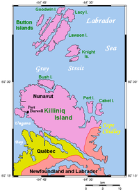
Cape Chidley is a headland
located on the eastern shore of Killiniq Island
, Canada
at the northeastern tip of the Labrador Peninsula
.
On October 22, 1943, the German ship U-537 landed just south of Cape Chidley and set up Weather Station Kurt
to collect data about the weather.
Originally, Cape Chidley was meant to be the site for a long range radar station called "N-30." It was to fall within plans for the Pinetree Line
, a series of radar stations across the 50th parallel. Supplies were moved to the site by ship during 1951-52, but late 1952-early 1953 the site was moved to Resolution Island.
and the territory of Nunavut
. It forms the northernmost point of Labrador
.
Sometimes spelled Cape Chudleigh, Cape Chidley is sometimes misrepresented as being located on the interprovincial border between Quebec
and Newfoundland and Labrador. Newfoundland
, having been a separate country at the time that Canada's Arctic islands were assigned in this manner, shared a boundary on Killiniq Island as the territory of Labrador included the entire Atlantic watershed of the Labrador Peninsula and its islands.
 As such, the northern and western part of Killiniq Island under Nunavut's jurisdiction drains into Ungava Bay
and the Hudson Strait
. Thus Cape Chidley is also the terminus of the Northern Divide, which separates the Arctic Ocean
watershed
from the Atlantic Ocean
watershed. (Some sources include Hudson Bay
in the Atlantic Ocean watershed, though the Northern Divide has been long established and places Hudson Bay with the Arctic Ocean watershed.) The cape marks the south end of the entrance to the Hudson Strait
, opposite Resolution Island
.
The closest community to Cape Chidley is Port Burwell, Nunavut. Killiniq Island itself is separated from mainland North America by the narrow McLelan Strait.
The Torngat Mountains
run along the coast of Labrador and terminate at Killiniq Island. The top of the knoll forming the headland at Cape Chidley has an elevation of 350 m (1,148.3 ft) making the cape considerably higher than either of its two flanking headlands.
The Cape Chidley Islands
lie at the north end of the cape.
Headlands and bays
Headlands and bays are two related features of the coastal environment.- Geology and geography :Headlands and bays are often found on the same coastline. A bay is surrounded by land on three sides, whereas a headland is surrounded by water on three sides. Headlands are characterized by high,...
located on the eastern shore of Killiniq Island
Killiniq Island
Killiniq Island is a small, remote island in northeastern Canada. Located at the extreme northern tip of Labrador between Ungava Bay and the Labrador Sea, it is notable in that it contains the only land border between Nunavut territory and the province of Newfoundland and Labrador...
, Canada
Canada
Canada is a North American country consisting of ten provinces and three territories. Located in the northern part of the continent, it extends from the Atlantic Ocean in the east to the Pacific Ocean in the west, and northward into the Arctic Ocean...
at the northeastern tip of the Labrador Peninsula
Labrador Peninsula
The Labrador Peninsula is a large peninsula in eastern Canada. It is bounded by the Hudson Bay to the west, the Hudson Strait to the north, the Labrador Sea to the east, and the Gulf of Saint Lawrence to the south-east...
.
Cape Chidley
Cape Chidley was named by English explorer John Davis on August 1, 1587 after his friend and fellow explorer John Chidley.On October 22, 1943, the German ship U-537 landed just south of Cape Chidley and set up Weather Station Kurt
Weather Station Kurt
Weather Station Kurt was an Automatic weather station, erected by a German U-boat crew in Northern Labrador, Newfoundland in October 1943. This was the only armed German military operation on land in North America during the Second World War.-Background:Weather in the Northern Hemisphere...
to collect data about the weather.
Originally, Cape Chidley was meant to be the site for a long range radar station called "N-30." It was to fall within plans for the Pinetree Line
Pinetree Line
The Pinetree Line was a series of radar stations located across the northern United States and southern Canada at about the 50th parallel north, along with a number of other stations located on the Atlantic and Pacific coasts. Run by NORAD , over half were manned by United States Air Force...
, a series of radar stations across the 50th parallel. Supplies were moved to the site by ship during 1951-52, but late 1952-early 1953 the site was moved to Resolution Island.
Location
Cape Chidley is located on the interprovincial boundary between the province of Newfoundland and LabradorNewfoundland and Labrador
Newfoundland and Labrador is the easternmost province of Canada. Situated in the country's Atlantic region, it incorporates the island of Newfoundland and mainland Labrador with a combined area of . As of April 2011, the province's estimated population is 508,400...
and the territory of Nunavut
Nunavut
Nunavut is the largest and newest federal territory of Canada; it was separated officially from the Northwest Territories on April 1, 1999, via the Nunavut Act and the Nunavut Land Claims Agreement Act, though the actual boundaries had been established in 1993...
. It forms the northernmost point of Labrador
Labrador
Labrador is the distinct, northerly region of the Canadian province of Newfoundland and Labrador. It comprises the mainland portion of the province, separated from the island of Newfoundland by the Strait of Belle Isle...
.
Sometimes spelled Cape Chudleigh, Cape Chidley is sometimes misrepresented as being located on the interprovincial border between Quebec
Quebec
Quebec or is a province in east-central Canada. It is the only Canadian province with a predominantly French-speaking population and the only one whose sole official language is French at the provincial level....
and Newfoundland and Labrador. Newfoundland
Dominion of Newfoundland
The Dominion of Newfoundland was a British Dominion from 1907 to 1949 . The Dominion of Newfoundland was situated in northeastern North America along the Atlantic coast and comprised the island of Newfoundland and Labrador on the continental mainland...
, having been a separate country at the time that Canada's Arctic islands were assigned in this manner, shared a boundary on Killiniq Island as the territory of Labrador included the entire Atlantic watershed of the Labrador Peninsula and its islands.
Ungava Bay
Ungava Bay is a large bay in northeastern Canada separating Nunavik from Baffin Island. The bay is shaped like a rounded square with a side length of about and has an area of approximately...
and the Hudson Strait
Hudson Strait
Hudson Strait links the Atlantic Ocean to Hudson Bay in Canada. It lies between Baffin Island and the northern coast of Quebec, its eastern entrance marked by Cape Chidley and Resolution Island. It is long...
. Thus Cape Chidley is also the terminus of the Northern Divide, which separates the Arctic Ocean
Arctic Ocean
The Arctic Ocean, located in the Northern Hemisphere and mostly in the Arctic north polar region, is the smallest and shallowest of the world's five major oceanic divisions...
watershed
Drainage basin
A drainage basin is an extent or an area of land where surface water from rain and melting snow or ice converges to a single point, usually the exit of the basin, where the waters join another waterbody, such as a river, lake, reservoir, estuary, wetland, sea, or ocean...
from the Atlantic Ocean
Atlantic Ocean
The Atlantic Ocean is the second-largest of the world's oceanic divisions. With a total area of about , it covers approximately 20% of the Earth's surface and about 26% of its water surface area...
watershed. (Some sources include Hudson Bay
Hudson Bay
Hudson Bay , sometimes called Hudson's Bay, is a large body of saltwater in northeastern Canada. It drains a very large area, about , that includes parts of Ontario, Quebec, Saskatchewan, Alberta, most of Manitoba, southeastern Nunavut, as well as parts of North Dakota, South Dakota, Minnesota,...
in the Atlantic Ocean watershed, though the Northern Divide has been long established and places Hudson Bay with the Arctic Ocean watershed.) The cape marks the south end of the entrance to the Hudson Strait
Hudson Strait
Hudson Strait links the Atlantic Ocean to Hudson Bay in Canada. It lies between Baffin Island and the northern coast of Quebec, its eastern entrance marked by Cape Chidley and Resolution Island. It is long...
, opposite Resolution Island
Resolution Island (Nunavut)
Resolution Island is one of the many uninhabited Canadian Arctic islands in Qikiqtaaluk Region, Nunavut. It is a Baffin Island offshore island located in Hudson Strait. It has an area of...
.
The closest community to Cape Chidley is Port Burwell, Nunavut. Killiniq Island itself is separated from mainland North America by the narrow McLelan Strait.
The Torngat Mountains
Torngat Mountains
The Torngat Mountains are a mountain range on the Labrador Peninsula at the northern tip of Newfoundland and Labrador and eastern Quebec. They are part of the Arctic Cordillera. This is the peninsula that separates Ungava Bay from the Atlantic Ocean....
run along the coast of Labrador and terminate at Killiniq Island. The top of the knoll forming the headland at Cape Chidley has an elevation of 350 m (1,148.3 ft) making the cape considerably higher than either of its two flanking headlands.
The Cape Chidley Islands
Cape Chidley Islands
The Cape Chidley Islands are members of the Canadian Arctic Archipelago in the territory of Nunavut. They are located in the Labrador Sea at the south end of the entrance to the Hudson Strait, north of Killiniq Island's Cape Chidley, and separated from Killiniq Island by the MacGregor Strait.Cabot...
lie at the north end of the cape.