

List of World Heritage Sites in the Arab States
Encyclopedia
This is a list of the UNESCO World Heritage Sites in the Arab States. Some of these countries are geographically located in Asia and some in Africa.
s and acre
s, excluding any buffer zones, with a value of zero implying that no data is published by UNESCO; the year the site was inscribed; and a description of the site.
List
The list below contains an image of the site or part of the site; the name as inscribed by UNESCO; the location; the nominating state party; the criteria met by the site, including if it is a cultural, natural or mixed; the area in hectareHectare
The hectare is a metric unit of area defined as 10,000 square metres , and primarily used in the measurement of land. In 1795, when the metric system was introduced, the are was defined as being 100 square metres and the hectare was thus 100 ares or 1/100 km2...
s and acre
Acre
The acre is a unit of area in a number of different systems, including the imperial and U.S. customary systems. The most commonly used acres today are the international acre and, in the United States, the survey acre. The most common use of the acre is to measure tracts of land.The acre is related...
s, excluding any buffer zones, with a value of zero implying that no data is published by UNESCO; the year the site was inscribed; and a description of the site.
| Image | | Site | | Location | | Criteria | | Area (ha) | | Area (acre) | | Year | | Description |
|---|---|---|---|---|---|---|---|
| Al Qal'a of Beni Hammad | M'Sila Province M'Sila Province M'Sila is a province of northern Algeria. It has a population of 1 million people and an area of 18,718 km², while its capital, also called M'sila, home to M'Sila University, has a population of about 100,000. Some localities in this wilaya are Bou Saada and Maadid. Chott El Hodna, a salt... ,  Algeria Algeria |
Cultural: (iii) |
150 hectares (370.7 acre) | 1980 | In a mountainous site of extraordinary beauty, the ruins of the first capital of the Hammadid emirs, founded in 1007 and demolished in 1152, provide an authentic picture of a fortified Muslim city. | ||
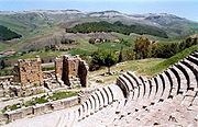 |
Djémila Djemila Djémila is a mountain village in Algeria, near the northern coast east of Algiers, where some of the best preserved Berbero-Roman ruins in North Africa are found... |
Sétif Province Sétif Province Sétif Province is a province in north-eastern Algeria. Its capital and largest city is Sétif, the next largest city is El Eulma. There is also the World Heritage Site of Djémila there.-Administrative divisions:... , Algeria |
Cultural: (iii)(iv) |
31 hectares (76.6 acre) | 1982 | Situated 900 m above sea-level, Djémila, or Cuicul, with its forum, temples, basilicas, triumphal arches and houses, is an interesting example of Roman town planning adapted to a mountain location. | |
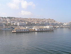 |
Kasbah of Algiers Casbah The Casbah ) is specifically the citadel of Algiers in Algeria and the traditional quarter clustered around it. More generally, a kasbah is the walled citadel of many North African cities and towns... |
Algiers Province, Algeria |
Cultural: (ii)(v) |
50 hectares (123.6 acre) | 1982 | The Kasbah is a unique kind of medina, or Islamic city. It stands in one of the finest coastal sites on the Mediterranean, overlooking the islands where a Carthaginian trading-post was established in the 4th century BC. | |
 |
M'zab Valley M'zab The M'zab or Mzab, , is a region of the northern Sahara, in the Ghardaïa wilaya, an administrative division similar to a province, of Algeria... |
Ghardaïa Province Ghardaïa Province Ghardaïa is a province in eastern Algeria, named after its capital Ghardaïa. The M'Zab Valley, located there, is a UNESCO World Heritage Site.-Administrative divisions:... , Algeria |
Cultural: (ii)(iii)(v) |
4000 hectares (9,884.2 acre) | 1982 | A traditional human habitat, created in the 10th century by the Ibadites around their five ksour (fortified cities), has been preserved intact in the M’Zab valley. | |
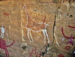
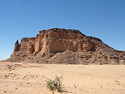
| Tassili n'Ajjer Tassili n'Ajjer Tassili n'Ajjer is a mountain range in the Algerian section of the Sahara Desert. It is a vast plateau in south-east Algeria at the borders of Libya, Niger and Mali, covering an area of 72,000 sq... |
Illizi Province Illizi Province Illizi is a province in the south-eastern corner of Algeria named after its eponymous seat.It borders Libya to the east, Ouargla Province to the north and, Tamanghasset Province to the east and south.-Administrative divisions:... and Tamanrasset Province Tamanrasset Province Tamanrasset or Tamanghasset is the largest province in Algeria. It was named after its province seat: Tamanrasset. The Province has two national parks, more than any other in Algeria. They are: Tassili n'Ajjer National Park and Ahaggar National Park... , Algeria |
Mixed: (i)(iii)(vii)(viii) |
7200000 hectares (17,791,571.7 acre) | 1982 | This site has one of the most important groupings of prehistoric cave art in the world. More than 15,000 drawings and engravings record the climatic changes, the animal migrations and the evolution of human life on the edge of the Sahara from 6000 BC to the first centuries of the present era. | ||
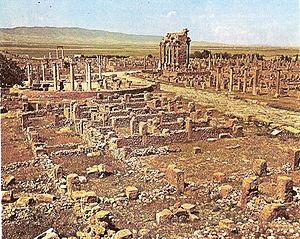 |
Timgad Timgad Timgad , called Thamugas or Tamugadi in old Berber) was a Roman colonial town in the Aures mountain- numidia Algeria founded by the Emperor Trajan around 100 AD. The full name of the town was Colonia Marciana Ulpia Traiana Thamugadi... |
Batna Province Batna Province Batna is a wilaya of Algeria. Capital is Batna. Localities in this province include Barika, Merouana and Timgad. Belezma National Park is there.- Administrative divisions :It is made up of 22 districts and 61 municipalities.The districts are:... , Algeria |
Cultural: (ii)(iii)(iv) |
91 hectares (224.9 acre) | 1982 | Timgad lies on the northern slopes of the Aurès mountains and was created ex nihilo as a military colony by the Emperor Trajan in AD 100. | |
 |
Tipaza | Tipaza Province Tipaza Province Tipaza or Tipasa is a province on the coast of Algeria, Its capital is Tipasa, 50 km west of the capital of Algeria.-Administrative divisions:... , Algeria |
Cultural: (iii)(iv) |
52 hectares (128.5 acre) | 1982 | Tipasa was an ancient Punic trading-post conquered by Rome and turned into a strategic base for the conquest of the kingdoms of Mauritania. It comprises a unique group of Phoenician, Roman, palaeochristian and Byzantine ruins alongside indigenous monuments such as the Kbor er Roumia, the great royal mausoleum of Mauritania. | |
| Qal'at al-Bahrain Qal'at al-Bahrain The Qal'at al-Bahrain The Qal'at al-Bahrain The Qal'at al-Bahrain (in , also known as the Bahrain Fort or Fort of Bahrain and previously as the Portugal Fort (Qal'at al Portugal) is an archaeological site located in Bahrain... – Ancient Harbour and Capital of Dilmun |
Northern Governorate Northern Governorate The Northern Governorate is one of the five governorates of Bahrain. It includes parts of the former municipalities of Al Mintaqah al Gharbiyah, Al Mintaqah al Wusta, Al Mintaqah al Shamaliyah, Jidd Haffs and Madinat Hamad.... ,  Bahrain Bahrain |
Cultural: (ii)(iii)(iv) |
32 hectares (79.1 acre) | 2005 | The site was the capital of the Dilmun, one of the most important ancient civilizations of the region. It contains the richest remains inventoried of this civilization, which was hitherto only known from written Sumerian references. | ||
| Abu Mena Abu Mena Abu Mena was a town, monastery complex and Christian pilgrimage center in Late Antique Egypt, about 45 km southwest of Alexandria. Its remains were designated a World Heritage Site in 1979... |
Alexandria Governorate, Egypt Egypt |
Cultural: (iv) |
183 hectares (452.2 acre) | 1979 | The church, baptistry, basilicas, public buildings, streets, monasteries, houses and workshops in this early Christian holy city were built over the tomb of the martyr Menas of Alexandria, who died in A.D. 296. | ||
| Ancient Thebes Thebes, Egypt Thebes is the Greek name for a city in Ancient Egypt located about 800 km south of the Mediterranean, on the east bank of the river Nile within the modern city of Luxor. The Theban Necropolis is situated nearby on the west bank of the Nile.-History:... with its Necropolis Theban Necropolis The Theban Necropolis is an area of the west bank of the Nile, opposite Thebes in Egypt. It was used for ritual burials for much of Pharaonic times, especially in the New Kingdom of Egypt.-Mortuary Temples:* Deir el-Bahri** Mortuary temple of Hatshepsut... |
Luxor Governorate, Egypt |
Cultural: (i)(iii)(vi) |
7390 hectares (18,261.1 acre) | 1979 | Thebes, the city of the god Amon, was the capital of Egypt during the period of the Middle and New Kingdoms. | ||
| Historic Cairo Islamic Cairo Islamic Cairo is a part of central Cairo noted for its historically important mosques and other Islamic monuments. It is overlooked by the Cairo Citadel.... |
Cairo Governorate, Egypt |
Cultural: (i)(v)(vi) |
524 hectares (1,294.8 acre) | 1979 | Tucked away amid the modern urban area of Cairo lies one of the world's oldest Islamic cities, with its famous mosques, madrasas, hammams and fountains. Founded in the 10th century, it became the new centre of the Islamic world, reaching its golden age in the 14th century. | ||
 |
Memphis Memphis, Egypt Memphis was the ancient capital of Aneb-Hetch, the first nome of Lower Egypt. Its ruins are located near the town of Helwan, south of Cairo.According to legend related by Manetho, the city was founded by the pharaoh Menes around 3000 BC. Capital of Egypt during the Old Kingdom, it remained an... and its Necropolis – the Pyramid Fields from Giza to Dahshur |
Giza Governorate, Egypt |
Cultural: (i)(iii)(vi) |
16359 hectares (40,423.9 acre) | 1979 | The capital of the Old Kingdom of Egypt has some extraordinary funerary monuments, including rock tombs, ornate mastabas, temples and pyramids. In ancient times, the site was considered one of the Seven Wonders of the World. | |
| Nubian Monuments from Abu Simbel to Philae | Aswan Governorate Aswan Governorate Aswan Governorate is one of the governorates of Egypt. The southernmost governorate in Upper Egypt, its capital is Aswan.The Aswan Governorate borders Qena Governorate to the north, Red Sea Governorate to the east, New Valley Governorate to the west, and Sudan to the south... , Egypt |
Cultural: (i)(iii)(vi) |
374 hectares (924.2 acre) | 1979 | This outstanding archaeological area contains such magnificent monuments as the Temples of Ramses II at Abu Simbel and the Sanctuary of Isis at Philae, which were saved from the rising waters of the Nile thanks to the International Campaign launched by UNESCO, in 1960 to 1980. | ||
| Saint Catherine Area | South Sinai Governorate, Egypt |
Cultural: (i)(iii)(iv)(vi) |
60100 hectares (148,510.2 acre) | 2002 | The Orthodox Monastery of St Catherine stands at the foot of Mount Horeb where, the Old Testament records, Moses received the Tablets of the Law. The mountain is known and revered by Muslims as Jebel Musa. The entire area is sacred to three world religions: Christianity, Islam, and Judaism. | ||
| Wadi Al-Hitan (Whale Valley) Wadi Al-Hitan Wadi Al-Hitan is a paleontological site in the Al Fayyum Governorate of Egypt, some 150 km southwest of Cairo. It was designated a UNESCO World Heritage Site in July 2005 for its hundreds of fossils of some of the earliest forms of whale, the archaeoceti... |
Faiyum Governorate, Egypt |
Natural: (viii) |
20015 hectares (49,458.1 acre) | 2005 | Located in a desert, the site contains fossil remains of the now extinct Archaeoceti Archaeoceti Archaeocetes, or "ancient whales", are a paraphyletic group of cetaceans that gave rise to the modern cetaceans.The archaeocetes were once thought to have evolved from the mesonychids, based on dental characteristics... , a suborder of whales, showing the evolution of the whales Evolution of cetaceans The cetaceans are marine mammal descendants of land mammals. Their terrestrial origins are indicated by:* Their need to breathe air from the surface;* The bones of their fins, which resemble the limbs of land mammals... from a land-based to an aquatic mammal. |
||
| — | Ashur Assur Assur , was one of the capitals of ancient Assyria. The remains of the city are situated on the western bank of river Tigris, north of the confluence with the tributary Little Zab river, in modern day Iraq, more precisely in the Al-Shirqat District .Assur is also... (Qal'at Sherqat) |
Salah ad Din Governorate, Iraq Iraq |
Cultural: (iii)(iv) |
70 hectares (173 acre) | 2003 | The ancient city of Ashur is located on the Tigris River in northern Mesopotamia. The city dates back to the 3rd millennium BC. From the 14th to the 9th centuries BC it was the first capital of the Assyrian Empire. The city was destroyed by the Babylonians, but revived during the Parthian period in the 1st and 2nd centuries AD. | |
 |
Hatra Hatra Hatra is an ancient city in the Ninawa Governorate and al-Jazira region of Iraq. It is currently known as al-Hadr, a name which appears once in ancient inscriptions, and it was in the ancient Iranian province of Khvarvaran. The city lies northwest of Baghdad and southwest of Mosul.-History:Hatra... |
Ninawa Governorate Ninawa Governorate Ninawa is a governorate in northern Iraq, and the Arabic name for the biblical city of Nineveh in Assyria. It has an area of and an estimated population of 2,453,000 people in 2003. Its chief city and provincial capital is Mosul, which lies across the Tigris river from the ruins of ancient... , Iraq |
Cultural: (ii)(iii)(iv)(vi) |
324 hectares (800.6 acre) | 1985 | A large fortified city under the influence of the Parthian Empire and capital of the first Arab Kingdom, Hatra withstood invasions by the Romans in A.D. 116 and 198 thanks to its high, thick walls reinforced by towers. | |
| Samarra Samarra Sāmarrā is a city in Iraq. It stands on the east bank of the Tigris in the Salah ad-Din Governorate, north of Baghdad and, in 2003, had an estimated population of 348,700.... Archaeological City |
Salah ad Din Governorate, Iraq |
Cultural: (ii)(iii)(iv) |
15058 hectares (37,209.1 acre) | 1985 | Samarra Archaeological City is the site of a powerful Islamic capital city that ruled over the provinces of the Abbasid Empire extending from Tunisia to Central Asia for a century. The 9th-century Great Mosque and its spiral minaret are among the numerous remarkable architectural monuments of the site, 80% of which remain to be excavated. | ||
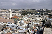 |
The Old City of Jerusalem and its Walls | Jerusalem | Cultural: (ii)(iii)(vi) |
— | — | 1985 | As a holy city for Judaism, Christianity and Islam, Jerusalem has always been of great symbolic importance. It is recognized by all three religions as the site of Abraham's sacrifice. The Wailing Wall delimits the quarters of the different religious communities, while the Resurrection rotunda in the Church of the Holy Sepulchre houses Christ's tomb. |
| Petra Petra Petra is a historical and archaeological city in the Jordanian governorate of Ma'an that is famous for its rock cut architecture and water conduits system. Established sometime around the 6th century BC as the capital city of the Nabataeans, it is a symbol of Jordan as well as its most visited... |
Ma'an Governorate Ma'an Governorate Ma'an is one of the governorates of Jordan, it is located south of Amman, Jordan's capital. Its capital is the city of Ma'an. This governorate is the largest in the kingdom of Jordan by area.-History:... ,  Jordan Jordan |
Cultural: (i)(iii)(iv) |
— | — | 1985 | Inhabited since prehistoric times, this Nabataean caravan-city, situated between the Red Sea and the Dead Sea, was an important crossroads between Arabia, Egypt and Syria-Phoenicia. Petra is half-built, half-carved into the rock, and is surrounded by mountains riddled with passages and gorges. | |
| Qasr Amra Qasr Amra Qasr Amra , often Quseir Amra or Qusayr Amra, is the best-known of the desert castles located in present-day eastern Jordan. It was built early in the 8th century by the Umayyad caliph Walid I whose dominance of the region was rising at the time... |
Zarqa Governorate Zarqa Governorate Zarqa Governorate is the third largest governorate in Jordan by population. The capital of Zarqa governorate is Zarqa City, which is the largest city in the governorate. It is located 25 km east of the Jordanian capital Amman... , Jordan |
Cultural: (i)(iii)(iv) |
— | — | 1985 | Built in the early 8th century, this exceptionally well-preserved desert castle was both a fortress with a garrison and a residence of the Umayyad caliphs. | |
| Um er-Rasas (Kastrom Mefa'a) | Madaba Governorate Madaba Governorate Madaba, is one of the governorates of Jordan, it is located south west of Amman, capital of Jordan. Its capital is Madaba. The governorate is ranked eighth by population and by area in Jordan... , Jordan |
Cultural: (i)(iv)(vi) |
24 hectares (59.3 acre) | 2005 | Most of this archaeological site, which started as a Roman military camp and grew to become a town from the 5th century, has not been excavated. It contains remains from the Roman, Byzantine and Early Muslim periods (end of 3rd to 9th centuries AD) and a fortified Roman military camp. | ||
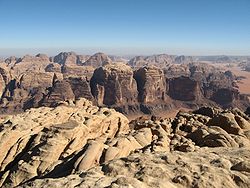 |
Wadi Rum Wadi Rum Wadi Rum also known as The Valley of the Moon is a valley cut into the sandstone and granite rock in south Jordan at to the east of Aqaba. It is the largest wadi in Jordan. The name Rum most likely comes from an Aramaic root meaning 'high' or 'elevated'. To reflect its proper Arabic... Protected Area |
Aqaba Governorate Aqaba Governorate Aqaba is one of the governorates of Jordan, located south of Amman, capital of Jordan. Its capital is Aqaba. It is the fourth largest governorate in Jordan by area and is ranked 10th by population.... , Jordan |
Mixed: (iii)(v)(vii) |
74180 hectares (183,302.6 acre) | 2005 | The 74,000-hectare property, inscribed as a mixed natural and cultural site, is situated in southern Jordan, near the border with Saudi Arabia. It features a varied desert landscape, as well as 25,000 rock carvings with 20,000 inscriptions trace the evolution of human thought and the early development of the alphabet. | |
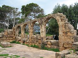
| Anjar Anjar, Lebanon Anjar , also known as Haoush Mousa , is a town of Lebanon located in the Bekaa Valley. The population is 2,400, consisting almost entirely of Armenians. The total area is about twenty square kilometers... |
Beqaa Governorate Beqaa Governorate Beqaa is a governorate in Lebanon with a population of 750,000 inhabitants.-Geography:The Beqaa governorate covers an area of 4,429 km². Béqaa is the primary center of Lebanon's agriculture. The Beqaa governorate forms the main geographical extension of Lebanon and it lies between the Western... ,  Lebanon Lebanon |
Cultural: (iii)(iv) |
— | — | 1984 | The city of Anjar was founded by Caliph Walid I at the beginning of the 8th century. The ruins reveal a very regular layout, reminiscent of the palace-cities of ancient times, and are a unique testimony to city planning under the Umayyads. | |
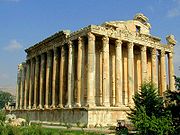 |
Baalbek Baalbek Baalbek is a town in the Beqaa Valley of Lebanon, altitude , situated east of the Litani River. It is famous for its exquisitely detailed yet monumentally scaled temple ruins of the Roman period, when Baalbek, then known as Heliopolis, was one of the largest sanctuaries in the Empire... |
Beqaa Governorate Beqaa Governorate Beqaa is a governorate in Lebanon with a population of 750,000 inhabitants.-Geography:The Beqaa governorate covers an area of 4,429 km². Béqaa is the primary center of Lebanon's agriculture. The Beqaa governorate forms the main geographical extension of Lebanon and it lies between the Western... , Lebanon |
Cultural: (i)(iv) |
— | — | 1984 | Baalbek, where a triad of deities was worshipped, was known as Heliopolis during the Hellenistic period. It retained its religious function during Roman times, when the sanctuary of the Heliopolitan Jupiter attracted thousands of pilgrims. |
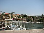 |
Byblos Byblos Byblos is the Greek name of the Phoenician city Gebal . It is a Mediterranean city in the Mount Lebanon Governorate of present-day Lebanon under the current Arabic name of Jubayl and was also referred to as Gibelet during the Crusades... |
Mount Lebanon Governorate Mount Lebanon Governorate Mount Lebanon is one of the Governorates of Lebanon. Its capital is Baabda. The overwhelming majority of its population is Maronites, Greek Orthodox, and Melkite Greek Catholic Christians... , Lebanon |
Cultural: (iii)(iv)(vi) |
— | — | 1984 | The ruins of many successive civilizations are found at Byblos, one of the oldest Phoenician cities. Inhabited since Neolithic times, it has been closely linked to the legends and history of the Mediterranean region for thousands of years. |
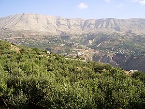 |
Ouadi Qadisha Kadisha Valley The Kadisha Valley is a valley that lies within the Becharre and Zgharta Districts of the North Governorate of Lebanon. The valley is a deep gorge carved by the Kadisha River, also known as the Nahr Abu Ali when it reaches Tripoli... (the Holy Valley) and the Forest of the Cedars of God Cedars of God The Cedars of God is one of the the last vestiges of the extensive forests of the Cedars of Lebanon that thrived across Mount Lebanon in ancient times. Their timber was exploited by the Assyrians, Babylonians and Persians as well as the Phoenicians... (Horsh Arz el-Rab) |
North Lebanon Governorate, Lebanon |
Cultural: (iii)(iv) |
— | — | 1998 | The Qadisha valley is one of the most important early Christian monastic settlements in the world. Nearby are the remains of the great forest of cedars of Lebanon, highly prized in antiquity for the construction of great religious buildings. |
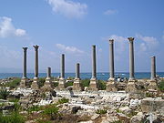 |
Tyre | South Lebanon Governorate, Lebanon |
Cultural: (iii)(vi) |
154 hectares (380.5 acre) | 1984 | Tyre ruled the seas and founded prosperous colonies such as Cadiz and Carthage, but its historical role declined at the end of the Crusades. There are important archaeological remains, mainly from Roman times. | |
| Archaeological Site of Cyrene Cyrene, Libya Cyrene was an ancient Greek colony and then a Roman city in present-day Shahhat, Libya, the oldest and most important of the five Greek cities in the region. It gave eastern Libya the classical name Cyrenaica that it has retained to modern times.Cyrene lies in a lush valley in the Jebel Akhdar... |
Jabal al Akhdar, Libya Libya |
Cultural: (ii)(iii)(vi) |
— | — | 1982 | A colony of the Greeks of Thera, Cyrene was one of the principal cities in the Hellenic world. It was Romanized and remained a great capital until the earthquake of 365. A thousand years of history is written into its ruins, which have been famous since the 18th century. | |
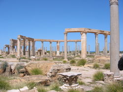 |
Archaeological Site of Leptis Magna Leptis Magna Leptis Magna also known as Lectis Magna , also called Lpqy, Neapolis, Lebida or Lebda to modern-day residents of Libya, was a prominent city of the Roman Empire. Its ruins are located in Khoms, Libya, east of Tripoli, on the coast where the Wadi Lebda meets the sea... |
Khoms, Libya |
Cultural: (i)(ii)(iii) |
— | — | 1982 | Leptis Magna was enlarged and embellished by Septimius Severus, who was born there and later became emperor. It was one of the most beautiful cities of the Roman Empire, with its imposing public monuments, harbour, market-place, storehouses, shops and residential districts. |
 |
Archaeological Site of Sabratha Sabratha Sabratha, Sabratah or Siburata , in the Zawiya District in the northwestern corner of modern Libya, was the westernmost of the "three cities" of Tripolis. From 2001 to 2007 it was the capital of the former Sabratha wa Sorman District. It lies on the Mediterranean coast about west of Tripoli... |
Zawiya District, Libya |
Cultural: (iii) |
— | — | 1982 | A Phoenician trading-post that served as an outlet for the products of the African hinterland, Sabratha was part of the short-lived Numidian Kingdom of Massinissa before being Romanized and rebuilt in the 2nd and 3rd centuries A.D. |
| Old Town of Ghadamès Ghadames Ghadames or Ghadamis is an oasis town in the Nalut District of the Fezzan region in southwestern Libya.-Geography:Ghadames lies roughly to the southwest of Tripoli, near the borders with Algeria and Tunisia. Ghadames borders Illizi Province, Algeria and Tataouine Governorate, Tunisia.The oasis... |
Nalut District, Libya |
Cultural: (v) |
— | — | 1986 | Ghadamès, known as 'the pearl of the desert', stands in an oasis. It is one of the oldest pre-Saharan cities and an outstanding example of a traditional settlement. | |
 |
Rock-Art Sites of Tadrart Acacus | Fezzan Fezzan Fezzan is a south western region of modern Libya. It is largely desert but broken by mountains, uplands, and dry river valleys in the north, where oases enable ancient towns and villages to survive deep in the otherwise inhospitable Sahara.-Name:... , Libya |
Cultural: (iii) |
— | — | 1985 | The rocky massif has thousands of cave paintings in very different styles, dating from 12,000 BCE to 100 CE. |
 |
Ancient Ksour of Ouadane Ouadane Ouadane or Wadan is a small town in the desert region of central Mauritania, situated on the southern edge of the Adrar Plateau, 93 km northeast of Chinguetti. The town was a staging post in the trans-Saharan trade and for caravans transporting slabs of salt from the mines at Idjil. A... , Chinguetti Chinguetti Chinguetti is a ksar or medieval trading centre in northern Mauritania, lying on the Adrar Plateau east of Atar.Founded in the 13th century, as the center of several trans-Saharan trade routes, this tiny city continues to attract a handful of visitors who admire its spare architecture, exotic... , Tichitt and Oualata Oualata Oualata or Walata is a small oasis town in south east Mauritania that was important in the thirteenth and fourteenth centuries as the southern terminus of a trans-Saharan trade route... |
Ouadane Ouadane Ouadane or Wadan is a small town in the desert region of central Mauritania, situated on the southern edge of the Adrar Plateau, 93 km northeast of Chinguetti. The town was a staging post in the trans-Saharan trade and for caravans transporting slabs of salt from the mines at Idjil. A... , Chinguetti Chinguetti Chinguetti is a ksar or medieval trading centre in northern Mauritania, lying on the Adrar Plateau east of Atar.Founded in the 13th century, as the center of several trans-Saharan trade routes, this tiny city continues to attract a handful of visitors who admire its spare architecture, exotic... , Tichitt, and Oualata Oualata Oualata or Walata is a small oasis town in south east Mauritania that was important in the thirteenth and fourteenth centuries as the southern terminus of a trans-Saharan trade route... ,  Mauritania Mauritania |
Cultural: (iii)(iv)(v) |
— | — | 1996 | Founded in the 11th and 12th centuries to serve the caravans crossing the Sahara, these trading and religious centres became focal points of Islamic culture. They have managed to preserve an urban fabric that evolved between the 12th and 16th centuries. |
| Banc d'Arguin National Park Banc d'Arguin National Park The Banc d'Arguin National Park lies in Western Africa on the west coast of Mauritania between Nouakchott and Nouadhibou. The World Heritage Site is a major breeding site for migratory birds. A wide range of species include flamingos, broad-billed sandpipers, pelicans and terns. Much of the... |
Nouadhibou Nouadhibou Nouadhibou is the second largest city in Mauritania and serves as a major commercial centre. The city itself has about 75,000 inhabitants expanding to over 90,000 in the larger metropolitan area. It is situated on a 40-mile peninsula or headland called Ras Nouadhibou, Cap Blanc, or Cabo Blanco, of... and Azefal, Mauritania |
Natural: (ix)(x) |
1200000 hectares (2,965,262 acre) | 1989 | The park consists of sand dunes, coastal swamps, small islands, and shallow bodies of water, all bordering the coast of the Atlantic Ocean. Birds are often found to migrate in the area, accompanied by various species of sea turtles and dolphins, whose presence fishermen often use to attract fish. | ||
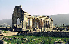 |
Archaeological Site of Volubilis Volubilis Volubilis is an archaeological site in Morocco situated near Meknes between Fez and Rabat along the N13 road. The nearest town is Moulay Idriss. Volubilis features the best preserved Roman ruins in this part of northern Africa... |
Meknès-Tafilalet Meknès-Tafilalet Meknès-Tafilalet is one of the sixteen regions of Morocco. It is situated in north-central Morocco, bordering Algeria. It covers an area of 79,210 km² and has a population of 2,141,527... ,  Morocco Morocco |
Cultural: (ii)(iii)(iv)(vi) |
42 hectares (103.8 acre) | 1997 | The important Roman Ancient Rome Ancient Rome was a thriving civilization that grew on the Italian Peninsula as early as the 8th century BC. Located along the Mediterranean Sea and centered on the city of Rome, it expanded to one of the largest empires in the ancient world.... outpost of Volubilis was founded in the 3rd century BCE to become the capital of Mauritania Mauritania Mauritania is a country in the Maghreb and West Africa. It is bordered by the Atlantic Ocean in the west, by Western Sahara in the north, by Algeria in the northeast, by Mali in the east and southeast, and by Senegal in the southwest... . It contained many buildings, the remains of which have survived extensively to this day. |
|
| Historic City of Meknes Meknes Meknes is a city in northern Morocco, located from the capital Rabat and from Fes. It is served by the A2 expressway between those two cities and by the corresponding railway. Meknes was the capital of Morocco under the reign of Moulay Ismail , before it was relocated to Marrakech. The... |
Meknès-Tafilalet Meknès-Tafilalet Meknès-Tafilalet is one of the sixteen regions of Morocco. It is situated in north-central Morocco, bordering Algeria. It covers an area of 79,210 km² and has a population of 2,141,527... , Morocco |
Cultural: (iv) |
— | — | 1996 | The former capital was founded in the 11th century and turned into an impressive city in Spanish-Moorish style during the 17th and 18th centuries. | |
 |
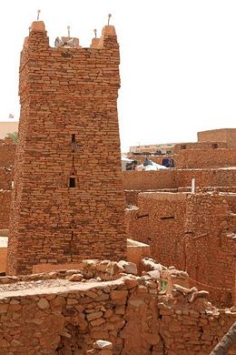
Ksar of Ait-Ben-Haddou | Souss-Massa-Draâ Souss-Massa-Draâ Souss-Massa-Draâ is one of the sixteen regions of Morocco. It is situated in central Morocco. It covers an area of 70,880 km² and has a population of 3,113,653 . The capital is Agadir... , Morocco |
Cultural: (iv)(v) |
3 hectares (7.4 acre) | 1987 | The ksar Ksar Ksar is the Arabic term for "castle", loaned from Latin castrum.The Berber equivalent is aghrem or ighrman .... is a group of earthen building surrounded by high walls, a traditional pre-Saharan habitat. |
|
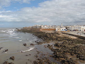 |
Medina of Essaouira (formerly Mogador) Essaouira Mogador redirects here, for the hamlet in Surrey see Mogador, Surrey.Essaouira is a city in the western Moroccan economic region of Marrakech-Tensift-Al Haouz, on the Atlantic coast. Since the 16th century, the city has also been known by its Portuguese name of Mogador or Mogadore... |
Marrakesh-Tensift-El Haouz Marrakesh-Tensift-El Haouz Marrakesh-Tensift-El Haouz is one of the sixteen regions of Morocco. It is situated in central Morocco. It covers an area of 31,160 km² and has a population of 3,102,652... , Morocco |
Cultural: (ii)(iv) |
30 hectares (74.1 acre) | 2001 | The fortified seaport built during the late 18th century has a mix of North African and European architecture, and been a major trading hub between Sahara and Europe. | |
| Medina of Fez Fes el Bali Fes el Bali is the oldest and walled part of Fes, Morocco. Fes el Bali was originally founded as the capital of the Idrisid Dynasty in between 789 and 808 AD... |
Fez Fes Fes or Fez is the second largest city of Morocco, after Casablanca, with a population of approximately 1 million . It is the capital of the Fès-Boulemane region.... , Morocco |
Cultural: (ii)(v) |
280 hectares (691.9 acre) | 1981 | The former capital was founded in the 9th century and features the world's oldest university. The urban fabric and principal monuments date from the 13th and 14th centuries. | ||
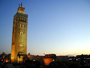 |
Medina of Marrakesh | Marrakesh-Tensift-El Haouz Marrakesh-Tensift-El Haouz Marrakesh-Tensift-El Haouz is one of the sixteen regions of Morocco. It is situated in central Morocco. It covers an area of 31,160 km² and has a population of 3,102,652... , Morocco |
Cultural: (i)(ii)(iv)(v) |
1107 hectares (2,735.5 acre) | 1985 | The town was founded in the 1070s and remained a political, economic and cultural center for a long time. Monuments from that period include the Koutoubia Mosque, the kasbah Kasbah A kasbah or qassabah is a type of medina, Islamic city, or fortress .It was a place for the local leader to live and a defense when a city was under attack. A kasbah has high walls, usually without windows. Sometimes, they were built on hilltops so that they could be more easily defended... and the battlements. The city also has newer architectural jewels, including palaces. |
|
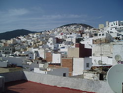 |
Medina of Tétouan (formerly known as Titawin) Tétouan Tetouan is a city in northern Morocco. The Berber name means literally "the eyes" and figuratively "the water springs". Tetouan is one of the two major ports of Morocco on the Mediterranean Sea. It lies a few miles south of the Strait of Gibraltar, and about 40 mi E.S.E. of Tangier... |
Tangier-Tetouan Tangier-Tetouan Tangier-Tetouan is one of the sixteen regions of Morocco. It is situated in north-western Morocco. It covers an area of 11,570 km² and has a population of 2,470,372... , Morocco |
Cultural: (ii)(iv)(v) |
7 hectares (17.3 acre) | 1997 | Morocco's most complete medina Medina quarter A medina quarter is a distinct city section found in many North African cities. The medina is typically walled, contains many narrow and maze-like streets... served as the main point of contact between Morocco and Andalusia Andalusia Andalusia is the most populous and the second largest in area of the autonomous communities of Spain. The Andalusian autonomous community is officially recognised as a nationality of Spain. The territory is divided into eight provinces: Huelva, Seville, Cádiz, Córdoba, Málaga, Jaén, Granada and... during the 8th century. After the reconquista Reconquista The Reconquista was a period of almost 800 years in the Middle Ages during which several Christian kingdoms succeeded in retaking the Muslim-controlled areas of the Iberian Peninsula broadly known as Al-Andalus... , the town was rebuilt by Andalusian refugees. |
|
| Portuguese City of Mazagan (El Jadida) El Jadida El Jadida is a port city on the Atlantic coast of Morocco, in the province of El Jadida. It has a population of 144,440... |
Doukkala-Abda Doukkala-Abda Doukkala-Abda ) is one of the sixteen regions of Morocco. It is situated in west-central Morocco. It covers an area of 13,285 km² and has a population of 1,984,039 . The capital is Safi.The region is made up into the following provinces :... , Morocco |
Cultural: (ii)(iv) |
8 hectares (19.8 acre) | 2004 | The fortification was built in Renaissance Renaissance The Renaissance was a cultural movement that spanned roughly the 14th to the 17th century, beginning in Italy in the Late Middle Ages and later spreading to the rest of Europe. The term is also used more loosely to refer to the historical era, but since the changes of the Renaissance were not... military design in the early 16th century, and taken over by Morocco in 1769. Surviving Portugese buildings include the cistern and a Gothic Gothic architecture Gothic architecture is a style of architecture that flourished during the high and late medieval period. It evolved from Romanesque architecture and was succeeded by Renaissance architecture.... church. |
||
| — | Aflaj Irrigation Systems of Oman | Sharqiyah and Batinah Al Batinah Region Al Bāţinah is one of the regions of Oman.Al Batinah Region, otherwise known as Al Batinah, occupies an important location on the coast of Gulf of Oman. It lies between Khatmat Malahah in the north and Ras AL Hamra in the south and confined between the Al Hajar Mountains in the west and the Gulf... Regions,  Oman Oman |
Cultural: (v) |
1456 hectares (3,597.9 acre) | 2006 | The property includes five aflaj irrigation systems and is representative of some 3,000 such systems still in use in Oman. The origins of this system of irrigation may date back to AD 500, but archaeological evidence suggests that irrigation systems existed in this extremely arid area as early as 2500 BC. | |
| — | Archaeological Sites of Bat, Al-Khutm and Al-Ayn | Ad Dhahirah Region, Oman |
Cultural: (iii)(iv) |
— | — | 1988 | The protohistoric site of Bat lies near a palm grove in the interior of the Sultanate of Oman. Together with the neighbouring sites, it forms the most complete collection of settlements and necropolises from the 3rd millennium B.C. in the world. |
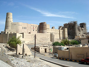 |
Bahla Fort Bahla Fort Bahla Fort is one of four historic fortresses situated at the foot of the Djebel Akhdar highlands in Oman. It was built in the 13th and 14th centuries, when the oasis of Bahla was prosperous under the control of the Banu Nebhan tribe. The fort's ruined adobe walls and towers rise some... |
Ad Dakhiliyah Region Ad Dakhiliyah Region Ad Dakhiliyah is one of the regions of Oman with Nizwa town as the regional center.Ad Dakhiliyah Region consists of eight wilayats: Nizwa, Samail, Bahla, Adam, Al Hamra, Manah, Izki and Bid Bid.... , Oman |
Cultural: (iv) |
— | — | 1987 | The oasis of Bahla owes its prosperity to the Banu Nebhan, the dominant tribe in the area from the 12th to the end of the 15th century. The ruins of the immense fort, with its walls and towers of unbaked brick and its stone foundations, is a remarkable example of this type of fortification and attests to the power of the Banu Nebhan. |
| — | Land of Frankincense Frankincense trail The Frankincense Trail is a site in Oman on the Incense Road. The site includes frankincense trees and the remains of a caravan oasis, which were crucial to the medieval incense trade.The Frankincense Trail has been declared a UNESCO World Heritage Site.... |
Dhofar Governorate, Oman |
Cultural: (iii)(iv) |
850 hectares (2,100.4 acre) | 2000 | The frankincense trees of Wadi Dawkah and the remains of the caravan oasis of Shisr/Wubar and the affiliated ports of Khor Rori and Al-Baleed vividly illustrate the trade in frankincense that flourished in this region for many centuries, as one of the most important trading activities of the ancient and medieval world. | |
 |
Al-Hijr Archaeological Site (Madâin Sâlih) | Al Madinah Province, Saudi Arabia Saudi Arabia |
Cultural: (ii)(iii) |
1621 hectares (4,005.6 acre) | 2008 | Formerly known as Hegra it is the largest conserved site of the civilization of the Nabataeans south of Petra in Jordan. It features well-preserved monumental tombs with decorated facades dating from the 1st century BC to the 1st century AD. | |
| At-Turaif District in ad-Dir'iyah Diriyah Al-Diriyah is a town in Saudi Arabia located on the northwestern outskirts of the Saudi capital, Riyadh. Diriyah was the original home of the Saudi royal family, and served as the capital of the first Saudi dynasty from 1744 to 1818... |
Riyadh Province, Saudi Arabia |
Cultural: (ii)(iii) |
29 hectares (71.7 acre) | 2008 | Diriyah was the first capital of the Saudi Dynasty, in the heart of the Arabian Penisula, north-west of Riyadh. It includes the remains of many palaces and an urban ensemble built on the edge of the ad-Dir’iyah oasis. | ||
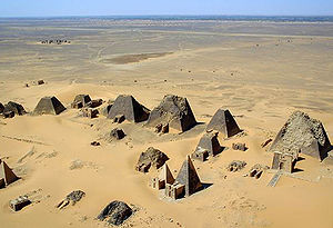 |
Archaeological Sites of the Island of Meroe Meroë Meroë Meroitic: Medewi or Bedewi; Arabic: and Meruwi) is an ancient city on the east bank of the Nile about 6 km north-east of the Kabushiya station near Shendi, Sudan, approximately 200 km north-east of Khartoum. Near the site are a group of villages called Bagrawiyah... |
River Nile State, Sudan Sudan |
Cultural: (ii)(iii)(iv)(v) |
2357 hectares (5,824.3 acre) | 2011 | The site, a semi-desert landscape between the Nile and Atbara rivers, was the heartland of the Kingdom of Kush, a major power from the 8th century B.C. to the 4th century A.D. | |
 |
Gebel Barkal and the Sites of the Napatan Region | Northern State, Sudan |
Cultural: (i)(ii)(iii)(iv)(vi) |
183 hectares (452.2 acre) | 2003 | The five sites in the Nile Valley feature temples that are a testimony to the Napata Napata Napata was a city-state of ancient Nubia on the west bank of the Nile River, at the site of modern Karima, Northern Sudan.During the 8th to 7th centuries BC, Napata was the capital of the Nubian kingdom of Kush, whence the 25th, or Nubian Dynasty conquered Egypt... n (900–270 BCE) and Meroitic Meroitic Meroitic is an adjective referring to things related to the kingdom of Meroë in pre-Islamic Sudan.* The Meroitic period was approximately 300 BC to 400 AD.* The Meroitic script was their writing system.... (270 BCE – 350 CE) cultures. |
|
| Ancient City of Aleppo | Aleppo Governorate Aleppo Governorate Aleppo Governorate is one of the fourteen governorates of Syria. It is the most populous governorate in Syria with a population of more than 4,744,000 , almost 23% of the total population of Syria. The governorate is the fifth in area with an area of 18,482 km², about 10% of the total area of... ,  Syria Syria |
Cultural: (iii)(iv) |
— | — | 1986 | Located at the crossroads of several trade routes from the 2nd millennium B.C., Aleppo was ruled successively by the Hittites, Assyrians, Arabs, Mongols, Mamelukes and Ottomans. | |
| Ancient City of Bosra | Daraa Governorate, Syria |
Cultural: (i)(iii)(vi) |
— | — | 1980 | Bosra, once the capital of the Roman province of Arabia, was an important stopover on the ancient caravan route to Mecca. A magnificent 2nd-century Roman theatre, early Christian ruins and several mosques are found within its great walls. | |
| Ancient City of Damascus | Damascus Governorate Damascus Governorate Damascus Governorate is one of the 14 governorates of Syria and consists of only the city of Damascus and the suburb of Yarmouk.... , Syria |
Cultural: (i)(ii)(iii)(iv)(vi) |
86 hectares (212.5 acre) | 1979 | Founded in the 3rd millennium B.C., Damascus is one of the oldest cities in the Middle East. In the Middle Ages, it was the centre of a flourishing craft industry, specializing in swords and lace. | ||
| Ancient Villages of Northern Syria | Syria |
Cultural: (iii)(iv)(v) |
12290 hectares (30,369.2 acre) | 2011 | Some 40 villages grouped in eight parks situated in north-western Syria provide remarkable testimony to rural life in late Antiquity and during the Byzantine period. | ||
| Crac des Chevaliers and Qal’at Salah El-Din | Homs Homs Governorate Homs Governorate is one of the fourteen muhafazat of Syria. It is situated in central Syria. Its area differs in various sources, from 40,940 km². to 42,223 km² . It is thus geographically the largest governorate of Syria. Homs Governorate has a population of 1,763,000 . The capital is... and Latakia Latakia Governorate Latakia Governorate or muhafazah al Ladhiqiyah is one of the fourteen governorates of Syria. It is situated in western Syria, bordering Turkey. Its reported area varies in different sources from 2,297 km² to 2,437 km² . The Governorate has a population of 991,000 and is one of the... Governorates, Syria |
Cultural: (ii)(iv) |
9 hectares (22.2 acre) | 2006 | These two castles represent the most significant examples illustrating the exchange of influences and documenting the evolution of fortified architecture in the Near East during the time of the Crusades (11th - 13th centuries). | ||
| Site of Palmyra | Homs Governorate Homs Governorate Homs Governorate is one of the fourteen muhafazat of Syria. It is situated in central Syria. Its area differs in various sources, from 40,940 km². to 42,223 km² . It is thus geographically the largest governorate of Syria. Homs Governorate has a population of 1,763,000 . The capital is... , Syria |
Cultural: (i)(ii)(iv) |
0.36 hectare (0.889578586854994 acre) | 1980 | An oasis in the Syrian desert, north-east of Damascus, Palmyra contains the monumental ruins of a great city that was one of the most important cultural centres of the ancient world. | ||
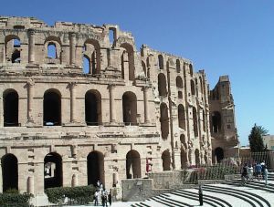 |
Amphitheatre of El Jem | Mahdia Governorate Mahdia Governorate Mahdia Governorate is one of the twenty-four governorates of Tunisia. It is situated in central-eastern Tunisia. It covers an area of 2,966 km² and has a population of 378,000... ,  Tunisia Tunisia |
Cultural: (iv)(vi) |
1.37 hectares (3.4 acre) | 1979 | The Amphitheatre of El Jem, built during the 3rd century, is North Africa's largest coliseum with a capacity of 35,000 spectators, and "illustrates the grandeur and extent of Imperial Rome." | |
 |
Archaeological Site of Carthage | Tunis Governorate Tunis Governorate Tunis Governorate the smallest and most populated of the twenty-four governorates of Tunisia. It is situated in northern Tunisia. It covers an area of and has a population of 984,000... , Tunisia |
Cultural: (ii)(iii)(vi) |
— | — | 1979 | Founded in the 9th century BCE, Carthage was developed into a trading empire spanning the Mediterranean, and was, according to UNESCO, "home to a brilliant civilization." The city was destroyed in 146 BCE in the Punic Wars Punic Wars The Punic Wars were a series of three wars fought between Rome and Carthage from 264 B.C.E. to 146 B.C.E. At the time, they were probably the largest wars that had ever taken place... at the hands of the Romans, but was later rebuilt by these. |
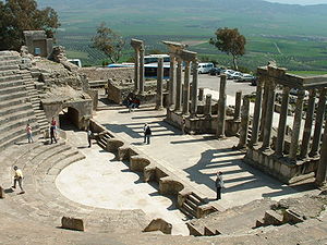 |
Dougga / Thugga Dougga Dougga or Thugga is an ancient Roman city in northern Tunisia, included in a 65 hectare archaeological site.UNESCO qualified Dougga as a World Heritage Site in 1997, believing that it represents “the best-preserved Roman small town in North Africa”... |
Béja Governorate Béja Governorate Béja Governorate is one of the twenty-four governorates of Tunisia. It is situated in northern Tunisia. It covers an area of 3,558 km² and has a population of 305,000 . The capital is Béja.... , Tunisia |
Cultural: (ii)(iii) |
70 hectares (173 acre) | 1997 | The site features the ruins of Dougga, a former capital of a Libyan Libyan A Libyan is a person or thing of, from, or related to Libya in North Africa.The term Libyan may also refer to:* A person from Libya, or of Libyan descent. For information about the Libyan people, see Demographics of Libya and Culture of Libya. For specific persons, see List of Libyans.* Libyan... –Punic state, which flourished under Ancient Rome Ancient Rome Ancient Rome was a thriving civilization that grew on the Italian Peninsula as early as the 8th century BC. Located along the Mediterranean Sea and centered on the city of Rome, it expanded to one of the largest empires in the ancient world.... and the Byzantine Empire Byzantine Empire The Byzantine Empire was the Eastern Roman Empire during the periods of Late Antiquity and the Middle Ages, centred on the capital of Constantinople. Known simply as the Roman Empire or Romania to its inhabitants and neighbours, the Empire was the direct continuation of the Ancient Roman State... , but declined in the Islamic period. |
|
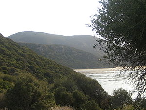 |
Ichkeul National Park | Bizerte Governorate Bizerte Governorate Bizerte Governorate is the northernmost of the 24 governorates of Tunisia. It is situated in northern Tunisia. It covers an area of 3,685 km² and has a population of 524,000 . The capital is Bizerte... , Tunisia |
Natural: (x) |
12600 hectares (31,135.3 acre) | 1980 | Ichkeul Lake Ichkeul Lake Ichkeul Lake is a lake in northern Tunisia near the shore of the Mediterranean Sea. The lake and wetlands of Ichkeul National Park are an important stopping-over point for hundreds of thousands of migrating birds each year. Among the lake's visitors are ducks, geese, storks, and pink flamingoes... and the surrounding wetlands is a major stopover for hundreds of thousands of migrating bird, including duck Duck Duck is the common name for a large number of species in the Anatidae family of birds, which also includes swans and geese. The ducks are divided among several subfamilies in the Anatidae family; they do not represent a monophyletic group but a form taxon, since swans and geese are not considered... s, geese, stork Stork Storks are large, long-legged, long-necked wading birds with long, stout bills. They belong to the family Ciconiidae. They are the only family in the biological order Ciconiiformes, which was once much larger and held a number of families.... s and pink flamingos. Ichkeul is the last remaining lake in a chain that once extended across North Africa. |
|
| Kairouan Kairouan Kairouan , also known as Kirwan or al-Qayrawan , is the capital of the Kairouan Governorate in Tunisia. Referred to as the Islamic Cultural Capital, it is a UNESCO World Heritage site. The city was founded by the Arabs around 670... |
Kairouan Governorate Kairouan Governorate Kairouan Governorate is one of the twenty-four governorates of Tunisia. It is an inland province, situated in the centre of the country. It covers an area of 6,712 km² and has a population of 546,209... , Tunisia |
Cultural: (i)(ii)(iii)(v)(vi) |
68 hectares (168 acre) | 1988 | The city was founded in 670 and flourished as a capital in the 9th century. Its heritage includes the Mosque of Uqba and the Mosque of the Three Gates. | ||
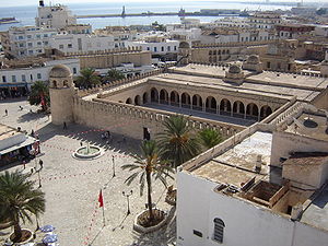 |
Medina of Sousse | Sousse Governorate Sousse Governorate Sousse Governorate is one of the twenty-four governorates of Tunisia. It is situated in north-eastern Tunisia. It covers an area of 2,621 km² and has a population of 544,000... , Tunisia |
Cultural: (iii)(iv)(v) |
32 hectares (79.1 acre) | 1988 | The city was an important commercial and military port during the 9th century and a typical example of a town dating from the first centuries of Islam. | |
 |
Medina of Tunis | Tunis Governorate Tunis Governorate Tunis Governorate the smallest and most populated of the twenty-four governorates of Tunisia. It is situated in northern Tunisia. It covers an area of and has a population of 984,000... , Tunisia |
Cultural: (ii)(iii)(v) |
296 hectares (731.4 acre) | 1979 | The medina Medina quarter A medina quarter is a distinct city section found in many North African cities. The medina is typically walled, contains many narrow and maze-like streets... contains 700 monuments, including palaces, mosques, mausoleums, madrasah Madrasah Madrasah is the Arabic word for any type of educational institution, whether secular or religious... and fourtains, testifying to Tunis golden age from the 12th to the 16th century. |
|
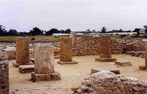 |
Punic Town of Kerkuane Kerkouane Kerkouane is a Punic city in northeastern Tunisia, near Cape Bon. This Phoenician city was probably abandoned during the First Punic War , and as a result was not rebuilt by the Romans. It had existed for almost 400 years.... and its Necropolis Necropolis of Kerkouane A necropolis is located approximately northwest of the Punic city of Kerkouane, Tunisia. The necropolis consists of a series of vaults set in a seaside hill, four primary chamber-tombs, and a surrounding burial area... |
Nabeul Governorate Nabeul Governorate Nabeul Governorate is one of the 24 governorates of Tunisia. It is situated in north-eastern Tunisia. It covers an area of 2,788 km² and has a population of 694,000 . The capital is Nabeul.-Municipalities:... , Tunisia |
Cultural: (iii) |
— | — | 1985 | The city was abandoned in 250 BCE during the First Punic War First Punic War The First Punic War was the first of three wars fought between Ancient Carthage and the Roman Republic. For 23 years, the two powers struggled for supremacy in the western Mediterranean Sea, primarily on the Mediterranean island of Sicily and its surrounding waters but also to a lesser extent in... , and remains the only example of a Phoenicio Phoenicia Phoenicia , was an ancient civilization in Canaan which covered most of the western, coastal part of the Fertile Crescent. Several major Phoenician cities were built on the coastline of the Mediterranean. It was an enterprising maritime trading culture that spread across the Mediterranean from 1550... –Punic settlement. |
 |
Historic Town of Zabid Zabid Zabid is a town with an urban population of around 23,000 persons on Yemen's western coastal plain. The town, named after Wadi Zabid, the wadi to its south, is one of the oldest towns in Yemen... |
Al Hudaydah Governorate Al Hudaydah Governorate Al Hudaydah is a governorate of Yemen. Its capital is Al Hudaydah.This governorate borders the Red Sea and is part of the narrow Tihamah region... ,  Yemen Yemen |
Cultural: (iii) |
— | — | 1993 | Zabid was the capital of Yemen from the 13th to the 15th century. The city played an important role in the Arab and Muslim world for many centuries because of its Islamic university. |
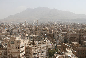 |
Old City of Sana'a Sana'a -Districts:*Al Wahdah District*As Sabain District*Assafi'yah District*At Tahrir District*Ath'thaorah District*Az'zal District*Bani Al Harith District*Ma'ain District*Old City District*Shu'aub District-Old City:... |
Sana Governorate, Yemen |
Cultural: (iv)(v)(vi) |
— | — | 1986 | Sana’a has been inhabited for more than 2,500 years. In the 7th and 8th centuries the city became a major centre for the propagation of Islam. This religious and political heritage can be seen in the 103 mosques, 14 hammams and over 6,000 houses, all built before the 11th century. |
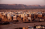 |
Old Walled City of Shibam Shibam Shibam is a town in Yemen with about 7,000 inhabitants. The first known inscription about the city dates from the 3rd century AD... |
Hadhramaut Governorate Hadhramaut Governorate Hadhramaut or Hadramawt is a governorate of Yemen. Lying within the large historical region of Hadhramaut, it is the country's largest governorate.-Overview:... , Yemen |
Cultural: (iii)(iv)(v) |
— | — | 1982 | The 16th-century city of Shibam is one of the oldest and best examples of urban planning based on the principle of vertical construction. |
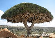 |
Socotra Archipelago Socotra Socotra , also spelt Soqotra, is a small archipelago of four islands in the Indian Ocean. The largest island, also called Socotra, is about 95% of the landmass of the archipelago. It lies some east of the Horn of Africa and south of the Arabian Peninsula. The island is very isolated and through... |
Hadhramaut Governorate Hadhramaut Governorate Hadhramaut or Hadramawt is a governorate of Yemen. Lying within the large historical region of Hadhramaut, it is the country's largest governorate.-Overview:... , Yemen |
Natural: (x) |
410460 hectares (1,014,267.9 acre) | 2008 | Socotra Archipelago, in the northwest Indian Ocean near the Gulf of Aden, is 250 km long and comprises four islands and two rocky islets which appear as a prolongation of the Horn of Africa. The site is of universal importance because of its biodiversity with rich and distinct flora and fauna. |
External links
- UNESCO World Heritage Centre - Official site
- List of UNESCO World Heritage Sites - Official site
- VRheritage.org - documentation of World Heritage Sites
- Worldheritage-Forum - Information and Weblog on World Heritage Issues