

Fezzan
Encyclopedia
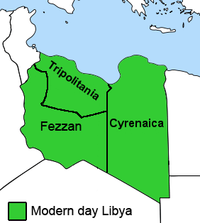
Libya
Libya is an African country in the Maghreb region of North Africa bordered by the Mediterranean Sea to the north, Egypt to the east, Sudan to the southeast, Chad and Niger to the south, and Algeria and Tunisia to the west....
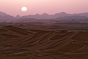
. It is largely desert
Desert
A desert is a landscape or region that receives an extremely low amount of precipitation, less than enough to support growth of most plants. Most deserts have an average annual precipitation of less than...
but broken by mountains, uplands, and dry river valleys (wadi
Wadi
Wadi is the Arabic term traditionally referring to a valley. In some cases, it may refer to a dry riverbed that contains water only during times of heavy rain or simply an intermittent stream.-Variant names:...
s) in the north, where oases enable ancient towns and villages to survive deep in the otherwise inhospitable Sahara
Sahara
The Sahara is the world's second largest desert, after Antarctica. At over , it covers most of Northern Africa, making it almost as large as Europe or the United States. The Sahara stretches from the Red Sea, including parts of the Mediterranean coasts, to the outskirts of the Atlantic Ocean...
.
Name
Fezzan derives from the region's Latin Roman name Phasania or Phazania, which may mean "the country of the pheasants" or is related to the Biblical name PhutPhut
Phut or Put is the third son of Ham , in the biblical Table of Nations .Put is associated with Ancient Libya by many early writers...
.
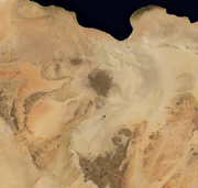
Geography
Tibesti Mountains
The Tibesti Mountains are a range of inactive volcanoes located on the northern edge of the Chad Basin in the Borkou- and Tibesti Region of northern Chad. The massif is one of the most prominent features of the Central-Sahara desert and covers an area of approximately 100,000 km². The northern...
crossing the Chad
Chad
Chad , officially known as the Republic of Chad, is a landlocked country in Central Africa. It is bordered by Libya to the north, Sudan to the east, the Central African Republic to the south, Cameroon and Nigeria to the southwest, and Niger to the west...
ian border and a sprinkling of remote oases and border posts, are the only parts of the Fezzan able to support settled populations. Large dune seas known as ergs
Erg (landform)
An erg is a broad, flat area of desert covered with wind-swept sand with little or no vegetative cover. The term takes its name from the Arabic word ʿarq , meaning "dune field"...
cover much of the remaining land.
History
Trans-Saharan trade
Trans-Saharan trade requires travel across the Sahara to reach sub-Saharan Africa. While existing from prehistoric times, the peak of trade extended from the 8th century until the late 16th century.- Increasing desertification and economic incentive :...
routes between the Carthaginians -- and later the Roman Empire
Roman Empire
The Roman Empire was the post-Republican period of the ancient Roman civilization, characterised by an autocratic form of government and large territorial holdings in Europe and around the Mediterranean....
-- and Sahel
Sahel
The Sahel is the ecoclimatic and biogeographic zone of transition between the Sahara desert in the North and the Sudanian Savannas in the south.It stretches across the North African continent between the Atlantic Ocean and the Red Sea....
ian states of west and central Africa.
Roman Septimius Flaccus in AD 50 led a military expedition that reached the actual Fezzan
Fezzan
Fezzan is a south western region of modern Libya. It is largely desert but broken by mountains, uplands, and dry river valleys in the north, where oases enable ancient towns and villages to survive deep in the otherwise inhospitable Sahara.-Name:...
and went further south. For two/three centuries after this invasion, Fezzan -as part of the Garamantes State- was a client state of the Roman Empire and benefited from Roman civilization.
With the end of the Roman empire and the following commercial crisis, Fezzan started to lose importance: the population was greatly reduced because of the desertification process of the Sahara
Sahara
The Sahara is the world's second largest desert, after Antarctica. At over , it covers most of Northern Africa, making it almost as large as Europe or the United States. The Sahara stretches from the Red Sea, including parts of the Mediterranean coasts, to the outskirts of the Atlantic Ocean...
during the Middle Ages
Middle Ages
The Middle Ages is a periodization of European history from the 5th century to the 15th century. The Middle Ages follows the fall of the Western Roman Empire in 476 and precedes the Early Modern Era. It is the middle period of a three-period division of Western history: Classic, Medieval and Modern...
.
During the 13th and 14th century, portions of the Fezzan were part of the Kanem Empire
Kanem Empire
The Kanem Empire was located in the present countries of Chad, Nigeria and Libya. At its height it encompassed an area covering not only much of Chad, but also parts of southern Libya , eastern Niger and north-eastern Nigeria...
, while the Ottoman
Ottoman Empire
The Ottoman EmpireIt was usually referred to as the "Ottoman Empire", the "Turkish Empire", the "Ottoman Caliphate" or more commonly "Turkey" by its contemporaries...
rulers of North Africa asserted their control over the region in the 17th century.
Beginning in 1911, the Fezzan was occupied by Italy. However, Italy's control of the region was precarious until at least 1923, with the rise of the Italian Fascist regime. The Italians were resisted in their early attempts at conquest by Berber and Arab adherents to the militant Sanusiya Sufi religious order. The Tuareg clans of the region were only pacified by European expansion before the Second World War and some of them collaborated with the Italian Army in the North African Campaign
North African campaign
During the Second World War, the North African Campaign took place in North Africa from 10 June 1940 to 13 May 1943. It included campaigns fought in the Libyan and Egyptian deserts and in Morocco and Algeria and Tunisia .The campaign was fought between the Allies and Axis powers, many of whom had...
.
Free French troops occupied Murzuk
Murzuk
Murzuk is an oasis town and the capital of the Murzuq District in the Fezzan region of southwest Libya. Murzuk lies on the northern edge of the Murzuq Desert, a desert of ergs or great sand dunes, and section of the Sahara Desert.-History:...
, a chief town of Fezzan, on 16 January 1943, and proceeded to administer Fezzan with a staff stationed in Sabha. But French administration was largely exercised through Fezzan notables of the family of Sayf an Nasr. Disquieting to the tribes in western Fezzan was the administrative attachment of Ghat, and its surrounding area, to French occupied southern Algeria
Algeria
Algeria , officially the People's Democratic Republic of Algeria , also formally referred to as the Democratic and Popular Republic of Algeria, is a country in the Maghreb region of Northwest Africa with Algiers as its capital.In terms of land area, it is the largest country in Africa and the Arab...
. However, when the French military control ceased in 1951, all of Fezzan became part of the Kingdom of Libya
Kingdom of Libya
The Kingdom of Libya, originally called the United Libyan Kingdom came into existence upon independence on 24 December 1951 and lasted until a coup d'état led by Muammar Gaddafi on 1 September 1969 overthrew King Idris of Libya and established the Libyan Arab Republic.- Constitution :Under the...
.
Fezzan was a stronghold for Libya
Libya
Libya is an African country in the Maghreb region of North Africa bordered by the Mediterranean Sea to the north, Egypt to the east, Sudan to the southeast, Chad and Niger to the south, and Algeria and Tunisia to the west....
n leader Muammar Gaddafi
Muammar Gaddafi
Muammar Muhammad Abu Minyar Gaddafi or "September 1942" 20 October 2011), commonly known as Muammar Gaddafi or Colonel Gaddafi, was the official ruler of the Libyan Arab Republic from 1969 to 1977 and then the "Brother Leader" of the Libyan Arab Jamahiriya from 1977 to 2011.He seized power in a...
throughout much of the 2011 Libyan civil war
2011 Libyan civil war
The 2011 Libyan civil war was an armed conflict in the North African state of Libya, fought between forces loyal to Colonel Muammar Gaddafi and those seeking to oust his government. The war was preceded by protests in Benghazi beginning on 15 February 2011, which led to clashes with security...
, though starting in July, anti-Gaddafi forces
Anti-Gaddafi forces
The anti-Gaddafi forces were Libyan groups that opposed and militarily defeated the government of Muammar Gaddafi, killing him in the process. These opposition forces included organised and armed militia groups, participants in the 2011 Libyan civil war, Libyan diplomats who switched their...
began to gain ground
Fezzan campaign
The Fezzan campaign was a military campaign conducted by the National Liberation Army to take control of southwestern Libya during the 2011 Libyan civil war. During April to June 2011, anti-Gaddafi forces gained control of most of the eastern part of the southern desert region during the...
, eventually taking control of the region's largest city of Sabha in mid-to-late September.
Administration
Fezzan was a province under the Ottoman TurksOttoman Empire
The Ottoman EmpireIt was usually referred to as the "Ottoman Empire", the "Turkish Empire", the "Ottoman Caliphate" or more commonly "Turkey" by its contemporaries...
and Italy, and a province (wilayah
Wilayah
A wilāyah or vilâyet , or vilayat in Urdu and Turkish, is an administrative division, usually translated as "province", rarely as "governorate". The word comes from the Arabic "w-l-y", "to govern": a wāli — "governor" — governs a wilayah, "that which is governed"...
) or governorate
Governorates of Libya
The governorates of Libya were a tenfold top-level administrative division of Libya from 1963 until 1983.They came into being on 27 April 1963...
(muhafazah
Muhafazah
A ' is a first-level administrative division of many Arab countries, and a second-level administrative division in Saudi Arabia. The term is usually translated to governorate in English, and occasionally to province. It comes from the Arabic root 'h-f-ẓ' which means to 'keep and guard'...
) of independent Libya
Libya
Libya is an African country in the Maghreb region of North Africa bordered by the Mediterranean Sea to the north, Egypt to the east, Sudan to the southeast, Chad and Niger to the south, and Algeria and Tunisia to the west....
(alongside Tripolitania
Tripolitania
Tripolitania or Tripolitana is a historic region and former province of Libya.Tripolitania was a separate Italian colony from 1927 to 1934...
and Cyrenaica
Cyrenaica
Cyrenaica is the eastern coastal region of Libya.Also known as Pentapolis in antiquity, it was part of the Creta et Cyrenaica province during the Roman period, later divided in Libia Pentapolis and Libia Sicca...
) until 1963. With the introduction of the new administrative division of Libya in 1963, Fezzan was abolished as an independent administrative unit and was divided into the muhafazat (governorates)
Governorates of Libya
The governorates of Libya were a tenfold top-level administrative division of Libya from 1963 until 1983.They came into being on 27 April 1963...
of Awbari
Awbari Governorate
Awbari Governorate or Ubari Governorate was one of the governorates of Libya from 1963 to 1973. Its capital was the town of Ubari. It was created out of the southwestern part of Fezzan. In 1973 the Awbari Governorate was merged into an altered Sabha Governorate.The governorate's population was...
and Sabha. In 1983, these administrative divisions were abolished in favour of smaller districts or baladiyah
Baladiyah
Baladiyah is a type of Arabic administrative division that can be translated as municipality or district. The plural is baladiyat . Grammatically, it is the feminine of بلدي "rural, country-, folk-"....
. The Baladiyat-system was reorganized in 1987 and was replaced in 1995 by the Sha'biyat-system.
The former Fezzan province contains the districts (Sha'biyat) of Wadi al Shatii
Wadi Al Shatii District
Wadi al Shatii , sometimes referred to as Ash Shati , is one of the districts of Libya in the central-west part of the country. Its capital is Brak. The area is mostly desert.To the west, Wadi al Shatii borders the Illizi Province of Algeria...
, Wadi al Hayaa, Jufra, Ghadames, Murzuq, Sabha and Ghat (other maps allocate Ghadames to the neighbouring region of Tripolitania
Tripolitania
Tripolitania or Tripolitana is a historic region and former province of Libya.Tripolitania was a separate Italian colony from 1927 to 1934...
). The historic capital, largest city, political and administrative centre is Sabha.
Population
The region's inhabitants include the nomadic Tuareg in the southwest and the Toubou in the southeast. These pastoralist populations often cross the borders of AlgeriaAlgeria
Algeria , officially the People's Democratic Republic of Algeria , also formally referred to as the Democratic and Popular Republic of Algeria, is a country in the Maghreb region of Northwest Africa with Algiers as its capital.In terms of land area, it is the largest country in Africa and the Arab...
, Chad
Chad
Chad , officially known as the Republic of Chad, is a landlocked country in Central Africa. It is bordered by Libya to the north, Sudan to the east, the Central African Republic to the south, Cameroon and Nigeria to the southwest, and Niger to the west...
and Niger
Niger
Niger , officially named the Republic of Niger, is a landlocked country in Western Africa, named after the Niger River. It borders Nigeria and Benin to the south, Burkina Faso and Mali to the west, Algeria and Libya to the north and Chad to the east...
freely. In the north, Arab
Arab
Arab people, also known as Arabs , are a panethnicity primarily living in the Arab world, which is located in Western Asia and North Africa. They are identified as such on one or more of genealogical, linguistic, or cultural grounds, with tribal affiliations, and intra-tribal relationships playing...
, Berber
Berber people
Berbers are the indigenous peoples of North Africa west of the Nile Valley. They are continuously distributed from the Atlantic to the Siwa oasis, in Egypt, and from the Mediterranean to the Niger River. Historically they spoke the Berber language or varieties of it, which together form a branch...
and settled Tuareg and Toubou
Toubou
The Tubu are an ethnic group that live mainly in northern Chad, but also in Libya, Niger and Sudan....
mix. While making up some 30% of the land area of Libya, the Fezzan supports little of its population. Despite this, large towns like Sabha, survive on near surface water in the wadis of the north and west. The northeast area is dominated by Haruj
Haruj
Haruj is a large volcanic field spread across in central Libya. It contains about 150 volcanoes, including numerous basaltic scoria cones and about 30 small shield volcanoes, along with craters and lava flows....
, a large and unpopulated volcanic field
Volcanic field
A volcanic field is an area of the Earth's crust that is prone to localized volcanic activity. They usually contain 10 to 100 volcanoes, such as cinder cones and are usually in clusters. Lava flows may also occur...
.
Fezzan's population has grown rapidly since the mid 20th century along with the overall growth in Libya's population, and the province's share of the national population has increased slightly.
| Year | Population | Percent ofLibya'spopulation |
|---|---|---|
| 1954 | 59,315 | 5.4 |
| 1964 | 79,326 | 5.1 |
| 1973 | 128,012 | 5.7 |
| 1984 | 213,915 | 5.9 |
| 1995 | 352,276 | 7.3 |
| 2006 | 442,090 | 7.8 |
Source: Gathered from bulletins of censuses 1964, 1973, 1995, 2006.
See also
- List of colonial heads of Fezzan
- Postage stamps and postal history of Fezzan and GhadamesPostage stamps and postal history of Fezzan and GhadamesThis is a survey of the postage stamps and postal history of Fezzan and Ghadames, both now part of Libya.Fezzan is a south-western region of modern Libya...
- List of French possessions and colonies
- Germa MuseumGerma MuseumThe Germa Museum is a museum located in Fezzan, Libya. It contains archeological objects of the Garamantian Kingdom....