

List of Roman canals
Encyclopedia
Ancient Rome
Ancient Rome was a thriving civilization that grew on the Italian Peninsula as early as the 8th century BC. Located along the Mediterranean Sea and centered on the city of Rome, it expanded to one of the largest empires in the ancient world....
canals were typically multi-purpose structures, intended for irrigation
Irrigation
Irrigation may be defined as the science of artificial application of water to the land or soil. It is used to assist in the growing of agricultural crops, maintenance of landscapes, and revegetation of disturbed soils in dry areas and during periods of inadequate rainfall...
, drainage
Drainage
Drainage is the natural or artificial removal of surface and sub-surface water from an area. Many agricultural soils need drainage to improve production or to manage water supplies.-Early history:...
, land reclamation
Land reclamation
Land reclamation, usually known as reclamation, is the process to create new land from sea or riverbeds. The land reclaimed is known as reclamation ground or landfill.- Habitation :...
, flood control
Flood control
In communications, flood control is a feature of many communication protocols designed to prevent overwhelming of a destination receiver. Such controls can be implemented either in software or in hardware, and will often request that the message be resent after the receiver has finished...
and navigation
Navigation
Navigation is the process of monitoring and controlling the movement of a craft or vehicle from one place to another. It is also the term of art used for the specialized knowledge used by navigators to perform navigation tasks...
where feasible. This list focuses on the larger canals, particularly navigational canals, as recorded by ancient geographers and still traceable by modern archaeology. Channels which served the needs of urban water supply
Water supply
Water supply is the provision of water by public utilities, commercial organisations, community endeavours or by individuals, usually via a system of pumps and pipes...
are covered at the List of aqueducts in the Roman Empire.
Greek engineers were the first to use canal locks
Lock (water transport)
A lock is a device for raising and lowering boats between stretches of water of different levels on river and canal waterways. The distinguishing feature of a lock is a fixed chamber in which the water level can be varied; whereas in a caisson lock, a boat lift, or on a canal inclined plane, it is...
, by which they regulated the water flow in the Ancient Suez Canal as early as the 3rd century BC. The Romans under Trajan
Trajan
Trajan , was Roman Emperor from 98 to 117 AD. Born into a non-patrician family in the province of Hispania Baetica, in Spain Trajan rose to prominence during the reign of emperor Domitian. Serving as a legatus legionis in Hispania Tarraconensis, in Spain, in 89 Trajan supported the emperor against...
too secured the entrance to the Red Sea
Red Sea
The Red Sea is a seawater inlet of the Indian Ocean, lying between Africa and Asia. The connection to the ocean is in the south through the Bab el Mandeb strait and the Gulf of Aden. In the north, there is the Sinai Peninsula, the Gulf of Aqaba, and the Gulf of Suez...
with sluice gates, while they extended the canal south to the height of modern Cairo
Cairo
Cairo , is the capital of Egypt and the largest city in the Arab world and Africa, and the 16th largest metropolitan area in the world. Nicknamed "The City of a Thousand Minarets" for its preponderance of Islamic architecture, Cairo has long been a centre of the region's political and cultural life...
in order to improve its water inflow. The existence of ancient pound locks to bridge height gaps has been proposed by a number of authors, but in the absence of clear archaeological evidence the question seems to be permanently undecided.
Italy
| Construction date | Connection | Canal type | Comment | Refs. |
|---|---|---|---|---|
| 2nd cent. BC | South of line Modena Modena Modena is a city and comune on the south side of the Po Valley, in the Province of Modena in the Emilia-Romagna region of Italy.... –Parma Parma Parma is a city in the Italian region of Emilia-Romagna famous for its ham, its cheese, its architecture and the fine countryside around it. This is the home of the University of Parma, one of the oldest universities in the world.... |
Drainage | Built by Marcus Aemilius Scaurus to drain lower Po area | |
| 2nd cent. BC | Bologna Bologna Bologna is the capital city of Emilia-Romagna, in the Po Valley of Northern Italy. The city lies between the Po River and the Apennine Mountains, more specifically, between the Reno River and the Savena River. Bologna is a lively and cosmopolitan Italian college city, with spectacular history,... , Piacenza Piacenza Piacenza is a city and comune in the Emilia-Romagna region of northern Italy. It is the capital of the province of Piacenza... and Cremona Cremona Cremona is a city and comune in northern Italy, situated in Lombardy, on the left bank of the Po River in the middle of the Pianura Padana . It is the capital of the province of Cremona and the seat of the local City and Province governments... areas |
Drainage | Built by Marcus Aemilius Lepidus to drain lower Po area | |
| 1st cent. BC | Forum Appii Forum Appii Forum Appii an ancient post station on the Via Appia, 43 miles southeast of Rome, founded, no doubt, by the original constructor of the road. Horace mentions it as the usual halt at the end of the first days journey from Rome, and describes it as full of boatmen and cheating innkeepers... –Terracina Terracina Terracina is a town and comune of the province of Latina - , Italy, 76 km SE of Rome by rail .-Ancient times:... |
Drainage | For dewatering Pomptine Marshes; navigated when Via Appia unusable by mule-towing | |
| Late 1st cent. BC | Ferrara Ferrara Ferrara is a city and comune in Emilia-Romagna, northern Italy, capital city of the Province of Ferrara. It is situated 50 km north-northeast of Bologna, on the Po di Volano, a branch channel of the main stream of the Po River, located 5 km north... –Padua Padua Padua is a city and comune in the Veneto, northern Italy. It is the capital of the province of Padua and the economic and communications hub of the area. Padua's population is 212,500 . The city is sometimes included, with Venice and Treviso, in the Padua-Treviso-Venice Metropolitan Area, having... |
Inland to coast | Built by Augustus Augustus Augustus ;23 September 63 BC – 19 August AD 14) is considered the first emperor of the Roman Empire, which he ruled alone from 27 BC until his death in 14 AD.The dates of his rule are contemporary dates; Augustus lived under two calendars, the Roman Republican until 45 BC, and the Julian... to link Ravenna Ravenna Ravenna is the capital city of the Province of Ravenna in the Emilia-Romagna region of Italy and the second largest comune in Italy by land area, although, at , it is little more than half the size of the largest comune, Rome... and Po estuary (Fossa Augusta) |
|
| Before late 1st cent. AD | Fossa Flavia, Fossa Carbonaria, Fossa Philistina, Fossa Clodia | Drainage | According to Pliny the Elder Pliny the Elder Gaius Plinius Secundus , better known as Pliny the Elder, was a Roman author, naturalist, and natural philosopher, as well as naval and army commander of the early Roman Empire, and personal friend of the emperor Vespasian... for draining Po estuary; erosion and siltation renders modern identification impossible |
|
Gaul
| Construction date | Connection | Canal type | Comment | Refs. |
|---|---|---|---|---|
| 101 BC | Rhone Rhône Rhone can refer to:* Rhone, one of the major rivers of Europe, running through Switzerland and France* Rhône Glacier, the source of the Rhone River and one of the primary contributors to Lake Geneva in the far eastern end of the canton of Valais in Switzerland... –Fos-sur-Mer Fos-sur-Mer Fos-sur-Mer is a commune in the Bouches-du-Rhône department in southern France.-Geography:Fos-sur-Mer is situated about north west of Marseille, on the Mediterranean coast, and to the west of the Étang de Berre. The city has of sand beach.-Population:... (Fossa Mariana ) |
Inland to coast | Built by Marius Gaius Marius Gaius Marius was a Roman general and statesman. He was elected consul an unprecedented seven times during his career. He was also noted for his dramatic reforms of Roman armies, authorizing recruitment of landless citizens, eliminating the manipular military formations, and reorganizing the... across Crau Crau The Crau is the ancient confluence of the Durance and Rhône, and constitutes their vast flat alluvial fan.-Agriculture:The Crau is composed of two different parts:The dry Crau is in the south, and has been used as pasture from Roman times... plain for supplying his positions around Arles Arles Arles is a city and commune in the south of France, in the Bouches-du-Rhône department, of which it is a subprefecture, in the former province of Provence.... in his campaign against Teutons Teutons The Teutons or Teutones were mentioned as a Germanic tribe by Greek and Roman authors, notably Strabo and Marcus Velleius Paterculus and normally in close connection with the Cimbri, whose ethnicity is contested between Gauls and Germani... |
|
| ? | Narbonne Narbonne Narbonne is a commune in southern France in the Languedoc-Roussillon region. It lies from Paris in the Aude department, of which it is a sub-prefecture. Once a prosperous port, it is now located about from the shores of the Mediterranean Sea... –River Aude |
Inland to coast | Made Narbonne accessible from Mediterranean; 13 km long | |
Germania
| Construction date | Connection | Canal type | Comment | Refs. |
|---|---|---|---|---|
| 12 BC | Rhine–Yssel (Fossa Drusiana) | Inland to coast | For quick deployment of troops to the Frisian Frisia Frisia is a coastal region along the southeastern corner of the North Sea, i.e. the German Bight. Frisia is the traditional homeland of the Frisians, a Germanic people who speak Frisian, a language group closely related to the English language... coast, avoiding the dangerous passage on the North Sea North Sea In the southwest, beyond the Straits of Dover, the North Sea becomes the English Channel connecting to the Atlantic Ocean. In the east, it connects to the Baltic Sea via the Skagerrak and Kattegat, narrow straits that separate Denmark from Norway and Sweden respectively... off the mouth of the Rhine; 14 km long |
|
| Ca. 9 BC | Rhine dyke | Inland | Built by Drusus the Elder Nero Claudius Drusus Nero Claudius Drusus Germanicus , born Decimus Claudius Drusus also called Drusus, Drusus I, Nero Drusus, or Drusus the Elder was a Roman politician and military commander. He was a fully patrician Claudian on his father's side but his maternal grandmother was from a plebeian family... to retain sufficient water to navigate his Fossa Drusiana; demolished by revolting Civilis Gaius Julius Civilis Gaius Julius Civilis was the leader of the Batavian rebellion against the Romans in 69. By his nomen, it can be told that he was made a Roman citizen by either Augustus or Caligula.... in 70 AD |
|
| 47 AD | Rhine–Meuse Meuse Meuse is a department in northeast France, named after the River Meuse.-History:Meuse is one of the original 83 departments created during the French Revolution on March 4, 1790... (Fossa Corbulonis ) |
Inland | Allowed to navigate both rivers without sailing into North Sea; ca. 35 km long | |
Britain
| Construction date | Connection | Canal type | Comment | Refs. |
|---|---|---|---|---|
| Ca. 1st cent. AD | River Cam River Cam The River Cam is a tributary of the River Great Ouse in the east of England. The two rivers join to the south of Ely at Pope's Corner. The Great Ouse connects the Cam to England's canal system and to the North Sea at King's Lynn... –River Ouse (Car Dyke Car Dyke The Car Dyke was, and to large extent still is, an eighty-five mile long ditch which runs along the western edge of the Fens in eastern England. It is generally accepted as being of Roman age and, for many centuries, to have been taken as marking the western edge of the Fens... ) |
Drainage | Land reclamation in Fenland Fenland Fenland is a local government district in Cambridgeshire, England. Its council is based in March, and covers the neighbouring market towns of Chatteris, Whittlesey, and Wisbech, often called the "capital of the fens"... ; also navigated |
|
| ? | River Ouse–River Nene River Nene The River Nene is a river in the east of England that rises from three sources in the county of Northamptonshire. The tidal river forms the border between Cambridgeshire and Norfolk for about . It is the tenth longest river in the United Kingdom, and is navigable for from Northampton to The... |
Drainage | ||
| ? | River Nene–River Witham River Witham The River Witham is a river, almost entirely in the county of Lincolnshire, in the east of England. It rises south of Grantham close to South Witham, at SK8818, passes Lincoln at SK9771 and at Boston, TF3244, flows into The Haven, a tidal arm of The Wash, near RSPB Frampton Marsh... |
? | ||
| ? | River Witham–River Trent River Trent The River Trent is one of the major rivers of England. Its source is in Staffordshire on the southern edge of Biddulph Moor. It flows through the Midlands until it joins the River Ouse at Trent Falls to form the Humber Estuary, which empties into the North Sea below Hull and Immingham.The Trent... (Foss Dyke Foss Dyke The Foss Dyke, or Fossdyke, connects the River Trent at Torksey to Lincoln, the county town of Lincolnshire, and may be the oldest canal in England that is still in use. It is usually thought to have been built around 120 AD by the Romans, but there is no consensus among authors... ) |
? | ||
Egypt
| Construction date | Connection | Canal type | Comment | Refs. |
|---|---|---|---|---|
| No later than 112 AD | Nile Nile The Nile is a major north-flowing river in North Africa, generally regarded as the longest river in the world. It is long. It runs through the ten countries of Sudan, South Sudan, Burundi, Rwanda, Democratic Republic of the Congo, Tanzania, Kenya, Ethiopia, Uganda and Egypt.The Nile has two major... –Red Sea Red Sea The Red Sea is a seawater inlet of the Indian Ocean, lying between Africa and Asia. The connection to the ocean is in the south through the Bab el Mandeb strait and the Gulf of Aden. In the north, there is the Sinai Peninsula, the Gulf of Aqaba, and the Gulf of Suez... (Ancient Suez Canal) |
Inland to coast | As the older Ptolemaic Ptolemaic dynasty The Ptolemaic dynasty, was a Macedonian Greek royal family which ruled the Ptolemaic Empire in Egypt during the Hellenistic period. Their rule lasted for 275 years, from 305 BC to 30 BC... channel, which was the first to use lock Lock (water transport) A lock is a device for raising and lowering boats between stretches of water of different levels on river and canal waterways. The distinguishing feature of a lock is a fixed chamber in which the water level can be varied; whereas in a caisson lock, a boat lift, or on a canal inclined plane, it is... s, Trajan Trajan Trajan , was Roman Emperor from 98 to 117 AD. Born into a non-patrician family in the province of Hispania Baetica, in Spain Trajan rose to prominence during the reign of emperor Domitian. Serving as a legatus legionis in Hispania Tarraconensis, in Spain, in 89 Trajan supported the emperor against... 's canal linked Mediterranean and Red Sea Red Sea The Red Sea is a seawater inlet of the Indian Ocean, lying between Africa and Asia. The connection to the ocean is in the south through the Bab el Mandeb strait and the Gulf of Aden. In the north, there is the Sinai Peninsula, the Gulf of Aqaba, and the Gulf of Suez... not directly, but via the Nile. Unlike the Greek channel, though, which branched off the Pelusiac arm, the Roman canal started off the main branch of the Nile at Babylon Babylon (Egypt) Babylon , was a fortress city or castle in the Delta of Egypt... , 60 km to the south. It joined the Ptolemaic dyke at Belbeis, eventually discharging into the Gulf of Suez Gulf of Suez The northern end of the Red Sea is bifurcated by the Sinai Peninsula, creating the Gulf of Suez in the west and the Gulf of Aqaba to the east. The Gulf of Suez is formed within a relatively young, but now inactive rift basin, the Gulf of Suez Rift, dating back about 28 million years... at Arsinoe Arsinoe (Gulf of Suez) Arsinoe or Arsinoites or Cleopatris or Cleopatra, was an ancient city at the northern extremity of the Heroopolite Gulf , in the Red Sea.-History:... . |
|
Moesia
| Construction date | Connection | Canal type | Comment | Refs. |
|---|---|---|---|---|
| 101 AD | Danube Danube The Danube is a river in the Central Europe and the Europe's second longest river after the Volga. It is classified as an international waterway.... bypass canal |
Inland | To safely negotiate the cataracts of the Iron Gate Iron Gate (Danube) The Iron Gates The gorge lies between Romania in the north and Serbia in the south. At this point, the river separates the southern Carpathian Mountains from the northwestern foothills of the Balkan Mountains. The Romanian, Hungarian, Slovakian, Turkish, German and Bulgarian names literally mean... ; once traceable on Serbian bank (Sip) on a length of 3,220 m |
|
| 2nd–6th cent. AD | Danube bypass canal | Inland | According to Procopius Procopius Procopius of Caesarea was a prominent Byzantine scholar from Palestine. Accompanying the general Belisarius in the wars of the Emperor Justinian I, he became the principal historian of the 6th century, writing the Wars of Justinian, the Buildings of Justinian and the celebrated Secret History... for allowing the safe passage past the remains of Trajan's Bridge Trajan's bridge Trajan's Bridge or Bridge of Apollodorus over the Danube was a Roman segmental arch bridge, the first to be built over the lower Danube. For more than a thousand years, it was the longest arch bridge in the world, in terms of both total and span length... which obstructed river navigation; dug on Serbian side (Kladovo Kladovo Kladovo is a town and municipality in the Bor District of eastern Serbia. It is situated on the right bank of the Danube river... ) |
|
Projected canals
In the following, Roman canal projects which were never completed for various reasons are listed.| Planning date | Connection | Canal type | Comment | Refs. |
|---|---|---|---|---|
| Ca. 54–68 AD | Rome Rome Rome is the capital of Italy and the country's largest and most populated city and comune, with over 2.7 million residents in . The city is located in the central-western portion of the Italian Peninsula, on the Tiber River within the Lazio region of Italy.Rome's history spans two and a half... –Ostia Ostia Antica Ostia Antica is a large archeological site, close to the modern suburb of Ostia , that was the location of the harbour city of ancient Rome, which is approximately 30 km to the northeast. "Ostia" in Latin means "mouth". At the mouth of the River Tiber, Ostia was Rome's seaport, but, due to... |
Inland to coast | Planned by Nero Nero Nero , was Roman Emperor from 54 to 68, and the last in the Julio-Claudian dynasty. Nero was adopted by his great-uncle Claudius to become his heir and successor, and succeeded to the throne in 54 following Claudius' death.... |
|
| Ca. 54–68 AD | Puteoli–Ostia | Inland to coast | Starting from Lake Avernus Lake Avernus Lake Avernus is a volcanic crater lake located in the Avernus crater in the Campania region of southern Italy, around northwest of Pozzuoli. It is near the volcanic field known as the Campi Flegrei and comprises part of the wider Campanian volcanic arc... near Puteoli, it was intended by Nero to run parallel to Mediterranean; length upon completion would have been 160 Roman miles |
|
| Ca. 54–68 AD | Isthmus of Corinth Isthmus of Corinth The Isthmus of Corinth is the narrow land bridge which connects the Peloponnese peninsula with the rest of the mainland of Greece, near the city of Corinth. The word "isthmus" comes from the Ancient Greek word for "neck" and refers to the narrowness of the land. The Isthmus was known in the ancient... (modern Corinth Canal Corinth Canal The Corinth Canal is a canal that connects the Gulf of Corinth with the Saronic Gulf in the Aegean Sea. It cuts through the narrow Isthmus of Corinth and separates the Peloponnesian peninsula from the Greek mainland, thus effectively making the former an island. The builders dug the canal through... ) |
Coast to coast | To avoid long and dangerous circumnavigation of the Peloponnese Peloponnese The Peloponnese, Peloponnesos or Peloponnesus , is a large peninsula , located in a region of southern Greece, forming the part of the country south of the Gulf of Corinth... peninsula; several abandoned building projects in antiquity aimed at replacing Diolkos Diolkos The Diolkos was a paved trackway near Corinth in Ancient Greece which enabled boats to be moved overland across the Isthmus of Corinth. The shortcut allowed ancient vessels to avoid the dangerous circumnavigation of the Peloponnese peninsula... trackway; serious work begun by Nero, but aborted after his death |
|
| 55 AD | Saône Saône The Saône is a river of eastern France. It is a right tributary of the River Rhône. Rising at Vioménil in the Vosges department, it joins the Rhône in Lyon.... –Moselle (modern Canal de l'Est Canal de l'Est The Canal de l'Est is a canal in northeastern France. It was built from 1874 to 1887 and has a total length of . It consists of two parts: a northern branch linking the Meuse River and the Moselle, and a southern branch linking the Moselle to the Saône... ) |
Inland | Another ambitious project: would have connected Mediterranean Sea with North Sea via Rhone, Saône, Moselle and Rhine; presupposes capacity to construct pound locks though, for which there is as yet no certain evidence; yet, plan finally dropped not due to technological reasons, but political intrigues | |
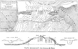
| 111 AD | Lake Sapanca Lake Sapanca Lake Sapanca is a fresh water lake in Turkey, between the Gulf of İzmit and the Adapazarı Meadow. The lake has a catchment area of 251 km², surface area is 45 km², a length 16 km east-west / 5 km north-south, and a maximum depth of 52 m.Lake Sapanca, Turkey... –Sea of Marmara Sea of Marmara The Sea of Marmara , also known as the Sea of Marmora or the Marmara Sea, and in the context of classical antiquity as the Propontis , is the inland sea that connects the Black Sea to the Aegean Sea, thus separating Turkey's Asian and European parts. The Bosphorus strait connects it to the Black... |
Inland to coast | For facilitating transfer of inland produce to seaside; subject of correspondence between governor Pliny the Younger Pliny the Younger Gaius Plinius Caecilius Secundus, born Gaius Caecilius or Gaius Caecilius Cilo , better known as Pliny the Younger, was a lawyer, author, and magistrate of Ancient Rome. Pliny's uncle, Pliny the Elder, helped raise and educate him... and emperor Trajan; would have required to overcome difference in height of 32 m |
|
Sources
- Froriep, Siegfried (1986): "Ein Wasserweg in Bithynien. Bemühungen der Römer, Byzantiner und Osmanen", Antike Welt, 2nd Special Edition, pp. 39–50
- Grewe, Klaus (2008): "Tunnels and Canals", in: Oleson, John PeterJohn Peter OlesonJohn Peter Oleson is a Canadian classical archaeologist and historian of ancient technology. His main interests are the Roman Near East, maritime archaeology , and ancient technology, especially hydraulic technology, water-lifting devices, and Roman concrete construction.- Life :Born in 1946 in...
(ed.): The Oxford Handbook of Engineering and Technology in the Classical World, Oxford University Press, pp. 319–336, ISBN 978-0-19-518731-1 - Moore, Frank Gardner (1950): "Three Canal Projects, Roman and Byzantine", American Journal of ArchaeologyAmerican Journal of ArchaeologyThe American Journal of Archaeology , the peer-reviewed journal of the Archaeological Institute of America, has been published since 1897...
, Vol. 54, No. 2, pp. 97–111 - Schörner, Hadwiga (2000): "Künstliche Schiffahrtskanäle in der Antike. Der sogenannte antike Suez-Kanal", Skyllis, Vol. 3, No. 1, pp. 28–43
- Serban, Marko (2009): "Trajan’s Bridge over the Danube", The International Journal of Nautical Archaeology, Vol. 38, No. 2, pp. 331–342
- Tudor, D. (1974): Les ponts romains du Bas-Danube, Bibliotheca Historica Romaniae Études, Vol. 51, Bucharest: Editura Academiei Republicii Socialiste România, pp. 47–134
- White, K. D. (1984): Greek and Roman Technology, London: Thames and Hudson, pp. 110–112; 227–229, table 6
- Wikander, Charlotte (2000): "Canals", in Wikander, Örjan (ed.): Handbook of Ancient Water Technology, Technology and Change in History, Vol. 2, Leiden: Brill, pp. 321–330, ISBN 90-04-11123-9
Further reading
- Redmount, Carol A. (1995): "The Wadi Tumilat and the 'Canal of the Pharaohs'", Journal of Near Eastern StudiesJournal of Near Eastern StudiesThe Journal of Near Eastern Studies is an academic journal published by the University of Chicago Press, devoted to examination of the ancient and medieval civilisations of the Near East. Appearing in its pages are contributions from scholars of international reputation on archaeology, art,...
, Vol. 54, No. 2, pp. 127–135 - Smith, N.A.F. (1977/78): "Roman Canals", Transactions of the Newcomen Society, Vol. 49, pp. 75–86
External links
- Livius.org: Fossa Drusiana
- Livius.org: Fossa Corbulonis
- Telegraph.co.uk: 'Biggest Canal Ever Built by Romans' Discovered