

Kunyu Wanguo Quantu
Encyclopedia
Kunyu Wanguo Quantu printed in China at the request of the Wanli Emperor
during 1602 by the Italian Catholic
missionary Matteo Ricci
and Chinese collaborators, Mandarin Zhong Wentao and the technical translator, Li Zhizao, is the earliest known Chinese
world map
with the style of European
maps. It has been referred to as the Impossible Black Tulip
of Cartography
, "because of its rarity, importance and exoticism".
The map was crucial in expanding Chinese
knowledge of the world. It was later exported to Japan
and was influential there as well.
 The 1602 Ricci map is a very large, 5 ft (1.52 m) high and 12 ft (3.66 m) wide, xylograph of a pseudocylindrical map projection showing China
at the center of the known world. The 1906 Eckert IV map resembles the display of this Chinese map. It is the first map in Chinese to show the Americas
. The map's mirror image
originally was carved on six large blocks of wood and then printed
in brownish ink on six mulberry paper panels, similar to the making of a folding screen
.
It portrays both North
, South America
, and the Pacific Ocean
with reasonable accuracy. China appropriately is linked to Asia
, India
, and the Middle East
. Europe
, the Mediterranean, and Africa
also are well delineated. Diane Neimann, a trustee of the James Ford Bell Trust, notes that: "There is some distortion, but what's on the map is the result of commerce, trade and exploration, so one has a good sense of what was known then."
Ti Bin Zhang, first secretary for cultural affairs at the Chinese Embassy in Washington, D.C.
, said in 2009: "The map represents the momentous first meeting of East and West" and was the "catalyst for commerce."
 The map includes images and annotations describing different regions of the world. Africa is noted to have the world's highest mountain and longest river. The brief description of North America mentions "humped oxen" or bison
(駝峰牛 tuófēngníu), feral horse
s (野馬, yěmǎ), and a region named Jiānádá (加拿大, Canada
). The map identifies Florida
as Huādì (花地), the "Land of Flowers." Several Central and South American places are named, including Guatemala
(哇的麻剌, Wādemálá), Yucatan
(宇革堂, Yǔgétáng), and Chile
(智里, Zhīlǐ).
The map's cartographer, Matteo Ricci, gave a brief description of the discovery of the Americas. "In olden days, nobody had ever known that there were such places as North and South America or Magellanica (using a name
that early mapmakers gave to a supposed continent including Australia, Antarctica, and Tierra del Fuego
), but a hundred years ago, Europeans came sailing in their ships to parts of the sea coast, and so discovered them."
The Museo della Specola Bologna
has in its collection, displayed on the wall of the Globe Room, original copies of panels 1 and 6 of the six panels comprising the 1602 Ricci map. During restoration and mounting, a central panel—a part of the Doppio Emisfero delle Stelle by the German mathematician and astronomer Johann Adam Schall von Bell
—was inserted between the two sections by mistake.
In 1958, Pasquale D’Elia, sinologist at the University of Rome certified the authenticity of the Chinese maps in this museum’s possession, (see op. cit.) stating that "it is the third edition of a geographical and cartographical work that made Ricci famous throughout China. He had already made a first edition in 1584 at Shiuhing, followed by a second in 1600 at Nanking, and two years later a third in Peking.
In 1938, an exhaustive work by Pasquale d'Elia, edited by the Biblioteca Apostolica Vaticana, was published with comments, notes, and translation of the whole map. The maps carry plentiful instructions for use and detailed illustrations of the instruments that went into their production, as well as explanations regarding conceptions of "systems of the terrestrial and celestial world". There is a long preface by Matteo Ricci in the middle of the map, where it depicts the Pacific Ocean. D’Elia’s translation reads:
The figure of the Nove Cieli (Nine Skies) is printed to the left of the title, illustrated as per sixteenth-century conceptions. The accompanying inscription explains the movement of the planets. The right-hand section (panel 6) has other inscriptions giving general ideas on geography and oceanography. Another inscription records an extract of the Storia dei Mongoli regarding the motions of the Sun.
In the top of the left-hand section (panel 1), there is an explanation of eclipses and the method for measuring the Earth and the Moon. Both sections carry the characteristic Jesuit seal, the IHS
of the Compagnia di Gesù
. At the bottom left, in the Southern Hemisphere
, is the name of the Chinese publisher of the map and the date: one day of the first month of autumn in the year 1602.
The map also incorporates an explanation of parallels and meridians, a proof that the sun is larger than the moon, a table showing the distances of planets from the earth, an explanation of the varying lengths of days and nights, and polar projections of the earth that are unusually consistent with its main map.
priest. Ricci was one of the first Western scholars to live in China and he became a master of Chinese script and the Classical Chinese language. In 1583, Ricci was among the first Jesuits to enter China from Macao. The first Chinese world map was named, Yudi Shanhai Quantu (舆地山海全图), and made in Zhaoqing
in 1584 by Matteo Ricci with Chinese collaborators. Ricci had a small Italian wall map in his possession and created Chinese versions of it at the request of the governor of Zhaoqing at the time, Wang Pan, who wanted the document to serve as a resource for explorers and scholars.
On January 24, 1601, Ricci was the first Jesuit - and one of the first Westerners - to enter the Ming
capital Beijing
, bringing atlases of Europe and the West that were unknown to his hosts. The Chinese had maps of the East that were equally unfamiliar to Western scholars.
In 1602, at the request of the Wanli Emperor
, Ricci collaborated with Mandarin Zhong Wentao, a technical translator, Li Zhizao, and other Chinese scholars in Beijing to create what was his third and largest world map, the Kūnyú Wànguó Quántú (坤輿萬國全圖: "A Map of the Myriad Countries of the World").
In this map, European geographic knowledge, new to the Chinese, was combined with Chinese information unknown to Europeans to create the first map known to combine Chinese and European cartography. Among other things, this map revealed the existence of America to the Chinese. Ford W. Bell said: "This was a great collaboration between East and West. It really is a very clear example of how trade was a driving force behind the spread of civilization."
According to John D. Day, Matteo Ricci prepared four editions of Chinese world maps during his mission in China before 1603:
Wanli Emperor
The Wanli Emperor was emperor of China between 1572 and 1620. His era name means "Ten thousand calendars". Born Zhu Yijun, he was the Longqing Emperor's third son...
during 1602 by the Italian Catholic
Catholic
The word catholic comes from the Greek phrase , meaning "on the whole," "according to the whole" or "in general", and is a combination of the Greek words meaning "about" and meaning "whole"...
missionary Matteo Ricci
Matteo Ricci
Matteo Ricci, SJ was an Italian Jesuit priest, and one of the founding figures of the Jesuit China Mission, as it existed in the 17th-18th centuries. His current title is Servant of God....
and Chinese collaborators, Mandarin Zhong Wentao and the technical translator, Li Zhizao, is the earliest known Chinese
Classical Chinese
Classical Chinese or Literary Chinese is a traditional style of written Chinese based on the grammar and vocabulary of ancient Chinese, making it different from any modern spoken form of Chinese...
world map
World map
A world map is a map of the surface of the Earth, which may be made using any of a number of different map projections. A map projection is any method of representing the surface of a sphere or other three-dimensional body on a plane....
with the style of European
Europe
Europe is, by convention, one of the world's seven continents. Comprising the westernmost peninsula of Eurasia, Europe is generally 'divided' from Asia to its east by the watershed divides of the Ural and Caucasus Mountains, the Ural River, the Caspian and Black Seas, and the waterways connecting...
maps. It has been referred to as the Impossible Black Tulip
Tulip mania
Tulip mania or tulipomania was a period in the Dutch Golden Age during which contract prices for bulbs of the recently introduced tulip reached extraordinarily high levels and then suddenly collapsed...
of Cartography
Cartography
Cartography is the study and practice of making maps. Combining science, aesthetics, and technique, cartography builds on the premise that reality can be modeled in ways that communicate spatial information effectively.The fundamental problems of traditional cartography are to:*Set the map's...
, "because of its rarity, importance and exoticism".
The map was crucial in expanding Chinese
China
Chinese civilization may refer to:* China for more general discussion of the country.* Chinese culture* Greater China, the transnational community of ethnic Chinese.* History of China* Sinosphere, the area historically affected by Chinese culture...
knowledge of the world. It was later exported to Japan
Japan
Japan is an island nation in East Asia. Located in the Pacific Ocean, it lies to the east of the Sea of Japan, China, North Korea, South Korea and Russia, stretching from the Sea of Okhotsk in the north to the East China Sea and Taiwan in the south...
and was influential there as well.
Description
China
Chinese civilization may refer to:* China for more general discussion of the country.* Chinese culture* Greater China, the transnational community of ethnic Chinese.* History of China* Sinosphere, the area historically affected by Chinese culture...
at the center of the known world. The 1906 Eckert IV map resembles the display of this Chinese map. It is the first map in Chinese to show the Americas
Americas
The Americas, or America , are lands in the Western hemisphere, also known as the New World. In English, the plural form the Americas is often used to refer to the landmasses of North America and South America with their associated islands and regions, while the singular form America is primarily...
. The map's mirror image
Mirror image
A mirror image is a reflected duplication of an object that appears identical but reversed. As an optical effect it results from reflection off of substances such as a mirror or water. It is also a concept in geometry and can be used as a conceptualization process for 3-D structures...
originally was carved on six large blocks of wood and then printed
Woodblock printing
Woodblock printing is a technique for printing text, images or patterns used widely throughout East Asia and originating in China in antiquity as a method of printing on textiles and later paper....
in brownish ink on six mulberry paper panels, similar to the making of a folding screen
Folding Screen
A folding screen , is a piece of free-standing furniture which consists of several frames or panels connected by hinges. It can be made in a variety of designs and with different kinds of materials. Screens have many practical and decorative uses...
.
It portrays both North
North America
North America is a continent wholly within the Northern Hemisphere and almost wholly within the Western Hemisphere. It is also considered a northern subcontinent of the Americas...
, South America
South America
South America is a continent situated in the Western Hemisphere, mostly in the Southern Hemisphere, with a relatively small portion in the Northern Hemisphere. The continent is also considered a subcontinent of the Americas. It is bordered on the west by the Pacific Ocean and on the north and east...
, and the Pacific Ocean
Pacific Ocean
The Pacific Ocean is the largest of the Earth's oceanic divisions. It extends from the Arctic in the north to the Southern Ocean in the south, bounded by Asia and Australia in the west, and the Americas in the east.At 165.2 million square kilometres in area, this largest division of the World...
with reasonable accuracy. China appropriately is linked to Asia
Asia
Asia is the world's largest and most populous continent, located primarily in the eastern and northern hemispheres. It covers 8.7% of the Earth's total surface area and with approximately 3.879 billion people, it hosts 60% of the world's current human population...
, India
India
India , officially the Republic of India , is a country in South Asia. It is the seventh-largest country by geographical area, the second-most populous country with over 1.2 billion people, and the most populous democracy in the world...
, and the Middle East
Middle East
The Middle East is a region that encompasses Western Asia and Northern Africa. It is often used as a synonym for Near East, in opposition to Far East...
. Europe
Europe
Europe is, by convention, one of the world's seven continents. Comprising the westernmost peninsula of Eurasia, Europe is generally 'divided' from Asia to its east by the watershed divides of the Ural and Caucasus Mountains, the Ural River, the Caspian and Black Seas, and the waterways connecting...
, the Mediterranean, and Africa
Africa
Africa is the world's second largest and second most populous continent, after Asia. At about 30.2 million km² including adjacent islands, it covers 6% of the Earth's total surface area and 20.4% of the total land area...
also are well delineated. Diane Neimann, a trustee of the James Ford Bell Trust, notes that: "There is some distortion, but what's on the map is the result of commerce, trade and exploration, so one has a good sense of what was known then."
Ti Bin Zhang, first secretary for cultural affairs at the Chinese Embassy in Washington, D.C.
Washington, D.C.
Washington, D.C., formally the District of Columbia and commonly referred to as Washington, "the District", or simply D.C., is the capital of the United States. On July 16, 1790, the United States Congress approved the creation of a permanent national capital as permitted by the U.S. Constitution....
, said in 2009: "The map represents the momentous first meeting of East and West" and was the "catalyst for commerce."
Details
Bison
Members of the genus Bison are large, even-toed ungulates within the subfamily Bovinae. Two extant and four extinct species are recognized...
(駝峰牛 tuófēngníu), feral horse
Feral horse
A feral horse is a free-roaming horse of domesticated ancestry. As such, a feral horse is not a wild animal in the sense of an animal without domesticated ancestors. However, some populations of feral horses are managed as wildlife, and these horses often are popularly called "wild" horses...
s (野馬, yěmǎ), and a region named Jiānádá (加拿大, Canada
Canada
Canada is a North American country consisting of ten provinces and three territories. Located in the northern part of the continent, it extends from the Atlantic Ocean in the east to the Pacific Ocean in the west, and northward into the Arctic Ocean...
). The map identifies Florida
Florida
Florida is a state in the southeastern United States, located on the nation's Atlantic and Gulf coasts. It is bordered to the west by the Gulf of Mexico, to the north by Alabama and Georgia and to the east by the Atlantic Ocean. With a population of 18,801,310 as measured by the 2010 census, it...
as Huādì (花地), the "Land of Flowers." Several Central and South American places are named, including Guatemala
Guatemala
Guatemala is a country in Central America bordered by Mexico to the north and west, the Pacific Ocean to the southwest, Belize to the northeast, the Caribbean to the east, and Honduras and El Salvador to the southeast...
(哇的麻剌, Wādemálá), Yucatan
Yucatán
Yucatán officially Estado Libre y Soberano de Yucatán is one of the 31 states which, with the Federal District, comprise the 32 Federal Entities of Mexico. It is divided in 106 municipalities and its capital city is Mérida....
(宇革堂, Yǔgétáng), and Chile
Chile
Chile ,officially the Republic of Chile , is a country in South America occupying a long, narrow coastal strip between the Andes mountains to the east and the Pacific Ocean to the west. It borders Peru to the north, Bolivia to the northeast, Argentina to the east, and the Drake Passage in the far...
(智里, Zhīlǐ).
The map's cartographer, Matteo Ricci, gave a brief description of the discovery of the Americas. "In olden days, nobody had ever known that there were such places as North and South America or Magellanica (using a name
Terra Australis
Terra Australis, Terra Australis Ignota or Terra Australis Incognita was a hypothesized continent appearing on European maps from the 15th to the 18th century...
that early mapmakers gave to a supposed continent including Australia, Antarctica, and Tierra del Fuego
Tierra del Fuego
Tierra del Fuego is an archipelago off the southernmost tip of the South American mainland, across the Strait of Magellan. The archipelago consists of a main island Isla Grande de Tierra del Fuego divided between Chile and Argentina with an area of , and a group of smaller islands including Cape...
), but a hundred years ago, Europeans came sailing in their ships to parts of the sea coast, and so discovered them."
The Museo della Specola Bologna
Bologna
Bologna is the capital city of Emilia-Romagna, in the Po Valley of Northern Italy. The city lies between the Po River and the Apennine Mountains, more specifically, between the Reno River and the Savena River. Bologna is a lively and cosmopolitan Italian college city, with spectacular history,...
has in its collection, displayed on the wall of the Globe Room, original copies of panels 1 and 6 of the six panels comprising the 1602 Ricci map. During restoration and mounting, a central panel—a part of the Doppio Emisfero delle Stelle by the German mathematician and astronomer Johann Adam Schall von Bell
Johann Adam Schall von Bell
Johann Adam Schall von Bell was a German Jesuit and astronomer. He spent most of his life as a missionary in China and became an adviser to the Chinese emperor.- Life :...
—was inserted between the two sections by mistake.
In 1958, Pasquale D’Elia, sinologist at the University of Rome certified the authenticity of the Chinese maps in this museum’s possession, (see op. cit.) stating that "it is the third edition of a geographical and cartographical work that made Ricci famous throughout China. He had already made a first edition in 1584 at Shiuhing, followed by a second in 1600 at Nanking, and two years later a third in Peking.
In 1938, an exhaustive work by Pasquale d'Elia, edited by the Biblioteca Apostolica Vaticana, was published with comments, notes, and translation of the whole map. The maps carry plentiful instructions for use and detailed illustrations of the instruments that went into their production, as well as explanations regarding conceptions of "systems of the terrestrial and celestial world". There is a long preface by Matteo Ricci in the middle of the map, where it depicts the Pacific Ocean. D’Elia’s translation reads:
The figure of the Nove Cieli (Nine Skies) is printed to the left of the title, illustrated as per sixteenth-century conceptions. The accompanying inscription explains the movement of the planets. The right-hand section (panel 6) has other inscriptions giving general ideas on geography and oceanography. Another inscription records an extract of the Storia dei Mongoli regarding the motions of the Sun.
In the top of the left-hand section (panel 1), there is an explanation of eclipses and the method for measuring the Earth and the Moon. Both sections carry the characteristic Jesuit seal, the IHS
In hoc signo vinces
In hoc signo vinces is a Latin rendering of the Greek phrase "" en touto nika, and means "in this sign you will conquer"....
of the Compagnia di Gesù
Society of Jesus
The Society of Jesus is a Catholic male religious order that follows the teachings of the Catholic Church. The members are called Jesuits, and are also known colloquially as "God's Army" and as "The Company," these being references to founder Ignatius of Loyola's military background and a...
. At the bottom left, in the Southern Hemisphere
Southern Hemisphere
The Southern Hemisphere is the part of Earth that lies south of the equator. The word hemisphere literally means 'half ball' or "half sphere"...
, is the name of the Chinese publisher of the map and the date: one day of the first month of autumn in the year 1602.
The map also incorporates an explanation of parallels and meridians, a proof that the sun is larger than the moon, a table showing the distances of planets from the earth, an explanation of the varying lengths of days and nights, and polar projections of the earth that are unusually consistent with its main map.
History
Matteo Ricci (1552–1610) was a JesuitSociety of Jesus
The Society of Jesus is a Catholic male religious order that follows the teachings of the Catholic Church. The members are called Jesuits, and are also known colloquially as "God's Army" and as "The Company," these being references to founder Ignatius of Loyola's military background and a...
priest. Ricci was one of the first Western scholars to live in China and he became a master of Chinese script and the Classical Chinese language. In 1583, Ricci was among the first Jesuits to enter China from Macao. The first Chinese world map was named, Yudi Shanhai Quantu (舆地山海全图), and made in Zhaoqing
Zhaoqing
Zhaoqing is a prefecture-level city of Guangdong province in southern China.-Geography:Zhaoqing is located 110 km northwest of Guangzhou, in the west Pearl River Delta. It lies on the north shores of the Xijiang River, which is flows from west to east, and opposite of Gaoyao...
in 1584 by Matteo Ricci with Chinese collaborators. Ricci had a small Italian wall map in his possession and created Chinese versions of it at the request of the governor of Zhaoqing at the time, Wang Pan, who wanted the document to serve as a resource for explorers and scholars.
On January 24, 1601, Ricci was the first Jesuit - and one of the first Westerners - to enter the Ming
Ming Dynasty
The Ming Dynasty, also Empire of the Great Ming, was the ruling dynasty of China from 1368 to 1644, following the collapse of the Mongol-led Yuan Dynasty. The Ming, "one of the greatest eras of orderly government and social stability in human history", was the last dynasty in China ruled by ethnic...
capital Beijing
Beijing
Beijing , also known as Peking , is the capital of the People's Republic of China and one of the most populous cities in the world, with a population of 19,612,368 as of 2010. The city is the country's political, cultural, and educational center, and home to the headquarters for most of China's...
, bringing atlases of Europe and the West that were unknown to his hosts. The Chinese had maps of the East that were equally unfamiliar to Western scholars.
In 1602, at the request of the Wanli Emperor
Wanli Emperor
The Wanli Emperor was emperor of China between 1572 and 1620. His era name means "Ten thousand calendars". Born Zhu Yijun, he was the Longqing Emperor's third son...
, Ricci collaborated with Mandarin Zhong Wentao, a technical translator, Li Zhizao, and other Chinese scholars in Beijing to create what was his third and largest world map, the Kūnyú Wànguó Quántú (坤輿萬國全圖: "A Map of the Myriad Countries of the World").
In this map, European geographic knowledge, new to the Chinese, was combined with Chinese information unknown to Europeans to create the first map known to combine Chinese and European cartography. Among other things, this map revealed the existence of America to the Chinese. Ford W. Bell said: "This was a great collaboration between East and West. It really is a very clear example of how trade was a driving force behind the spread of civilization."
According to John D. Day, Matteo Ricci prepared four editions of Chinese world maps during his mission in China before 1603:
- a 1584 early woodblock print made in Zhaoqing, called Yudi Shanhai Quantu (舆地山海全图);
- a 1596 map carved on a steleSteleA stele , also stela , is a stone or wooden slab, generally taller than it is wide, erected for funerals or commemorative purposes, most usually decorated with the names and titles of the deceased or living — inscribed, carved in relief , or painted onto the slab...
, called Shanhai yudi tu (山海輿地圖); - a 1600 revised version of the 1596, usually named Shanhai Yudi Quantu, engraved by Wu Zhongming;
- a 1602 larger and much refined edition of the 1584 map, in six panels, printed in Beijing, called Kūnyú Wànguó Quántú (坤輿萬國全圖);
Several prints of the Kūnyú Wànguó Quántú were made in 1602. Most of the original maps now are lost. Only six original copies of the map are known to exist, and only two are in good condition. Known copies are in the VaticanVatican LibraryThe Vatican Library is the library of the Holy See, currently located in Vatican City. It is one of the oldest libraries in the world and contains one of the most significant collections of historical texts. Formally established in 1475, though in fact much older, it has 75,000 codices from...
Apostolic Library Collection I and at the James Ford Bell Library at the University of Minnesota. The Vatican's 1602 copy was reproduced by Pasquale d’Elia in the beautifully arranged book, Il mappamondo cinese del P Matteo Ricci, S.I. in 1938. This modern work also contains Italian translations of the colophonColophon (publishing)In publishing, a colophon is either:* A brief description of publication or production notes relevant to the edition, in modern books usually located at the reverse of the title page, but can also sometimes be located at the end of the book, or...
s on the map, a catalogue of all toponyms, plus detailed notes regarding their identification.
Other copies of the 1602 map are located at: Japan, Kyoto UniversityKyoto University, or is a national university located in Kyoto, Japan. It is the second oldest Japanese university, and formerly one of Japan's Imperial Universities.- History :...
Collection; collection of Japan Miyagi PrefectureMiyagi Prefectureis a prefecture of Japan in the Tōhoku Region on Honshu island. The capital is Sendai.- History :Miyagi Prefecture was formerly part of the province of Mutsu. Mutsu Province, on northern Honshu, was one of the last provinces to be formed as land was taken from the indigenous Emishi, and became the...
Library; Collection of the Library of the Japanese Cabinet; and a private collection in Paris, France. No original examples of the map are known to exist in China, where Ricci was revered and buried.
The maps received widespread attention and circulation. The governor General of Guizhou reproduced a copy of the map in a book about Guizhou published in Guiyang in 1604. Ricci estimated that more than 1,000 copies of the 1602 edition were reprinted.
Various versions of the map were exported to JapanJapanJapan is an island nation in East Asia. Located in the Pacific Ocean, it lies to the east of the Sea of Japan, China, North Korea, South Korea and Russia, stretching from the Sea of Okhotsk in the north to the East China Sea and Taiwan in the south...
, and later KoreaKoreaKorea ) is an East Asian geographic region that is currently divided into two separate sovereign states — North Korea and South Korea. Located on the Korean Peninsula, Korea is bordered by the People's Republic of China to the northwest, Russia to the northeast, and is separated from Japan to the...
. An unattributed and very detailed two page coloured edition of the map, known in Japanese as Konyo Bankoku Zenzu, was made in Japan circa 1604. Within this Japanese export copy, Japanese KatakanaKatakanais a Japanese syllabary, one component of the Japanese writing system along with hiragana, kanji, and in some cases the Latin alphabet . The word katakana means "fragmentary kana", as the katakana scripts are derived from components of more complex kanji. Each kana represents one mora...
is utilised for foreign location names throughout the Western world.
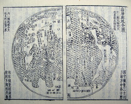
The Gonyeomangukjeondo (HangulHangulHangul,Pronounced or ; Korean: 한글 Hangeul/Han'gŭl or 조선글 Chosŏn'gŭl/Joseongeul the Korean alphabet, is the native alphabet of the Korean language. It is a separate script from Hanja, the logographic Chinese characters which are also sometimes used to write Korean...
: 곤여만국전도) is a KoreaKoreaKorea ) is an East Asian geographic region that is currently divided into two separate sovereign states — North Korea and South Korea. Located on the Korean Peninsula, Korea is bordered by the People's Republic of China to the northwest, Russia to the northeast, and is separated from Japan to the...
n hand-copied reproduction print by Painter Kim Jin-yeo in 1708, the 34th year of King Sukjong'sSukjong of JoseonSukjong was the 19th king of the Joseon Dynasty of Korea from 1674 to 1720.- Biography :King Sukjong was born on 15 August 1661 to King Hyeonjong and Queen Myeongseong at Changdeok Palace. His given name was Yi Sun...
rule of JoseonJoseonJoseon, Chosŏn, Choseon or Chosun are English spellings of the Korean *word for "Korea". It may refer to:*Korea*Gojoseon, the first Korean kingdom, from 2333 BC to 108 BC.*Joseon Dynasty of Korea, from AD 1392 to 1910....
. It shows Kunyu Wanguo Quantu (Complete Map of the World) measuring 533×170 cm on mulberry paper. This map, representing the world in an ellipse, was brought to Korea in the 36th year of King Seonjo's rule (1710) by Lee Gwan-jeong and Gwon Hui, two envoys of Joseon to China. It is owned and displayed at Seoul National UniversitySeoul National UniversitySeoul National University , colloquially known in Korean as Seoul-dae , is a national research university in Seoul, Korea, ranked 24th in the world in publications in an analysis of data from the Science Citation Index, 7th in Asia and 42nd in the world by the 2011 QS World University Rankings...
Museum, San 56-1, Sillim-dong, Gwanak-gu, SeoulSeoulSeoul , officially the Seoul Special City, is the capital and largest metropolis of South Korea. A megacity with a population of over 10 million, it is the largest city proper in the OECD developed world...
, Korea and was designated National Treasure No.849 on August 9, 1985.
The map shows five world continents and over 850 toponyms. It contains descriptions of ethnic groups and main products associated with each region. In the margins outside the ellipse, there are images of the northern and southern hemispheres, the Aristotelian geocentric world system, and the orbits of the sun and moon. It has an introduction by Choe Seok-jeong providing information on the constitution of the map and its production process.
This reproduction map provides a clear testimony to the national interest in western maps in 17th-century Korea, it is a highly esthetic piece of work, and one of the most beautiful maps produced during the Joseon period.
Bell Library copy
The James Ford Bell Trust announced in December 2009 that it had acquired one of two good copies of the 1602 Ricci map from the firm of Bernard J. Shapero, a noted dealer of rare books and maps in London, for US$1 million, the second most expensive map purchase in history. This copy had been held for years by a private collector in Japan.
Ford W. Bell, president of the American Association of MuseumsAmerican Association of MuseumsThe American Association of Museums is a non-profit association that has brought museums together since its founding in 1906, helping develop standards and best practices, gathering and sharing knowledge, and advocating on issues of concern to the museum community...
and a trustee of the James Ford Bell Trust started by his grandfather, James Ford BellJames Ford BellJames Ford Bell was an American business leader and philanthropist who served as president of General Mills from 1928 to 1934 and chairman from 1934 to 1948....
, the founder of General MillsGeneral MillsGeneral Mills, Inc. is an American Fortune 500 corporation, primarily concerned with food products, which is headquartered in Golden Valley, Minnesota, a suburb of Minneapolis. The company markets many well-known brands, such as Betty Crocker, Yoplait, Colombo, Totinos, Jeno's, Pillsbury, Green...
, said in an interview with a reporter from Minnesota Public RadioMinnesota Public RadioMinnesota Public Radio , is the flagship National Public Radio member network for the state of Minnesota. With its three services, News & Information, Classical Music and The Current, MPR operates a 42-station regional radio network in the upper Midwest serving over 8 million people...
's All Things ConsideredAll Things ConsideredAll Things Considered is the flagship news program on the American network National Public Radio. It was the first news program on NPR, and is broadcast live worldwide through several outlets...
: "These opportunities don't present themselves very often. This map was the only one on the market, and the only one likely to be on the market. So we had to take advantage of that opportunity."
The map was displayed for the first time in North America at the Library of CongressLibrary of CongressThe Library of Congress is the research library of the United States Congress, de facto national library of the United States, and the oldest federal cultural institution in the United States. Located in three buildings in Washington, D.C., it is the largest library in the world by shelf space and...
from January through April, 2010. It was scannedImage scannerIn computing, an image scanner—often abbreviated to just scanner—is a device that optically scans images, printed text, handwriting, or an object, and converts it to a digital image. Common examples found in offices are variations of the desktop scanner where the document is placed on a glass...
by the Library of Congress Geography and Map Division to create a permanent digital imageDigital imageA digital image is a numeric representation of a two-dimensional image. Depending on whether or not the image resolution is fixed, it may be of vector or raster type...
that will be posted on the internetInternetThe Internet is a global system of interconnected computer networks that use the standard Internet protocol suite to serve billions of users worldwide...
later in 2010 in the World Digital LibraryWorld Digital LibraryThe World Digital Library is an international digital library operated by UNESCO and the United States Library of Congress.The WDL has stated that its mission is to promote international and intercultural understanding, expand the volume and variety of cultural content on the Internet, provide...
for scholars and students to study. The map was then exhibited briefly at the Minneapolis Institute of ArtsMinneapolis Institute of ArtsThe Minneapolis Institute of Arts is a fine art museum located in the Whittier neighborhood of Minneapolis, Minnesota, on a campus that covers nearly 8 acres , formerly Morrison Park...
, before moving to its permanent home at the James Ford Bell LibraryJames Ford Bell LibraryThe James Ford Bell Library is named for its donor and patron James Ford Bell, the founder of the General Mills Corporation in Minneapolis, Minnesota. The collection consists of some 30,000 rare books, maps, manuscripts, broadsides, pamphlets and other materials documenting the history and impact...
at the University of MinnesotaUniversity of MinnesotaThe University of Minnesota, Twin Cities is a public research university located in Minneapolis and St. Paul, Minnesota, United States. It is the oldest and largest part of the University of Minnesota system and has the fourth-largest main campus student body in the United States, with 52,557...
, where it will be on display beginning September 15, 2010.
Chinese maps published after 1602
Before his death at Peking in 1610, Matteo Ricci prepared four more world maps after the 1602 one:- 5. a 1603 eight panel version of the 1602 map, usually named Liangyi Xuanlan Tu (兩儀玄覽圖) (Map for the far-reaching observation of heaven and earth). The 1603 edition is larger than the 1602, but is less well known because of the fewer extant copies and versions based on it;
- 6. a 1604 booklet based on the map of 1600, also named Shanhai Yudi Quantu; engraved by Guo Zizhang 郭子章;
- 7. a new 1608 version, twelve copies presented to the emperor
- 8. and a 1609 map in two hemispheres.
Most of these maps now are lost. Six copies of the Liangyi Xuanlan Tu (兩儀玄覽圖) made in 1603 may be found in China, Korea, London, and Vienna; one copy of the map recently was discovered in the store-rooms of the Shenyang Museum in China. A world search is currently in progress by Kendall Whaling Museum of Massachusetts. Hong Weilian, earlier established a list of twelve total Ricci maps, which differs considerably from Day’s findings.
In 1607 or 1609 the Shanhai Yudi QuantuShanhai Yudi QuantuThe Shanhai Yudi Quantu is a Chinese map which was published in 1607/1609 in the geographical treatise Sancai Tuhui .- Influences :The Shanhai Yudi Quantu is known to have be highly influenced by the Jesuit missions in China, starting with the work of Matteo Ricci...
, is a Chinese map which was published in the geographical treatise Sancai TuhuiSancai TuhuiThe Sancai Tuhui, compiled by Shanghai natives Wang Qi and Wang Siyi , is a Chinese encyclopedia known at the time as a type of Book by category , completed in 1607 and published in 1609 during the Ming dynasty, featuring illustrations of subjects in the three worlds of heaven, earth, and...
. The Shanhai Yudi Quantu was influenced highly by the work of Matteo RicciMatteo RicciMatteo Ricci, SJ was an Italian Jesuit priest, and one of the founding figures of the Jesuit China Mission, as it existed in the 17th-18th centuries. His current title is Servant of God....
. Matteo Ricci had several of his own maps entitled Shanhai Yudi Quantu. The locations in the map have been identified and translated by Roderich Ptak in his work, The Sino-European Map (“Shanhai yudi quantu”), in the Encyclopedia Sancai tuhui:
About 1620 Giulio Aleni made the world map Wanguo QuantuWanguo QuantuThe Wanguo Quantu is a type of map that was developed by the Jesuits in the 1620s, within the context of the Jesuit China Missions.-Development:...
(萬國全圖, lit. "Complete map of all the countries"), putting China at the center of the world map, following Ricci's format and contents, but in a much smaller size (49 cm x 24 cm). This map was included in some editions of Aleni's geographical work, Zhifang waiji. (Descriptions of Foreign Land) His 1623 preface states that another Jesuit, Diego de PantojaDiego de PantojaDiego de Pantoja or Diego Pantoja, Chinese: 龐迪我, or Pang Diwo 龐迪我 , was a Spanish Jesuit and missionary to China who is best known for having accompanied Matteo Ricci in Beijing. His name also appears in some sources as Didaco Pantoia.He came to Macao on 20 July 1597...
(1571–1618), on the command of the emperor, had translated a different European map, also following Ricci's model, but there is no other knowledge of that work.
In 1633, the Jesuit, Francesco SambiasiFrancesco SambiasiFrancesco Sambiasi or Bi Fangji was a Catholic missionary to China, part of the Jesuits. He was sent with the boat Nossa Senhora da Piedade to the East on 23 March 1609 and arrived in Macao in 1610...
(1582–1649), composed and annotated another world map, entitled Kunyu Quantu (Universal Map of the World), in NanjingNanjing' is the capital of Jiangsu province in China and has a prominent place in Chinese history and culture, having been the capital of China on several occasions...
.
In 1674, Ferdinand VerbiestFerdinand VerbiestFather Ferdinand Verbiest was a Flemish Jesuit missionary in China during the Qing dynasty. He was born in Pittem near Tielt in Flanders, later part of the modern state of Belgium. He is known as Nan Huairen in Chinese...
developed the Kunyu QuantuKunyu QuantuThe Kunyu Quantu , or Full Map of the World, was a map of the world developed by Jesuit father Ferdinand Verbiest during his mission in China in 1674.The map followed the earlier works of Matteo Ricci, such as the Kunyu Wanguo Quantu....
, a similar map, but with various improvements. It consists of eight panels, each 179 cm x 54 cm, together displaying two hemispheres in Mercator projectionMercator projectionThe Mercator projection is a cylindrical map projection presented by the Belgian geographer and cartographer Gerardus Mercator, in 1569. It became the standard map projection for nautical purposes because of its ability to represent lines of constant course, known as rhumb lines or loxodromes, as...
. The two outer scrolls individually depict cartouches that contain several kinds of information on geography and meteorology. The making of Verbiest's Kunyu Quantu was intended to meet the interest of the Kangxi EmperorKangxi EmperorThe Kangxi Emperor ; Manchu: elhe taifin hūwangdi ; Mongolian: Энх-Амгалан хаан, 4 May 1654 –20 December 1722) was the fourth emperor of the Qing Dynasty, the first to be born on Chinese soil south of the Pass and the second Qing emperor to rule over China proper, from 1661 to 1722.Kangxi's...
, as Verbiest's introductory dedication implies. There currently are at least fourteen or fifteen copies and editions of this map known in Europe, Japan, Taiwan, America, and Australia.
Religious significance
Chen, Hui-hung discussed the religious meaning of the world maps that were produced by Jesuit missionaries in China from the late sixteenth to the seventeenth centuries. These world maps serve as a visual proof to emphasize the greatness of the world and the minuscule nature of humans. Through these maps people "can see" the truth of God because of the visual ability granted via God's omnipotence. Jesuit cartography was not only a visual image of geographical configuration: it paved the way for the comprehension of what they expressed as the Creator's significance.
It was an embodiment of the Renaissance tradition of cartography as the graphical representation of the universe. This includes the idea of understanding nature through mathematical science as well as understanding Heaven by visualization and sensibility. In this Renaissance tradition, geography was associated with cosmologyCosmologyCosmology is the discipline that deals with the nature of the Universe as a whole. Cosmologists seek to understand the origin, evolution, structure, and ultimate fate of the Universe at large, as well as the natural laws that keep it in order...
that was based upon Christian theology. These maps expressed Aristotle's sensibility toward comprehension of the universe, which formed the core of Catholic epistemology and natural philosophy. The religious implications of Jesuit cartography in China are part of how the Jesuits used their cartographic superiority strategically in their evangelization.
Ricci was a Jesuit priest whose mission was to convert the Chinese to Roman Catholicism. He thought that might be helped by demonstrating the superior understanding of the world that he believed grew out of Christian faith. The map’s text shows it as part of a diplomatic attempt by Ricci to affirm the greatness of his own religion and culture. Ricci declares that it offers testimony “to the supreme goodness, greatness and unity of Him who controls heaven and earth.”
External links
- Opere Di Matteo Ricci, Il Mappamondo, Zhaoqing 1584, Nanchino 1600, Pechino 1602, 1603, 1608, 1609. a cura di Alfredo Maulo
- Works of Matteo Ricci including descriptions of the six editions of Ricci's world map, by Alfredo Maulo, rough translation from Italian
- Ricci, Matteo, China in the 16th century: the Journals of Matthew Ricci, 1583-1610. Edited by Nicolas Trigault, translated from the Latin by Louis J. Gallagher. New York, Random House, 1953. (English translation of De Christiana expeditione apud SinasDe Christiana expeditione apud SinasDe Christiana expeditione apud Sinas suscepta ab Societate Jesu is a book based on an Italian manuscript written by the most important founding figure of the Jesuit China mission, Matteo Ricci , expanded and translated into Latin by his colleague Nicolas Trigault...
.) - Audio – MPR's Tom Crann talks with Ford W. Bell about Matteo Ricci and the first Chinese world map
- Museo della Specola
- Bernard J. Shapero
- Interview with Ann Waltner about map