

Kilve
Encyclopedia
Kilve is a village in West Somerset
, England, within the Quantock Hills
Area of Outstanding Natural Beauty
, the first AONB to be established, in 1957.
It lies on the A39
almost exactly equidistant from Bridgwater
to the east and Minehead
to the west. The village includes a 17th-century coaching inn, and a post office and stores. This part of the village, formerly known as Putsham, also contains the village hall, which was extended to celebrate the coronation
of Queen Elizabeth II.
of 1086 as Clive, probably meaning cliff.
The parish of Kilve was part of the Williton and Freemanners Hundred.
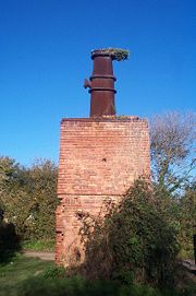 At the far end of the car park are the remains of a red brick retort, built in 1924, when it was discovered that the shale
found in the cliffs was rich in oil. The beach is part of the Blue Anchor to Lilstock Coast SSSI
(Site of Special Scientific Interest
). Along this coast the cliffs are layered with compressed strata of oil-bearing shale and blue, yellow and brown lias embedded with fossils. In 1924 Dr Forbes-Leslie founded the Shaline Company to exploit them. This retort house is thought to be the first structure erected here for the conversion of shale to oil but the company was unable to raise sufficient capital and this is now all that remains of the anticipated Somerset oil boom.
groups on matters of crime, security, and traffic. The parish council's role also includes initiating projects for the maintenance and repair of parish facilities, as well as consulting with the district council on the maintenance, repair, and improvement of highways, drainage, footpaths, public transport, and street cleaning. Conservation matters (including trees and listed buildings) and environmental issues are also the responsibility of the council.
The village falls within the Non-metropolitan district
of West Somerset
, which was formed on April 1, 1974 under the Local Government Act 1972
, having previously been part of Williton Rural District
. The district council are responsible for local planning
and building control, local roads, council housing, environmental health
, market
s and fairs, refuse collection and recycling
, cemeteries and crematoria, leisure services, parks, and tourism
.
Somerset County Council
are responsible for running the largest and most expensive local services such as education
, social services, libraries
, main roads, public transport
, policing
and fire services, trading standards
, waste disposal and strategic planning.
It is also part of the Bridgwater and West Somerset county constituency represented in the House of Commons
of the Parliament of the United Kingdom
. It elects one Member of Parliament (MP)
by the first past the post system of election, and part of the South West England constituency
of the European Parliament
which elects seven MEPs using the d'Hondt method
of party-list proportional representation
.
called Parlo. "But," she writes, "there are local inhabitants who tell of a mythical Frenchman called Pardel and an equally mythical Pardel's Stone stuck somewhere up this lane."
A further settlement lies along the ridge to the east of the village, with a steep and narrow lane running down to join Sea Lane at Meadow House, which was once the Rectory. From half way down this lane there is a panoramic view of the coastline as far as North Hill in Minehead
and across the channel to South Wales
and the Brecon Beacons
. In the foreground lie the Church of St Mary, the ruins of a medieval chantry
and one old barn still standing, though dilapidated, with traditional round stone pillars. Alongside the chantry are two houses and a tea-garden. Lane End was built in traditional cob construction by the distinguished Arts and Crafts
architect Norman Jewson
as a summer house for himself.
A path leads down from the chantry through fields now used as a car-park to the beach which William Wordsworth
, the Romantic
poet, who lived for a brief period with his sister Dorothy
at Alfoxton House
, described as "Kilve's delightful shore". The beach is on the West Somerset Coast Path
.
Kilve Pill, where the stream from Holford
runs into the sea, was once a tiny port, used for importing culm, an inferior type of coal which was used in the limeburning process. It was also the site for "glatting" which was the hunting of conger eel
s by dogs. On the shore a Saint Keyne
serpent can be seen, which a local legend says is a snake turned to stone, but is in reality an ammonite
.
It is just possible to make out the remains of a stone jetty and the ruins of a lime kiln nearby. Here the limestone was burnt to provide farmers with the lime to spread on their fields. The limestone carrier Laurina was wrecked at Kilve in 1876. The Pill was long associated with smuggling and legend has it that barrels of spirits hidden in the chantry were deliberately set fire to as the revenue men appeared on the scene. Legend also has it that the smugglers' ponies were taught to respond to the commands "whoa" and "gee up" in the reverse sense of the words.
Along the whole length of the stream from Holford
to the shore at Kilve there were a number of working mills. Farmers appear to have used water-power in the same way as modern ones use the power from engines. The old mill in the village, now a private house, still retains its overshot wheel, but the others have long since vanished.
and Colin Macfarlane.
The main part of the building was constructed between 1702 and 1705, in the reign of Queen Anne
, by Henry Sweating, and incorporating an earlier dwelling, although alterations were made in the 1920s by Clough Williams-Ellis
. Somerset County Council
acquired the house in 1964 and it was opened in 1965 with residential places for 26 children and four members of staff. Since that date there have been a number of extensions and the house, together with a hutted camp site on the hill above, can now accommodate a total of 166. Kilve Court is a major employer in the village.
as a Grade II* listed building.
Kilve Chantry
was founded in 1329, when a brotherhood of five monks was employed to say Mass for their founder, Simon de Furneaux. The Roll of Incumbents shows that several successive chantry priests were incumbents of Kilve parish. The chantry seems to have fallen into a ruin long before the dissolution of the monasteries
, and for centuries it served as a barn for the adjacent farm. The building stayed in use for many years, possibly by smugglers, until a fire in 1848. It is now listed on English Heritage's Heritage at Risk register as "very bad" with a priority rating of "A", the highest possible.
West Somerset
West Somerset is a local government district in the English county of Somerset. The council covers a largely rural area, with a population of 35,075 in an area of ....
, England, within the Quantock Hills
Quantock Hills
The Quantock Hills is a range of hills west of Bridgwater in Somerset, England. The Quantock Hills were England’s first Area of Outstanding Natural Beauty being designated in 1956 and consists of large amounts of heathland, oak woodlands, ancient parklands and agricultural land.The hills run from...
Area of Outstanding Natural Beauty
Area of Outstanding Natural Beauty
An Area of Outstanding Natural Beauty is an area of countryside considered to have significant landscape value in England, Wales or Northern Ireland, that has been specially designated by the Countryside Agency on behalf of the United Kingdom government; the Countryside Council for Wales on...
, the first AONB to be established, in 1957.
It lies on the A39
A39 road
The A39 is an A road in south west England. It runs south-west from Bath in Somerset through Wells, Glastonbury, Street and Bridgwater. It then follows the north coast of Somerset and Devon through Williton, Minehead, Porlock, Lynmouth, Barnstaple, Bideford, Stratton, Camelford, Wadebridge and St...
almost exactly equidistant from Bridgwater
Bridgwater
Bridgwater is a market town and civil parish in Somerset, England. It is the administrative centre of the Sedgemoor district, and a major industrial centre. Bridgwater is located on the major communication routes through South West England...
to the east and Minehead
Minehead
Minehead is a coastal town and civil parish in Somerset, England. It lies on the south bank of the Bristol Channel, north-west of the county town of Taunton, from the border with the county of Devon and in proximity of the Exmoor National Park...
to the west. The village includes a 17th-century coaching inn, and a post office and stores. This part of the village, formerly known as Putsham, also contains the village hall, which was extended to celebrate the coronation
Coronation of the British monarch
The coronation of the British monarch is a ceremony in which the monarch of the United Kingdom is formally crowned and invested with regalia...
of Queen Elizabeth II.
History
The village was listed in the Domesday BookDomesday Book
Domesday Book , now held at The National Archives, Kew, Richmond upon Thames in South West London, is the record of the great survey of much of England and parts of Wales completed in 1086...
of 1086 as Clive, probably meaning cliff.
The parish of Kilve was part of the Williton and Freemanners Hundred.
Oil extraction
Oil shale
Oil shale, an organic-rich fine-grained sedimentary rock, contains significant amounts of kerogen from which liquid hydrocarbons called shale oil can be produced...
found in the cliffs was rich in oil. The beach is part of the Blue Anchor to Lilstock Coast SSSI
Blue Anchor to Lilstock Coast SSSI
Blue Anchor to Lilstock Coast SSSI is a 742.8 hectare geological Site of Special Scientific Interest between Blue Anchor and Lilstock in Somerset, notified in 1971....
(Site of Special Scientific Interest
Site of Special Scientific Interest
A Site of Special Scientific Interest is a conservation designation denoting a protected area in the United Kingdom. SSSIs are the basic building block of site-based nature conservation legislation and most other legal nature/geological conservation designations in Great Britain are based upon...
). Along this coast the cliffs are layered with compressed strata of oil-bearing shale and blue, yellow and brown lias embedded with fossils. In 1924 Dr Forbes-Leslie founded the Shaline Company to exploit them. This retort house is thought to be the first structure erected here for the conversion of shale to oil but the company was unable to raise sufficient capital and this is now all that remains of the anticipated Somerset oil boom.
Governance
The parish council has responsibility for local issues, including setting an annual precept (local rate) to cover the council’s operating costs and producing annual accounts for public scrutiny. The parish council evaluates local planning applications and works with the local police, district council officers, and neighbourhood watchNeighbourhood Watch (UK)
The Neighbourhood Watch scheme in the United Kingdom is a partnership where people come together to make their communities safer. It involves the Police, Community Safety departments of local authorities, other voluntary organisations and, above all, individuals and families who want to make their...
groups on matters of crime, security, and traffic. The parish council's role also includes initiating projects for the maintenance and repair of parish facilities, as well as consulting with the district council on the maintenance, repair, and improvement of highways, drainage, footpaths, public transport, and street cleaning. Conservation matters (including trees and listed buildings) and environmental issues are also the responsibility of the council.
The village falls within the Non-metropolitan district
Non-metropolitan district
Non-metropolitan districts, or colloquially shire districts, are a type of local government district in England. As created, they are sub-divisions of non-metropolitan counties in a so-called "two-tier" arrangement...
of West Somerset
West Somerset
West Somerset is a local government district in the English county of Somerset. The council covers a largely rural area, with a population of 35,075 in an area of ....
, which was formed on April 1, 1974 under the Local Government Act 1972
Local Government Act 1972
The Local Government Act 1972 is an Act of Parliament in the United Kingdom that reformed local government in England and Wales on 1 April 1974....
, having previously been part of Williton Rural District
Williton Rural District
Williton was a rural district in Somerset, England, from 1894 to 1974.It was created in 1894 under the Local Government Act 1894.In 1974 it was abolished under the Local Government Act 1972 when it became part of West Somerset....
. The district council are responsible for local planning
Planning permission
Planning permission or planning consent is the permission required in the United Kingdom in order to be allowed to build on land, or change the use of land or buildings. Within the UK the occupier of any land or building will need title to that land or building , but will also need "planning...
and building control, local roads, council housing, environmental health
Environmental health
Environmental health is the branch of public health that is concerned with all aspects of the natural and built environment that may affect human health...
, market
Market
A market is one of many varieties of systems, institutions, procedures, social relations and infrastructures whereby parties engage in exchange. While parties may exchange goods and services by barter, most markets rely on sellers offering their goods or services in exchange for money from buyers...
s and fairs, refuse collection and recycling
Recycling
Recycling is processing used materials into new products to prevent waste of potentially useful materials, reduce the consumption of fresh raw materials, reduce energy usage, reduce air pollution and water pollution by reducing the need for "conventional" waste disposal, and lower greenhouse...
, cemeteries and crematoria, leisure services, parks, and tourism
Tourism
Tourism is travel for recreational, leisure or business purposes. The World Tourism Organization defines tourists as people "traveling to and staying in places outside their usual environment for not more than one consecutive year for leisure, business and other purposes".Tourism has become a...
.
Somerset County Council
Somerset County Council
Somerset County Council is the county council of Somerset in the South West of England, an elected local government authority responsible for the most significant local government services in most of the county.-Area covered:...
are responsible for running the largest and most expensive local services such as education
Local Education Authority
A local education authority is a local authority in England and Wales that has responsibility for education within its jurisdiction...
, social services, libraries
Library
In a traditional sense, a library is a large collection of books, and can refer to the place in which the collection is housed. Today, the term can refer to any collection, including digital sources, resources, and services...
, main roads, public transport
Public transport
Public transport is a shared passenger transportation service which is available for use by the general public, as distinct from modes such as taxicab, car pooling or hired buses which are not shared by strangers without private arrangement.Public transport modes include buses, trolleybuses, trams...
, policing
Police
The police is a personification of the state designated to put in practice the enforced law, protect property and reduce civil disorder in civilian matters. Their powers include the legitimized use of force...
and fire services, trading standards
Trading Standards
Trading Standards is the name given to local authority departments in the UK formerly known as Weights and Measures. These departments investigate commercial organisations that carry out trade in unethical ways or outside the scope of the law.-History:...
, waste disposal and strategic planning.
It is also part of the Bridgwater and West Somerset county constituency represented in the House of Commons
British House of Commons
The House of Commons is the lower house of the Parliament of the United Kingdom, which also comprises the Sovereign and the House of Lords . Both Commons and Lords meet in the Palace of Westminster. The Commons is a democratically elected body, consisting of 650 members , who are known as Members...
of the Parliament of the United Kingdom
Parliament of the United Kingdom
The Parliament of the United Kingdom of Great Britain and Northern Ireland is the supreme legislative body in the United Kingdom, British Crown dependencies and British overseas territories, located in London...
. It elects one Member of Parliament (MP)
Member of Parliament
A Member of Parliament is a representative of the voters to a :parliament. In many countries with bicameral parliaments, the term applies specifically to members of the lower house, as upper houses often have a different title, such as senate, and thus also have different titles for its members,...
by the first past the post system of election, and part of the South West England constituency
South West England (European Parliament constituency)
South West England is a constituency of the European Parliament. For 2009 it elects 6 MEPs using the d'Hondt method of party-list proportional representation, reduced from 7 in 2004.-Boundaries:...
of the European Parliament
European Parliament
The European Parliament is the directly elected parliamentary institution of the European Union . Together with the Council of the European Union and the Commission, it exercises the legislative function of the EU and it has been described as one of the most powerful legislatures in the world...
which elects seven MEPs using the d'Hondt method
D'Hondt method
The d'Hondt method is a highest averages method for allocating seats in party-list proportional representation. The method described is named after Belgian mathematician Victor D'Hondt who described it in 1878...
of party-list proportional representation
Party-list proportional representation
Party-list proportional representation systems are a family of voting systems emphasizing proportional representation in elections in which multiple candidates are elected...
.
Geography
The village actually consists of three settlements. One of these is up Pardlestone Lane, which meanders steeply southwards through mossy cottages, and a few more modern bungalows nestle into the hillside. Berta Lawrence, in her book Quantock Country, suggests that the name Pardlestone derives from the old alternative 'Parleston', where a tiny settlement here belonged to a SaxonAnglo-Saxons
Anglo-Saxon is a term used by historians to designate the Germanic tribes who invaded and settled the south and east of Great Britain beginning in the early 5th century AD, and the period from their creation of the English nation to the Norman conquest. The Anglo-Saxon Era denotes the period of...
called Parlo. "But," she writes, "there are local inhabitants who tell of a mythical Frenchman called Pardel and an equally mythical Pardel's Stone stuck somewhere up this lane."
A further settlement lies along the ridge to the east of the village, with a steep and narrow lane running down to join Sea Lane at Meadow House, which was once the Rectory. From half way down this lane there is a panoramic view of the coastline as far as North Hill in Minehead
Minehead
Minehead is a coastal town and civil parish in Somerset, England. It lies on the south bank of the Bristol Channel, north-west of the county town of Taunton, from the border with the county of Devon and in proximity of the Exmoor National Park...
and across the channel to South Wales
Wales
Wales is a country that is part of the United Kingdom and the island of Great Britain, bordered by England to its east and the Atlantic Ocean and Irish Sea to its west. It has a population of three million, and a total area of 20,779 km²...
and the Brecon Beacons
Brecon Beacons
The Brecon Beacons is a mountain range in South Wales. In a narrow sense, the name refers to the range of popular peaks south of Brecon, including South Wales' highest mountain, Pen y Fan, and which together form the central section of the Brecon Beacons National Park...
. In the foreground lie the Church of St Mary, the ruins of a medieval chantry
Chantry
Chantry is the English term for a fund established to pay for a priest to celebrate sung Masses for a specified purpose, generally for the soul of the deceased donor. Chantries were endowed with lands given by donors, the income from which maintained the chantry priest...
and one old barn still standing, though dilapidated, with traditional round stone pillars. Alongside the chantry are two houses and a tea-garden. Lane End was built in traditional cob construction by the distinguished Arts and Crafts
Arts and Crafts movement
Arts and Crafts was an international design philosophy that originated in England and flourished between 1860 and 1910 , continuing its influence until the 1930s...
architect Norman Jewson
Norman Jewson
Norman Jewson was an English architect-craftsman of the Arts and Crafts movement, who practiced in the Cotswolds. He was a distinguished, younger member of the group which had settled in Sapperton, Gloucestershire, a feudal village in rural southwest England, under the influence of Ernest Gimson...
as a summer house for himself.
A path leads down from the chantry through fields now used as a car-park to the beach which William Wordsworth
William Wordsworth
William Wordsworth was a major English Romantic poet who, with Samuel Taylor Coleridge, helped to launch the Romantic Age in English literature with the 1798 joint publication Lyrical Ballads....
, the Romantic
Romanticism
Romanticism was an artistic, literary and intellectual movement that originated in the second half of the 18th century in Europe, and gained strength in reaction to the Industrial Revolution...
poet, who lived for a brief period with his sister Dorothy
Dorothy Wordsworth
Dorothy Mae Ann Wordsworth was an English author, poet and diarist. She was the sister of the Romantic poet William Wordsworth, and the two were close for all of their lives...
at Alfoxton House
Alfoxton House
Alfoxton House, also known as Alfoxton Park, was built as an 18th century country house in Holford, Somerset, England, within the Quantock Hills Area of Outstanding Natural Beauty...
, described as "Kilve's delightful shore". The beach is on the West Somerset Coast Path
West Somerset Coast Path
The West Somerset Coast Path is a long-distance footpath that links the northern end of the South West Coast Path to the River Parrett Trail.It runs from the hamlet of Steart on the Steart Peninsula, and passes through the villages of Kilve, West Quantoxhead, Williton, Watchet, Blue Anchor, and...
.
Kilve Pill, where the stream from Holford
Holford
Holford is a village and civil parish in West Somerset within the Quantock Hills Area of Outstanding Natural Beauty, and about west of Bridgwater and east of Williton. The village has a population of about 200. The village is on the Quantock Greenway and Coleridge Way footpaths...
runs into the sea, was once a tiny port, used for importing culm, an inferior type of coal which was used in the limeburning process. It was also the site for "glatting" which was the hunting of conger eel
European conger
The European conger, Conger conger, is a conger of the family Congridae, found in the eastern Atlantic from Norway and Iceland to Senegal, and also in the Mediterranean and Black Sea. It is sometimes seen in very shallow water by the shore but can also go down to depths of 1170 m...
s by dogs. On the shore a Saint Keyne
Saint Keyne
Saint Keyne or Cain was a late 5th century holy woman in the West Country, between Liskeard and Looe in SE Cornwall. She is not mentioned as being a saint in the official Catholic encyclopaedia - newadvent.org, so perhaps it's disputable if she is indeed a Catholic saint...
serpent can be seen, which a local legend says is a snake turned to stone, but is in reality an ammonite
Ammonite
Ammonite, as a zoological or paleontological term, refers to any member of the Ammonoidea an extinct subclass within the Molluscan class Cephalopoda which are more closely related to living coleoids Ammonite, as a zoological or paleontological term, refers to any member of the Ammonoidea an extinct...
.
It is just possible to make out the remains of a stone jetty and the ruins of a lime kiln nearby. Here the limestone was burnt to provide farmers with the lime to spread on their fields. The limestone carrier Laurina was wrecked at Kilve in 1876. The Pill was long associated with smuggling and legend has it that barrels of spirits hidden in the chantry were deliberately set fire to as the revenue men appeared on the scene. Legend also has it that the smugglers' ponies were taught to respond to the commands "whoa" and "gee up" in the reverse sense of the words.
Along the whole length of the stream from Holford
Holford
Holford is a village and civil parish in West Somerset within the Quantock Hills Area of Outstanding Natural Beauty, and about west of Bridgwater and east of Williton. The village has a population of about 200. The village is on the Quantock Greenway and Coleridge Way footpaths...
to the shore at Kilve there were a number of working mills. Farmers appear to have used water-power in the same way as modern ones use the power from engines. The old mill in the village, now a private house, still retains its overshot wheel, but the others have long since vanished.
Kilve Court
South of the village is Kilve Court Residential Youth Centre, which runs a wide range of courses for young people including Activity Courses set in the centre's extensive grounds and Enrichment Courses, designed to help gifted and talented children to develop their skills in subjects such as Art, Drama, English and Maths. Kilve Court is one of the few centres in the country to run instructive Creative Writing for ages up to and including 16, primarily directed by writers Beth WebbBeth Webb
Beth Webb is a British children's author. Her books include the popular Fleabag Trilogy and her novel for young adults Star Dancer, published by Macmillan Publishers....
and Colin Macfarlane.
The main part of the building was constructed between 1702 and 1705, in the reign of Queen Anne
Anne of Great Britain
Anne ascended the thrones of England, Scotland and Ireland on 8 March 1702. On 1 May 1707, under the Act of Union, two of her realms, England and Scotland, were united as a single sovereign state, the Kingdom of Great Britain.Anne's Catholic father, James II and VII, was deposed during the...
, by Henry Sweating, and incorporating an earlier dwelling, although alterations were made in the 1920s by Clough Williams-Ellis
Clough Williams-Ellis
Sir Bertram Clough Williams-Ellis, CBE, MC was an English-born Welsh architect known chiefly as creator of the Italianate village of Portmeirion in North Wales.-Origins, education and early career:...
. Somerset County Council
Somerset County Council
Somerset County Council is the county council of Somerset in the South West of England, an elected local government authority responsible for the most significant local government services in most of the county.-Area covered:...
acquired the house in 1964 and it was opened in 1965 with residential places for 26 children and four members of staff. Since that date there have been a number of extensions and the house, together with a hutted camp site on the hill above, can now accommodate a total of 166. Kilve Court is a major employer in the village.
Religious sites
The Church of St Mary dates back to the 14th century. In the vestry is one remaining carved arch of the ancient screen. The tower has recently had a considerable amount of restorative work done on it, and is now rendered and painted a shade of off-white, as the whole church was until the early years of the 20th century. It has been designated by English HeritageEnglish Heritage
English Heritage . is an executive non-departmental public body of the British Government sponsored by the Department for Culture, Media and Sport...
as a Grade II* listed building.
Kilve Chantry
Kilve Chantry
Kilve Chantry was a religious site in Kilve, Somerset, England.The Chantry was founded in 1329, when a brotherhood of five monks was employed to say Mass for their founder, Simon de Furneaux. The Roll of Incumbents shows that several successive chantry priests were incumbents of Kilve parish. It...
was founded in 1329, when a brotherhood of five monks was employed to say Mass for their founder, Simon de Furneaux. The Roll of Incumbents shows that several successive chantry priests were incumbents of Kilve parish. The chantry seems to have fallen into a ruin long before the dissolution of the monasteries
Dissolution of the Monasteries
The Dissolution of the Monasteries, sometimes referred to as the Suppression of the Monasteries, was the set of administrative and legal processes between 1536 and 1541 by which Henry VIII disbanded monasteries, priories, convents and friaries in England, Wales and Ireland; appropriated their...
, and for centuries it served as a barn for the adjacent farm. The building stayed in use for many years, possibly by smugglers, until a fire in 1848. It is now listed on English Heritage's Heritage at Risk register as "very bad" with a priority rating of "A", the highest possible.