
.gif)
Hurricane Debby (2000)
Encyclopedia
Hurricane Debby was a minimal Category 1
hurricane
that formed in mid-to-late August of the year 2000. Debby formed east of the Windward Islands
on August 19, 2000, becoming the seventh tropical cyclone of the 2000 Atlantic hurricane season
. The storm strengthened to a hurricane the next day, becoming the fourth named storm and second hurricane of the year. Afterwards, it moved west, passing over the Leeward Islands
, and just north of Puerto Rico
and Hispaniola
. Debby remained somewhat disorganized for the rest of its lifespan, and dissipated off the southern coast of Cuba
on the 24th.
In Barbuda
, Debby caused moderate roof damage; throughout the Lesser Antilles
, gusty winds damaged fruit trees and power lines. In the United States Virgin Islands
, damage estimates added up to $200,000 (2000 USD). Debby also dropped up to 12 inches (30.5 cm) of rain across Puerto Rico, causing mudslides and damaging bridges and roads. 406 homes were affected from the flooding, with damage totaling to $501,000 (2000 USD), primarily in the municipality of Caguas. Also on the island, the storm was indirectly responsible for one death. On the northern coast of the Dominican Republic
, waves and rainfall caused light to moderate damage; in Cuba, the remnants of Debby helped relieve a severe drought
.
that emerged from the coast of Africa
on August 16, 2000, and entered the Atlantic Ocean
. By the following day, a large and disjointed area of low pressure had formed in the vicinity of the wave; however, contrary to what would be expected of a tropical cyclone, the associated thunderstorm activity was not organized in curved banding features, indicating the storm was still in its early developmental stages. At 0000 UTC on August 18, the National Hurricane Center
identified a low-level circulation center accompanying the system, but it remained weak. A still-broad disturbance continuing westward at around 17 miles per hour (27.4 km/h), its convection began to take on a curved pattern, and on August 19 became situated around a distinct center of low pressure. In light of the improvements in the storm's structure, it was recognized as a tropical depression that same day while located roughly 1000 miles (1,609.3 km) west of the Windward Islands
. With little vertical wind shear
to hinder the depression's progress and developing anticyclonic outflow aloft, the cyclone attained tropical storm status at 0600 UTC on August 20 and received the name Debby.
Tropical Storm Debby quickly strengthened to a Category 1 hurricane
the following day. However, the hurricane-force winds were very concentrated, extending only 25 miles (40 km) from the storm's center of circulation. Debby reached a peak intensity of 85 mph (135 km/h) according to the analysis following the hurricane season, but it had a minimum central pressure
of only 1004 mbar
(hPa) at this point. After weakening slightly, Debby reached its lowest recorded pressure of 991 mbar (hPa), but packed winds of only 80 mph (130 km/h).
Debby remained a somewhat-disorganized hurricane for the rest of its life. It moved west, passing over Barbuda
early on August 22 with 75 mph (120 km/h) winds, and struck St. Barthelemy and Virgin Gorda
as a minimal hurricane shortly after. From there, it moved west, just north of the islands of Puerto Rico
and Hispaniola
. While passing just miles north of Hispaniola's coastline, vertical wind shear and mountainous conditions weakened the tropical cyclone to a tropical storm. Debby began moving west-southwest and lost its closed circulation off the southeastern coast of Cuba
on August 24. The remnants of Debby became a strong tropical wave that continued moving west towards the Yucatán Peninsula
. The remnant low curved northeast and brought strong winds to Cuba and Florida in the subsequent days.
 Several storm warnings were issued for the Caribbean islands to warn their residents of the upcoming storm. In Philipsburg, St. Maarten
, several shops in the downtown area were boarded up to prepare for Debby's approach. Elsewhere along the range of the cyclone's predicted path, homes and businesses were boarded up, and families buried emergency supplies in the ground. Ten U.S. Naval
ships and two submarine
s off the Coast of Vieques Island temporarily abandoned their training exercises and moved over three hundred miles to the south of Puerto Rico, out of the storm predicted path. On Antigua
, electricity was shut down to prevent storm damage to the island's infrastructure. When the hurricane moved into the coastal waters of the U.S. Virgin Islands, the Hovensa oil refinery in St. Croix was shut down, and as a result gas prices rose.
Around 7,000 people in Cuba were evacuated to avoid the oncoming hurricane. Several shelters across the northern Caribbean were open to people, but few people took refuge there. Over Forty shelters were ready for use in Nassau, Bahamas
, even though Debby never affected the island. A total of 889 people in the northern coastal plains were evacuated and placed in shelters out of Debby path. Three shelters were opened for the coming of Debby in St. Thomas
, and another two in St. John
. The total number of people in all five shelters only reached 64. An additional 17 people took refuge in an unknown number of shelters on St. Croix.
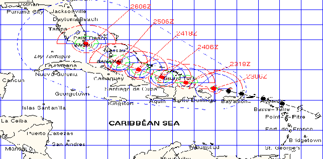
Florida
declared a state of emergency for the Florida Keys
, even though the hurricane was still far from Florida Non-residents in Monroe County
were forced to leave, causing a significant reduction in the tourism for that year. For a period of time, forecasters predicted Debby to approached the Florida Keys was for the storm to be a Category Two
Hurricane, while the Geophysical Fluid Dynamics Laboratory
predicted a much more intense Debby near the Florida Keys as a Category 4 hurricane with a minimum central pressure of 926 mbar (hPa).
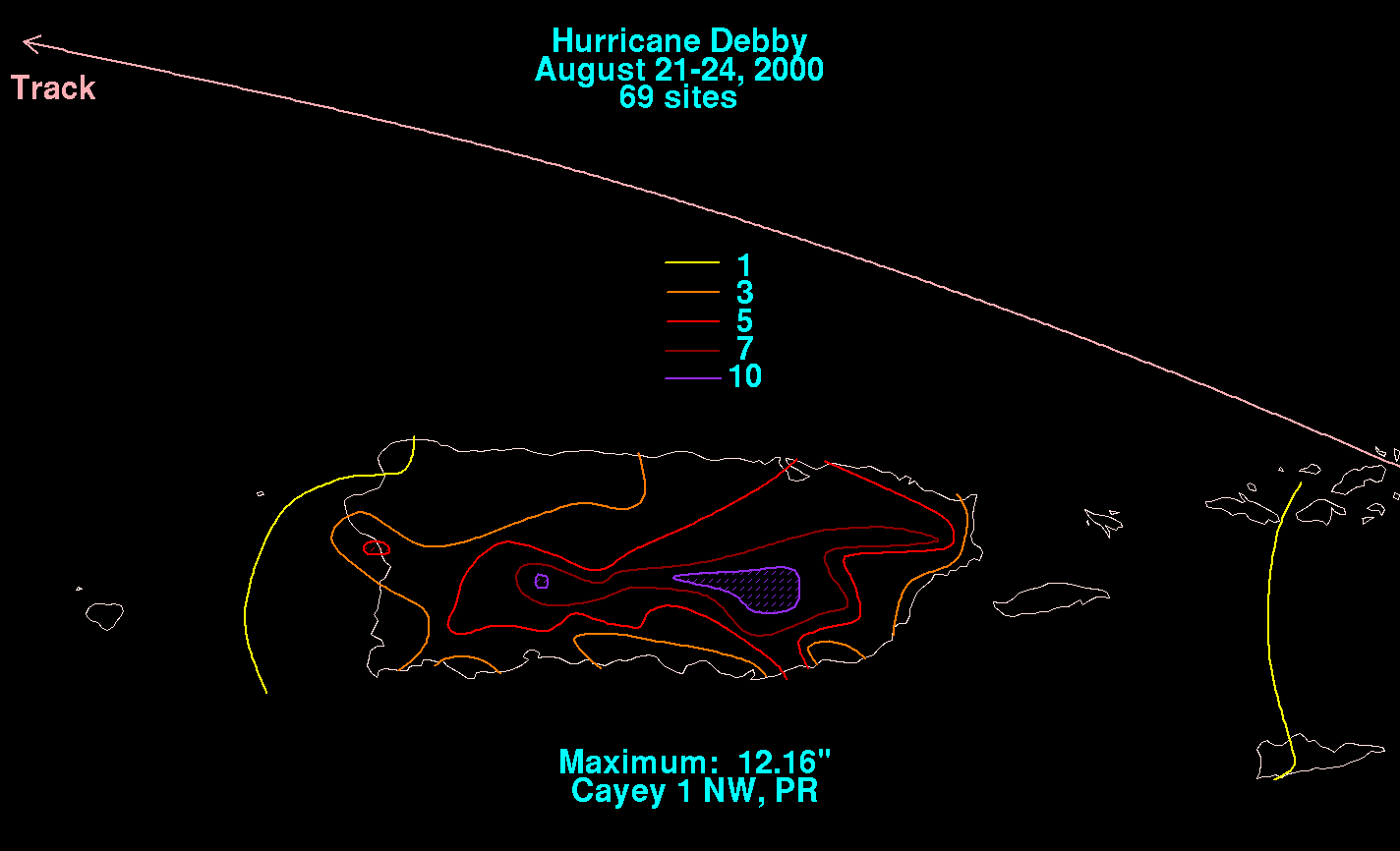
) in damages. Rainfall totals reached as high as one foot in Puerto Rico, and lesser amounts were recorded in other areas along the hurricane's path.
. In Antigua
, downed utility poles and trees were spotted. Rainfall totals in the region were at 0.91 inches (23 mm). St. Martin reported little rainfall as the storm almost uneventfully passed over the island. The only damage reported from St. Martin was some minor flooding and some plant and tree damage. St. Thomas
officially received 1.93 inches (49 mm) of rain. Away from the storm in the southernmost end of the Antilles, Trinidad and Tobago
had a feeder band develop over the country which resulted in flooding in the Barrackpore
region.
 In the United States Virgin Islands
, damaged totals were at $200,000 (2000 USD). Other than that, damage was mostly from brief power blackouts. On St. Thomas, one sailboat was washed ashore on Vessup Beach and minor landscape damage occurred on St. John. 0.46 inches (11.7 mm) of rain fell in St. Croix.
Debby also dropped up to 12 inches (30.5 cm) of rainfall across Puerto Rico in less than 48 hours, causing mudslides and damage to bridges and roads. But most of the island territory only received 3 inches (7.62 mm) of rain. The maximum rainfall on the island was 12.63 inches (32 cm) in Río Piedras, Puerto Rico
. Another measurement of rain that was nearly as high as that was 12.16 inches (31 cm) near Cayey
, though there were unofficial reports of 17 inches (43 cm) of rain in the interior mountains. Because of these heavy rains, several mudslides were reported inland. The hurricane dropped around 5 inches (127 mm) of rain in San Juan
, producing slick roads that resulted in several minor car accidents. 406 homes were affected from the flooding, with damage totaling to $501,000 (2000 USD), primarily in the Caguas municipality. Five houses were moderately to severely damaged; three of which were wooden and the other two being constructed out of concrete. The storm was also indirectly responsible for the death of a 78-year-old man who fell to his death while trying to remove a satellite dish from the roof of his home.
 On the northern coast of the Dominican Republic
, waves and rainfall caused light to moderate damage. Twenty some homes in various places across the northern coast of the country were swept out to sea. At San José de Matanzas, several coconut trees were uprooted from the ground. Also, two houses were slightly damaged from wind gusts. In the nearby town of La Vega
, bridges over the Piedra River and Jumunucu River collapsed due to the heavy rainfall and flooding. Another town, Salcedo
, lost approximately 60 km² (15,000 acres (61 km²)) of banana
s, with the damage costs at $34,000 (2000 USD) or RD$500,000 (2000 DOP
). The country's Civil Defense Force stated that over 700 people on the northern coast were forced out of their homes after severe flooding. Whether or not the people were returned to their homes is unknown.
, Haiti
, encountered some outer rain bands that tore away many tin roofs from the numerous shanties
and flooded some homes. A small coastal village, Carenage, experienced high winds that sunk at least five boats. Storm surge
also swept away one home, but without any reports of injury or death. In Cuba, the remnants of Debby helped relieve a severe drought
. An 8-month-long drought was afflicting Guantanamo
, Cuba, until Debby brought heavy rainfall to the area, putting the widespread thirst to rest. This pleased the local Cubans. Shortly after the storm had dissipated and moved on westward, nearly all of 30,000 or so people displaced because of Debby returned to their homes in Cuba. Heavy rain from Debby's remnants was also dropped on Jamaica
.
Saffir-Simpson Hurricane Scale
The Saffir–Simpson Hurricane Scale , or the Saffir–Simpson Hurricane Wind Scale , classifies hurricanes — Western Hemisphere tropical cyclones that exceed the intensities of tropical depressions and tropical storms — into five categories distinguished by the intensities of their sustained winds...
hurricane
Tropical cyclone
A tropical cyclone is a storm system characterized by a large low-pressure center and numerous thunderstorms that produce strong winds and heavy rain. Tropical cyclones strengthen when water evaporated from the ocean is released as the saturated air rises, resulting in condensation of water vapor...
that formed in mid-to-late August of the year 2000. Debby formed east of the Windward Islands
Windward Islands
The Windward Islands are the southern islands of the Lesser Antilles, within the West Indies.-Name and geography:The Windward Islands are called such because they were more windward to sailing ships arriving in the New World than the Leeward Islands, given that the prevailing trade winds in the...
on August 19, 2000, becoming the seventh tropical cyclone of the 2000 Atlantic hurricane season
2000 Atlantic hurricane season
The 2000 Atlantic hurricane season was the first season without a tropical cyclone in July since 1987. The season officially began on June 1, 2000, and lasted until November 30, 2000. The June through November dates conventionally delimit the period of each year when most tropical cyclones form in...
. The storm strengthened to a hurricane the next day, becoming the fourth named storm and second hurricane of the year. Afterwards, it moved west, passing over the Leeward Islands
Leeward Islands
The Leeward Islands are a group of islands in the West Indies. They are the northern islands of the Lesser Antilles chain. As a group they start east of Puerto Rico and reach southward to Dominica. They are situated where the northeastern Caribbean Sea meets the western Atlantic Ocean...
, and just north of Puerto Rico
Puerto Rico
Puerto Rico , officially the Commonwealth of Puerto Rico , is an unincorporated territory of the United States, located in the northeastern Caribbean, east of the Dominican Republic and west of both the United States Virgin Islands and the British Virgin Islands.Puerto Rico comprises an...
and Hispaniola
Hispaniola
Hispaniola is a major island in the Caribbean, containing the two sovereign states of the Dominican Republic and Haiti. The island is located between the islands of Cuba to the west and Puerto Rico to the east, within the hurricane belt...
. Debby remained somewhat disorganized for the rest of its lifespan, and dissipated off the southern coast of Cuba
Cuba
The Republic of Cuba is an island nation in the Caribbean. The nation of Cuba consists of the main island of Cuba, the Isla de la Juventud, and several archipelagos. Havana is the largest city in Cuba and the country's capital. Santiago de Cuba is the second largest city...
on the 24th.
In Barbuda
Barbuda
Barbuda is an island in the Eastern Caribbean, and forms part of the state of Antigua and Barbuda. It has a population of about 1,500, most of whom live in the town of Codrington.-Location:...
, Debby caused moderate roof damage; throughout the Lesser Antilles
Lesser Antilles
The Lesser Antilles are a long, partly volcanic island arc in the Western Hemisphere. Most of its islands form the eastern boundary of the Caribbean Sea with the Atlantic Ocean, with the remainder located in the southern Caribbean just north of South America...
, gusty winds damaged fruit trees and power lines. In the United States Virgin Islands
United States Virgin Islands
The Virgin Islands of the United States are a group of islands in the Caribbean that are an insular area of the United States. The islands are geographically part of the Virgin Islands archipelago and are located in the Leeward Islands of the Lesser Antilles.The U.S...
, damage estimates added up to $200,000 (2000 USD). Debby also dropped up to 12 inches (30.5 cm) of rain across Puerto Rico, causing mudslides and damaging bridges and roads. 406 homes were affected from the flooding, with damage totaling to $501,000 (2000 USD), primarily in the municipality of Caguas. Also on the island, the storm was indirectly responsible for one death. On the northern coast of the Dominican Republic
Dominican Republic
The Dominican Republic is a nation on the island of La Hispaniola, part of the Greater Antilles archipelago in the Caribbean region. The western third of the island is occupied by the nation of Haiti, making Hispaniola one of two Caribbean islands that are shared by two countries...
, waves and rainfall caused light to moderate damage; in Cuba, the remnants of Debby helped relieve a severe drought
Drought
A drought is an extended period of months or years when a region notes a deficiency in its water supply. Generally, this occurs when a region receives consistently below average precipitation. It can have a substantial impact on the ecosystem and agriculture of the affected region...
.
Meteorological history
The origins of Hurricane Debby trace back to an tropical waveTropical wave
Tropical waves, easterly waves, or tropical easterly waves, also known as African easterly waves in the Atlantic region, are a type of atmospheric trough, an elongated area of relatively low air pressure, oriented north to south, which move from east to west across the tropics causing areas of...
that emerged from the coast of Africa
Africa
Africa is the world's second largest and second most populous continent, after Asia. At about 30.2 million km² including adjacent islands, it covers 6% of the Earth's total surface area and 20.4% of the total land area...
on August 16, 2000, and entered the Atlantic Ocean
Atlantic Ocean
The Atlantic Ocean is the second-largest of the world's oceanic divisions. With a total area of about , it covers approximately 20% of the Earth's surface and about 26% of its water surface area...
. By the following day, a large and disjointed area of low pressure had formed in the vicinity of the wave; however, contrary to what would be expected of a tropical cyclone, the associated thunderstorm activity was not organized in curved banding features, indicating the storm was still in its early developmental stages. At 0000 UTC on August 18, the National Hurricane Center
National Hurricane Center
The National Hurricane Center , located at Florida International University in Miami, Florida, is the division of the National Weather Service responsible for tracking and predicting weather systems within the tropics between the Prime Meridian and the 140th meridian west poleward to the 30th...
identified a low-level circulation center accompanying the system, but it remained weak. A still-broad disturbance continuing westward at around 17 miles per hour (27.4 km/h), its convection began to take on a curved pattern, and on August 19 became situated around a distinct center of low pressure. In light of the improvements in the storm's structure, it was recognized as a tropical depression that same day while located roughly 1000 miles (1,609.3 km) west of the Windward Islands
Windward Islands
The Windward Islands are the southern islands of the Lesser Antilles, within the West Indies.-Name and geography:The Windward Islands are called such because they were more windward to sailing ships arriving in the New World than the Leeward Islands, given that the prevailing trade winds in the...
. With little vertical wind shear
Wind shear
Wind shear, sometimes referred to as windshear or wind gradient, is a difference in wind speed and direction over a relatively short distance in the atmosphere...
to hinder the depression's progress and developing anticyclonic outflow aloft, the cyclone attained tropical storm status at 0600 UTC on August 20 and received the name Debby.
Tropical Storm Debby quickly strengthened to a Category 1 hurricane
Saffir-Simpson Hurricane Scale
The Saffir–Simpson Hurricane Scale , or the Saffir–Simpson Hurricane Wind Scale , classifies hurricanes — Western Hemisphere tropical cyclones that exceed the intensities of tropical depressions and tropical storms — into five categories distinguished by the intensities of their sustained winds...
the following day. However, the hurricane-force winds were very concentrated, extending only 25 miles (40 km) from the storm's center of circulation. Debby reached a peak intensity of 85 mph (135 km/h) according to the analysis following the hurricane season, but it had a minimum central pressure
Atmospheric pressure
Atmospheric pressure is the force per unit area exerted into a surface by the weight of air above that surface in the atmosphere of Earth . In most circumstances atmospheric pressure is closely approximated by the hydrostatic pressure caused by the weight of air above the measurement point...
of only 1004 mbar
Bar (unit)
The bar is a unit of pressure equal to 100 kilopascals, and roughly equal to the atmospheric pressure on Earth at sea level. Other units derived from the bar are the megabar , kilobar , decibar , centibar , and millibar...
(hPa) at this point. After weakening slightly, Debby reached its lowest recorded pressure of 991 mbar (hPa), but packed winds of only 80 mph (130 km/h).
Debby remained a somewhat-disorganized hurricane for the rest of its life. It moved west, passing over Barbuda
Barbuda
Barbuda is an island in the Eastern Caribbean, and forms part of the state of Antigua and Barbuda. It has a population of about 1,500, most of whom live in the town of Codrington.-Location:...
early on August 22 with 75 mph (120 km/h) winds, and struck St. Barthelemy and Virgin Gorda
Virgin Gorda
Virgin Gorda is the third-largest and second most populous of the British Virgin Islands . Located at approximately 18 degrees, 48 minutes North, and 64 degrees, 30 minutes West, it covers an area of about...
as a minimal hurricane shortly after. From there, it moved west, just north of the islands of Puerto Rico
Puerto Rico
Puerto Rico , officially the Commonwealth of Puerto Rico , is an unincorporated territory of the United States, located in the northeastern Caribbean, east of the Dominican Republic and west of both the United States Virgin Islands and the British Virgin Islands.Puerto Rico comprises an...
and Hispaniola
Hispaniola
Hispaniola is a major island in the Caribbean, containing the two sovereign states of the Dominican Republic and Haiti. The island is located between the islands of Cuba to the west and Puerto Rico to the east, within the hurricane belt...
. While passing just miles north of Hispaniola's coastline, vertical wind shear and mountainous conditions weakened the tropical cyclone to a tropical storm. Debby began moving west-southwest and lost its closed circulation off the southeastern coast of Cuba
Cuba
The Republic of Cuba is an island nation in the Caribbean. The nation of Cuba consists of the main island of Cuba, the Isla de la Juventud, and several archipelagos. Havana is the largest city in Cuba and the country's capital. Santiago de Cuba is the second largest city...
on August 24. The remnants of Debby became a strong tropical wave that continued moving west towards the Yucatán Peninsula
Yucatán Peninsula
The Yucatán Peninsula, in southeastern Mexico, separates the Caribbean Sea from the Gulf of Mexico, with the northern coastline on the Yucatán Channel...
. The remnant low curved northeast and brought strong winds to Cuba and Florida in the subsequent days.
Preparations
Philipsburg, Netherlands Antilles
Philipsburg is the main town and capital of the country of Sint Maarten, on a narrow stretch of land between Great Bay and the Great Salt Pond. It functions as the commercial center of Saint Martin island, whereof Sint Maarten encompasses the southern half...
, several shops in the downtown area were boarded up to prepare for Debby's approach. Elsewhere along the range of the cyclone's predicted path, homes and businesses were boarded up, and families buried emergency supplies in the ground. Ten U.S. Naval
United States Navy
The United States Navy is the naval warfare service branch of the United States Armed Forces and one of the seven uniformed services of the United States. The U.S. Navy is the largest in the world; its battle fleet tonnage is greater than that of the next 13 largest navies combined. The U.S...
ships and two submarine
Submarine
A submarine is a watercraft capable of independent operation below the surface of the water. It differs from a submersible, which has more limited underwater capability...
s off the Coast of Vieques Island temporarily abandoned their training exercises and moved over three hundred miles to the south of Puerto Rico, out of the storm predicted path. On Antigua
Antigua
Antigua , also known as Waladli, is an island in the West Indies, in the Leeward Islands in the Caribbean region, the main island of the country of Antigua and Barbuda. Antigua means "ancient" in Spanish and was named by Christopher Columbus after an icon in Seville Cathedral, Santa Maria de la...
, electricity was shut down to prevent storm damage to the island's infrastructure. When the hurricane moved into the coastal waters of the U.S. Virgin Islands, the Hovensa oil refinery in St. Croix was shut down, and as a result gas prices rose.
Around 7,000 people in Cuba were evacuated to avoid the oncoming hurricane. Several shelters across the northern Caribbean were open to people, but few people took refuge there. Over Forty shelters were ready for use in Nassau, Bahamas
Nassau, Bahamas
Nassau is the capital, largest city, and commercial centre of the Commonwealth of the Bahamas. The city has a population of 248,948 , 70 percent of the entire population of The Bahamas...
, even though Debby never affected the island. A total of 889 people in the northern coastal plains were evacuated and placed in shelters out of Debby path. Three shelters were opened for the coming of Debby in St. Thomas
Saint Thomas, U.S. Virgin Islands
Saint Thomas is an island in the Caribbean Sea and with the islands of Saint John, Saint Croix, and Water Island a county and constituent district of the United States Virgin Islands , an unincorporated territory of the United States. Located on the island is the territorial capital and port of...
, and another two in St. John
Saint John, U.S. Virgin Islands
Saint John is an island in the Caribbean Sea and a constituent district of the United States Virgin Islands , an unincorporated territory of the United States. St...
. The total number of people in all five shelters only reached 64. An additional 17 people took refuge in an unknown number of shelters on St. Croix.
Florida
Florida
Florida is a state in the southeastern United States, located on the nation's Atlantic and Gulf coasts. It is bordered to the west by the Gulf of Mexico, to the north by Alabama and Georgia and to the east by the Atlantic Ocean. With a population of 18,801,310 as measured by the 2010 census, it...
declared a state of emergency for the Florida Keys
Florida Keys
The Florida Keys are a coral archipelago in southeast United States. They begin at the southeastern tip of the Florida peninsula, about south of Miami, and extend in a gentle arc south-southwest and then westward to Key West, the westernmost of the inhabited islands, and on to the uninhabited Dry...
, even though the hurricane was still far from Florida Non-residents in Monroe County
Monroe County, Florida
Monroe County is a county located in the state of Florida. As of 2000, the population was 79,589. The U.S. Census Bureau 2006 estimate for the county was 74,737....
were forced to leave, causing a significant reduction in the tourism for that year. For a period of time, forecasters predicted Debby to approached the Florida Keys was for the storm to be a Category Two
Saffir-Simpson Hurricane Scale
The Saffir–Simpson Hurricane Scale , or the Saffir–Simpson Hurricane Wind Scale , classifies hurricanes — Western Hemisphere tropical cyclones that exceed the intensities of tropical depressions and tropical storms — into five categories distinguished by the intensities of their sustained winds...
Hurricane, while the Geophysical Fluid Dynamics Laboratory
Geophysical Fluid Dynamics Laboratory
The Geophysical Fluid Dynamics Laboratory is a laboratory in the National Oceanic and Atmospheric Administration /Office of Oceanic and Atmospheric Research . The current director is Dr. V...
predicted a much more intense Debby near the Florida Keys as a Category 4 hurricane with a minimum central pressure of 926 mbar (hPa).
Impact
Debby caused one indirect death in Puerto Rico and up to $735,000 (2000 USDUnited States dollar
The United States dollar , also referred to as the American dollar, is the official currency of the United States of America. It is divided into 100 smaller units called cents or pennies....
) in damages. Rainfall totals reached as high as one foot in Puerto Rico, and lesser amounts were recorded in other areas along the hurricane's path.
Lesser Antilles
Throughout the Leeward Islands, gusty winds damaged fruit trees and downed power lines. In Barbuda, Debby caused moderate roof damage to several structures. A total of 1.5 inches (38 mm) of rain fell over half of the country of Antigua and BarbudaAntigua and Barbuda
Antigua and Barbuda is a twin-island nation lying between the Caribbean Sea and the Atlantic Ocean. It consists of two major inhabited islands, Antigua and Barbuda, and a number of smaller islands...
. In Antigua
Antigua
Antigua , also known as Waladli, is an island in the West Indies, in the Leeward Islands in the Caribbean region, the main island of the country of Antigua and Barbuda. Antigua means "ancient" in Spanish and was named by Christopher Columbus after an icon in Seville Cathedral, Santa Maria de la...
, downed utility poles and trees were spotted. Rainfall totals in the region were at 0.91 inches (23 mm). St. Martin reported little rainfall as the storm almost uneventfully passed over the island. The only damage reported from St. Martin was some minor flooding and some plant and tree damage. St. Thomas
Saint Thomas, U.S. Virgin Islands
Saint Thomas is an island in the Caribbean Sea and with the islands of Saint John, Saint Croix, and Water Island a county and constituent district of the United States Virgin Islands , an unincorporated territory of the United States. Located on the island is the territorial capital and port of...
officially received 1.93 inches (49 mm) of rain. Away from the storm in the southernmost end of the Antilles, Trinidad and Tobago
Trinidad and Tobago
Trinidad and Tobago officially the Republic of Trinidad and Tobago is an archipelagic state in the southern Caribbean, lying just off the coast of northeastern Venezuela and south of Grenada in the Lesser Antilles...
had a feeder band develop over the country which resulted in flooding in the Barrackpore
Barrackpore
Barrackpore or Barrackpur is headquarters of Barrackpore subdivision in North 24 Parganas district in the Indian state of West Bengal. The town was a military and administrative center under British rule, and was the scene of several acts of rebellion against Britain during the 19th century...
region.
United States territories
United States Virgin Islands
The Virgin Islands of the United States are a group of islands in the Caribbean that are an insular area of the United States. The islands are geographically part of the Virgin Islands archipelago and are located in the Leeward Islands of the Lesser Antilles.The U.S...
, damaged totals were at $200,000 (2000 USD). Other than that, damage was mostly from brief power blackouts. On St. Thomas, one sailboat was washed ashore on Vessup Beach and minor landscape damage occurred on St. John. 0.46 inches (11.7 mm) of rain fell in St. Croix.
Debby also dropped up to 12 inches (30.5 cm) of rainfall across Puerto Rico in less than 48 hours, causing mudslides and damage to bridges and roads. But most of the island territory only received 3 inches (7.62 mm) of rain. The maximum rainfall on the island was 12.63 inches (32 cm) in Río Piedras, Puerto Rico
Río Piedras, Puerto Rico
Río Piedras is a district of San Juan, Puerto Rico. Founded in 1714, it has been the home of the University of Puerto Rico's main campus since 1903, earning the town the popular name of Ciudad Universitaria...
. Another measurement of rain that was nearly as high as that was 12.16 inches (31 cm) near Cayey
Cayey, Puerto Rico
Cayey is a mountain town in central Puerto Rico located on the Central Mountain range, north of Salinas and Guayama; south of Cidra and Caguas; east of Aibonito and Salinas; and west of San Lorenzo Cayey is spread over 21 wards and Cayey Pueblo...
, though there were unofficial reports of 17 inches (43 cm) of rain in the interior mountains. Because of these heavy rains, several mudslides were reported inland. The hurricane dropped around 5 inches (127 mm) of rain in San Juan
San Juan, Puerto Rico
San Juan , officially Municipio de la Ciudad Capital San Juan Bautista , is the capital and most populous municipality in Puerto Rico, an unincorporated territory of the United States. As of the 2010 census, it had a population of 395,326 making it the 46th-largest city under the jurisdiction of...
, producing slick roads that resulted in several minor car accidents. 406 homes were affected from the flooding, with damage totaling to $501,000 (2000 USD), primarily in the Caguas municipality. Five houses were moderately to severely damaged; three of which were wooden and the other two being constructed out of concrete. The storm was also indirectly responsible for the death of a 78-year-old man who fell to his death while trying to remove a satellite dish from the roof of his home.
Dominican Republic
Dominican Republic
The Dominican Republic is a nation on the island of La Hispaniola, part of the Greater Antilles archipelago in the Caribbean region. The western third of the island is occupied by the nation of Haiti, making Hispaniola one of two Caribbean islands that are shared by two countries...
, waves and rainfall caused light to moderate damage. Twenty some homes in various places across the northern coast of the country were swept out to sea. At San José de Matanzas, several coconut trees were uprooted from the ground. Also, two houses were slightly damaged from wind gusts. In the nearby town of La Vega
La Vega
La Vega is a province of the Dominican Republic. Until 1992 it included what is now Monseñor Nouel province.-Municipalities and municipal districts:...
, bridges over the Piedra River and Jumunucu River collapsed due to the heavy rainfall and flooding. Another town, Salcedo
Salcedo
Salcedo or Salzedo is a Spanish noble surname, of a family proceeding from the Kings of León, of which a branch passed to Portugal. It is also used through marriage and female line by the only legitimate branch and representative of the Salazar family...
, lost approximately 60 km² (15,000 acres (61 km²)) of banana
Banana
Banana is the common name for herbaceous plants of the genus Musa and for the fruit they produce. Bananas come in a variety of sizes and colors when ripe, including yellow, purple, and red....
s, with the damage costs at $34,000 (2000 USD) or RD$500,000 (2000 DOP
Dominican peso
The Dominican peso, also called peso oro is the currency of the Dominican Republic. Its symbol is "$", with "RD$" used when distinction from other pesos is required; its ISO 4217 code is "DOP". Each peso is divided into 100 centavos , for which the ¢ symbol is used...
). The country's Civil Defense Force stated that over 700 people on the northern coast were forced out of their homes after severe flooding. Whether or not the people were returned to their homes is unknown.
Other Caribbean islands
Port-de-PaixPort-de-Paix
Port-de-Paix is a city and the capital of the département of Nord-Ouest in Haïti on the Atlantic coast. It has a population of 250,000 ....
, Haiti
Haiti
Haiti , officially the Republic of Haiti , is a Caribbean country. It occupies the western, smaller portion of the island of Hispaniola, in the Greater Antillean archipelago, which it shares with the Dominican Republic. Ayiti was the indigenous Taíno or Amerindian name for the island...
, encountered some outer rain bands that tore away many tin roofs from the numerous shanties
Shanty
Shanty may refer to:* Ice shanty, a portable shed placed on a frozen lake* Sea shanty, shipboard working songs* Shanty Hogan , Major League Baseball catcher* Shanty town, unit of irregular, low-cost dwellings...
and flooded some homes. A small coastal village, Carenage, experienced high winds that sunk at least five boats. Storm surge
Storm surge
A storm surge is an offshore rise of water associated with a low pressure weather system, typically tropical cyclones and strong extratropical cyclones. Storm surges are caused primarily by high winds pushing on the ocean's surface. The wind causes the water to pile up higher than the ordinary sea...
also swept away one home, but without any reports of injury or death. In Cuba, the remnants of Debby helped relieve a severe drought
Drought
A drought is an extended period of months or years when a region notes a deficiency in its water supply. Generally, this occurs when a region receives consistently below average precipitation. It can have a substantial impact on the ecosystem and agriculture of the affected region...
. An 8-month-long drought was afflicting Guantanamo
Guantánamo
Guantánamo is a municipality and city in southeast Cuba and capital of Guantánamo Province.Guantánamo is served by the Caimanera port and the site of a famous U.S. Naval base. The area produces sugarcane and cotton wool...
, Cuba, until Debby brought heavy rainfall to the area, putting the widespread thirst to rest. This pleased the local Cubans. Shortly after the storm had dissipated and moved on westward, nearly all of 30,000 or so people displaced because of Debby returned to their homes in Cuba. Heavy rain from Debby's remnants was also dropped on Jamaica
Jamaica
Jamaica is an island nation of the Greater Antilles, in length, up to in width and 10,990 square kilometres in area. It is situated in the Caribbean Sea, about south of Cuba, and west of Hispaniola, the island harbouring the nation-states Haiti and the Dominican Republic...
.
See also
- Other storms of the same name
- Timeline of the 2000 Atlantic hurricane seasonTimeline of the 2000 Atlantic hurricane seasonThe Timeline of the 2000 Atlantic hurricane season documents all the storm formations, strengthening, weakening, landfalls, extratropical transitions, as well as dissipation...