
Hurricane Kenna
Encyclopedia
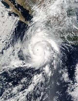
Hurricane Kenna was the second-most intense Pacific hurricane
to strike the west coast of Mexico
in recorded history. Kenna was the sixteenth tropical depression, thirteenth tropical storm, seventh hurricane, sixth major hurricane, and third Category 5 hurricane of the 2002 Pacific hurricane season
. After forming on October 22 to the south of Mexico from a tropical wave
, forecasters consistently predicted the storm to strengthen much less than it actually did. Moving into an area of favorable upper-level conditions and warm sea surface temperatures, Kenna quickly strengthened to reach peak winds of 165 mph (265 km/h) on October 25 while located about 255 mi (410 km) southwest of Puerto Vallarta
, Jalisco
. Weakening as it turned to the northeast, the hurricane struck near San Blas
, Nayarit
, with winds of 140 mph (225 km/h) before dissipating on October 26 over the Sierra Madre Occidental
mountains.
The name "Kenna" was retired from the list of Pacific hurricane names due to its effects on Mexico, which included $101 million in damage ($ USD) and four deaths. The worst of the hurricane's effects occurred between San Blas in Nayarit and Puerto Vallarta in Jalisco, where over 100 people were injured and thousands of homes and businesses were damaged or destroyed. 95% of the buildings in San Blas were damaged, and hundreds of buildings were destroyed along coastal areas of Puerto Vallarta.
moving westward through the Caribbean Sea
on October 16, possibly the same wave that passed near Barbados
two days earlier. The wave entered the eastern Pacific Ocean
on October 19, and a tropical disturbance along the wave axis gradually became better organized. Conditions favored continued development, and Dvorak classifications
began late on October 20. Early on October 22, the system developed into Tropical Depression Fourteen-E while located about 375 mi (605 km) south of Manzanillo
, Colima
. Initially the depression was disorganized, with little inner convective structure and sporadic deep convection. Computer models predicted an increase in wind shear
by 60 hours; as such the National Hurricane Center
forecast the depression to strengthen to a peak strength of 45 mph (70 km/h) before weakening.
The depression quickly became better organized with a great increase in convection near the center, and six hours after forming it strengthened into Tropical Storm Kenna. Upper-level outflow and banding features improved in organization, as well. With warm water temperatures of over 29 °C
(84.2 °F
) and updated model forecasts anticipating light amounts of vertical wind shear, forecasters predicted Kenna to slowly intensify to reach winds of 85 mph (135 km/h) within 72 hours of October 22. The storm moved to the west-northwest around the periphery of a mid-level high-pressure system
, and initially failed to strengthen further with much of its convection being associated with outer rainbands. On October 23, the outer rainbands dissipated and convection became more concentrated near the center, which coincided with a steady increase in strength. Late on October 23, Kenna intensified into a hurricane while located about 380 mi (615 km) southwest of Manzanillo.
Shortly after becoming a hurricane, Kenna began to rapidly intensify
with a 17 mi (27 km) wide eye
located within its well-defined central dense overcast. Early on October 24 Kenna became a major hurricane
, and in a 24 hour period the hurricane more than doubled its windspeed from 70 mph (115 km/h) winds to 145 mph (235 km/h). After turning to the north and northeast in response to the flow ahead of a large mid to upper-level trough
, Kenna attained peak winds of 165 mph (265 km/h) early on October 25 while located about 255 mi (410 km) southwest of Puerto Vallarta
, the third Category 5 hurricane of the season. A Reconnaissance Aircraft
flight into the hurricane while it was near peak intensity recorded a pressure of 913 mbar
(hPa
), the third lowest recorded pressure for a Pacific hurricane
.
Quickly after peaking, wind shear from the approaching trough weakened the hurricane, and by six hours after reaching peak intensity, the winds in Hurricane Kenna dropped to 150 mph (240 km/h) after the eye nearly dissipated. Despite a 27 mbar
increase in pressure in 12 hours, convective activity
increased prior to Kenna making landfall
. On October 25 Hurricane Kenna struck near San Blas
in the state of Nayarit
with estimated winds of 140 mph (225 km/h). The hurricane rapidly weakened over the mountainous terrain of western Mexico, and the circulation dissipated on October 26 over the Sierra Madre Occidental
mountains. The remnants continued northeastward into the Gulf of Mexico
and southeastern United States.
officials issued a hurricane watch from Mazatlán
to Cabo Corrientes
, with a tropical storm watch issued further south to Manzanillo
. Six hours later when its track became more apparent, the watch was upgraded to a hurricane warning from Mazatlán to La Fortuna, with a tropical storm warning southward to Manzanillo.
Roughly 8,800 of the 9,000 residents in the landfall location, San Blas
, evacuated, which ultimately contributed to a low death toll. Officials ordered for the evacuation of 50,000 residents and fishermen along the southwest coast of Mexico, including 3,000 in the Islas Marías
, 10,000 near Mazatlán, and 15,000 near flood-prone areas. Civil authorities closed all schools and docks in potentially affected areas. The Mexican Red Cross prepared for the storm by shipping 215 ton
nes of relief supplies such as food, water, clothing, and medicine to the Red Cross branch in Jalisco
. Assistance from the Yucatán Peninsula
delivered 10 ton
nes of food and water, as well. The Mexican Red Cross prepared 20 emergency shelters in the state of Nayarit. Officials took security measures in Los Cabos
, Baja California Sur
, where the Asia-Pacific Economic Cooperation
was meeting during the passage of the hurricane. Early forecasts indicated a possible threat to the meeting, causing the government to prepare for a potential alternate site. Officials recommended boats to stay at port due to severe conditions.
in San Blas
. The surge also affected Puerto Vallarta
, with reports of 10 foot (3 m) waves rushing inland from the bay. The hurricane dropped about 1.38 inches (35 mm) of precipitation while passing about 60 mi (95 km) east of the offshore archipelago, Islas Marías
. There, sustained winds reached an estimated 106 mph (170 km/h). On land, Kenna dropped heavy rainfall peaking at 18.91 inches (480 mm) at San Ignacio
, Sinaloa
, and 12.89 inches (327 mm) near Manzanillo
, Colima
. The highest recorded sustained wind on land was about 100 mph (161 km/h) at Tepic, Nayarit, with wind gusts at Puerto Vallarta reaching 50 mph (80 km/h). The hurricane also produced heavy rainfall in Guerrero
, Michoacán
, Colima
, and Jalisco
, and hit Baja California Sur
with strong winds and rough seas.
In San Blas
, strong winds from the hurricane damaged or destroyed 95% of the homes, with 1,540 houses damaged and 8,800 people affected. There, large commercial shrimp boats were swept up to 900 feet (275 m) inland from their docks. An elderly woman died in the city when the wall of her house collapsed on her. Large portions of the city were covered with building debris and sand washed from the ocean. Elsewhere in Nayarit
, flying debris killed a person in Santiago Escuintla. There, two elderly men drowned, one by falling into a river. Both were believed to have been killed during the storm as they fled their homes. In Santiago Ixcuintla
, the hurricane damaged 3,770 homes, and throughout Nayarit, strong winds from the hurricane destroyed the roofs of hundreds of houses. Federal authorities lost communications with at least 30 Indian villages due to the high winds of the hurricane. Kenna destroyed the entire banana, tobacco, and tomato crops in the rural areas of San Blas, Tecuala
, and Acaponeta
, leaving more than 700 subsistence farmers and their families in need of water and food.
In Puerto Vallarta
, about 100 mi (164 km) southeast of the landfall location, the storm surge resulted in an estimated damage total of $5 million (2002 USD, $) USD)}, primarily to hotels. The surge flooded the hotels and other waterfront areas, and extended up to 330 feet (100 m) inland. Waist-deep floodwaters swept away vans and cars, ruining several vehicles. The passage of the hurricane destroyed 150 stores near the ocean and extensively damaged three hotels. Damage to the city's port was minor.
The hurricane injured at least 52 in Puerto Vallarta and dozens in San Blas from widespread flying glass and other forms of debris, with two people seriously injured due to the hurricane. Ten municipalities
suffered substantial damage, with insured damage in Mexico totaling $96 million (2002 USD, $ USD). Rainfall from the hurricane spread across northern Mexico, causing minor flash floods and mudslides.
The remnants of Kenna entered the south-central United States, resulting in enhanced rainfall in various locations.
retired the name Kenna in April 2003 and replaced it with Karina in the list of names for the 2008 Pacific hurricane season
.
The Mexican government declared the region in Nayarit near the landfall of Kenna as a disaster area, allowing for the usage of emergency funds. Immediately after the passage of the hurricane, the Mexican Red Cross prepared 180 technical staff and volunteers from seven states to deliver 125 MT
of food, medicine, and clothes to the areas most affected. The Mexican government deployed the Mexican Army
to the area to remove fallen trees and establish water treatment plants to assist the affected population. The Mexican Navy
was sent to assist to support medical personnel in the San Blas area, and the government Department for Family Development assisted the Mexican Red Cross in delivering food. Grupo Modelo
, brewers of Corona beer
, sent 6,600 gallon
s (25,000 liters) of drinking water and 1,000 food sets for the San Blas area.
Backhoes and dump trucks gradually removed the debris and sand from San Blas. Dozens of storeowners, municipal employees, and volunteers in Puerto Vallarta worked to clear the debris caused by the storm. The remaining stores, bars, and shops placed signs on their windows describing they were open in effort to attract the tourists still in the town. By about two months after the hurricane, most hotels, restaurants, and shops were reopened.
Hurricane Kenna is currently the second most intense Pacific hurricane
to strike Mexico. The only Pacific hurricane to strike Mexico at a greater intensity was Hurricane Madeline
of 1976. Kenna is the second most intense October tropical cyclone to have occurred in the East Pacific, and is the third most intense East Pacific hurricane on record, behind only Hurricane Linda
of 1997 and Rick
of 2009.
Pacific hurricane
A Pacific hurricane or tropical storm is a tropical cyclone that develops in the northeastern part of the Pacific Ocean. For organizational purposes, the northern Pacific Ocean is divided into three regions: the eastern, , central , and western...
to strike the west coast of Mexico
Mexico
The United Mexican States , commonly known as Mexico , is a federal constitutional republic in North America. It is bordered on the north by the United States; on the south and west by the Pacific Ocean; on the southeast by Guatemala, Belize, and the Caribbean Sea; and on the east by the Gulf of...
in recorded history. Kenna was the sixteenth tropical depression, thirteenth tropical storm, seventh hurricane, sixth major hurricane, and third Category 5 hurricane of the 2002 Pacific hurricane season
2002 Pacific hurricane season
The 2002 Pacific hurricane season was an event in tropical cyclone meteorology. The most notable storm that year was Hurricane Kenna, which reached Category 5 on the Saffir-Simpson Hurricane Scale. It made landfall near Puerto Vallarta, in the Mexican state of Jalisco, on October 25...
. After forming on October 22 to the south of Mexico from a tropical wave
Tropical wave
Tropical waves, easterly waves, or tropical easterly waves, also known as African easterly waves in the Atlantic region, are a type of atmospheric trough, an elongated area of relatively low air pressure, oriented north to south, which move from east to west across the tropics causing areas of...
, forecasters consistently predicted the storm to strengthen much less than it actually did. Moving into an area of favorable upper-level conditions and warm sea surface temperatures, Kenna quickly strengthened to reach peak winds of 165 mph (265 km/h) on October 25 while located about 255 mi (410 km) southwest of Puerto Vallarta
Puerto Vallarta
Puerto Vallarta is a Mexican balneario resort city situated on the Pacific Ocean's Bahía de Banderas.The 2010 census reported Puerto Vallarta's population as 255,725 making it the sixth-largest city in the state of Jalisco...
, Jalisco
Jalisco
Jalisco officially Estado Libre y Soberano de Jalisco is one of the 31 states which, with the Federal District, comprise the 32 Federal Entities of Mexico. It is located in Western Mexico and divided in 125 municipalities and its capital city is Guadalajara.It is one of the more important states...
. Weakening as it turned to the northeast, the hurricane struck near San Blas
San Blas, Nayarit
San Blas is both a municipality and municipal seat located on the Pacific coast of Mexico in the state of Nayarit.-City:San Blas is a port and a popular tourist destination, located about 100 miles north of Puerto Vallarta, and 40 miles west of the state capital Tepic. The town has a population of...
, Nayarit
Nayarit
Nayarit officially Estado Libre y Soberano de Nayarit is one of the 31 states which, with the Federal District, comprise the 32 Federal Entities of Mexico. It is divided in 20 municipalities and its capital city is Tepic.It is located in Western Mexico...
, with winds of 140 mph (225 km/h) before dissipating on October 26 over the Sierra Madre Occidental
Sierra Madre Occidental
The Sierra Madre Occidental is a mountain range in western Mexico.-Setting:The range runs north to south, from just south of the Sonora–Arizona border southeast through eastern Sonora, western Chihuahua, Sinaloa, Durango, Zacatecas, Nayarit, Jalisco, Aguascalientes to Guanajuato, where it joins...
mountains.
The name "Kenna" was retired from the list of Pacific hurricane names due to its effects on Mexico, which included $101 million in damage ($ USD) and four deaths. The worst of the hurricane's effects occurred between San Blas in Nayarit and Puerto Vallarta in Jalisco, where over 100 people were injured and thousands of homes and businesses were damaged or destroyed. 95% of the buildings in San Blas were damaged, and hundreds of buildings were destroyed along coastal areas of Puerto Vallarta.
Meteorological history
The origin of Hurricane Kenna can be traced to a tropical waveTropical wave
Tropical waves, easterly waves, or tropical easterly waves, also known as African easterly waves in the Atlantic region, are a type of atmospheric trough, an elongated area of relatively low air pressure, oriented north to south, which move from east to west across the tropics causing areas of...
moving westward through the Caribbean Sea
Caribbean Sea
The Caribbean Sea is a sea of the Atlantic Ocean located in the tropics of the Western hemisphere. It is bounded by Mexico and Central America to the west and southwest, to the north by the Greater Antilles, and to the east by the Lesser Antilles....
on October 16, possibly the same wave that passed near Barbados
Barbados
Barbados is an island country in the Lesser Antilles. It is in length and as much as in width, amounting to . It is situated in the western area of the North Atlantic and 100 kilometres east of the Windward Islands and the Caribbean Sea; therein, it is about east of the islands of Saint...
two days earlier. The wave entered the eastern Pacific Ocean
Pacific Ocean
The Pacific Ocean is the largest of the Earth's oceanic divisions. It extends from the Arctic in the north to the Southern Ocean in the south, bounded by Asia and Australia in the west, and the Americas in the east.At 165.2 million square kilometres in area, this largest division of the World...
on October 19, and a tropical disturbance along the wave axis gradually became better organized. Conditions favored continued development, and Dvorak classifications
Dvorak technique
The Dvorak technique is a widely used system to subjectively estimate tropical cyclone intensity based solely on visible and infrared satellite images. Several agencies issue Dvorak intensity numbers for cyclones of sufficient intensity...
began late on October 20. Early on October 22, the system developed into Tropical Depression Fourteen-E while located about 375 mi (605 km) south of Manzanillo
Manzanillo, Colima
The name Manzanillo refers to the city as well as its surrounding municipality in the Mexican state of Colima. The city, located on the Pacific Ocean, contains Mexico's busiest port. Manzanillo was the third port created by the Spanish in the Pacific during the New Spain period...
, Colima
Colima
Colima is one of the 31 states which, with the Federal District, make up the 32 Federal Entities of Mexico. It shares its name with its capital and main city, Colima....
. Initially the depression was disorganized, with little inner convective structure and sporadic deep convection. Computer models predicted an increase in wind shear
Wind shear
Wind shear, sometimes referred to as windshear or wind gradient, is a difference in wind speed and direction over a relatively short distance in the atmosphere...
by 60 hours; as such the National Hurricane Center
National Hurricane Center
The National Hurricane Center , located at Florida International University in Miami, Florida, is the division of the National Weather Service responsible for tracking and predicting weather systems within the tropics between the Prime Meridian and the 140th meridian west poleward to the 30th...
forecast the depression to strengthen to a peak strength of 45 mph (70 km/h) before weakening.
The depression quickly became better organized with a great increase in convection near the center, and six hours after forming it strengthened into Tropical Storm Kenna. Upper-level outflow and banding features improved in organization, as well. With warm water temperatures of over 29 °C
Celsius
Celsius is a scale and unit of measurement for temperature. It is named after the Swedish astronomer Anders Celsius , who developed a similar temperature scale two years before his death...
(84.2 °F
Fahrenheit
Fahrenheit is the temperature scale proposed in 1724 by, and named after, the German physicist Daniel Gabriel Fahrenheit . Within this scale, the freezing of water into ice is defined at 32 degrees, while the boiling point of water is defined to be 212 degrees...
) and updated model forecasts anticipating light amounts of vertical wind shear, forecasters predicted Kenna to slowly intensify to reach winds of 85 mph (135 km/h) within 72 hours of October 22. The storm moved to the west-northwest around the periphery of a mid-level high-pressure system
Anticyclone
An anticyclone is a weather phenomenon defined by the United States' National Weather Service's glossary as "[a] large-scale circulation of winds around a central region of high atmospheric pressure, clockwise in the Northern Hemisphere, counterclockwise in the Southern Hemisphere"...
, and initially failed to strengthen further with much of its convection being associated with outer rainbands. On October 23, the outer rainbands dissipated and convection became more concentrated near the center, which coincided with a steady increase in strength. Late on October 23, Kenna intensified into a hurricane while located about 380 mi (615 km) southwest of Manzanillo.
Shortly after becoming a hurricane, Kenna began to rapidly intensify
Rapid deepening
Rapid deepening, also known as rapid intensification, is a meteorological condition that occurs when the minimum sea-level atmospheric pressure of a tropical cyclone decreases drastically in a short period of time. The National Weather Service describes rapid deepening as a decrease of...
with a 17 mi (27 km) wide eye
Eye (cyclone)
The eye is a region of mostly calm weather found at the center of strong tropical cyclones. The eye of a storm is a roughly circular area and typically 30–65 km in diameter. It is surrounded by the eyewall, a ring of towering thunderstorms where the second most severe weather of a cyclone...
located within its well-defined central dense overcast. Early on October 24 Kenna became a major hurricane
Saffir-Simpson Hurricane Scale
The Saffir–Simpson Hurricane Scale , or the Saffir–Simpson Hurricane Wind Scale , classifies hurricanes — Western Hemisphere tropical cyclones that exceed the intensities of tropical depressions and tropical storms — into five categories distinguished by the intensities of their sustained winds...
, and in a 24 hour period the hurricane more than doubled its windspeed from 70 mph (115 km/h) winds to 145 mph (235 km/h). After turning to the north and northeast in response to the flow ahead of a large mid to upper-level trough
Trough (meteorology)
A trough is an elongated region of relatively low atmospheric pressure, often associated with fronts.Unlike fronts, there is not a universal symbol for a trough on a weather chart. The weather charts in some countries or regions mark troughs by a line. In the United States, a trough may be marked...
, Kenna attained peak winds of 165 mph (265 km/h) early on October 25 while located about 255 mi (410 km) southwest of Puerto Vallarta
Puerto Vallarta
Puerto Vallarta is a Mexican balneario resort city situated on the Pacific Ocean's Bahía de Banderas.The 2010 census reported Puerto Vallarta's population as 255,725 making it the sixth-largest city in the state of Jalisco...
, the third Category 5 hurricane of the season. A Reconnaissance Aircraft
Hurricane Hunters
The Hurricane Hunters are aircraft that fly into tropical cyclones in the North Atlantic Ocean and Northeastern Pacific Ocean for the specific purpose of directly measuring weather data in and around those storms. In the United States, the Air Force, Navy, and NOAA units have all participated in...
flight into the hurricane while it was near peak intensity recorded a pressure of 913 mbar
Bar (unit)
The bar is a unit of pressure equal to 100 kilopascals, and roughly equal to the atmospheric pressure on Earth at sea level. Other units derived from the bar are the megabar , kilobar , decibar , centibar , and millibar...
(hPa
Pascal (unit)
The pascal is the SI derived unit of pressure, internal pressure, stress, Young's modulus and tensile strength, named after the French mathematician, physicist, inventor, writer, and philosopher Blaise Pascal. It is a measure of force per unit area, defined as one newton per square metre...
), the third lowest recorded pressure for a Pacific hurricane
Pacific hurricane
A Pacific hurricane or tropical storm is a tropical cyclone that develops in the northeastern part of the Pacific Ocean. For organizational purposes, the northern Pacific Ocean is divided into three regions: the eastern, , central , and western...
.
Quickly after peaking, wind shear from the approaching trough weakened the hurricane, and by six hours after reaching peak intensity, the winds in Hurricane Kenna dropped to 150 mph (240 km/h) after the eye nearly dissipated. Despite a 27 mbar
Bar (unit)
The bar is a unit of pressure equal to 100 kilopascals, and roughly equal to the atmospheric pressure on Earth at sea level. Other units derived from the bar are the megabar , kilobar , decibar , centibar , and millibar...
increase in pressure in 12 hours, convective activity
Convection
Convection is the movement of molecules within fluids and rheids. It cannot take place in solids, since neither bulk current flows nor significant diffusion can take place in solids....
increased prior to Kenna making landfall
Landfall (meteorology)
Landfall is the event of a tropical cyclone or a waterspout coming onto land after being over water. When a waterspout makes landfall it is reclassified as a tornado, which can then cause damage inland...
. On October 25 Hurricane Kenna struck near San Blas
San Blas, Nayarit
San Blas is both a municipality and municipal seat located on the Pacific coast of Mexico in the state of Nayarit.-City:San Blas is a port and a popular tourist destination, located about 100 miles north of Puerto Vallarta, and 40 miles west of the state capital Tepic. The town has a population of...
in the state of Nayarit
Nayarit
Nayarit officially Estado Libre y Soberano de Nayarit is one of the 31 states which, with the Federal District, comprise the 32 Federal Entities of Mexico. It is divided in 20 municipalities and its capital city is Tepic.It is located in Western Mexico...
with estimated winds of 140 mph (225 km/h). The hurricane rapidly weakened over the mountainous terrain of western Mexico, and the circulation dissipated on October 26 over the Sierra Madre Occidental
Sierra Madre Occidental
The Sierra Madre Occidental is a mountain range in western Mexico.-Setting:The range runs north to south, from just south of the Sonora–Arizona border southeast through eastern Sonora, western Chihuahua, Sinaloa, Durango, Zacatecas, Nayarit, Jalisco, Aguascalientes to Guanajuato, where it joins...
mountains. The remnants continued northeastward into the Gulf of Mexico
Gulf of Mexico
The Gulf of Mexico is a partially landlocked ocean basin largely surrounded by the North American continent and the island of Cuba. It is bounded on the northeast, north and northwest by the Gulf Coast of the United States, on the southwest and south by Mexico, and on the southeast by Cuba. In...
and southeastern United States.
Preparations
About 27 hours before landfall, MexicanMexico
The United Mexican States , commonly known as Mexico , is a federal constitutional republic in North America. It is bordered on the north by the United States; on the south and west by the Pacific Ocean; on the southeast by Guatemala, Belize, and the Caribbean Sea; and on the east by the Gulf of...
officials issued a hurricane watch from Mazatlán
Mazatlán
Mazatlán is a city in the Mexican state of Sinaloa; the surrounding municipio for which the city serves as the municipal seat is Mazatlán Municipality. It is located at on the Pacific coast, across from the southernmost tip of the Baja California peninsula.Mazatlán is a Nahuatl word meaning...
to Cabo Corrientes
Cabo Corrientes
Cabo Corrientes is a cape on the Pacific coast of the Mexican state of Jalisco. It marks the southernmost point of the Bahía de Banderas, upon which the port and resort city of Puerto Vallarta stands. The municipality in which the cape lies is also called Cabo Corrientes.Cabo Corrientes is a...
, with a tropical storm watch issued further south to Manzanillo
Manzanillo, Colima
The name Manzanillo refers to the city as well as its surrounding municipality in the Mexican state of Colima. The city, located on the Pacific Ocean, contains Mexico's busiest port. Manzanillo was the third port created by the Spanish in the Pacific during the New Spain period...
. Six hours later when its track became more apparent, the watch was upgraded to a hurricane warning from Mazatlán to La Fortuna, with a tropical storm warning southward to Manzanillo.
Roughly 8,800 of the 9,000 residents in the landfall location, San Blas
San Blas, Nayarit
San Blas is both a municipality and municipal seat located on the Pacific coast of Mexico in the state of Nayarit.-City:San Blas is a port and a popular tourist destination, located about 100 miles north of Puerto Vallarta, and 40 miles west of the state capital Tepic. The town has a population of...
, evacuated, which ultimately contributed to a low death toll. Officials ordered for the evacuation of 50,000 residents and fishermen along the southwest coast of Mexico, including 3,000 in the Islas Marías
Islas Marías
The Islas Marías are an archipelago of four islands that belong to Mexico. They are located in the Pacific Ocean, some off the coast of the state of Nayarit. They are part of the municipality of San Blas, Nayarit...
, 10,000 near Mazatlán, and 15,000 near flood-prone areas. Civil authorities closed all schools and docks in potentially affected areas. The Mexican Red Cross prepared for the storm by shipping 215 ton
Ton
The ton is a unit of measure. It has a long history and has acquired a number of meanings and uses over the years. It is used principally as a unit of weight, and as a unit of volume. It can also be used as a measure of energy, for truck classification, or as a colloquial term.It is derived from...
nes of relief supplies such as food, water, clothing, and medicine to the Red Cross branch in Jalisco
Jalisco
Jalisco officially Estado Libre y Soberano de Jalisco is one of the 31 states which, with the Federal District, comprise the 32 Federal Entities of Mexico. It is located in Western Mexico and divided in 125 municipalities and its capital city is Guadalajara.It is one of the more important states...
. Assistance from the Yucatán Peninsula
Yucatán Peninsula
The Yucatán Peninsula, in southeastern Mexico, separates the Caribbean Sea from the Gulf of Mexico, with the northern coastline on the Yucatán Channel...
delivered 10 ton
Ton
The ton is a unit of measure. It has a long history and has acquired a number of meanings and uses over the years. It is used principally as a unit of weight, and as a unit of volume. It can also be used as a measure of energy, for truck classification, or as a colloquial term.It is derived from...
nes of food and water, as well. The Mexican Red Cross prepared 20 emergency shelters in the state of Nayarit. Officials took security measures in Los Cabos
Los Cabos
Los Cabos is a municipality located at the southern tip of Mexico's Baja California Peninsula, in the state of Baja California Sur. It encompasses the towns of Cabo San Lucas and San José del Cabo , as well as the Resort Corridor that lies between the two...
, Baja California Sur
Baja California Sur
Baja California Sur , is one of the 31 states which, with the Federal District, comprise the 32 Federal Entities of Mexico. Before becoming a state on October 8, 1974, the area was known as the South Territory of Baja California. It has an area of , or 3.57% of the land mass of Mexico and comprises...
, where the Asia-Pacific Economic Cooperation
Asia-Pacific Economic Cooperation
Asia-Pacific Economic Cooperation is a forum for 21 Pacific Rim countries that seeks to promote free trade and economic cooperation throughout the Asia-Pacific region...
was meeting during the passage of the hurricane. Early forecasts indicated a possible threat to the meeting, causing the government to prepare for a potential alternate site. Officials recommended boats to stay at port due to severe conditions.
Impact
Few official surface observations are available for the passage of the hurricane. Upon making landfall, Kenna was accompanied with an estimated 16 foot (4.9 m) storm surgeStorm surge
A storm surge is an offshore rise of water associated with a low pressure weather system, typically tropical cyclones and strong extratropical cyclones. Storm surges are caused primarily by high winds pushing on the ocean's surface. The wind causes the water to pile up higher than the ordinary sea...
in San Blas
San Blas, Nayarit
San Blas is both a municipality and municipal seat located on the Pacific coast of Mexico in the state of Nayarit.-City:San Blas is a port and a popular tourist destination, located about 100 miles north of Puerto Vallarta, and 40 miles west of the state capital Tepic. The town has a population of...
. The surge also affected Puerto Vallarta
Puerto Vallarta
Puerto Vallarta is a Mexican balneario resort city situated on the Pacific Ocean's Bahía de Banderas.The 2010 census reported Puerto Vallarta's population as 255,725 making it the sixth-largest city in the state of Jalisco...
, with reports of 10 foot (3 m) waves rushing inland from the bay. The hurricane dropped about 1.38 inches (35 mm) of precipitation while passing about 60 mi (95 km) east of the offshore archipelago, Islas Marías
Islas Marías
The Islas Marías are an archipelago of four islands that belong to Mexico. They are located in the Pacific Ocean, some off the coast of the state of Nayarit. They are part of the municipality of San Blas, Nayarit...
. There, sustained winds reached an estimated 106 mph (170 km/h). On land, Kenna dropped heavy rainfall peaking at 18.91 inches (480 mm) at San Ignacio
San Ignacio, Sinaloa
San Ignacio is a city and seat of the surrounding San Ignacio Municipality in the Mexican state of Sinaloa. It stands at.In this town actress Ofelia Cano was born.The municipality reported 26,762 inhabitants in the 2000 census....
, Sinaloa
Sinaloa
Sinaloa officially Estado Libre y Soberano de Sinaloa is one of the 31 states which, with the Federal District, comprise the 32 Federal Entities of Mexico. It is divided in 18 municipalities and its capital city is Culiacán Rosales....
, and 12.89 inches (327 mm) near Manzanillo
Manzanillo, Colima
The name Manzanillo refers to the city as well as its surrounding municipality in the Mexican state of Colima. The city, located on the Pacific Ocean, contains Mexico's busiest port. Manzanillo was the third port created by the Spanish in the Pacific during the New Spain period...
, Colima
Colima
Colima is one of the 31 states which, with the Federal District, make up the 32 Federal Entities of Mexico. It shares its name with its capital and main city, Colima....
. The highest recorded sustained wind on land was about 100 mph (161 km/h) at Tepic, Nayarit, with wind gusts at Puerto Vallarta reaching 50 mph (80 km/h). The hurricane also produced heavy rainfall in Guerrero
Guerrero
Guerrero officially Estado Libre y Soberano de Guerrero is one of the 31 states which, with the Federal District, comprise the 32 Federal Entities of Mexico. It is divided in 81 municipalities and its capital city is Chilpancingo....
, Michoacán
Michoacán
Michoacán officially Estado Libre y Soberano de Michoacán de Ocampo is one of the 31 states which, with the Federal District, comprise the 32 Federal Entities of Mexico. It is divided in 113 municipalities and its capital city is Morelia...
, Colima
Colima
Colima is one of the 31 states which, with the Federal District, make up the 32 Federal Entities of Mexico. It shares its name with its capital and main city, Colima....
, and Jalisco
Jalisco
Jalisco officially Estado Libre y Soberano de Jalisco is one of the 31 states which, with the Federal District, comprise the 32 Federal Entities of Mexico. It is located in Western Mexico and divided in 125 municipalities and its capital city is Guadalajara.It is one of the more important states...
, and hit Baja California Sur
Baja California Sur
Baja California Sur , is one of the 31 states which, with the Federal District, comprise the 32 Federal Entities of Mexico. Before becoming a state on October 8, 1974, the area was known as the South Territory of Baja California. It has an area of , or 3.57% of the land mass of Mexico and comprises...
with strong winds and rough seas.
In San Blas
San Blas, Nayarit
San Blas is both a municipality and municipal seat located on the Pacific coast of Mexico in the state of Nayarit.-City:San Blas is a port and a popular tourist destination, located about 100 miles north of Puerto Vallarta, and 40 miles west of the state capital Tepic. The town has a population of...
, strong winds from the hurricane damaged or destroyed 95% of the homes, with 1,540 houses damaged and 8,800 people affected. There, large commercial shrimp boats were swept up to 900 feet (275 m) inland from their docks. An elderly woman died in the city when the wall of her house collapsed on her. Large portions of the city were covered with building debris and sand washed from the ocean. Elsewhere in Nayarit
Nayarit
Nayarit officially Estado Libre y Soberano de Nayarit is one of the 31 states which, with the Federal District, comprise the 32 Federal Entities of Mexico. It is divided in 20 municipalities and its capital city is Tepic.It is located in Western Mexico...
, flying debris killed a person in Santiago Escuintla. There, two elderly men drowned, one by falling into a river. Both were believed to have been killed during the storm as they fled their homes. In Santiago Ixcuintla
Santiago Ixcuintla
Santiago de Ixcuintla is a municipality and a municipal seat in the western Mexican state of Nayarit. The municipal population was 84,314 inhabitants with the municipal seat having 18,269. The area of the municipality was 1,831.92 square kilometers...
, the hurricane damaged 3,770 homes, and throughout Nayarit, strong winds from the hurricane destroyed the roofs of hundreds of houses. Federal authorities lost communications with at least 30 Indian villages due to the high winds of the hurricane. Kenna destroyed the entire banana, tobacco, and tomato crops in the rural areas of San Blas, Tecuala
Tecuala
Tecuala is both a municipality and a town in the Mexican state of Nayarit. The population of the municipality was 42,237 in a total area of 1,137 km² while the population of the town and municipal seat was 14,584...
, and Acaponeta
Acaponeta
Acaponeta is a both a municipality and a town in the northern part of the Mexican state of Nayarit. The town is located at the geographical coordinates of . The population of the municipality was 34,665 in the 2005 census, living in a total area of 1,667.7 km²...
, leaving more than 700 subsistence farmers and their families in need of water and food.
In Puerto Vallarta
Puerto Vallarta
Puerto Vallarta is a Mexican balneario resort city situated on the Pacific Ocean's Bahía de Banderas.The 2010 census reported Puerto Vallarta's population as 255,725 making it the sixth-largest city in the state of Jalisco...
, about 100 mi (164 km) southeast of the landfall location, the storm surge resulted in an estimated damage total of $5 million (2002 USD, $) USD)}, primarily to hotels. The surge flooded the hotels and other waterfront areas, and extended up to 330 feet (100 m) inland. Waist-deep floodwaters swept away vans and cars, ruining several vehicles. The passage of the hurricane destroyed 150 stores near the ocean and extensively damaged three hotels. Damage to the city's port was minor.
The hurricane injured at least 52 in Puerto Vallarta and dozens in San Blas from widespread flying glass and other forms of debris, with two people seriously injured due to the hurricane. Ten municipalities
Municipalities of Mexico
Municipalities are the second-level administrative division in Mexico . There are 2,438 municipalities in Mexico, making the average municipality population 45,616...
suffered substantial damage, with insured damage in Mexico totaling $96 million (2002 USD, $ USD). Rainfall from the hurricane spread across northern Mexico, causing minor flash floods and mudslides.
The remnants of Kenna entered the south-central United States, resulting in enhanced rainfall in various locations.
Retirement, aftermath and records
Because of the storm's damage in Mexico, the World Meteorological OrganizationWorld Meteorological Organization
The World Meteorological Organization is an intergovernmental organization with a membership of 189 Member States and Territories. It originated from the International Meteorological Organization , which was founded in 1873...
retired the name Kenna in April 2003 and replaced it with Karina in the list of names for the 2008 Pacific hurricane season
2008 Pacific hurricane season
The 2008 Pacific hurricane season was an event in the annual cycle of tropical cyclone formation. It officially started May 15, 2008 in the eastern Pacific, started on June 1, 2008 in the central Pacific, and lasted until November 30, 2008....
.
The Mexican government declared the region in Nayarit near the landfall of Kenna as a disaster area, allowing for the usage of emergency funds. Immediately after the passage of the hurricane, the Mexican Red Cross prepared 180 technical staff and volunteers from seven states to deliver 125 MT
Ton
The ton is a unit of measure. It has a long history and has acquired a number of meanings and uses over the years. It is used principally as a unit of weight, and as a unit of volume. It can also be used as a measure of energy, for truck classification, or as a colloquial term.It is derived from...
of food, medicine, and clothes to the areas most affected. The Mexican government deployed the Mexican Army
Mexican Army
The Mexican Army is the combined land and air branch and largest of the Mexican Military services; it also is known as the National Defense Army. It is famous for having been the first army to adopt and use an automatic rifle, , in 1899, and the first to issue automatic weapons as standard issue...
to the area to remove fallen trees and establish water treatment plants to assist the affected population. The Mexican Navy
Mexican Navy
The Mexican Navy is the naval branch of the Mexican military responsible for conducting naval operations. Its stated mission is "to use the naval force of the federation for the exterior defense, and to help with internal order". The Navy consists of about 56,000 men and women plus reserves, over...
was sent to assist to support medical personnel in the San Blas area, and the government Department for Family Development assisted the Mexican Red Cross in delivering food. Grupo Modelo
Grupo Modelo
Grupo Modelo is a large brewery in Mexico, It has 63% of the Mexican beer market, and exports beer to the United Kingdom, United States and Canada . Its export brands include Corona, Modelo, and Pacífico...
, brewers of Corona beer
Corona (beer)
Corona Extra, better known as Corona and labeled as Coronita in Spain, is a brand of pale lager owned and produced by Cerveceria Modelo at a number of breweries in Mexico. It is one of the best-selling beers in Mexico and is one of the top-selling beers worldwide...
, sent 6,600 gallon
Gallon
The gallon is a measure of volume. Historically it has had many different definitions, but there are three definitions in current use: the imperial gallon which is used in the United Kingdom and semi-officially within Canada, the United States liquid gallon and the lesser used United States dry...
s (25,000 liters) of drinking water and 1,000 food sets for the San Blas area.
Backhoes and dump trucks gradually removed the debris and sand from San Blas. Dozens of storeowners, municipal employees, and volunteers in Puerto Vallarta worked to clear the debris caused by the storm. The remaining stores, bars, and shops placed signs on their windows describing they were open in effort to attract the tourists still in the town. By about two months after the hurricane, most hotels, restaurants, and shops were reopened.
Hurricane Kenna is currently the second most intense Pacific hurricane
Pacific hurricane
A Pacific hurricane or tropical storm is a tropical cyclone that develops in the northeastern part of the Pacific Ocean. For organizational purposes, the northern Pacific Ocean is divided into three regions: the eastern, , central , and western...
to strike Mexico. The only Pacific hurricane to strike Mexico at a greater intensity was Hurricane Madeline
Hurricane Madeline (1976)
Hurricane Madeline was a Category 4 hurricane that made landfall in Mexico in October 1976. Madeline formed on September 29, not far from Central America. The next day, the circulation dissipated, and as a result weakened to a remnant low. Four days later, on October 3, the low regenerated into a...
of 1976. Kenna is the second most intense October tropical cyclone to have occurred in the East Pacific, and is the third most intense East Pacific hurricane on record, behind only Hurricane Linda
Hurricane Linda (1997)
Hurricane Linda was the strongest eastern Pacific hurricane on record. Forming from a tropical wave on September 9, 1997, Linda steadily intensified and reached hurricane status within 36 hours of developing. It rapidly intensified, reaching winds of and an estimated central pressure...
of 1997 and Rick
Hurricane Rick (2009)
Hurricane Rick was the second-most intense Pacific hurricane on record and the strongest ever to form during October. Developing south of Mexico on October 15, 2009, Hurricane Rick traversed an area favoring rapid intensification, allowing it to become a hurricane within 24 hours of being...
of 2009.
See also
- List of Pacific hurricanes
- List of retired Pacific hurricane names
- List of Category 5 Pacific hurricanes