

Jalisco
Encyclopedia
Jalisco officially Estado Libre y Soberano de Jalisco (Free and Sovereign State of Jalisco) is one of the 31 states which, with the Federal District
, comprise the 32 Federal Entities of Mexico
. It is located in Western Mexico
and divided in 125 municipalities
and its capital city is Guadalajara
.
It is one of the more important states in Mexico because of its natural resources as well as its history. Many of the characteristic traits of Mexican culture, particularly outside Mexico, are originally from Jalisco, such as mariachi
, ranchera music
, tequila
, jaripeo
, etc. Economically, it is ranked third in the country, with industries centered in the Guadalajara metropolitan area, the second largest metropolitan area in Mexico.
The state is home to two significant indigenous populations, the Huichol
s and the Nahuas. There is also a significant foreign population, mostly retirees from the United States and Canada, living in the Lake Chapala
area.
, Zacatecas
, Aguascalientes
, San Luis Potosí
, Guanajuato
, Colima
and Michoacán
with 342km of coastline on the Pacific Ocean
to the west.
Jalisco is made up of a diverse terrain that includes forests, beaches, plains and lakes. Altitudes in the state vary from between 0 and 4,300 meters above sea level from the coast to the top of the Nevado de Colima . The Jalisco area contains all five of Mexico’s natural ecosystems: arid and semi arid scrublands, tropical evergreen forests, tropical deciduous
and thorn forests, grasslands and mesquite
grasslands and temperate forests with oaks, pines and firs. Over 52% of the bird species found in Mexico live in the state, with 525, 40% of Mexico’s mammals with 173 and 18% of its reptile species. There are also 7,500 species of veined plants. One reason for its biodiversity is that is lies in the transition area between the temperate north and tropical south. It also lies at the northern edge of the Sierra Madre del Sur
and is on the Trans-Mexican Volcanic Belt
, which provides a wide variety of ecological conditions from tropical rainforest conditions to semi arid areas to areas apt for conifer forests.
Its five natural regions are Northwestern Plains and Sierras, Sierra Madre Occidental
, Central Plateau, Trans-Mexican Volcanic Belt, which covers most of the state and the Sierra Madre del Sur. It has an average altitude of 1550 masl, but ranges from 0 to over 4000 masl. Most of the territory is semi flat of between 600 and 2,050 masl, followed by rugged terrain of between 900 and 4,260 masl and a small percentage of flat lands of between 0 and 1,750 masl. Priniciple elevations include the Nevado de Colima, the Volcan de Colima, the Sierra El Madroño, the Tequila Volcano
, the Sierra Tapalpa, Sierra Los Huicholes, Sierra San Isidro, Sierra Manantlán, Cerro El Tigre, Cerro García, Sierra Lalo, Sierra Cacoma, Cerro Gordo, Sierra Verde and the Sierra Los Guajolotes.
Jalisco’s rivers and streams eventually empty into the Pacific Ocean and are divided into three groups: the Lerma/Santiago River
and its tributaries, rivers that empty directly into the Pacific and rivers in the south of the state. Jalisco has several river basins with the most notable being that of the Lerma/Santiago River, which drains the northern and northeastern parts of the state. The Lerma River enters extends from the State of Mexico and empties into Lake Chapala
on the east side. On the west, water flows out in the Santiago River, which crosses the center of Jalisco on its way to the Pacific, carving deep canyons in the land. Tributaries to the Santiago River include the Zula, the Verde River, the Juchipila and the Bolaños. About three quarters of the state’s population lives near this river system. In the southwest of the state, there are a number of small rivers that empty directly into the Pacific Ocean. The most important of these is the Ameca, with its one main tributary, the Mascota River. This river forms the state’s border with Nayarit and empties into the Ipala Bay. The Tomatlán, San Nicolás, Purificación, Marabasco-Minatitlán, Ayuquila, Tuxcacuesco, Armería and Tuxpan rivers flow almost perpendicular to the Pacific Ocean and drain the coastal area. Another river of this group is the Cihuatlán River, which forms the boundary between Jalisco and Colima emptying into the Barra de Navidad
Bay. The southeastern corner belongs to the Balsas River
basin. This includes the Ayuqila and Tuxcacuesco, which join to form the Armería and the Tuxpan.
 The other main surface water is Lake Chapala
, and is the largest and most important freshwater lake in Mexico, accounting for about half of the country’s lake surface.. The lake acts as a regulator of the flow of both the Lerma and Santiago Rivers. There are a number of seasonal and salty lakes linking to form the Zacoalco-Sayula land-locked system. There are other smaller lakes called Cajititlán, Sayula, San Marcos, and Atotonilco. Dams include the Cajón de Peña, Santa Rosa, La Vega, Tacotán and Las Piedras. Jalisco’s surface water accounts for fifteen percent of the surface freshwater in Mexico.
In 1986, four beaches in Jalisco were designated as federal marine turtle sanctuaries
: El Tecuán, Cuitzmala, Teopa and Playón de Mismaloya, with an extension of eight km. Playa Majahuitas is 27km southwest of Puerto Vallarta
with a rugged coastline, numerous inlets and outcroppings. The Cañon Submarino underwater canyon is located offshore. Chamela Bay has the greatest number of islet
s in Mexico, many of which are inhabited by numerous bird species.
Jalisco has eight areas under conservation measures totaling 208,653.8 hectares. Two contains scientific research centers. These areas cover 4.8% of the state and only one, the Sierra de Manantlán Biosphere accounts for sixty percent of all legally protected land at 139,500 hectares. The other protected areas include the Chamela-Cuitzmala Bioshere Reserve (13,143 hectares), Nevado de Colima National Park (10,143 hectares), Bosque de la Primavera (30,500 hectares), Sierra de Quila (15,1923 hectares) and the Marine Turtle Protection Zone (175.8 hectares) .
Thirteen plant communities are present in the state. Forty five to fifty percent of the state is characterized by deciduous and sub-deciduous forests. They occur along the coastal plains as well as in canyons in the central part of the state from sea level to 1600masl. Some areas, scattered within the tropical sub-deciduous forest along the coastal plains, are dominated by palms. Conifer and oak forests are most common in the highlands between 800 and 3,400masl, covering about one fourth of the state’s surface. One major conifer and oak forest is the Primavera Forest. Pine dominated areas in lower elevations are only found in the western corner of the state. Cloud and fir-dominated forests are restricted to ravines and protected steep slopes within the conifer and oak forest zones. Jalisco’s cloud forests include the Bosque de Maples and those on El Cerro de Manantlán. Savannas are found between 400 and 800 masl in the area the slopes towards the Pacific Ocean. These grasslands are a transition area between the tropical sub-deciduous forest and oak forest. The thorn forest includes an area of the coastal plains in the western part of the state as well as an area dominated by mesquite within the tropical deciduous forest. Grasslands are restricted to the northeastern corner interspersed with xerophilous scrub. There are mangroves along the ocean where waves are gentle. Beach and frontal dune vegetation dominates the rest of the coastline.
The coastal area receives the most precipitation and has the warmest temperatures, at an average of between 22 and 26C and an average precipitation of about 2,000 mm annually. In the north and northwest, a dry climate predominates with average temperatures of between 10 and 18C, and average annual precipitation between 300 and 1,000mm. The center of the state has three different climates, but all are mostly temperate with an average temperature of 19C and an average rainfall of between 700 and 1000mm. The northeastern corner and coastal plains of Tomatlán
are the driest areas with less than 500mm annually. The Los Altos region has a number of microclimate
s due to the rugged terrain. The area is mostly dry with an average temperature of 18C except in the north, where it fluctuates between 18 and 22C. In the highlands, the average temperature is less than 18C.
In various parts of the state there are areas with a semi-moist, temperate climate, some with average temperatures of between 10 and 18C and others of between 18 and 22C.
In the highlands of the Sierra de Manantlán, Cacola, Cuale and Mascota
near the coastal plains there is the most rainfall reaching 1600mm per year. In the highlands, the average temperature is less than 18C.
 As of 2010, the state population is 7,350,682, the fourth most populated state in Mexico, with 6.5% of Mexico’s total population. Over half of the state’s population lives in the Guadalajara metro area. Of the over 12,000 communities in the state, over 8,700 have a population of under fifty. 87% of the population lives in urban centers compared to 78% nationally.
Despite the fact that the number of children per woman has dropped by more than half from a high of 6.8 in 1970, the total population has grown from 5,991,175 in 1995 to the present number. One important factor in population growth is migration into the state. Since 1995, over 22% of the state population was born somewhere else. About three quarters of these live in the Greater Guadalajara area. Those who migrate into the state are from Michoacán, Mexico City
, State of Mexico, Sinaloa
and Baja California
. 87% live in urban areas, above the national average of 78% for the country.
The state ranks third in socioeconomic factors. As of 2010, there were 1,801,306 housing units in the state. 94.2% have running water, 97.4% have sewerage, 99% have electricity. 25% of households are headed by women, with 65.6% occupied by nuclear families. 22.2% are occupied by extended families.
There is also emigration from the state, mostly to the United States. Jalisco is ranked seventh in Mexico for the number of people who leave for this country. A large percentage of Mexicans migrating to the United States come from Jalisco. As of 2000, 27 of every 1000 residents lived in the United States, higher than the national average of 16 per 1000. Those who stay within Mexico generally head to Nayarit
, Baja California, Colima
, Michoacán and Guanajuato
.
There are no official numbers for ethnic groups but as of 2005, the state has a population of 42,372 people who spoke an indigenous language. Eight out of every 1000 people speak an indigenous language, above the national average of six per 1000. As of 2010, the most common indigenous language is Huichol
with 18,409 speakers, followed by Nahuatl
at 11,650, then P’urhépecha at 3,960 and variations of Mixtec at 2,001. In total, 51,702 people over the age of five speak an indigenous language, which is less than one percent of the total population of the state. Of these indigenous speakers fourteen percent do not speak Spanish. Municipalities with the highest indigenous population in general are Mezquitic
, Zapopan
and Guadalajara. Zapopan’s and Guadalajara’s indigenous population is mostly made up of those who have migrated to the area for work.
The Huichols are concentrated in the municipalities of Mezquitic and Bolaños
in the north of the state. In this same area are four of this ethnicity’s most important ceremonial centers, San Andrés Cohamiata, Santa Catarina Cuexcomatitlán, San Sebastián Teponahuaxtlán and Tuxpan de Bolaños. The fifth, Guadalupe Octán, is in Nayarit. The Huichols are of the same ethnic heritage as the Aztec
s and speak a Uto-Aztecan language
. They are best known for the preservation of their pre Hispanic shamanic traditions. The Huichol romanticize their past, when game was plentiful and they were free to roam the vast mountain ranges and deserts of their homeland. This was a time of freedom for them, before they became tethered to the growing of maize. Agriculture is difficult in the mountainous areas they live. Elaborate ceremonies are enacted to help ensure crops’ success. There are three basic elements in Huichol religion, which is corn, deer and the peyote
cactus. The last is obtained by a yearly pilgrimage to an area called Wirikuta
, where it is harvested with great ceremony.
Another distinct group living in the state is foreign temporary residents or expats, with overwhelming majority of which are from the United States and Canada, concentrated in and around the small town of Ajijic by Lake Chapala
. The Lake Chapala area has the largest population of Americans outside of the country. The phenomenon began at the beginning of the 20th century. Cars with U.S. plates are not uncommon and many signs are in English and Spanish. There are no official numbers but the number of ex-pats in the area is estimated at 20,000. Half of these are from the US with most of the rest from Canada with some from European and Asian countries. Most are retirees although there is a notable artist community. In the winter, the number of foreigners in the area can reach 50,000. Another area popular with foreigners is Lagos de Moreno
.
, Tlajomulco de Zúñiga
, Tlaquepaque
, Tonalá
and Zapopan
, with two others, Juanacatlán and Ixtlahuacán de los Membrillos
as suburbs. These municipalities extend over an area of 2.734km2 with a population density of 133.2 inhabitants per hectare (2005). The most highly concentrated municipality in the zone is the municipality of Guadalajara, followed by Zapopan.
The state as a whole consists of 125 municipalities which were organized into twelve administrative regions in 1996, called Norte, Altos Norte, Altos Sur, Ciénega, Sureste, Región Sur, Sierra de Amula, Costa Sur, Costa Norte, Sierra Occidental, Valles and Centro.
Altos Norte has eight municipalities: Villa Hidalgo
, Unión de San Antonio
, Teocaltiche
, San Juan de los Lagos
, San Diego de Alejandría
, Ojuelos de Jalisco, Lagos de Moreno
and Encarnación de Díaz
.
Altos Sur consists of twelve municipalities: Yahualica de González Gallo, Valle de Guadalupe
, Tepatitlán de Morelos
, San Miguel el Alto
, San Julián
, San Ignacio Cerro Gordo, Mexticacán
, Jesús María
, Jalostotitlán
, Cañadas de Obregón
, Arandas and Acatic
.
The Centro Region consists of thirteen municipalites: Zapotlanejo
, Zapopan
, Villa Corona
, Tonalá
, Tlaquepaque
, Tlajomulco de Zúñiga
, San Cristóbal de la Barranca
, Juanacatlán, Ixtlahuacán del Río
, Guadalajara, El Salto
, Cuquío
and Acatlán de Juárez
.
The Ciénega Region contains thirteen municipalities: Zapotlán del Rey
, Tuxcueca
, Tototlán
, Tizapán el Alto
, Poncitlán
, Ocotlán, La Barca, Jocotepec
, Jamay
, Degollado, Chapala, Ayotlán
and Atotonilco El Alto
.
The Costa Norte has three municipalities: Tomatlán
, Puerto Vallarta
and Cabo Corrientes
.
The Costa Sur has six municipalities: Villa Purificación
, La Huerta
, Cuautitlán de García Barragán
, Cihuatlán, Casimiro Castillo
and Autlán de Navarro .
The Norte Region has ten municipalities: Villa Guerrero, Totatiche
, Santa María de los Ángeles
, San Martín de Bolaños
, Mezquitic
, Huejúcar
, Huejuquilla el Alto
, Colotlán
, Chimaltitán, and Bolaños .
The Sierra de Amula has eleven municipalities: Unión de Tula
, Tuxcacuesco
, Tonaya
, Tenamaxtlán, Tecolotlán
, Juchitlán
, El Limón
, El Grullo
, Ejutla
, Chiquilistlán
and Atengo
.
The Sierra Occidental has eight municipalities: Talpa de Allende
, San Sebastián del Oeste
, Mixtlán
, Mascota
, Guachinango
, Cuautla
, Ayutla
and Atenguillo
.
The Sur Region has sixteen municipalities: Zapotlán el Grande
, Zapotitlán de Vadillo
, Zapotiltic
, Zacoalco de Torres
, Túxpan
, Tonila, Tolimán
, Teocuitatlán de Corona
, Techaluta de Montenegro
, Tapalpa
, Sayula
, San Gabriel
, Gómez Farías, Atoyac, Atemajac de Brizuela
and Amacueca
.
The Sureste Region has ten municipalities: Valle de Juárez
, Tecalitlán
, Tamazula de Gordiano
, Santa María del Oro
, Quitupan
, Pihuamo
, Mazamitla
, La Manzanilla de la Paz
, Jilotlán de los Dolores
and Concepción de Buenos Aires
.
The Valles Region has fourteen municipalities: Teuchitlán
, Tequila
, Tala
, San Martín Hidalgo, San Marco, San Juanito de Escobedo, Magdalena
, Hostotipaquillo
, Etzatlán
, El Arenal
, Cocula
, Ameca
, Amatitán
and Ahualulco de Mercado
.
Xalisco, which means over a sandy surface. Until about 1836, the name was spelled “Xalisco,” with the “x” used to indicate the “sh” sound from Nahuatl. However, the modern Spanish based pronunciation is represented with a “j.” The coat of arms for Guadalajara was adopted and adapted as the state seal since 1989 with minor changes to distinguish the two. The nickname for people from Jalisco, “tapatío
” origin although Franciscan Alonso de Molina
wrote that it came from an indigenous word that means “the price of something purchased.”
s and cave paintings found at Cabo Corrientes, San Gabriel, Jesús María, La Huerta, Puerto Vallarta, Mixtlán, Villa Purificación, Casimiro Castillo, Zapotlán el Grande and Pihuamo.
Agriculture began in the same region as well around 7,000 years ago, giving rise to the first permanent settlements in western Mexico. Ceramics began to be produced about 3,500 years ago for both utilitarian and ceremonial purposes. The oldest pieces of Jalisco area pottery are called El Opeño, after an area near Zamora, Michoacán
and Capacha after an area in Colima
. The appearance of these styles indicates a certain specialization of labor, with distinct settled cultures established by 1000 BCE. The earliest settled cultures were centered on the site of Chupícuaro, Guanajuato, which has a large zone of influence from Durango
east, crossing through modern Jalisco’s north. Sites related to these cultures have been found in Bolaños, Totoate, the Bolaños River Canyon and Totatiche as well as other locations in the Los Altos Region. Cultures dating to the early part of the Christian era are distinguished by the use of shaft tombs
, with major examples found in Acatlán de Juárez, El Arenal and Casimiro Castillo. The use of this type of tomb is unkno
wn anywhere else in Mexico.
In the 7th century, Toltec
and Teotihuacan
influence is evident in the area, with a dominion called Xalisco established by the Toltecs in 618. The dominion was established through the military domination of the weaker local groups. During this time, ceramics were improved and the working of gold, silver and copper appeared. More recent archeology of the area has produced evidence of larger cities, large scale irrigation and a kind of script used by various cultures of the area. The Toltec influence had a strong influence over religious development with deities formalizing into gods recognized by the later Aztec civilization such as Tlaloc
, Mictlantecuhtli
and Quetzalcoatl
. A number of cities were built during this time, including Ixtepete, which show many features of Mesoamerica
n architecture such as the building of pyramid bases, temples and Mesoamerican ball courts. However, these are sparse because there were very few communities of the size needed to support them. Stones used for building were often cut in angles and with relief such as those found in Tamazula and El Chanal
, Colima. Ixtepete from the tenth century has talud/tablero construction showing Teotihuacan influence. By 1112, the tribes dominated by the Toltecs rebelled and brought an end to the domination; however, the area would be conquered again in 1129, this time by the Chichimeca
s.
By 1325, the P’urhépecha had become dominant in parts of the state, but in 1510, the indigenous settlements of Zapotlán, Sayula and Zacoalco pushed back the P’urhépecha during the Salitre War .
One reason for ancient civilizations in the area was the large deposits of obsidian
and it was the center of the Teuchitlán nation. Evidence of the most advanced pre Hispanic cultures are found in the center and south of the state. The most important site is Ixtepete in Zapopan
which dates from between the 5th and 10th centuries and shows Teotihuacan influence. Other sites include Atitlán, El Mirador, El Reliz and Las Cuevas in San Juanito de Escobedo, Portezuelo in Ameca, Santa Cruz de Bárcenas in Ahualulco de Mercado, Santa Quitería, Huaxtla and Las Pilas in El Arenal, La Providencia, Laguna Colorada, Las Cuevas, El Arenal and Palacio de Oconahua in Etzatlán, Cerro de la Navaja, Huitzilipa and Xochitepec in Magdalena and the Ixtapa Ceremonial Center in Puerto Vallarta.
border.
Shortly after the conquest of the Aztecs in 1521, the Spanish pushed west. They overpowered the P’urepécha in Michoacán, converting their capital of Tzintzuntzan
as a base to move further west. One reason for the push towards the Pacific was to build ships and shipping facilities in order to initiate trade with Asia. Another draw was to find more mineral wealth as the P’urépecha had already developed copper working along with silver and gold.
In 1522, Cristóbal de Olid
was sent by Hernán Cortés
northwest from Mexico City into Jalisco. Other incursions were undertaken by Alonso de Avalos and Juan Alvarez Chico in 1521, Gonzalo de Sandoval
in 1522 and Francisco Cortés de San Buenaventura in 1524. The first area explored now belongs to the south of Jalisco down into what it now the state of Colima. In 1529, the president of the First Audencia in New Spain, Nuño de Guzmán came west from Mexico City with a force of 300 Spanish and 6,000 Indian allies, traveling through Michoacán, Guanajuato, Jalisco and Sinaloa. At the end of 1531, Guzmán founded the Villa del Espíritu Santo de la Mayor Españas as the capital of the newly conquered western lands. The name was changed shortly thereafter to Santiago Galicia de Compostela. In 1531, Guzmán ordered his chief lieutenant, Juan de Oñate to found the Villa of Guadalajara, named after Guzmán’s hometown in Spain. It was initially founded in what is now Nochistlán
in Zacatecas
. Construction began in 1532, but the small settlement came under repeated attacks from the Cazcanes until it was abandoned in 1533. The town of Guadalajara would move four times in total before coming to its modern site in 1542.
Most of Jalisco was conquered by Nuño de Guzmán, who then sent expeditions from there into Zacatecas and Aguascalientes in 1530. The first encomienda
s were granted to the Spanish conquistadors in Nueva Galicia by Nuño de Guzmán and later by Antonio de Mendoza. Nuño de Guzmán founded five Spanish settlements, San Miguel, Chiametla, Compostela, Purificación and Guadalajara to form the first administrative structure of the area. However, most of these settlements were too small to support the grand plans of many Spanish in America and attracted few settlers. By the end of the early colonial period, all of these settlements either disappeared or were moved to other locations. Guzmán was named the first governor of the region and Franciscans established monasteries in Tetlán and Ajijic.
Guzmán was brutal to the local indigenous populations, sending many to slavery in the Caribbean and committing genocide in areas. This would eventually lead to his imprisonment in 1536 by viceroy Antonio de Mendoza
. However, not only Guzmán was to blame for subsequent indigenous hostility. The Spanish in Guadalajara and other locations began to take indigenous peoples as slaves in 1543. These Spanish in the area were looking to enrich themselves as fast as possible, following the success of the same of those who arrived first to the Mexico City area. This led to abuses of the native populations, widespread corruption and confrontations between the Spanish and the indigenous and among the Spanish themselves. Overwork and disease reduced the native population by about ninety percent between 1550 and 1650.
This would begin a history of conflict and uprising in the Jalisco area which would last from the 16th century to the 1920s. Early uprisings include that in Culiacán in 1533, of the Coaxicoria in 1538 and the Texcoixines and Caxcanes in 1541. Subduing the indigenous peoples proved difficult in general due to a lack of large dominion to co-opt as was done in the Mexico City area. In the early colonial period, it was not certain that the Spanish could impose its language or culture onto the native population. The initial effect of colonization was the influence of Nahuatl, as mestizos and indigenous from central Mexico had a greater impact on the local populations than the sparse Spanish.
The most significant early revolt was the Mixtón Rebellion
in 1541. United under a leader named Tenamaxtli, the indigenous of the Jalisco area laid siege to Guadalajara. The Spanish provincial government under Oñate could not withstand the assault and Pedro de Alvarado
was sent to area from Mexico City but this initial attempt was thwarted. During a battle, a horse fell on Alvarado, mortally wounding him. Viceroy Mendoza then arrived with a force of 300 horsemen, 300 infantry, artillery and 20,000 Tlaxcalan and Aztec allies to recapture the territory held by the indigenous resistance. The Mixtón War prompted Charles V to create the Audencia of Nueva Galicia which extended from Michoacán and into the present states of Jalisco, Colima, and parts of Zacatecas, Durango and Sinaloa. An Indian Council was formed to advise the four members of the new Spanish government. The area was called Nueva Galicia because the Crown wanted to reproduce in the new lands a territory similar to that of Spain. The seat of this colony was moved to Guadalajara in 1561, and it was made independent of Mexico City in 1575.
Most of the evangelization fell to regular clergy instead of monks. The bishopric of Guadalajara was established by Pope Paul II in 1546.
The Chichimeca War began in 1550. In 1554, the Chichimecas attacked a Spanish caravan of sixty wagons at the Ojuelos Pass, carrying off 30,000 pesos of clothing, silver and other valuables. At the end of the century, the Spanish were able to negotiate a peace with most. There later uprisings such as in Guaynamota in 1584, in Acaponeta in 1593, one led by Cogixito in 1617, and one in Nostic in 1704. The last major colonial era insurrection occurred in 1801 led by an indigenous named Mariano. The last of the Chichimeca groups were ultimately defeated in 1591. However, these uprisings would gradually be overshadowed by the consolidation of political and economic power and peace treaties negotiated with indigenous groups such as the Coras and indigenous groups such as the Otomi were brought to settle.
The province of Jalisco was separated from Michoacán in 1607 with the name of Santiago.
Despite these conflicts, the 17th and 18th centuries brought development and economic prosperity to the region. In the colonial period, Guadalajara grew as the center of an agricultural and cattle produing area. Guadalajara grew from about 6,000 people in 1713 to 20,000 in mid century to 35,000 at the beginning of the 19th century. The region’s ceramic tradition began in the early colonial period, with native traditions superimposed by European ones. The center of ceramic production was Tonalá due to its abundance of raw materials. The Guadalajara tradition became famous enough for wares to be exported to other parts of New Spain and Europe. The area was also important to the commerce of New Spain, as its strategic location funneled imported goods to other parts of the colony.
In 1786, New Spain was reorganized into twelve “intendencias” and three provinces. The Intendencia of Guadalajara included what is now Jalisco, Aguascalientes, Nayarit and Colima. Aguascalientes was separated from Jalisco in 1789.
The University of Guadalajara
was founded in 1792.
Political instability in Spain, news of rebellions in South America and Miguel Hidalgo’s Grito de Dolores
prompted small groups to begin fighting against Spanish rule. There were two main groups in Jalisco, one headed by Navarro, Portual and Toribio Huirobo in areas such as Jalostotitlán, Arandas, Atotonilco and La Barca and the other headed by José Antonio Torres in Sahuayo, Tizapán el Alto, Atoyac and Zacoalco. Another insurrection occurred in 1812 along Lake Chapala with Mezcala Island as an insurgent fortress. Skirmishes between the indigenous there and royalist forces lasted until 1816, when lacking supplies, the insurgents accepted an amnesty. Insurgent sympathies led to economic advantages for the Mexican born criollo
s over the Spanish born with many Spanish families moving into the city of Guadalajara for safety.
Miguel Hidalgo’s army entered Jalisco during the Mexican War of Independence
. In 1810, Guadalajara José Antonio Torres defeated the local royalist army and invited Hidalgo and his troops into the city. Hidalgo was heading west from the State of Mexico, pursued by Felix María Calleja and his troops loyal to the Spanish king. Hidalgo entered the city in November of 1810. Hidalgo’s troops arrested many Spanish, and Hidalgo issued a decree abolishing slavery. Hidalgo was able to recruit soldiers for his army in the city, bringing it up to 80,000 men by the time Calleja arrived in January 1811. The rebels took up positions outside the city at a place called the Puente de Calderón. Royalist forces won this battle, ending the initial phase of the War and forcing Hidalgo to flee north. Hidalgo was captured and executed later that year.
The end of Hidalgo did not finish insurgent aspirations. The newspaper “Despertador Americano” was founded in 1811 in Guadalajara, sympathetic to the insurgent cause. However, no other major battles of the war would be fought in the state.
Independence was won by Agustín de Iturbide
’s Army of the Three Guarantees
, which would make Iturbide Mexico’s first emperor, and making Jalisco one of a number of “departments” which answered directly to Mexico City. This act broke Nueva Galicia’s tradition of relative independence and provoked support for federalism. In 1821, a proposal for a “Republic of the United States of Anáhuac” circulated in Guadalajara which called for a federation of states to allow for the best political union in Mexico. Much of these principles appeared with the 1824 Constitution which was enacted after Iturbide was dethroned. Under this Constitution, Colima, Aguascalientes and Nayarit were still part of Jalisco. Its first governor was Prisciliano Sánchez. The new state was divided into eight cantons, Guadalajara, Lagos, La Barca, Sayula, Etzatlán, Autlán, Tepic and Colotlán.
Independence and the new Constitution did not bring political stability to Jalisco or the rest of the country. In the sixty-year period from 1825 to 1885, Jalisco witnessed twenty-seven peasant (primarily indigenous) rebellions. Seventeen of these uprisings occurred within one decade, 1855-64, and the year 1857 witnessed ten separate revolts. Along with the rest of the county, Jalisco’s states vacillated between state and department as Liberals (who supported federalism) and Conservatives fought for permanent control of Mexico. The peasant rebellions and other political acts were in favor of the Liberals and against centralize rule from Mexico City. Jalisco and other western states tried to form a coalition in 1834 against the rule of Antonio López de Santa Anna
, but the leaders of Guadalajara were forced to resign under threat of violence instigated by Santa Anna sympathizers, keeping the state in line.
During the Mexican-American War, Jalisco planned defensive measures along with the states of Mexico, Querétaro
, San Luis Potosí
, Zacatecas and Aguascalientes. However, although the U.S. Navy came as close as the port of San Blas
, the state was not invaded before the war ended.
The national struggles between Liberals and Conservatives continued in the 1850s and 1860s, with Jalisco’s government changing eighteen times between 1855 and 1864. While there was support for Federalism, most Liberals were politically aligned against the Church, which enjoyed strong support in the state. During the Reform War
, Benito Juárez
’s Liberal government was forced out of Mexico City, arriving to Guadalajara in 1858. Despite this, Conservatives in power made Jalisco a department under direct rule from Mexico City. Jalisco remained mostly in Conservative hands until 1861. The war was devastating to the state´s economy and forcing mass migrations. Of the thirty most important battles of the Reform War, twelve took place in Jalisco territory.
During the French Intervention in Mexico
, French forces supporting Mexico’s second emperor Maximilian I
, entered the state in 1865.The emperor was mostly not supported by the people of the state and in the following year, French forces were defeated at the La Coronilla Hacienda in Acatlán by Mexican General Eulogio Parra. This would allow Liberal forces to retake Guadalajara and push French forces out of the state. One permanent result of the French occupation was the separation of the San Blas area into a separately administered military district, which would eventually become the state of Nayarit.
In the 1870s, more than seventy percent of the population lived in rural areas.(vaivén) By 1878, the state of Jalisco extended over 115,00km2 with twelve cantons, thirty department and 118 municipalities, accounting for ten percent of the country’s population.
The end of the century would be dominated by the policies of Mexican President Porfirio Díaz
. Livestock, which had been a traditional economic pillar of the state, began to decline during this time. The state’s agricultural output also declined slightly relative to the rest of the country during the same period. However, Guadalajara was one of the wealthiest cities in Mexico.
visited Guadalajara twice, once in 1909 to campaign and the other in 1910 to organize resistance to the Díaz regime.
During the Mexican Revolution
, most of the rural areas of the state supported Venustiano Carranza
, with uprisings in favor of this army in Los Altos, Mascota, Talpa, Cuquío, Tlajomulco, Tala, Acatlán, Etzatlán, Hostotipaquillo, Mazamitla, Autlán, Magdalena, San Andrés and other places. However, these were isolated incidences and did not coalesce into an organized army to confront the federal government. Carranza vied for power in the state with Álvaro Obregón
and Francisco Villa during the early part of the war with skirmishes among the various forces, especially between those loyal to Carranza and Villa.
In 1914, Carranza supporter Manuel M. Diéguez was named governor of Jalisco. Diéguez persecuted the clergy, confiscated the property of the rich and imprisoned or executed the supporters of Victoriano Huerta
, whose forces he had pushed out of the city. Villa forced Diéguez to flee and released imprisoned clergy, but he too took money from the rich to give to the poor in exchange for their support. However, by April 1915, Carranza’s forces were on the rise again, pushing Villa’s forces out and reinstating Diéguez as governor.
Carranza gained the Mexican presidency in 1915, putting into place various social and economic reforms such as limits on Church political power and redistribution of agricultural lands. One major consequence of the Revolution was the 1917 Constitution
. This put severe constraints of the Church including the secularization of public education and even forbade worship outside of churches. One other result was the creation of Jalisco’s current boundaries.
The new restrictions on the Church by the Constitution were followed by further laws against the practice of religion which were not supported by many in the state. The lower classes split into those loyal to the church and not. In particular were the “Intolerable Acts” enacted by President Plutarco Elías Calles
. In 1926, a boycott was organized against these laws. In 1927, thirteen Catholic unions organized by priest Amando de Alba took up arms against the government in an uprising called the Cristero War
. In 1928, Cristero leaders formed a rebel government in areas controlled by them, which was mostly in the Los Altos and far northern areas of the state.The struggle resulted in ten different governors of the state between 1926 and 1932. At its height, the Cristeros had a force of about 25,000 until the conflict was officially ended in 1929, with sporadic outbreaks of violence continuing until the 1930s. This waning of hostilities was due to the lack of enforcement of the Calles laws, despite remaining on the books.
During this time, the modern University of Guadalajara
was founded in 1926, but it was closed in 1933, then reopened in 1939.
More successful was the implementation was economic reforms begun by Carranza in 1915. By 1935, various agricultural lands were redistributed in the form of ejidos and other communal land ownership.
From 1950s, the major concern for the state has been economic development. Most of the state’s development has been concentrated in its capital of Guadalajara, resulting is economic inequality in the state.
In 1974, a guerilla group kidnapped former governor José Guadalupe Zino but released him days after.
Ciudad Guzmán, the center of the 1985 earthquake
that destroyed parts of Mexico City, received reconstruction aid. Another major earthquake affected the population of Cihuatlán
, Jalisco.
 The most important tourist areas in the state are Puerto Vallarta
, the Guadalajara metro area, the Costalegre
and Los Altos Regions, Lake Chapala
and the Montaña Region.
The Guadalajara area’s attractions are principally in the city itself and Zapopan
, Tlaquepaque
and Tonalá
. Although the area is mostly urban there are also rural zones such as the Bosque La Primavera, El Diente and Ixtepete.
One of the most famous tourism attractions of the state is the “Tequila Express
” which runs from Guadalajara to the town of Tequila
. This tour includes visits to tequila distilleries which often offer regional food in buffets accompanied by mariachi
musicians and regional dancers. The Tequila Valley area is known for the liquor named after it, made primarily from the blue agave plant. This valley is filled with tequila haciendas, archeological sites and modern distillation facilities. The main historical centers are the towns of Tequila, Cocula, Magdalena and Teuchitlán. The aggregate of the agave fields in this area have been named a World Heritage site
by UNESCO
.
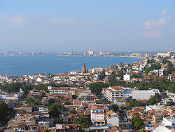
Puerto Vallarta on Banderas Bay has beaches such as Los Muertos, Conchas Chinas, Las Glorias, Mismaloya, Punta Negra and Playa de Oro with large hotels, bars, restaurants and discoteques. It has a population of about 250,000 and is the sixth largest city in Jalisco. This bay was a haven for pirates in the 16th century, but today it is one of Mexico’s favored diving destinations because of the range of marine life and an average water temperature of between 19 and 23C. Expert level diving is practiced at Marieta Islands at the edge of the bay. On land, one major attraction is the city’s nightlife. Ecotourism and extreme sports such as bungee jumping
and parasailing
are available.
Jalisco’s coast includes other beaches such as Careyes, Melaque, Bucerías and Tamarindo along with world famous Puerto Vallarta. The north part of the coast is called the Costalegre de Jalisco
. The Costalegre area is classified as a ecological tourism corridor with beaches such as Melaque, Barra de Navidad, Tenacatita, Careyes, El Tecuán, Punta Perula, Chamela and El Tamarindo. All of these have five-star hotels along with bars, restaurants and discoteques. Many coast areas offer activities such as scuba, snorkeling, kayaking, and sports fishing. Majahuas is a marine turtle sanctuary in which visitors may liberate newly hatched turtles into the sea. Puerto Vallarta is known for its nightlife along with its beaches.
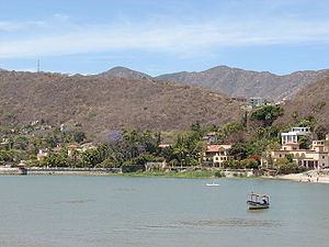
The popularity of Lake Chapala
began with President Porfirio Díaz who chose the area as a getaway in the late 19th century. This made it popular with Mexico’s elite and established the lake’s reputation. Today, Lake Chapala is popular as a weekend getaway and the area is home to a large foreign population. The lake is a tourist attraction, on which people sail, fish and jet ski
. The Lake is surrounded by a number of small rural towns including Ixtlahuacán de los Membrillos, Ocotlán and Tizapán el Alto. The area has been promoting ecotourism with activities such as rock climbing
, rappelling, hiking, golf and tennis along with spas/water parks such as those in Chapala, Jamay, La Barca and Jocotepec.
The Norte Region is the home of the Wixarika or Huichols although there are significant communities of an ethnicity called the Cora
as well. The area is known for its indigenous culture as well as its rugged, isolated terrain. Major communities in the area include Bolaños and Huejúcar. There is also ecotourism in the way of rappelling, rafting and camping.
The Zonas Altos refer to the area’s altitude. The area is marked by parish churches with tall towers. Religion is important in this area, with many pilgrimages, festivals, charreds. It is home to one of the most important pilgrimage sites of Mexico, that of the Virgin of San Juan de los Lagos . Religious tourism is a major economic activity, with the town of San Juan de los Lagos
completely dependent on serving the nearly seven million who visit each year. The area also has old haciendas open to tourism. There is some tequila production as well although most occurs in the Valles Region.
The Montaña or Mountain Region contains mountain chains such as the Sierra de Tapalpa, Sierra del Tigre and the Sierra del Halo. The main communities in this area are Tapalpa and Mazamitla. The area is filled with forests and green valleys and the state promotes ecotourism in the area with activities such as rappelling, mountain biking
, parasailing and hiking. The area’s gastronomy includes local sweets and dairy products.
The Sierra Region is between the Centro and coastal areas. Mountains chains in this area include the Sierra de Quila and the Sierra de Manatlán.
s, rodeos called charreada
s and jaripeo
s, dresses with wide skirts decorated with ribbons, the Mexican Hat Dance, tequila
and the wide brimmed sombrero hat.
. Its true origin is unknown but one theory states that it has an indigenous origin. Another postulates that it comes from a local pronunciation of a common mariachi song “María ce son.” It is thought to have originated from the town of Cocula, and this kind of band, with variations, spread into Sinaloa, Michoacán, Colima, Nayarit and Zacatecas. The music became most developed in and around the city of Guadalajara, which has a Mariachi Festival in September.
Other common folk music in the state is the jarabe
and the son
. The jarabe is a type of music which began as a type of hymn especially to the Virgin of Guadalupe. During the Mexican War of Independence
, this style was adopted by the insurgents for secular music as well. Some example of famous traditional songs in this style include “Los Enanos,” “El Gato,” “El Palo” and “El Perico.” However, the most famous song is the “Jarabe Tapatío.” The word “jarabe” is thought to come from the Arabic
word “sharab” which means syrup or something sweet. The musical style has its roots in Andalucia, Spain and was transplanted to Mexico. The jarabe is mostly associated with Jalisco but it is also popular in a number of other western states such as Nayarit, Colima and Guanajuato. Sons are particularly popular in the south of the state. Some traditional ones from Jalisco include El Son de la Madrugada, El Sion de las Alanzas, El Son del la Negra and El Son de las Copetonas.
to various parts of the country, as it was worn by a number of famous female soldiers of the time. Today, it is one considered one type of traditional Mexican dress. Today, this dress is mostly worn for dancing to sons and jarabes. The ribbon dress of Jalisco consists of a ample skirt in one of a number of bright colors. The bottom ruffle generally measures up to 35cm wide onto which are placed ten strips of ribbons about 1.5cm wide in colors that contrast with that of the skirt. The blouse is usually of the same color as the skirt with sleeves extending to the elbows and also decorated with ribbons, especially around the collar. This and other type of folk dance is most often worn on special occasions when traditional dance is performed.
produced in Mexico, and the only mezcal which is produced industrially with strict standards. The tequila industry supports large scale cultivation of the blue agave, with about 200,000 people employed through it directly or indirectly. It is named after a small town northwest of the city of Guadajalara in the center of where it is produced and the native region of the blue agave. The plant was used in pre Hispanic times to make a ceremonial drink. The Spanish used the sweet heart of the mature plant, called a piña (literally pineapple) to create a fermented and distilled beverage. The first person to have official permission to make and sell the liquor was José Antonio Cuervo in 1758. In 1888, the first license to export was given to the Sauza family. The drink’s popularity rose with the introduction of the railroad, facilitating its shipping. It comes in three styles, white (unaged), reposado (aged for two or three months) and añejo which is aged for over a year.
and puchero
. Accepting corn as a staple, the Spanish created today’s enchiladas, quesadillas and gorditas. They also adopted pre Hispanic tamale
s, but these were significantly altered with the addition of large quantities of lard. Tonalá
is said to be the origin of pozole
, and it is claimed that the local Tonaltecas originally prepared it with human flesh as religious rite.
Classic dishes for the area include local versions of pozole, sopitos, menudo
, guacamole
, cuachala, birria
, pollo a la valenciana and tortas ahogadas. Birria is a meat stew made with roasted chili peppers, spices and with either goat, mutton or beef. Tortas ahorgadas are pork sandwiches on French rolls which are covered in a tomato and chili pepper sauce. Common street foods include sopes, tacos, enchiladas tapitíos. Tapalpa is known for its Borrego al pastor (grilled mutton); Cocul and Ciudad Guzmán are known for birria; the Lake Chapala area is known for a dish called charales and Guadalajara is known for tortas ahogadas. Sweets include alfajor, squash seeds with honey, coconut candies, buñuelos and fruits conserved in syrup. Drinks include tequila, aquamiel, pulque
, tejuino
and fruit drinks. Raicillia is a drink made along the coast. Tuba is made in Autlán de Navarro. Rompope
is made in Sayula and Tapalpa and tejuino is most common in the center of the state.
Along the coast, seafood is prominent. Some popular seafood preparations include shrimp breaded with coconut, and rollo del mar, which is a fish fillet stuffed with chopped shrimp and octopus, rolled and sometimes wrapped in bacon and covered in either a chili pepper or almond sauce. Puerto Vallarta has become a gourmet dining attraction as the site of the Mexican Gastronomy Fair held each November. It was a fishing village before a tourist destination and simple grilled fish dish called pescado zarandeado is still popular.
, Zapopan
and Talpa
, with the first two the best known in Mexico.
The image at San Juan de los Lagos has made this small town one of the most important pilgrimage sites in Mexico, receiving about seven million visitors each year from all parts of the country. While this image is most often referred to by the place name, she is also called by her native name “Cihiuapilli” which mean “Great Lady.” Her church is filled with folk paintings called “ex votos” or “retablos,” which are created to petition the Virgin or to offer thanks for favors received. This image of the Virgin Mary dates from the early 16th century and believed to have been brought here by missionaries from Michoacán
. The first major miracle attributed to the image occurred in 1623 when a child was revived after being accidentally stuck with spears. The first building dedicated to the image was constructed in 1643, but the current one was finished in 1779. In 1904, the pope granted permission to crown the image and the church received official cathedral status in 1972. Pope John Paul II
visited the image in 1990.
The Virgin of Zapopan has her own basilica in the city of that name, but the image spends about half the year traveling to the various parishes of Guadalajara proper. According to legend, thunderstorms in the Guadalajara area were so strong that they killed church bell ringers. The origin of the images yearly travels was to project these communities from destruction. Today, the Virgin of Zapopan still travels to the cathedral of Guadalajara every year to spend the rainy season there from June through September. While in Guadalajara, the image travels among the various churches there, accompanied by dancers, musicians and other faithful. In early October, she is returned to her Basilica with much fanfare as a long procession in which the image is carried by foot.
The image travels in a carriage followed plumed black horses, but the carriage is pulled by human volunteers. The procession is less than five miles but it takes long to pass through the crowds that lines the route. The Basilica is an important pilgrimage site, including those from Ajijic who come each year traveling on food or donkey for three or four days to arrive.
and the Federal District of Mexico City
. The main sectors of the economy are commerce, restaurants and hotels at 26.1%, services at 21.5%, manufacturing (food processing, bottling and tobacco) at 19.4%, transport, storage and communications at 11.8%, financial services and real estate at 11.2%, agriculture, forestry and fishing at 5.5%, and construction at 4.4%. Jalisco earns just under six percent of Mexico foreign earnings from tourism and employment from the various multinational corporations located in the state, exporting more than $5 billion annually to 81 countries and ranks first among the states in agribusiness, computers and the manufacturing of jewelry. Just over 57% of the population of the state is economically active, the sixth highest percentage in Mexico. 96.6% of this population has employment, of which 15.88% are employed in agriculture, livestock, forestry and fishing, 28.96% are in mining, utilities and construction and 54.82% are in commerce and services.
The economic center of the state is Guadalajara, with parts of the metro area having living standards comparable to that of the first world; however, on its periphery there is still significant poverty. Guadalajara’s economy is based on industry, especially electronics and cybernetics
, much of which is located just outside the city center. These industries account for about 75% of the state’s production of goods. The major employers are industry in general, commerce and services. Guadajalara drives the state’s economic growth, making Jalisco third in construction in the country.
Agriculture mostly developed in the tropical and subtropical areas. Jalisco’s agriculture accounts for 8.44% of the country’s production according to GDP. It produces twenty percent of the country’s corn, twelve percent of its sugar, twenty five percent of its eggs, twenty percent of its pork, seventeen percent of its dairy products and over twelve percent of its honey, domestic fowl and cattle. It is the country’s number one producer of seed corn, corn for animal feed, agave for tequila, limes, fresh milk, eggs, pigs and cattle. It ranks second in the production of sugar, watermelons, honey and barley
. 5,222,542 hectares are dedicated to forestry, with eighty percent covered in conifers and broad-leafed trees. A number of these forests contains commercially important hardwoods. On the coasts, there is commercial fishing for shrimp, crabs and tilapia.
Mining developed only in Bolaños, El Barqueño in Guachinango, Pihuamo, Talpa de Allede and Comaja de Corona in Lagos de Moreno and still have active mining. There are important deposits of granite, marble, sandstone and obsidian.
Industry mostly concentrated in the Guadalajara metro area, which has large industrial parks such as El Bosque I, El Bosque II, Guadalajara Industrial Tecnológico, Eco Park, Vallarta, Parque de Tecnología en Electrónica, King Wei and Villa Hidalgo. In food processing, it is first in the production of chocolate products, second in bottling, soft drink production, cement, lime and plaster, third in the production of chemical products.
The tequila industry is very important to the state as the drink has international place-of-origin designation. The tequila producing area of Jalisco is a tourist attraction, with more than seventeen million visitors each year with an estimated value of over ten million pesos per year. The tequila industry supports large scale cultivation of the blue agave, with about 200,000 people employed through it directly or indirectly. It is the only mezcal which is produced industrially with strict norms for its production and origin.
Another important sector of the economy is handcrafts, especially ceramics
. Jalisco is the leader in Mexico by volume, quality and diversity of the produced exported which total more than 100 million dollars annually. Jalisco accounts for ten percent of all the handcrafts exported from Mexico. The most representative of the state are the ceramics of Tlaquepaque, Tonalá and Tuxpan, but other common items include the huarache
sandals of Concepción de Buenos Aires, piteado
from Colotlán, majolica pottery from Sayula, blown glass from Tlaquepaque and Tonalá, equipal chairs from Zacoalco de Torres, jorongo blankets from Talpa and the Los Altos Region and baskets from various parts of the state.
Guadalajara’s tourism is mostly concentrated in Puerto Vallarta and Guadalajara. The state has the second largest number of hotels and tour agencies in Mexico and the third highest number of hotel rooms. The state ranks second in banking services and third in professional, technical and other specialized services.
Jalisco has a total number of schools of 20,946, with 304 institutions of higher education. The state has 2,989 preschools, 5,903 primary schools, 1,254 middle schools, fifty vocational/technical schools and 271 high schools. Most, especially at the preschool and primary school levels are private followed by state-sponsored schools.
The largest institution of higher education in the state is the University of Guadalajara
which offers ninety nine bachelor’s degrees and eighty two post graduate degrees The University has its origins in the colonial period as the Colegio de Santo Tomás founded in 1591 by the Jesuits. When this order was expelled in 1767 the college closed and was reopened in 1791 as the Real y Literaria Universidad de Guadalajara, beginning with majors in medicine and law. During the 19th century, the university was in turmoil because of the struggle between Liberals and Conservatives, changing name between Instituto de Ciencias del Estado and the Universidad de Guadalajara, depending on who was in power. The name was settled to the latter in 1925 under reorganization. In the 1980s, it was reorganized again and expanded.
The second most important college is the Universidad Autónoma de Guadalajara
with fifty two bachelors and thirty eight post graduate degrees. Other institutions include the Instituto Tecnológico de Estudios Superiores de Occidente (ITESO), Universidad del Valle de Atemajac
, Monterrey Institute of Technology and Higher Education, Guadalajara
, Universidad Panamericana and Centro Universitario Guadalajara Lamar
It is the second most important transportation hub. Most of the roads in the state radiate outwards from Guadalajara. Until relatively recently, reaching the capital meant traveling down and up steep canyons on narrow winding roads in slow traffic filled with trucks. Today, most of these gorges are traversed by long bridges, making travel far easier. The major highways in the state include the Guadalajara-Saltillo, Guadalajara-Nogales
, Guadalajara- Tampico
, Guadalajara –Barra de Navidad, Guadalajara-Colima
, Guadalajara-Mexico City, Guadalajara – Ciudad Juárez
, Guadalajara-Aguascalientes
, Guadalajara-Tepic and Guadalajara-Lagos de Moreno
The state has a total of 1,180 km of rail line. The main bus station is the Central de Autobuses of Guadalajara which serves state, national and international destinations. Most destinations are in the west of Mexico and Mexico City
There are four main airports in the state. The largest is Miguel Hidalgo Airport in the community of Tlajomulco de Zuñiga and serves the city of Guadalajara. The Gustavo Díaz Ordaz Airport serves Puerto Vallarta, the Base Aérea Militar facility is in Zapopan and the Tuxpan Airport is in the municipality of the same name. In addition, there are a number of small private airports such as La Cebadilla, La Punta, Huejuquilla and Tenacatita

 Guadalajara is home to three professional football teams; Guadalajara also known as Chivas, Atlas
and Estudiantes. Guadalajara is one of the two most followed teams in the country. In the latest IFFHS's club rankings, Guadalajara ranks fifth among CONCACAF teams and one hundred eighth overall. Atlas
also plays in the Primera División de México
, due to their fine football game style of playing, they are known in the country as 'The Academy', hence they have provided Mexico's Finest Football Players, among them: Rafael Márquez
, Oswaldo Sánchez
, Pavel Pardo
, Andrés Guardado
, and Mexico national Team's Top Scorer Jared Borgetti
. Atlas, also won several Championships on Amateur Tournaments, and first Football Championship of a Guadalajara Team back in 1951. Atlas fans are collectively called (the faithful)by themselves; younger followers are gathered as "Barra 51" ; La Barra 51 is a strong organized supporter group. His name recalls Atlas' the year of first championship in the Primera División de México in 1951. Estudiantes is associated with the Universidad Autónoma de Guadalajara AC
. It currently plays in the Primera División
, with home games in the Estadio 3 de Marzo (March 3 Stadium, for the University's 1935 date of founding). They've won also a single Championship back in 1994 as they defeated Santos.
Charreada
, the Mexican form of rodeo and closely tied to mariachi music, is popular here.The state hosts the XVI Pan American Games in October 2011. It is the largest sporting event to be held outside of Mexico City with more than forty nations from the Americas participating. The opening ceremonies will be held at Estadio Omnilife in Guadalajara, but sporting events will be held in various parts of the state including Puerto Vallarta.
Mexico City
Mexico City is the Federal District , capital of Mexico and seat of the federal powers of the Mexican Union. It is a federal entity within Mexico which is not part of any one of the 31 Mexican states but belongs to the federation as a whole...
, comprise the 32 Federal Entities of Mexico
Mexico
The United Mexican States , commonly known as Mexico , is a federal constitutional republic in North America. It is bordered on the north by the United States; on the south and west by the Pacific Ocean; on the southeast by Guatemala, Belize, and the Caribbean Sea; and on the east by the Gulf of...
. It is located in Western Mexico
Western Mexico
The Western Mexico is a region of United Mexican States, formed by the states of Jalisco, Nayarit, Colima and Michoacan, also includes the Revillagigedo Islands, Marías Islands and several smaller islands...
and divided in 125 municipalities
Municipalities of Jalisco
The Mexican state of Jalisco is divided into125 municipalities...
and its capital city is Guadalajara
Guadalajara
Guadalajara may refer to:In Mexico:*Guadalajara, Jalisco, the capital of the state of Jalisco and second largest city in Mexico**Guadalajara Metropolitan Area*University of Guadalajara, a public university in Guadalajara, Jalisco...
.
It is one of the more important states in Mexico because of its natural resources as well as its history. Many of the characteristic traits of Mexican culture, particularly outside Mexico, are originally from Jalisco, such as mariachi
Mariachi
Mariachi is a genre of music that originated in the State of Jalisco, in Mexico. It is an integration of stringed instruments highly influenced by the cultural impacts of the historical development of Western Mexico. Throughout the history of mariachi, musicians have experimented with brass, wind,...
, ranchera music
Ranchera
Ranchera is a genre of the traditional music of Mexico originally sung by only one performer with a guitar. It dates to the years of the Mexican Revolution in the early 20th century. It later became closely associated with the mariachi groups which evolved in Jalisco. Ranchera today is also played...
, tequila
Tequila
Tequila is a spirit made from the blue agave plant, primarily in the area surrounding the city of Tequila, northwest of Guadalajara, and in the highlands of the western Mexican state of Jalisco....
, jaripeo
Jaripeo
Jaripeo is a form of bull riding practiced in Mexico that developed in the 16th century. Originally it was a form of bull fighting where the rider rode the bull to death, but evolved into a form where the rider simply rode the animal until it stopped bucking...
, etc. Economically, it is ranked third in the country, with industries centered in the Guadalajara metropolitan area, the second largest metropolitan area in Mexico.
The state is home to two significant indigenous populations, the Huichol
Huichol
The Huichol or Wixáritari are a Native American ethnic group of western central Mexico, living in the Sierra Madre Occidental range in the Mexican states of Nayarit, Jalisco, Zacatecas, and Durango...
s and the Nahuas. There is also a significant foreign population, mostly retirees from the United States and Canada, living in the Lake Chapala
Lake Chapala
Lake Chapala is Mexico's largest freshwater lake. It lies in the municipalities of Chapala, Jocotepec , Poncitlán, and Jamay, in Jalisco, and in Venustiano Carranza and Cojumatlán de Régules, in Michoacán.- Geographic Features :...
area.
Geography and environment
With a total area of 78,599km2, Jalisco is the seventh largest state in Mexico, accounting for 4.1% of the country’s territory. The state is in the center west of the country, bordering the states of NayaritNayarit
Nayarit officially Estado Libre y Soberano de Nayarit is one of the 31 states which, with the Federal District, comprise the 32 Federal Entities of Mexico. It is divided in 20 municipalities and its capital city is Tepic.It is located in Western Mexico...
, Zacatecas
Zacatecas
Zacatecas officially Estado Libre y Soberano de Zacatecas is one of the 31 states which, with the Federal District, comprise the 32 Federal Entities of Mexico. It is divided in 58 municipalities and its capital city is Zacatecas....
, Aguascalientes
Aguascalientes
Aguascalientes is one of the 31 states which, with the Federal District, comprise the 32 Federal Entities of Mexico. It is divided in 11 municipalities and its capital city is Aguascalientes....
, San Luis Potosí
San Luis Potosí
San Luis Potosí officially Estado Libre y Soberano de San Luis Potosí is one of the 31 states which, with the Federal District, comprise the 32 Federal Entities of Mexico. It is divided in 58 municipalities and its capital city is San Luis Potosí....
, Guanajuato
Guanajuato
Guanajuato officially Estado Libre y Soberano de Guanajuato is one of the 31 states which, with the Federal District, comprise the 32 Federal Entities of Mexico. It is divided in 46 municipalities and its capital city is Guanajuato....
, Colima
Colima
Colima is one of the 31 states which, with the Federal District, make up the 32 Federal Entities of Mexico. It shares its name with its capital and main city, Colima....
and Michoacán
Michoacán
Michoacán officially Estado Libre y Soberano de Michoacán de Ocampo is one of the 31 states which, with the Federal District, comprise the 32 Federal Entities of Mexico. It is divided in 113 municipalities and its capital city is Morelia...
with 342km of coastline on the Pacific Ocean
Pacific Ocean
The Pacific Ocean is the largest of the Earth's oceanic divisions. It extends from the Arctic in the north to the Southern Ocean in the south, bounded by Asia and Australia in the west, and the Americas in the east.At 165.2 million square kilometres in area, this largest division of the World...
to the west.
Jalisco is made up of a diverse terrain that includes forests, beaches, plains and lakes. Altitudes in the state vary from between 0 and 4,300 meters above sea level from the coast to the top of the Nevado de Colima . The Jalisco area contains all five of Mexico’s natural ecosystems: arid and semi arid scrublands, tropical evergreen forests, tropical deciduous
Deciduous
Deciduous means "falling off at maturity" or "tending to fall off", and is typically used in reference to trees or shrubs that lose their leaves seasonally, and to the shedding of other plant structures such as petals after flowering or fruit when ripe...
and thorn forests, grasslands and mesquite
Mesquite
Mesquite is a leguminous plant of the Prosopis genus found in northern Mexico through the Sonoran Desert and Chihuahuan Deserts, and up into the Southwestern United States as far north as southern Kansas, west to the Colorado Desert in California,and east to the eastern fifth of Texas, where...
grasslands and temperate forests with oaks, pines and firs. Over 52% of the bird species found in Mexico live in the state, with 525, 40% of Mexico’s mammals with 173 and 18% of its reptile species. There are also 7,500 species of veined plants. One reason for its biodiversity is that is lies in the transition area between the temperate north and tropical south. It also lies at the northern edge of the Sierra Madre del Sur
Sierra Madre del Sur
The Sierra Madre del Sur is a mountain range in southern Mexico, extending from southern Michoacán east through Guerrero, to the Istmo de Tehuantepec in eastern Oaxaca.-Geography:...
and is on the Trans-Mexican Volcanic Belt
Trans-Mexican volcanic belt
The Trans-Mexican Volcanic Belt also known as the Transvolcanic Belt and locally as the Sierra Nevada , is a volcanic belt that extends 900 km from west to east across central-southern Mexico...
, which provides a wide variety of ecological conditions from tropical rainforest conditions to semi arid areas to areas apt for conifer forests.
Its five natural regions are Northwestern Plains and Sierras, Sierra Madre Occidental
Sierra Madre Occidental
The Sierra Madre Occidental is a mountain range in western Mexico.-Setting:The range runs north to south, from just south of the Sonora–Arizona border southeast through eastern Sonora, western Chihuahua, Sinaloa, Durango, Zacatecas, Nayarit, Jalisco, Aguascalientes to Guanajuato, where it joins...
, Central Plateau, Trans-Mexican Volcanic Belt, which covers most of the state and the Sierra Madre del Sur. It has an average altitude of 1550 masl, but ranges from 0 to over 4000 masl. Most of the territory is semi flat of between 600 and 2,050 masl, followed by rugged terrain of between 900 and 4,260 masl and a small percentage of flat lands of between 0 and 1,750 masl. Priniciple elevations include the Nevado de Colima, the Volcan de Colima, the Sierra El Madroño, the Tequila Volcano
Tequila Volcano
The Tequila Volcano, or Volcán de Tequila is a volcano located near Tequila, Jalisco, in Mexico.This volcano is not dangerous to its nearby communities, which are famous for producing the alcoholic beverage, tequila. The volcano rises to a height of 3,000 meters, or 10,000 feet, above...
, the Sierra Tapalpa, Sierra Los Huicholes, Sierra San Isidro, Sierra Manantlán, Cerro El Tigre, Cerro García, Sierra Lalo, Sierra Cacoma, Cerro Gordo, Sierra Verde and the Sierra Los Guajolotes.
Jalisco’s rivers and streams eventually empty into the Pacific Ocean and are divided into three groups: the Lerma/Santiago River
Lerma River
The Lerma Santiago River is Mexico's second longest river. It is a river in west-central Mexico that begins in Mexican Plateau at an altitude over above sea level, and ends where it empties into Lake Chapala, Mexico's largest lake, near Guadalajara, Jalisco...
and its tributaries, rivers that empty directly into the Pacific and rivers in the south of the state. Jalisco has several river basins with the most notable being that of the Lerma/Santiago River, which drains the northern and northeastern parts of the state. The Lerma River enters extends from the State of Mexico and empties into Lake Chapala
Lake Chapala
Lake Chapala is Mexico's largest freshwater lake. It lies in the municipalities of Chapala, Jocotepec , Poncitlán, and Jamay, in Jalisco, and in Venustiano Carranza and Cojumatlán de Régules, in Michoacán.- Geographic Features :...
on the east side. On the west, water flows out in the Santiago River, which crosses the center of Jalisco on its way to the Pacific, carving deep canyons in the land. Tributaries to the Santiago River include the Zula, the Verde River, the Juchipila and the Bolaños. About three quarters of the state’s population lives near this river system. In the southwest of the state, there are a number of small rivers that empty directly into the Pacific Ocean. The most important of these is the Ameca, with its one main tributary, the Mascota River. This river forms the state’s border with Nayarit and empties into the Ipala Bay. The Tomatlán, San Nicolás, Purificación, Marabasco-Minatitlán, Ayuquila, Tuxcacuesco, Armería and Tuxpan rivers flow almost perpendicular to the Pacific Ocean and drain the coastal area. Another river of this group is the Cihuatlán River, which forms the boundary between Jalisco and Colima emptying into the Barra de Navidad
Barra de Navidad
Barra de Navidad is a small town located on the western coast-line of the Mexican state of Jalisco.The town of Barra de Navidad with a population of 7000+ is a small farming and fishing community located on the east end of the Bahía de Navidad, 60 km north of Manzanillo...
Bay. The southeastern corner belongs to the Balsas River
Balsas River
The Balsas River is a major river of south-central Mexico. The basin flows through the states of Puebla, Morelos, Guerrero, and Mexico. The river empties into the Pacific Ocean at Mangrove Point, adjacent to the city of Lázaro Cárdenas, Michoacán...
basin. This includes the Ayuqila and Tuxcacuesco, which join to form the Armería and the Tuxpan.
Lake Chapala
Lake Chapala is Mexico's largest freshwater lake. It lies in the municipalities of Chapala, Jocotepec , Poncitlán, and Jamay, in Jalisco, and in Venustiano Carranza and Cojumatlán de Régules, in Michoacán.- Geographic Features :...
, and is the largest and most important freshwater lake in Mexico, accounting for about half of the country’s lake surface.. The lake acts as a regulator of the flow of both the Lerma and Santiago Rivers. There are a number of seasonal and salty lakes linking to form the Zacoalco-Sayula land-locked system. There are other smaller lakes called Cajititlán, Sayula, San Marcos, and Atotonilco. Dams include the Cajón de Peña, Santa Rosa, La Vega, Tacotán and Las Piedras. Jalisco’s surface water accounts for fifteen percent of the surface freshwater in Mexico.
In 1986, four beaches in Jalisco were designated as federal marine turtle sanctuaries
Mexican Nature Sanctuaries
Mexico's Protected Nature Sanctuaries are 17 federally-recognized protected areas in Mexico that are administrated by the federal National Commission of Protected Natural Areas .They are areas established in zones characterized by a considerable risk to the flora or fauna, or by the presence of...
: El Tecuán, Cuitzmala, Teopa and Playón de Mismaloya, with an extension of eight km. Playa Majahuitas is 27km southwest of Puerto Vallarta
Puerto Vallarta
Puerto Vallarta is a Mexican balneario resort city situated on the Pacific Ocean's Bahía de Banderas.The 2010 census reported Puerto Vallarta's population as 255,725 making it the sixth-largest city in the state of Jalisco...
with a rugged coastline, numerous inlets and outcroppings. The Cañon Submarino underwater canyon is located offshore. Chamela Bay has the greatest number of islet
Islet
An islet is a very small island.- Types :As suggested by its origin as islette, an Old French diminutive of "isle", use of the term implies small size, but little attention is given to drawing an upper limit on its applicability....
s in Mexico, many of which are inhabited by numerous bird species.
Jalisco has eight areas under conservation measures totaling 208,653.8 hectares. Two contains scientific research centers. These areas cover 4.8% of the state and only one, the Sierra de Manantlán Biosphere accounts for sixty percent of all legally protected land at 139,500 hectares. The other protected areas include the Chamela-Cuitzmala Bioshere Reserve (13,143 hectares), Nevado de Colima National Park (10,143 hectares), Bosque de la Primavera (30,500 hectares), Sierra de Quila (15,1923 hectares) and the Marine Turtle Protection Zone (175.8 hectares) .
Thirteen plant communities are present in the state. Forty five to fifty percent of the state is characterized by deciduous and sub-deciduous forests. They occur along the coastal plains as well as in canyons in the central part of the state from sea level to 1600masl. Some areas, scattered within the tropical sub-deciduous forest along the coastal plains, are dominated by palms. Conifer and oak forests are most common in the highlands between 800 and 3,400masl, covering about one fourth of the state’s surface. One major conifer and oak forest is the Primavera Forest. Pine dominated areas in lower elevations are only found in the western corner of the state. Cloud and fir-dominated forests are restricted to ravines and protected steep slopes within the conifer and oak forest zones. Jalisco’s cloud forests include the Bosque de Maples and those on El Cerro de Manantlán. Savannas are found between 400 and 800 masl in the area the slopes towards the Pacific Ocean. These grasslands are a transition area between the tropical sub-deciduous forest and oak forest. The thorn forest includes an area of the coastal plains in the western part of the state as well as an area dominated by mesquite within the tropical deciduous forest. Grasslands are restricted to the northeastern corner interspersed with xerophilous scrub. There are mangroves along the ocean where waves are gentle. Beach and frontal dune vegetation dominates the rest of the coastline.
Climate
Most of the state has a temperate climate with humid summers which are tropical. There is a distinct rainy season from June to October. The climate can be divided into 29 different zones from hot to cold and from very dry to semi moist. In most of the state, most of the rain falls between June and August.The coastal area receives the most precipitation and has the warmest temperatures, at an average of between 22 and 26C and an average precipitation of about 2,000 mm annually. In the north and northwest, a dry climate predominates with average temperatures of between 10 and 18C, and average annual precipitation between 300 and 1,000mm. The center of the state has three different climates, but all are mostly temperate with an average temperature of 19C and an average rainfall of between 700 and 1000mm. The northeastern corner and coastal plains of Tomatlán
Tomatlán
Tomatlán is a town and municipality, in Jalisco in central-western Mexico. The municipality covers an area of 153 km².As of 2005, the municipality had a total population of 142 294 people ....
are the driest areas with less than 500mm annually. The Los Altos region has a number of microclimate
Microclimate
A microclimate is a local atmospheric zone where the climate differs from the surrounding area. The term may refer to areas as small as a few square feet or as large as many square miles...
s due to the rugged terrain. The area is mostly dry with an average temperature of 18C except in the north, where it fluctuates between 18 and 22C. In the highlands, the average temperature is less than 18C.
In various parts of the state there are areas with a semi-moist, temperate climate, some with average temperatures of between 10 and 18C and others of between 18 and 22C.
In the highlands of the Sierra de Manantlán, Cacola, Cuale and Mascota
Mascota
Mascota is a town and municipality, in Jalisco in central-western Mexico. The municipality covers an area of 1,591.63 km².As of 2005, the municipality had a total population of 14,045....
near the coastal plains there is the most rainfall reaching 1600mm per year. In the highlands, the average temperature is less than 18C.
Demographics
Despite the fact that the number of children per woman has dropped by more than half from a high of 6.8 in 1970, the total population has grown from 5,991,175 in 1995 to the present number. One important factor in population growth is migration into the state. Since 1995, over 22% of the state population was born somewhere else. About three quarters of these live in the Greater Guadalajara area. Those who migrate into the state are from Michoacán, Mexico City
Mexico City
Mexico City is the Federal District , capital of Mexico and seat of the federal powers of the Mexican Union. It is a federal entity within Mexico which is not part of any one of the 31 Mexican states but belongs to the federation as a whole...
, State of Mexico, Sinaloa
Sinaloa
Sinaloa officially Estado Libre y Soberano de Sinaloa is one of the 31 states which, with the Federal District, comprise the 32 Federal Entities of Mexico. It is divided in 18 municipalities and its capital city is Culiacán Rosales....
and Baja California
Baja California
Baja California officially Estado Libre y Soberano de Baja California is one of the 31 states which, with the Federal District, comprise the 32 Federal Entities of Mexico. It is both the northernmost and westernmost state of Mexico. Before becoming a state in 1953, the area was known as the North...
. 87% live in urban areas, above the national average of 78% for the country.
The state ranks third in socioeconomic factors. As of 2010, there were 1,801,306 housing units in the state. 94.2% have running water, 97.4% have sewerage, 99% have electricity. 25% of households are headed by women, with 65.6% occupied by nuclear families. 22.2% are occupied by extended families.
There is also emigration from the state, mostly to the United States. Jalisco is ranked seventh in Mexico for the number of people who leave for this country. A large percentage of Mexicans migrating to the United States come from Jalisco. As of 2000, 27 of every 1000 residents lived in the United States, higher than the national average of 16 per 1000. Those who stay within Mexico generally head to Nayarit
Nayarit
Nayarit officially Estado Libre y Soberano de Nayarit is one of the 31 states which, with the Federal District, comprise the 32 Federal Entities of Mexico. It is divided in 20 municipalities and its capital city is Tepic.It is located in Western Mexico...
, Baja California, Colima
Colima
Colima is one of the 31 states which, with the Federal District, make up the 32 Federal Entities of Mexico. It shares its name with its capital and main city, Colima....
, Michoacán and Guanajuato
Guanajuato
Guanajuato officially Estado Libre y Soberano de Guanajuato is one of the 31 states which, with the Federal District, comprise the 32 Federal Entities of Mexico. It is divided in 46 municipalities and its capital city is Guanajuato....
.
There are no official numbers for ethnic groups but as of 2005, the state has a population of 42,372 people who spoke an indigenous language. Eight out of every 1000 people speak an indigenous language, above the national average of six per 1000. As of 2010, the most common indigenous language is Huichol
Huichol language
The Huichol language is an indigenous language of Mexico which belongs to the Uto-Aztecan language family. It is spoken by the ethnic group widely known as the Huichol , whose mountainous territory extends over portions of the Mexican states of Jalisco, Nayarit, and Durango, mostly in Jalisco...
with 18,409 speakers, followed by Nahuatl
Nahuatl
Nahuatl is thought to mean "a good, clear sound" This language name has several spellings, among them náhuatl , Naoatl, Nauatl, Nahuatl, Nawatl. In a back formation from the name of the language, the ethnic group of Nahuatl speakers are called Nahua...
at 11,650, then P’urhépecha at 3,960 and variations of Mixtec at 2,001. In total, 51,702 people over the age of five speak an indigenous language, which is less than one percent of the total population of the state. Of these indigenous speakers fourteen percent do not speak Spanish. Municipalities with the highest indigenous population in general are Mezquitic
Mezquitic
Mezquitic is a town and municipality in the north of the state of Jalisco, Mexico.It is bordered to the north east and west by the state of Zacatecas...
, Zapopan
Zapopan
Zapopan is a city and municipality located in the Mexican state of Jalisco, which is part of the Guadalajara Metropolitan Area. It is best known as being the home of the Virgin of Zapopan, an image of the Virgin Mary which was made in the 16th century. This image has been credited with a number of...
and Guadalajara. Zapopan’s and Guadalajara’s indigenous population is mostly made up of those who have migrated to the area for work.
The Huichols are concentrated in the municipalities of Mezquitic and Bolaños
Bolaños
The municipality of Bolaños is located in the north of the Mexican state of Jalisco.The municipality shares its border on the north with the municipalities of Mezquitic and Villa Guerrero and to the southeast with the municipality of Chimaltitán...
in the north of the state. In this same area are four of this ethnicity’s most important ceremonial centers, San Andrés Cohamiata, Santa Catarina Cuexcomatitlán, San Sebastián Teponahuaxtlán and Tuxpan de Bolaños. The fifth, Guadalupe Octán, is in Nayarit. The Huichols are of the same ethnic heritage as the Aztec
Aztec
The Aztec people were certain ethnic groups of central Mexico, particularly those groups who spoke the Nahuatl language and who dominated large parts of Mesoamerica in the 14th, 15th and 16th centuries, a period referred to as the late post-classic period in Mesoamerican chronology.Aztec is the...
s and speak a Uto-Aztecan language
Uto-Aztecan languages
Uto-Aztecan or Uto-Aztekan is a Native American language family consisting of over 30 languages. Uto-Aztecan languages are found from the Great Basin of the Western United States , through western, central and southern Mexico Uto-Aztecan or Uto-Aztekan is a Native American language family...
. They are best known for the preservation of their pre Hispanic shamanic traditions. The Huichol romanticize their past, when game was plentiful and they were free to roam the vast mountain ranges and deserts of their homeland. This was a time of freedom for them, before they became tethered to the growing of maize. Agriculture is difficult in the mountainous areas they live. Elaborate ceremonies are enacted to help ensure crops’ success. There are three basic elements in Huichol religion, which is corn, deer and the peyote
Peyote
Lophophora williamsii , better known by its common name Peyote , is a small, spineless cactus with psychoactive alkaloids, particularly mescaline.It is native to southwestern Texas and Mexico...
cactus. The last is obtained by a yearly pilgrimage to an area called Wirikuta
Wirikuta
Wirikuta is a site, sacred to the Huichol Indians high in the mountains of central Mexico, between the Sierra Madre Occidental and the Zacatecas ranges....
, where it is harvested with great ceremony.
Another distinct group living in the state is foreign temporary residents or expats, with overwhelming majority of which are from the United States and Canada, concentrated in and around the small town of Ajijic by Lake Chapala
Lake Chapala
Lake Chapala is Mexico's largest freshwater lake. It lies in the municipalities of Chapala, Jocotepec , Poncitlán, and Jamay, in Jalisco, and in Venustiano Carranza and Cojumatlán de Régules, in Michoacán.- Geographic Features :...
. The Lake Chapala area has the largest population of Americans outside of the country. The phenomenon began at the beginning of the 20th century. Cars with U.S. plates are not uncommon and many signs are in English and Spanish. There are no official numbers but the number of ex-pats in the area is estimated at 20,000. Half of these are from the US with most of the rest from Canada with some from European and Asian countries. Most are retirees although there is a notable artist community. In the winter, the number of foreigners in the area can reach 50,000. Another area popular with foreigners is Lagos de Moreno
Lagos de Moreno
Lagos de Moreno is a city and its surrounding municipal area of the same name, located in the extreme northeastern part of the state of Jalisco in Mexico...
.
Government and regions
The capital of the state is Guadalajara which is also its cultural and economic center. The state government consists of a governor, a unicameral legislature and a state judiciary branch. The Guadalajara metropolitan area consists of the city along with seven other municipalities in the Centro region of the state. This is the second most populous metro area in Mexico after that of Mexico City. Six of the municipalities are considered to be the area’s nucleus: Guadalajara, El SaltoEl Salto, Jalisco
El Salto is a city, and the surrounding municipality of the same name, in the central region of the Mexican state of Jalisco.The municipality covers a surface of area of 41.50 km² with a population of 111,436...
, Tlajomulco de Zúñiga
Tlajomulco de Zuñiga
Tlajomulco de Zúñiga is a town and municipality, in Jalisco in central-western Mexico in the state of Jalisco. It forms part of the Guadalajara metropolitan area and lies to the southeast of it...
, Tlaquepaque
Tlaquepaque
Tlaquepaque , historically San Pedro or Georgetown, is a city and the surrounding municipality in the Mexican state of Jalisco. During the 20th century it was absorbed by the outward spread of the state capital and is now a neighbourhood of the Guadalajara conurbation, lying only a few kilometres...
, Tonalá
Tonalá, Jalisco
Tonalá is a city and its surrounding municipality within the Guadalajara Metropolitan Area in the state of Jalisco in Mexico.The city had a 2005 census population of 374,258 and the municipality had a population of 408,729 and an area of 119.58 km² . The municipality lies adjacent to the east...
and Zapopan
Zapopan
Zapopan is a city and municipality located in the Mexican state of Jalisco, which is part of the Guadalajara Metropolitan Area. It is best known as being the home of the Virgin of Zapopan, an image of the Virgin Mary which was made in the 16th century. This image has been credited with a number of...
, with two others, Juanacatlán and Ixtlahuacán de los Membrillos
Ixtlahuacán de los Membrillos
Ixtlahuacán de los Membrillos is a town and municipality, in Jalisco in central-western Mexico. The municipality covers an area of 184.25 km².As of 2005, the municipality had a total population of 25,000....
as suburbs. These municipalities extend over an area of 2.734km2 with a population density of 133.2 inhabitants per hectare (2005). The most highly concentrated municipality in the zone is the municipality of Guadalajara, followed by Zapopan.
The state as a whole consists of 125 municipalities which were organized into twelve administrative regions in 1996, called Norte, Altos Norte, Altos Sur, Ciénega, Sureste, Región Sur, Sierra de Amula, Costa Sur, Costa Norte, Sierra Occidental, Valles and Centro.
Altos Norte has eight municipalities: Villa Hidalgo
Villa Hidalgo, Jalisco
Villa Hidalgo is a town and municipality in the state of Jalisco in Mexico....
, Unión de San Antonio
Unión de San Antonio
Unión de San Antonio is a city and municipality located in the Mexican state of Jalisco. It is named after Saint Anthony of Padua since the first church built there was in his honor. As of 2005, the municipality had a population of 15,484. It is located about west of León, Guanajuato...
, Teocaltiche
Teocaltiche
Teocaltiche is a city and municipality in the central-western Mexican state of Jalisco. Teocaltiche is located in the northeastern highlands region of Jalisco, commonly referred to in Spanish as "Los Altos de Jalisco"...
, San Juan de los Lagos
San Juan de los Lagos
San Juan de los Lagos is a town and municipality located in the northeast corner of the state of Jalisco, Mexico, in a region known as Los Altos...
, San Diego de Alejandría
San Diego de Alejandría
San Diego de Alejandría is a town and municipality, in Jalisco in central-western Mexico. The municipality covers an area of 359.95 km².As of 2005, the municipality had a total population of 6181....
, Ojuelos de Jalisco, Lagos de Moreno
Lagos de Moreno
Lagos de Moreno is a city and its surrounding municipal area of the same name, located in the extreme northeastern part of the state of Jalisco in Mexico...
and Encarnación de Díaz
Encarnación de Díaz
Encarnación de Díaz is a town and municipality located in the far northeast of the state of Jalisco in north central Mexico. It is located in a natural pass that connects the Los Altos region of Jalisco to points north, and from pre Hispanic times until the 20th century, it was a major thoroughfare...
.
Altos Sur consists of twelve municipalities: Yahualica de González Gallo, Valle de Guadalupe
Valle de Guadalupe, Jalisco
Valle de Guadalupe, Jalisco may refer to:* Valle de Guadalupe, Northern Jalisco* Valle de Guadalupe, Southern Jalisco...
, Tepatitlán de Morelos
Tepatitlán de Morelos
Tepatitlán de Morelos is a city and municipality founded in 1883, in the central Mexican state of Jalisco. It is located in the area known as Los Altos de Jalisco , about 70 km east of state capital Guadalajara. Its surrounding municipality of the same name had an area of 1,532.78 km²...
, San Miguel el Alto
San Miguel El Alto
San Miguel el Alto is a town and municipality, in Jalisco in central-western Mexico. The municipality covers an area of 580 km².As of 2005, the municipality had a total population of 40,000.The municipality includes the town of San José de los Reynoso....
, San Julián
San Julián, Jalisco
San Julián is a city and municipality of about 26,000 people in the Altos region of the Mexican state of Jalisco. San Julian is a town and people of the state of Jalisco, Mexico. Located northeast of Jalisco, in the Southern Highlands Region. Its land area is 268.44 km 2 and is located within...
, San Ignacio Cerro Gordo, Mexticacán
Mexticacan
Mexticacán is a town and municipality in the Southern Region of the Mexican state of Jalisco. Mexticacán comes from the Nahuatl and means "place where the temple for the worship of the moon."-History:...
, Jesús María
Jesús María, Jalisco
Jesús María is a town in the region of Los Altos of the Mexican state of Jalisco, approximately 2 hours east of Guadalajara. The population of Jesús María is 17,884 as of 2005.-History:...
, Jalostotitlán
Jalostotitlán
The municipality of Jalostotitlán and its municipal seat of the same name are located in the Los Altos region of the Mexican state of Jalisco.The municipality shares its border on the north with the municipaly of Teocaltiche, the east with the municipality of San Juan de los Lagos, to the south...
, Cañadas de Obregón
Cañadas de Obregón
Cañadas de Obregón is a town and municipality, in Jalisco in central-western Mexico. The municipality covers an area of 471.62 km².As of 2005, the municipality had a total population of 3,978....
, Arandas and Acatic
Acatic
Acatic is a town and municipality, in Jalisco in central-western Mexico. The municipality covers an area of 362.39 km².As of 2005, the municipality had a total population of 18,551....
.
The Centro Region consists of thirteen municipalites: Zapotlanejo
Zapotlanejo
Zapotlanejo is a town and municipality in the Mexican state of Jalisco.According to the 2005 census, there were 55,827 inhabitants in the municipality. The municipality has a territorial extension of 643.02 km2.-Toponomy:...
, Zapopan
Zapopan
Zapopan is a city and municipality located in the Mexican state of Jalisco, which is part of the Guadalajara Metropolitan Area. It is best known as being the home of the Virgin of Zapopan, an image of the Virgin Mary which was made in the 16th century. This image has been credited with a number of...
, Villa Corona
Villa Corona
Villa Corona is a town and municipality, in Jalisco in central-western Mexico. The municipality covers an area of 179.37 km².As of 2005, the municipality had a total population of 15,196....
, Tonalá
Tonalá, Jalisco
Tonalá is a city and its surrounding municipality within the Guadalajara Metropolitan Area in the state of Jalisco in Mexico.The city had a 2005 census population of 374,258 and the municipality had a population of 408,729 and an area of 119.58 km² . The municipality lies adjacent to the east...
, Tlaquepaque
Tlaquepaque
Tlaquepaque , historically San Pedro or Georgetown, is a city and the surrounding municipality in the Mexican state of Jalisco. During the 20th century it was absorbed by the outward spread of the state capital and is now a neighbourhood of the Guadalajara conurbation, lying only a few kilometres...
, Tlajomulco de Zúñiga
Tlajomulco de Zuñiga
Tlajomulco de Zúñiga is a town and municipality, in Jalisco in central-western Mexico in the state of Jalisco. It forms part of the Guadalajara metropolitan area and lies to the southeast of it...
, San Cristóbal de la Barranca
San Cristobal de la Barranca
San Cristóbal de la Barranca is a town and municipality, in Jalisco in central-western Mexico. The municipality covers an area of 636.93 km².As of 2005, the municipality had a total population of 3,207....
, Juanacatlán, Ixtlahuacán del Río
Ixtlahuacán del Río
Ixtlahuacán del Rio is a town and municipality in the center of the Mexican state of Jalisco, a little less than 50 kilometers from state capital Guadalajara...
, Guadalajara, El Salto
El Salto, Jalisco
El Salto is a city, and the surrounding municipality of the same name, in the central region of the Mexican state of Jalisco.The municipality covers a surface of area of 41.50 km² with a population of 111,436...
, Cuquío
Cuquío
Cuquío is a town and municipality, in Jalisco in central-western Mexico. The municipality covers an area of 580.96 km².As of 2005, the municipality had a total population of 19,176....
and Acatlán de Juárez
Acatlán de Juárez
Acatlán de Juárez is a town and municipality, in Jalisco in central-western Mexico. The municipality covers an area of 166.68 km².As of 2005, the municipality had a total population of 22,540.-History:...
.
The Ciénega Region contains thirteen municipalities: Zapotlán del Rey
Zapotlán del Rey
Zapotlán del Rey is a town and municipality, in Jalisco in central-western Mexico. The municipality covers an area of 320.90 km².As of 2005, the municipality had a total population of 16,274....
, Tuxcueca
Tuxcueca
Tuxcueca is a town and municipality, in Jalisco in central-western Mexico. The municipality covers an area of 298.94 km².As of 2005, the municipality had a total population of 5765....
, Tototlán
Tototlán
Tototlán is a town and municipality in Jalisco in central-western Mexico. The municipality covers an area of 292.85 km². Notable people from Tototlán, Jalisco: Omar Esparza , Javier Hernandez Gutierrez .As of 2005, the municipality had a total population of 19,710....
, Tizapán el Alto
Tizapan El Alto
Tizapan El Alto is a town and municipality, in Jalisco in central-western Mexico. The municipality covers an area of 273.32 km².As of 2005, the municipality had a total population of 19076....
, Poncitlán
Poncitlán
Poncitlán is a town and municipality, in Jalisco in central-western Mexico. The municipality covers an area of 672.31 km².As of 2005, the municipality had a total population of 43,817.-Place Names:...
, Ocotlán, La Barca, Jocotepec
Jocotepec
Jocotepec is a town and municipality, in Jalisco in central-western Mexico. The municipality covers an area of 384.36 km². As of 2005, the municipality had a total population of 37,972.-History:...
, Jamay
Jamay
The municipality and town of Jamay is located in the eastern portion of Jalisco, Mexico, at coordinates , at a height of 1530 meters above sea level. The municipality extends from 20° 25' to 20° 13' N, and from 102° 38' to 102° 44' W....
, Degollado, Chapala, Ayotlán
Ayotlán
Ayotlán is a town and municipality, in Jalisco in central-western Mexico. The municipality covers an area of 518.57 km².As of 2005, the municipality had a total population of 35,150.- Place Names :...
and Atotonilco El Alto
Atotonilco El Alto
Atotonilco El Alto is a town and municipality, in Jalisco in central-western Mexico. The municipality covers an area of 638.15 km².Atotonilco means Atotonilco El Alto means The High for honor Cristero War...
.
The Costa Norte has three municipalities: Tomatlán
Tomatlán
Tomatlán is a town and municipality, in Jalisco in central-western Mexico. The municipality covers an area of 153 km².As of 2005, the municipality had a total population of 142 294 people ....
, Puerto Vallarta
Puerto Vallarta
Puerto Vallarta is a Mexican balneario resort city situated on the Pacific Ocean's Bahía de Banderas.The 2010 census reported Puerto Vallarta's population as 255,725 making it the sixth-largest city in the state of Jalisco...
and Cabo Corrientes
Cabo Corrientes
Cabo Corrientes is a cape on the Pacific coast of the Mexican state of Jalisco. It marks the southernmost point of the Bahía de Banderas, upon which the port and resort city of Puerto Vallarta stands. The municipality in which the cape lies is also called Cabo Corrientes.Cabo Corrientes is a...
.
The Costa Sur has six municipalities: Villa Purificación
Villa Purificación
Villa Purificación is a town and municipality, in Jalisco in central-western Mexico. The municipality covers an area of 1937.61 km².As of 2005, the municipality had a total population of 10,975....
, La Huerta
La Huerta, Jalisco
La Huerta is a town and municipality, in Jalisco in central-western Mexico. The municipality covers an area of 1,749.71 km².As of 2005, the municipality had a total population of 55811....
, Cuautitlán de García Barragán
Cuautitlán de García Barragán
Cuautitlán de García Barragán is a town and municipality, in Jalisco in central-western Mexico. The municipality covers an area of 1178.67 km².As of 2005, the municipality had a total population of 16,408....
, Cihuatlán, Casimiro Castillo
Casimiro Castillo
Casimiro Castillo is a town and municipality, in Jalisco in central-western Mexico. The municipality covers an area of 455.13 km².As of 2005, the municipality had a total population of 18,913....
and Autlán de Navarro .
The Norte Region has ten municipalities: Villa Guerrero, Totatiche
Totatiche
The municipality and town of Totatiche is located in the northern extreme of the state of Jalisco, Mexico between 21°48’30” and 22°06’00” latitude north and 103°20’00” and 103°34’00” longitude east at a height of above sea level. The municipality is bordered on the north and southeast by the...
, Santa María de los Ángeles
Santa María de los Ángeles
Santa María de los Ángeles is a town and municipality, in Jalisco in central-western Mexico. The municipality covers an area of 284.94 km².As of 2005, the municipality had a total population of 3687....
, San Martín de Bolaños
San Martín de Bolaños
San Martín de Bolaños is a town and municipality, in Jalisco in central-western Mexico. The municipality covers an area of 991.99 km².As of 2005, the municipality had a total population of 3,205....
, Mezquitic
Mezquitic
Mezquitic is a town and municipality in the north of the state of Jalisco, Mexico.It is bordered to the north east and west by the state of Zacatecas...
, Huejúcar
Huejúcar
Huejúcar is a town and municipality, in Jalisco in central-western Mexico. The municipality covers an area of 550.23 km².As of 2005, the municipality had a total population of 5,236....
, Huejuquilla el Alto
Huejuquilla El Alto
Huejuquilla El Alto is a town and municipality, in Jalisco in central-western Mexico. The municipality covers an area of 717.26 km².As of 2005, the municipality had a total population of 7,926....
, Colotlán
Colotlán
The municipality of Colotlán is located in the northern extremity of the Mexican state of Jalisco. The municipality covers an area of approximately 505 square kilometers...
, Chimaltitán, and Bolaños .
The Sierra de Amula has eleven municipalities: Unión de Tula
Unión de Tula
Unión de Tula is a town and municipality, in Jalisco in central-western Mexico. The municipality covers an area of 323.34 km².As of 2005, the municipality had a total population of 13,133....
, Tuxcacuesco
Tuxcacuesco
Tuxcacuesco is a town and municipality, in Jalisco in central-western Mexico. The municipality covers an area of 257.46 km².As of 2005, the municipality had a total population of 3770....
, Tonaya
Tonaya
Tonaya is a town and municipality, in Jalisco in central-western Mexico. The municipality covers an area of 463.67 km².As of 2005, the municipality had a total population of 5557....
, Tenamaxtlán, Tecolotlán
Tecolotlán
Tecolotlán is a town and municipality, in Jalisco in central-western Mexico. The municipality covers an area of 795.55 km².As of 2005, the municipality had a total population of 14,984.-History:...
, Juchitlán
Juchitlán
Juchitlán is a town and municipality, in Jalisco in central-western Mexico. The municipality covers an area of 403.88 km².As of 2005, the municipality had a total population of 5,282....
, El Limón
El Limón, Jalisco
El Limón is a town and municipality, in Jalisco in central-western Mexico. The municipality covers an area of 130.57 km².As of 2005, the municipality had a total population of 2,646.-References:...
, El Grullo
El Grullo
El Grullo is a town and municipality, in Jalisco in central-western Mexico. The municipality covers an area of 157.2 km².As of 2005, the municipality had a total population of 21,825....
, Ejutla
Ejutla, Jalisco
Ejutla is a town and municipality, in Jalisco in central-western Mexico. The municipality covers an area of 472.21 km².As of 2005, the municipality had a total population of 1888....
, Chiquilistlán
Chiquilistlán
Chiquilistlán is a small town in the Mexican state of Jalisco. It is located in the Sierra Tapalpa mountains, at the foot of a hill called Chiquilichi, some 75 kilometres to the south-west of state capital Guadalajara....
and Atengo
Atengo
Atengo is a town and municipality, in Jalisco in central-western Mexico. The municipality covers an area of km².As of 2005, the municipality had a total population of ....
.
The Sierra Occidental has eight municipalities: Talpa de Allende
Talpa de Allende
Talpa de Allende is a city and municipality in Jalisco state, Mexico. It is located at around , in the elevation of about 1,200 m. Surrounded by pine covered mountains, Talpa de Allende, another silver mining town, founded by the Spanish in 1599....
, San Sebastián del Oeste
San Sebastián del Oeste
San Sebastián del Oeste is a town and municipality, located on the western part of Jalisco state, Mexico, between 20°39’45’’ - 21°02’30’’ N and 104°35’00’’ - 104°51’00’’ W, at a height of 1,480 metres .-Borders:...
, Mixtlán
Mixtlán
Mixtlán is a town and municipality, in Jalisco in central-western Mexico. The municipality covers an area of 418.52 km².As of 2005, the municipality had a total population of 3279....
, Mascota
Mascota
Mascota is a town and municipality, in Jalisco in central-western Mexico. The municipality covers an area of 1,591.63 km².As of 2005, the municipality had a total population of 14,045....
, Guachinango
Guachinango
Guachinango might refer to the following:* Guachinango is a Spanish derivation from the Nahuatl language meaning red snapper.* Guachinango, Jalisco is a municipality of Jalisco in Mexico....
, Cuautla
Cuautla, Jalisco
Cuautla, Jalisco is a small town located in the hills of western Mexico. It is situated at an elevation of 5,639 ft. between Guadalajara and Puerto Vallarta. It has fewer than 3,000 permanent residents....
, Ayutla
Ayutla, Jalisco
Ayutla is a town and municipality, in Jalisco in central-western Mexico. The municipality covers an area of 884.62 km².As of 2005, the municipality had a total population of 12,221 ....
and Atenguillo
Atenguillo
Atenguillo is a town and municipality, in Jalisco in central-western Mexico. The municipality covers an area of 662.55 km².As of 2005, the municipality had a total population of 4107....
.
The Sur Region has sixteen municipalities: Zapotlán el Grande
Zapotlán el Grande
Zapotlán el Grande is a municipality in the Mexican state of Jalisco. There are several meaninings given to the root name of the "Zapotlán el Grande" "TzapoTl is the name given to all the round fruits from the general region...
, Zapotitlán de Vadillo
Zapotitlán de Vadillo
Zapotitlán de Vadillo is a town and municipality, in Jalisco in central-western Mexico. The municipality covers an area of 480.74 km².As of 2005, the municipality had a total population of 6,345....
, Zapotiltic
Zapotiltic
- Toponimia :Zapotiltic come from the náhuatl words, "Tzápotl" y "tlíitic" ; that means: "place of the black zapotes"...
, Zacoalco de Torres
Zacoalco de Torres
Zacoalco de Torres is a town and municipality, in Jalisco in central-western Mexico. The municipality covers an area of 491.27 km².As of 2005, the municipality had a total population of 25,529.To the east lies the largest lake in Mexico, Lago de Chapala....
, Túxpan
Tuxpan
Tuxpan is both a municipality and city located in the Mexican state of Veracruz. The population of the city was 78,523 and of the municipality was 134,394 inhabitants, according to the INEGI census of 2005, residing in a total area of 1,051.89 km²...
, Tonila, Tolimán
Tolimán, Jalisco
Tolimán is a town and municipality, in Jalisco in central-western Mexico. The municipality covers an area of 460 km².As of 2005, the municipality had a total population of 8,756....
, Teocuitatlán de Corona
Teocuitatlán de Corona
Teocuitatlán de Corona is a town and municipality, in Jalisco in central-western Mexico. The municipality covers an area of 409.98 km².As of 2005, the municipality had a total population of 10,226....
, Techaluta de Montenegro
Techaluta de Montenegro
Techaluta de Montenegro is a town and municipality, in Jalisco in central-western Mexico. The municipality covers an area of 152 km².As of 2005, the municipality had a total population of 3,190....
, Tapalpa
Tapalpa
Tapalpa is a town and municipality, in Jalisco in central-western Mexico. The municipality covers an area of 442.15 km².As of 2005, the municipality had a total population of 16,057....
, Sayula
Sayula
Sayula is a town and municipality in the Mexican state of Jalisco, approximately 100 kilometers south of Guadalajara. It is surrounded by smaller towns, such as Usmajac, San Andres, El Reparo, and Amacueca....
, San Gabriel
San Gabriel, Jalisco
San Gabriel is a town and municipality, in Jalisco in central-western Mexico 141km from the capital of Guadalajara. The municipality covers an area of 449.01 km². It was the birthplace of Mexican actor José Mojica, with the main street carrying his name. It's municipalities include Jiquilpan and...
, Gómez Farías, Atoyac, Atemajac de Brizuela
Atemajac de Brizuela
Atemajac de Brizuela is a small town in the southeast sierra of Jalisco, Mexico, 64 km southwest of Guadalajara, between Highways 80 and 401...
and Amacueca
Amacueca
Amacueca is a town and municipality, in Jalisco in central-western Mexico. The municipality covers an area of 131.79 km².As of 2005, the municipality had a total population of 5,506....
.
The Sureste Region has ten municipalities: Valle de Juárez
Valle de Juárez
Valle de Juárez is a town and municipality, in Jalisco in central-western Mexico. The municipality covers an area of 91.38 km².As of 2005, the municipality had a total population of 5,218....
, Tecalitlán
Tecalitlán
Tecalitlán is a city and municipality in the central Mexican state of Jalisco, located just to the south of Ciudad Guzmán. According to the 1990 census, its population was 13,265.-Industry:...
, Tamazula de Gordiano
Tamazula de Gordiano
Tamazula de Gordiano is a city in the Mexican state of Jalisco. The word "tamazula" comes from the Nahuatl word tamazullan, which means "place or lagoon of toads."-Municipal communities:...
, Santa María del Oro
Santa María del Oro
Santa María del Oro is the name of one municipality and three towns in Mexico.* Santa María del Oro, Nayarit, the municipality and town in the state of Nayarit*Santa María del Oro, Durango, the town in the municipalilty of El Oro in the state of Durango...
, Quitupan
Quitupan
Quitupan is a town and municipality located in the southeastern region of the Mexican state of Jalisco. The name Quitupan comes from the word "Quitoa" or "Quitla," which means "place where declarations or treaties come from" or "place that is located above".-History:The formal indigenous...
, Pihuamo
Pihuamo
-References:***...
, Mazamitla
Mazamitla
Mazamitla is a town and municipality of the Mexican state of Jalisco. It is located 124 km south of Guadalajara in the Southeast Region and is a popular resort destination for travelers from Guadalajara. Its name comes from the Nahuatl and means "place where arrows to hunt deer are made"; its...
, La Manzanilla de la Paz
La Manzanilla de La Paz
La Manzanilla de La Paz is a town and municipality, in Jalisco in central-western Mexico. The municipality covers an area of 129.35 km².As of 2005, the municipality had a total population of 3623.-References:...
, Jilotlán de los Dolores
Jilotlán de los Dolores
Jilotlán de los Dolores is a town and municipality, in Jalisco in central-western Mexico. The municipality covers an area of 1511.78 km².As of 2005, the municipality had a total population of 8,579....
and Concepción de Buenos Aires
Concepción de Buenos Aires
Concepción de Buenos Aires is a town and municipality, in Jalisco in central-western Mexico. The municipality covers an area of 455.13 km².As of 2005, the municipality had a total population of 2,586....
.
The Valles Region has fourteen municipalities: Teuchitlán
Teuchitlán
Teuchitlán is a town and municipality, in Jalisco in central-western Mexico. The municipality covers an area of 285.53 km².As of 2005, the municipality had a total population of 8,361.Tour's & TravelVisit Our Official Web Site:...
, Tequila
Tequila, Jalisco
Santiago de Tequila is a town and municipality located in the state of Jalisco about 60 km from the city of Guadalajara. Tequila is best known as being the birthplace of the drink that bears its name, “tequila,” which is made from the blue agave plant, native to this area. The heart of the...
, Tala
Tala, Jalisco
Tala is a village and a municipality in the state of Jalisco, Mexico. It is a small town that has grown over the years....
, San Martín Hidalgo, San Marco, San Juanito de Escobedo, Magdalena
Magdalena, Jalisco
Magdalena is a town and municipality, in Jalisco in central-western Mexico. The municipality covers an area of 445.36 km². It is owned by a wealthy family The Banuelos. They have been owing these lands for the past 30 years....
, Hostotipaquillo
Hostotipaquillo
Hostotipaquillo is a town and municipality, in Jalisco in central-western Mexico. The municipality covers an area of 697.94 km².As of 2005, the municipality had a total population of 8,228....
, Etzatlán
Etzatlán
Etzatlán is a town and municipality, in Jalisco in central-western Mexico. The municipality covers an area of 306.27 km².As of 2005, the municipality had a total population of 17,564....
, El Arenal
El Arenal, Jalisco
El Arenal is a town and municipality, in Jalisco in central-western Mexico. The municipality covers an area of 181.81 km².As of 2005, the municipality had a total population of 13,574....
, Cocula
Cocula
Cocula is a town and municipality in the Mexican state of Jalisco. It is located 35 miles southwest of Guadalajara, on Mexico Highway 80. It sits at an elevation of 4,460 ft . According to the 2010 census, the population of the municipality was 26,174 with 14,548 inhabitants living in city...
, Ameca
Ameca
Ameca may mean:Biology* Ameca, a monotypic ray-finned fish genus in the family Goodeidae, with the only species Ameca splendens...
, Amatitán
Amatitan
Amatitán is the head of a municipality in the Mexican state of Jalisco, and is home to one of the world's largest tequila distilleries....
and Ahualulco de Mercado
Ahualulco de Mercado
Ahualulco de Mercado is a town and municipality, in Jalisco in central-western Mexico. The municipality covers an area of 134.22 km².As of 2005, the municipality had a total population of 21,465....
.
Nomenclature and seal
The name is derived from the NahuatlNahuatl
Nahuatl is thought to mean "a good, clear sound" This language name has several spellings, among them náhuatl , Naoatl, Nauatl, Nahuatl, Nawatl. In a back formation from the name of the language, the ethnic group of Nahuatl speakers are called Nahua...
Xalisco, which means over a sandy surface. Until about 1836, the name was spelled “Xalisco,” with the “x” used to indicate the “sh” sound from Nahuatl. However, the modern Spanish based pronunciation is represented with a “j.” The coat of arms for Guadalajara was adopted and adapted as the state seal since 1989 with minor changes to distinguish the two. The nickname for people from Jalisco, “tapatío
Tapatío
Tapatío is a Mexican Spanish colloquial term for someone from Guadalajara in the state of Jalisco, Mexico's second largest city. It is also used as an adjective for anything associated with Guadalajara.-Etymology:...
” origin although Franciscan Alonso de Molina
Alonso de Molina
Alonso de Molina was a Franciscan priest and grammarian, who wrote a well-known dictionary of the Nahuatl language published in 1571....
wrote that it came from an indigenous word that means “the price of something purchased.”
Pre Hispanic period
Nomadic peoples moving south arrived to the Jalisco area around 15,000 years ago. Some of oldest evidence of human occupation is found around Zacoalco and Chapala lakes, which used to be connected. This evidence includes human and animal bones and tools made of bone and stone. Other signs of human habitation include petroglyphPetroglyph
Petroglyphs are pictogram and logogram images created by removing part of a rock surface by incising, picking, carving, and abrading. Outside North America, scholars often use terms such as "carving", "engraving", or other descriptions of the technique to refer to such images...
s and cave paintings found at Cabo Corrientes, San Gabriel, Jesús María, La Huerta, Puerto Vallarta, Mixtlán, Villa Purificación, Casimiro Castillo, Zapotlán el Grande and Pihuamo.
Agriculture began in the same region as well around 7,000 years ago, giving rise to the first permanent settlements in western Mexico. Ceramics began to be produced about 3,500 years ago for both utilitarian and ceremonial purposes. The oldest pieces of Jalisco area pottery are called El Opeño, after an area near Zamora, Michoacán
Zamora, Michoacán
Zamora de Hidalgo, is a city in the Mexican state of Michoacán. The 2010 census population was 141,627. making it the third largest city in the state. The city is the municipal seat of Zamora Municipality, which has an area of 330.97 km² and includes many other smaller communities, the largest of...
and Capacha after an area in Colima
Colima
Colima is one of the 31 states which, with the Federal District, make up the 32 Federal Entities of Mexico. It shares its name with its capital and main city, Colima....
. The appearance of these styles indicates a certain specialization of labor, with distinct settled cultures established by 1000 BCE. The earliest settled cultures were centered on the site of Chupícuaro, Guanajuato, which has a large zone of influence from Durango
Durango
Durango officially Estado Libre y Soberano de Durango is one of the 31 states which, with the Federal District, comprise the 32 Federal Entities of Mexico. The state is located in Northwest Mexico. With a population of 1,632,934, it has Mexico's second-lowest population density, after Baja...
east, crossing through modern Jalisco’s north. Sites related to these cultures have been found in Bolaños, Totoate, the Bolaños River Canyon and Totatiche as well as other locations in the Los Altos Region. Cultures dating to the early part of the Christian era are distinguished by the use of shaft tombs
Western Mexico shaft tomb tradition
The Western Mexico shaft tomb tradition or shaft tomb culture refers to a set of interlocked cultural traits found in the western Mexican states of Jalisco, Nayarit, and, to a lesser extent, Colima to its south, roughly dating to the period between 300 BCE and 400 CE, although there is not wide...
, with major examples found in Acatlán de Juárez, El Arenal and Casimiro Castillo. The use of this type of tomb is unkno
wn anywhere else in Mexico.
In the 7th century, Toltec
Toltec
The Toltec culture is an archaeological Mesoamerican culture that dominated a state centered in Tula, Hidalgo in the early post-classic period of Mesoamerican chronology...
and Teotihuacan
Teotihuacan
Teotihuacan – also written Teotihuacán, with a Spanish orthographic accent on the last syllable – is an enormous archaeological site in the Basin of Mexico, just 30 miles northeast of Mexico City, containing some of the largest pyramidal structures built in the pre-Columbian Americas...
influence is evident in the area, with a dominion called Xalisco established by the Toltecs in 618. The dominion was established through the military domination of the weaker local groups. During this time, ceramics were improved and the working of gold, silver and copper appeared. More recent archeology of the area has produced evidence of larger cities, large scale irrigation and a kind of script used by various cultures of the area. The Toltec influence had a strong influence over religious development with deities formalizing into gods recognized by the later Aztec civilization such as Tlaloc
Tlaloc
Tlaloc was an important deity in Aztec religion, a god of rain, fertility, and water. He was a beneficent god who gave life and sustenance, but he was also feared for his ability to send hail, thunder and lightning, and for being the lord of the powerful element of water. In Aztec iconography he...
, Mictlantecuhtli
Mictlantecuhtli
Mictlantecuhtli , in Aztec mythology, was a god of the dead and the king of Mictlan , the lowest and northernmost section of the underworld. He was one of the principal gods of the Aztecs and was the most prominent of several gods and goddesses of death and the underworld...
and Quetzalcoatl
Quetzalcoatl
Quetzalcoatl is a Mesoamerican deity whose name comes from the Nahuatl language and has the meaning of "feathered serpent". The worship of a feathered serpent deity is first documented in Teotihuacan in the first century BCE or first century CE...
. A number of cities were built during this time, including Ixtepete, which show many features of Mesoamerica
Mesoamerica
Mesoamerica is a region and culture area in the Americas, extending approximately from central Mexico to Belize, Guatemala, El Salvador, Honduras, Nicaragua, and Costa Rica, within which a number of pre-Columbian societies flourished before the Spanish colonization of the Americas in the 15th and...
n architecture such as the building of pyramid bases, temples and Mesoamerican ball courts. However, these are sparse because there were very few communities of the size needed to support them. Stones used for building were often cut in angles and with relief such as those found in Tamazula and El Chanal
El Chanal
El Chanal is an archaeological site located at El Chanal town, 4 kilometers north of the City of Colima, in the state of Colima, according to information available, its maximum splendor was achieved between 1100 and 1400 CE...
, Colima. Ixtepete from the tenth century has talud/tablero construction showing Teotihuacan influence. By 1112, the tribes dominated by the Toltecs rebelled and brought an end to the domination; however, the area would be conquered again in 1129, this time by the Chichimeca
Chichimeca
Chichimeca was the name that the Nahua peoples of Mexico generically applied to a wide range of semi-nomadic peoples who inhabited the north of modern-day Mexico and southwestern United States, and carried the same sense as the European term "barbarian"...
s.
By 1325, the P’urhépecha had become dominant in parts of the state, but in 1510, the indigenous settlements of Zapotlán, Sayula and Zacoalco pushed back the P’urhépecha during the Salitre War .
One reason for ancient civilizations in the area was the large deposits of obsidian
Obsidian
Obsidian is a naturally occurring volcanic glass formed as an extrusive igneous rock.It is produced when felsic lava extruded from a volcano cools rapidly with minimum crystal growth...
and it was the center of the Teuchitlán nation. Evidence of the most advanced pre Hispanic cultures are found in the center and south of the state. The most important site is Ixtepete in Zapopan
Zapopan
Zapopan is a city and municipality located in the Mexican state of Jalisco, which is part of the Guadalajara Metropolitan Area. It is best known as being the home of the Virgin of Zapopan, an image of the Virgin Mary which was made in the 16th century. This image has been credited with a number of...
which dates from between the 5th and 10th centuries and shows Teotihuacan influence. Other sites include Atitlán, El Mirador, El Reliz and Las Cuevas in San Juanito de Escobedo, Portezuelo in Ameca, Santa Cruz de Bárcenas in Ahualulco de Mercado, Santa Quitería, Huaxtla and Las Pilas in El Arenal, La Providencia, Laguna Colorada, Las Cuevas, El Arenal and Palacio de Oconahua in Etzatlán, Cerro de la Navaja, Huitzilipa and Xochitepec in Magdalena and the Ixtapa Ceremonial Center in Puerto Vallarta.
Colonial period
Over its history, the Jalisco area has been occupied by a variety of ethnicities including the Bapames, Caxcans, Cocas, Cuachilchils, Huichols, Cuyutecos, Otomis, Nahuas, Tecuejes, Tepehuans, Tecos, P’urhépechas, Pinomes, Tzaultecas and Xilotlantzingas. Some writers have also mentioned groups such as the Pinos, Otontlatolis, Amultecas, Coras, Xiximes, Tecuares, Tecoxines and Tecualmes. When the Spanish arrived the main ethnic groups were the Cazcanes, who inhabitd the northern regions near Teocalteche and the Lagos de Morenos and the Huichols, who also inhabited the northwest near Huejúcar and Colotlán. Other groups included the Guachilchile in the Los Altos area, the Nahuatl speaking Cuyutecos in the west, the Tecuexes and Cocas near what is now Guadalajara and the Guamares in the east near the GuanajuatoGuanajuato
Guanajuato officially Estado Libre y Soberano de Guanajuato is one of the 31 states which, with the Federal District, comprise the 32 Federal Entities of Mexico. It is divided in 46 municipalities and its capital city is Guanajuato....
border.
Shortly after the conquest of the Aztecs in 1521, the Spanish pushed west. They overpowered the P’urepécha in Michoacán, converting their capital of Tzintzuntzan
Tzintzuntzan
Tzintzuntzan was the ceremonial center of the pre-Columbian Tarascan state capital of the same name. The name comes from the P'urhépecha word Ts’intsuntsani, which means "place of hummingbirds". After being in Pátzcuaro for the first years of the Tarascan empire, power was consolidated in...
as a base to move further west. One reason for the push towards the Pacific was to build ships and shipping facilities in order to initiate trade with Asia. Another draw was to find more mineral wealth as the P’urépecha had already developed copper working along with silver and gold.
In 1522, Cristóbal de Olid
Cristóbal de Olid
Cristóbal de Olid was a Spanish adventurer, conquistador and rebel who played a part in the conquest of Mexico and Honduras.Born in Zaragoza, Olid grew up in the household of the governor of Cuba, Diego Velázquez de Cuéllar. In 1518 Velázquez sent Olid to relieve Juan de Grijalva, but en route a...
was sent by Hernán Cortés
Hernán Cortés
Hernán Cortés de Monroy y Pizarro, 1st Marquis of the Valley of Oaxaca was a Spanish Conquistador who led an expedition that caused the fall of the Aztec Empire and brought large portions of mainland Mexico under the rule of the King of Castile in the early 16th century...
northwest from Mexico City into Jalisco. Other incursions were undertaken by Alonso de Avalos and Juan Alvarez Chico in 1521, Gonzalo de Sandoval
Gonzalo de Sandoval
Gonzalo de Sandoval was a Spanish conquistador in New Spain and briefly co-governor of the colony while Hernan Cortés was away from the capital .-Arrival in New Spain:Sandoval was the youngest of the lieutenants of Cortés. They arrived together in New Spain in 1519...
in 1522 and Francisco Cortés de San Buenaventura in 1524. The first area explored now belongs to the south of Jalisco down into what it now the state of Colima. In 1529, the president of the First Audencia in New Spain, Nuño de Guzmán came west from Mexico City with a force of 300 Spanish and 6,000 Indian allies, traveling through Michoacán, Guanajuato, Jalisco and Sinaloa. At the end of 1531, Guzmán founded the Villa del Espíritu Santo de la Mayor Españas as the capital of the newly conquered western lands. The name was changed shortly thereafter to Santiago Galicia de Compostela. In 1531, Guzmán ordered his chief lieutenant, Juan de Oñate to found the Villa of Guadalajara, named after Guzmán’s hometown in Spain. It was initially founded in what is now Nochistlán
Nochistlan
Nochistlán is a town in the Mexican state of Zacatecas. Nuño Beltrán de Guzmán, on December 3, 1531, hired Juan de Oñate to establish a village in Nochistlán; the village would be named Guadalajara to honor Guzmán for having been born in Guadalajara....
in Zacatecas
Zacatecas
Zacatecas officially Estado Libre y Soberano de Zacatecas is one of the 31 states which, with the Federal District, comprise the 32 Federal Entities of Mexico. It is divided in 58 municipalities and its capital city is Zacatecas....
. Construction began in 1532, but the small settlement came under repeated attacks from the Cazcanes until it was abandoned in 1533. The town of Guadalajara would move four times in total before coming to its modern site in 1542.
Most of Jalisco was conquered by Nuño de Guzmán, who then sent expeditions from there into Zacatecas and Aguascalientes in 1530. The first encomienda
Encomienda
The encomienda was a system that was employed mainly by the Spanish crown during the colonization of the Americas to regulate Native American labor....
s were granted to the Spanish conquistadors in Nueva Galicia by Nuño de Guzmán and later by Antonio de Mendoza. Nuño de Guzmán founded five Spanish settlements, San Miguel, Chiametla, Compostela, Purificación and Guadalajara to form the first administrative structure of the area. However, most of these settlements were too small to support the grand plans of many Spanish in America and attracted few settlers. By the end of the early colonial period, all of these settlements either disappeared or were moved to other locations. Guzmán was named the first governor of the region and Franciscans established monasteries in Tetlán and Ajijic.
Guzmán was brutal to the local indigenous populations, sending many to slavery in the Caribbean and committing genocide in areas. This would eventually lead to his imprisonment in 1536 by viceroy Antonio de Mendoza
Antonio de Mendoza
Antonio de Mendoza y Pacheco, Marquis of Mondéjar, Count of Tendilla , was the first viceroy of New Spain, serving from April 17, 1535 to November 25, 1550, and the second viceroy of Peru, from September 23, 1551 to July 21, 1552...
. However, not only Guzmán was to blame for subsequent indigenous hostility. The Spanish in Guadalajara and other locations began to take indigenous peoples as slaves in 1543. These Spanish in the area were looking to enrich themselves as fast as possible, following the success of the same of those who arrived first to the Mexico City area. This led to abuses of the native populations, widespread corruption and confrontations between the Spanish and the indigenous and among the Spanish themselves. Overwork and disease reduced the native population by about ninety percent between 1550 and 1650.
This would begin a history of conflict and uprising in the Jalisco area which would last from the 16th century to the 1920s. Early uprisings include that in Culiacán in 1533, of the Coaxicoria in 1538 and the Texcoixines and Caxcanes in 1541. Subduing the indigenous peoples proved difficult in general due to a lack of large dominion to co-opt as was done in the Mexico City area. In the early colonial period, it was not certain that the Spanish could impose its language or culture onto the native population. The initial effect of colonization was the influence of Nahuatl, as mestizos and indigenous from central Mexico had a greater impact on the local populations than the sparse Spanish.
The most significant early revolt was the Mixtón Rebellion
Mixtón Rebellion
The Mixtón War was fought from 1540 until 1542 between Spanish invaders and their Aztec and Tlaxcalan allies against the Caxcanes and other semi-nomadic Indians of the area of north western Mexico...
in 1541. United under a leader named Tenamaxtli, the indigenous of the Jalisco area laid siege to Guadalajara. The Spanish provincial government under Oñate could not withstand the assault and Pedro de Alvarado
Pedro de Alvarado
Pedro de Alvarado y Contreras was a Spanish conquistador and governor of Guatemala. He participated in the conquest of Cuba, in Juan de Grijalva's exploration of the coasts of Yucatan and the Gulf of Mexico, and in the conquest of Mexico led by Hernan Cortes...
was sent to area from Mexico City but this initial attempt was thwarted. During a battle, a horse fell on Alvarado, mortally wounding him. Viceroy Mendoza then arrived with a force of 300 horsemen, 300 infantry, artillery and 20,000 Tlaxcalan and Aztec allies to recapture the territory held by the indigenous resistance. The Mixtón War prompted Charles V to create the Audencia of Nueva Galicia which extended from Michoacán and into the present states of Jalisco, Colima, and parts of Zacatecas, Durango and Sinaloa. An Indian Council was formed to advise the four members of the new Spanish government. The area was called Nueva Galicia because the Crown wanted to reproduce in the new lands a territory similar to that of Spain. The seat of this colony was moved to Guadalajara in 1561, and it was made independent of Mexico City in 1575.
Most of the evangelization fell to regular clergy instead of monks. The bishopric of Guadalajara was established by Pope Paul II in 1546.
The Chichimeca War began in 1550. In 1554, the Chichimecas attacked a Spanish caravan of sixty wagons at the Ojuelos Pass, carrying off 30,000 pesos of clothing, silver and other valuables. At the end of the century, the Spanish were able to negotiate a peace with most. There later uprisings such as in Guaynamota in 1584, in Acaponeta in 1593, one led by Cogixito in 1617, and one in Nostic in 1704. The last major colonial era insurrection occurred in 1801 led by an indigenous named Mariano. The last of the Chichimeca groups were ultimately defeated in 1591. However, these uprisings would gradually be overshadowed by the consolidation of political and economic power and peace treaties negotiated with indigenous groups such as the Coras and indigenous groups such as the Otomi were brought to settle.
The province of Jalisco was separated from Michoacán in 1607 with the name of Santiago.
Despite these conflicts, the 17th and 18th centuries brought development and economic prosperity to the region. In the colonial period, Guadalajara grew as the center of an agricultural and cattle produing area. Guadalajara grew from about 6,000 people in 1713 to 20,000 in mid century to 35,000 at the beginning of the 19th century. The region’s ceramic tradition began in the early colonial period, with native traditions superimposed by European ones. The center of ceramic production was Tonalá due to its abundance of raw materials. The Guadalajara tradition became famous enough for wares to be exported to other parts of New Spain and Europe. The area was also important to the commerce of New Spain, as its strategic location funneled imported goods to other parts of the colony.
In 1786, New Spain was reorganized into twelve “intendencias” and three provinces. The Intendencia of Guadalajara included what is now Jalisco, Aguascalientes, Nayarit and Colima. Aguascalientes was separated from Jalisco in 1789.
The University of Guadalajara
University of Guadalajara
University of Guadalajara is a public university in Guadalajara, Jalisco, Mexico. It is the second oldest university in Mexico, the fifth oldest in North America and the fourteenth oldest in Latin America...
was founded in 1792.
Independence
At the beginning of the 19th century, Colima, parts of Zacatecas and the San Blas region (Nayarit) were still part of the Intendencia of Guadalajara. The area had relative freedom from Spanish colonial authorities and prospered with fewer trade restrictions. This, along with lingering indigenous resentment to Spanish rule since the 16th century, led it to be sympathetic to insurgent movements in the early 19th century.Political instability in Spain, news of rebellions in South America and Miguel Hidalgo’s Grito de Dolores
Grito de Dolores
The Grito de Dolores also known as El Grito de la Independencia , uttered from the small town of Dolores, near Guanajuato on April 19, 1810 is the event that marks the beginning of the Mexican War of Independence and is the most important national holiday observed in Mexico...
prompted small groups to begin fighting against Spanish rule. There were two main groups in Jalisco, one headed by Navarro, Portual and Toribio Huirobo in areas such as Jalostotitlán, Arandas, Atotonilco and La Barca and the other headed by José Antonio Torres in Sahuayo, Tizapán el Alto, Atoyac and Zacoalco. Another insurrection occurred in 1812 along Lake Chapala with Mezcala Island as an insurgent fortress. Skirmishes between the indigenous there and royalist forces lasted until 1816, when lacking supplies, the insurgents accepted an amnesty. Insurgent sympathies led to economic advantages for the Mexican born criollo
Criollo
Criollo is a Spanish term that may refer to:-Groups of people and animals:* Criollo people, a caste in the Spanish race-based colonial caste system* Criollo horse, a South American horse breed...
s over the Spanish born with many Spanish families moving into the city of Guadalajara for safety.
Miguel Hidalgo’s army entered Jalisco during the Mexican War of Independence
Mexican War of Independence
The Mexican War of Independence was an armed conflict between the people of Mexico and the Spanish colonial authorities which started on 16 September 1810. The movement, which became known as the Mexican War of Independence, was led by Mexican-born Spaniards, Mestizos and Amerindians who sought...
. In 1810, Guadalajara José Antonio Torres defeated the local royalist army and invited Hidalgo and his troops into the city. Hidalgo was heading west from the State of Mexico, pursued by Felix María Calleja and his troops loyal to the Spanish king. Hidalgo entered the city in November of 1810. Hidalgo’s troops arrested many Spanish, and Hidalgo issued a decree abolishing slavery. Hidalgo was able to recruit soldiers for his army in the city, bringing it up to 80,000 men by the time Calleja arrived in January 1811. The rebels took up positions outside the city at a place called the Puente de Calderón. Royalist forces won this battle, ending the initial phase of the War and forcing Hidalgo to flee north. Hidalgo was captured and executed later that year.
The end of Hidalgo did not finish insurgent aspirations. The newspaper “Despertador Americano” was founded in 1811 in Guadalajara, sympathetic to the insurgent cause. However, no other major battles of the war would be fought in the state.
Independence was won by Agustín de Iturbide
Agustín de Iturbide
Agustín Cosme Damián de Iturbide y Aramburu , also known as Augustine I of Mexico, was a Mexican army general who built a successful political and military coalition that was able to march into Mexico City on 27 September 1821, decisively ending the Mexican War of Independence...
’s Army of the Three Guarantees
Army of the Three Guarantees
At the end of the Mexican War of Independence, the Army of the Three Guarantees was the name given to the army after the unification of the Spanish troops led by Agustín de Iturbide and the Mexican insurgent troops of Vicente Guerrero, consolidating Mexico's independence from Spain...
, which would make Iturbide Mexico’s first emperor, and making Jalisco one of a number of “departments” which answered directly to Mexico City. This act broke Nueva Galicia’s tradition of relative independence and provoked support for federalism. In 1821, a proposal for a “Republic of the United States of Anáhuac” circulated in Guadalajara which called for a federation of states to allow for the best political union in Mexico. Much of these principles appeared with the 1824 Constitution which was enacted after Iturbide was dethroned. Under this Constitution, Colima, Aguascalientes and Nayarit were still part of Jalisco. Its first governor was Prisciliano Sánchez. The new state was divided into eight cantons, Guadalajara, Lagos, La Barca, Sayula, Etzatlán, Autlán, Tepic and Colotlán.
Independence and the new Constitution did not bring political stability to Jalisco or the rest of the country. In the sixty-year period from 1825 to 1885, Jalisco witnessed twenty-seven peasant (primarily indigenous) rebellions. Seventeen of these uprisings occurred within one decade, 1855-64, and the year 1857 witnessed ten separate revolts. Along with the rest of the county, Jalisco’s states vacillated between state and department as Liberals (who supported federalism) and Conservatives fought for permanent control of Mexico. The peasant rebellions and other political acts were in favor of the Liberals and against centralize rule from Mexico City. Jalisco and other western states tried to form a coalition in 1834 against the rule of Antonio López de Santa Anna
Antonio López de Santa Anna
Antonio de Padua María Severino López de Santa Anna y Pérez de Lebrón , often known as Santa Anna or López de Santa Anna, known as "the Napoleon of the West," was a Mexican political leader, general, and president who greatly influenced early Mexican and Spanish politics and government...
, but the leaders of Guadalajara were forced to resign under threat of violence instigated by Santa Anna sympathizers, keeping the state in line.
During the Mexican-American War, Jalisco planned defensive measures along with the states of Mexico, Querétaro
Querétaro
Querétaro officially Estado Libre y Soberano de Querétaro de Arteaga is one of the 31 states which, with the Federal District, comprise the 32 Federal Entities of Mexico. It is divided into 18 municipalities and its capital city is Santiago de Querétaro....
, San Luis Potosí
San Luis Potosí
San Luis Potosí officially Estado Libre y Soberano de San Luis Potosí is one of the 31 states which, with the Federal District, comprise the 32 Federal Entities of Mexico. It is divided in 58 municipalities and its capital city is San Luis Potosí....
, Zacatecas and Aguascalientes. However, although the U.S. Navy came as close as the port of San Blas
San Blas, Nayarit
San Blas is both a municipality and municipal seat located on the Pacific coast of Mexico in the state of Nayarit.-City:San Blas is a port and a popular tourist destination, located about 100 miles north of Puerto Vallarta, and 40 miles west of the state capital Tepic. The town has a population of...
, the state was not invaded before the war ended.
The national struggles between Liberals and Conservatives continued in the 1850s and 1860s, with Jalisco’s government changing eighteen times between 1855 and 1864. While there was support for Federalism, most Liberals were politically aligned against the Church, which enjoyed strong support in the state. During the Reform War
Reform War
The Reform War in Mexico is one of the episodes of the long struggle between Liberal and Conservative forces that dominated the country’s history in the 19th century. The Liberals wanted a federalist government, limiting traditional Catholic Church and military influence in the country...
, Benito Juárez
Benito Juárez
Benito Juárez born Benito Pablo Juárez García, was a Mexican lawyer and politician of Zapotec origin from Oaxaca who served five terms as president of Mexico: 1858–1861 as interim, 1861–1865, 1865–1867, 1867–1871 and 1871–1872...
’s Liberal government was forced out of Mexico City, arriving to Guadalajara in 1858. Despite this, Conservatives in power made Jalisco a department under direct rule from Mexico City. Jalisco remained mostly in Conservative hands until 1861. The war was devastating to the state´s economy and forcing mass migrations. Of the thirty most important battles of the Reform War, twelve took place in Jalisco territory.
During the French Intervention in Mexico
French intervention in Mexico
The French intervention in Mexico , also known as The Maximilian Affair, War of the French Intervention, and The Franco-Mexican War, was an invasion of Mexico by an expeditionary force sent by the Second French Empire, supported in the beginning by the United Kingdom and the Kingdom of Spain...
, French forces supporting Mexico’s second emperor Maximilian I
Maximilian I of Mexico
Maximilian I was the only monarch of the Second Mexican Empire.After a distinguished career in the Austrian Navy, he was proclaimed Emperor of Mexico on April 10, 1864, with the backing of Napoleon III of France and a group of Mexican monarchists who sought to revive the Mexican monarchy...
, entered the state in 1865.The emperor was mostly not supported by the people of the state and in the following year, French forces were defeated at the La Coronilla Hacienda in Acatlán by Mexican General Eulogio Parra. This would allow Liberal forces to retake Guadalajara and push French forces out of the state. One permanent result of the French occupation was the separation of the San Blas area into a separately administered military district, which would eventually become the state of Nayarit.
In the 1870s, more than seventy percent of the population lived in rural areas.(vaivén) By 1878, the state of Jalisco extended over 115,00km2 with twelve cantons, thirty department and 118 municipalities, accounting for ten percent of the country’s population.
The end of the century would be dominated by the policies of Mexican President Porfirio Díaz
Porfirio Díaz
José de la Cruz Porfirio Díaz Mori was a Mexican-American War volunteer and French intervention hero, an accomplished general and the President of Mexico continuously from 1876 to 1911, with the exception of a brief term in 1876 when he left Juan N...
. Livestock, which had been a traditional economic pillar of the state, began to decline during this time. The state’s agricultural output also declined slightly relative to the rest of the country during the same period. However, Guadalajara was one of the wealthiest cities in Mexico.
Mexican Revolution to present
Opposition to the Díaz regime was not organized in the state with only isolated groups of miners, students and professionals staging strikes and protests.(mexrebgob) Presidential challenger Francisco I. MaderoFrancisco I. Madero
Francisco Ignacio Madero González was a politician, writer and revolutionary who served as President of Mexico from 1911 to 1913. As a respectable upper-class politician, he supplied a center around which opposition to the dictatorship of Porfirio Díaz could coalesce...
visited Guadalajara twice, once in 1909 to campaign and the other in 1910 to organize resistance to the Díaz regime.
During the Mexican Revolution
Mexican Revolution
The Mexican Revolution was a major armed struggle that started in 1910, with an uprising led by Francisco I. Madero against longtime autocrat Porfirio Díaz. The Revolution was characterized by several socialist, liberal, anarchist, populist, and agrarianist movements. Over time the Revolution...
, most of the rural areas of the state supported Venustiano Carranza
Venustiano Carranza
Venustiano Carranza de la Garza, was one of the leaders of the Mexican Revolution. He ultimately became President of Mexico following the overthrow of the dictatorial Huerta regime in the summer of 1914 and during his administration the current constitution of Mexico was drafted...
, with uprisings in favor of this army in Los Altos, Mascota, Talpa, Cuquío, Tlajomulco, Tala, Acatlán, Etzatlán, Hostotipaquillo, Mazamitla, Autlán, Magdalena, San Andrés and other places. However, these were isolated incidences and did not coalesce into an organized army to confront the federal government. Carranza vied for power in the state with Álvaro Obregón
Álvaro Obregón
General Álvaro Obregón Salido was the President of Mexico from 1920 to 1924. He was assassinated in 1928, shortly after winning election to another presidential term....
and Francisco Villa during the early part of the war with skirmishes among the various forces, especially between those loyal to Carranza and Villa.
In 1914, Carranza supporter Manuel M. Diéguez was named governor of Jalisco. Diéguez persecuted the clergy, confiscated the property of the rich and imprisoned or executed the supporters of Victoriano Huerta
Victoriano Huerta
José Victoriano Huerta Márquez was a Mexican military officer and president of Mexico. Huerta's supporters were known as Huertistas during the Mexican Revolution...
, whose forces he had pushed out of the city. Villa forced Diéguez to flee and released imprisoned clergy, but he too took money from the rich to give to the poor in exchange for their support. However, by April 1915, Carranza’s forces were on the rise again, pushing Villa’s forces out and reinstating Diéguez as governor.
Carranza gained the Mexican presidency in 1915, putting into place various social and economic reforms such as limits on Church political power and redistribution of agricultural lands. One major consequence of the Revolution was the 1917 Constitution
Constitution of Mexico
The Political Constitution of the United Mexican States is the current constitution of Mexico. It was drafted in Santiago de Querétaro, in the State of Querétaro, by a constitutional convention, during the Mexican Revolution. It was approved by the Constitutional Congress on February 5, 1917...
. This put severe constraints of the Church including the secularization of public education and even forbade worship outside of churches. One other result was the creation of Jalisco’s current boundaries.
The new restrictions on the Church by the Constitution were followed by further laws against the practice of religion which were not supported by many in the state. The lower classes split into those loyal to the church and not. In particular were the “Intolerable Acts” enacted by President Plutarco Elías Calles
Plutarco Elías Calles
Plutarco Elías Calles was a Mexican general and politician. He was president of Mexico from 1924 to 1928, but he continued to be the de facto ruler from 1928–1935, a period known as the maximato...
. In 1926, a boycott was organized against these laws. In 1927, thirteen Catholic unions organized by priest Amando de Alba took up arms against the government in an uprising called the Cristero War
Cristero War
The Cristero War of 1926 to 1929 was an uprising and counter-revolution against the Mexican government in power at that time. The rebellion was set off by the strict enforcement of the anti-clerical provisions of the Mexican Constitution of 1917 and the expansion of further anti-clerical laws...
. In 1928, Cristero leaders formed a rebel government in areas controlled by them, which was mostly in the Los Altos and far northern areas of the state.The struggle resulted in ten different governors of the state between 1926 and 1932. At its height, the Cristeros had a force of about 25,000 until the conflict was officially ended in 1929, with sporadic outbreaks of violence continuing until the 1930s. This waning of hostilities was due to the lack of enforcement of the Calles laws, despite remaining on the books.
During this time, the modern University of Guadalajara
University of Guadalajara
University of Guadalajara is a public university in Guadalajara, Jalisco, Mexico. It is the second oldest university in Mexico, the fifth oldest in North America and the fourteenth oldest in Latin America...
was founded in 1926, but it was closed in 1933, then reopened in 1939.
More successful was the implementation was economic reforms begun by Carranza in 1915. By 1935, various agricultural lands were redistributed in the form of ejidos and other communal land ownership.
From 1950s, the major concern for the state has been economic development. Most of the state’s development has been concentrated in its capital of Guadalajara, resulting is economic inequality in the state.
In 1974, a guerilla group kidnapped former governor José Guadalupe Zino but released him days after.
Ciudad Guzmán, the center of the 1985 earthquake
1985 Mexico City earthquake
The 1985 Mexico City earthquake, a magnitude 8.0 earthquake that struck Mexico City on the early morning of 19 September 1985 at around 7:19 AM , caused the deaths of at least 10,000 people and serious damage to the greater Mexico City Area. The complete seismic event...
that destroyed parts of Mexico City, received reconstruction aid. Another major earthquake affected the population of Cihuatlán
Cihuatlán
Cihuatlán is a coastal municipality in the Mexican state of Jalisco. Its main city is also named Cihuatlán. It existed when the Spanish first seized Mexico from the Aztecs and was fittingly allowed to retain its name, which in the nahuat language means place of women.-Etymology:The word Cihuatlán...
, Jalisco.
Tourism
Puerto Vallarta
Puerto Vallarta is a Mexican balneario resort city situated on the Pacific Ocean's Bahía de Banderas.The 2010 census reported Puerto Vallarta's population as 255,725 making it the sixth-largest city in the state of Jalisco...
, the Guadalajara metro area, the Costalegre
Costalegre
Costalegre is a series of different beaches, capes and bays of all sizes and extensions distributed alongside the Pacific Ocean on the western coast-line of the Mexican state of Jalisco, in an area located between two other major and very well known tourist centers, Puerto Vallarta, Jalisco and...
and Los Altos Regions, Lake Chapala
Lake Chapala
Lake Chapala is Mexico's largest freshwater lake. It lies in the municipalities of Chapala, Jocotepec , Poncitlán, and Jamay, in Jalisco, and in Venustiano Carranza and Cojumatlán de Régules, in Michoacán.- Geographic Features :...
and the Montaña Region.
The Guadalajara area’s attractions are principally in the city itself and Zapopan
Zapopan
Zapopan is a city and municipality located in the Mexican state of Jalisco, which is part of the Guadalajara Metropolitan Area. It is best known as being the home of the Virgin of Zapopan, an image of the Virgin Mary which was made in the 16th century. This image has been credited with a number of...
, Tlaquepaque
Tlaquepaque
Tlaquepaque , historically San Pedro or Georgetown, is a city and the surrounding municipality in the Mexican state of Jalisco. During the 20th century it was absorbed by the outward spread of the state capital and is now a neighbourhood of the Guadalajara conurbation, lying only a few kilometres...
and Tonalá
Tonalá, Jalisco
Tonalá is a city and its surrounding municipality within the Guadalajara Metropolitan Area in the state of Jalisco in Mexico.The city had a 2005 census population of 374,258 and the municipality had a population of 408,729 and an area of 119.58 km² . The municipality lies adjacent to the east...
. Although the area is mostly urban there are also rural zones such as the Bosque La Primavera, El Diente and Ixtepete.
One of the most famous tourism attractions of the state is the “Tequila Express
Tequila Express
The Tequila Express is a Mexican regional train service that operates from Guadalajara, Jalisco, to the Tequila Herradura distillery at the San José del Refugio Hacienda in the municipality of Amatitán, Jalisco. Amatitán is approximately northwest of Guadalajara and southeast of the town of...
” which runs from Guadalajara to the town of Tequila
Tequila, Jalisco
Santiago de Tequila is a town and municipality located in the state of Jalisco about 60 km from the city of Guadalajara. Tequila is best known as being the birthplace of the drink that bears its name, “tequila,” which is made from the blue agave plant, native to this area. The heart of the...
. This tour includes visits to tequila distilleries which often offer regional food in buffets accompanied by mariachi
Mariachi
Mariachi is a genre of music that originated in the State of Jalisco, in Mexico. It is an integration of stringed instruments highly influenced by the cultural impacts of the historical development of Western Mexico. Throughout the history of mariachi, musicians have experimented with brass, wind,...
musicians and regional dancers. The Tequila Valley area is known for the liquor named after it, made primarily from the blue agave plant. This valley is filled with tequila haciendas, archeological sites and modern distillation facilities. The main historical centers are the towns of Tequila, Cocula, Magdalena and Teuchitlán. The aggregate of the agave fields in this area have been named a World Heritage site
World Heritage Site
A UNESCO World Heritage Site is a place that is listed by the UNESCO as of special cultural or physical significance...
by UNESCO
UNESCO
The United Nations Educational, Scientific and Cultural Organization is a specialized agency of the United Nations...
.
Puerto Vallarta on Banderas Bay has beaches such as Los Muertos, Conchas Chinas, Las Glorias, Mismaloya, Punta Negra and Playa de Oro with large hotels, bars, restaurants and discoteques. It has a population of about 250,000 and is the sixth largest city in Jalisco. This bay was a haven for pirates in the 16th century, but today it is one of Mexico’s favored diving destinations because of the range of marine life and an average water temperature of between 19 and 23C. Expert level diving is practiced at Marieta Islands at the edge of the bay. On land, one major attraction is the city’s nightlife. Ecotourism and extreme sports such as bungee jumping
Bungee jumping
Bungee jumping is an activity that involves jumping from a tall structure while connected to a large elastic cord. The tall structure is usually a fixed object, such as a building, bridge or crane; but it is also possible to jump from a movable object, such as a hot-air-balloon or helicopter, that...
and parasailing
Parasailing
Parasailing, also known as parascending, or "parakiting" is a recreational kiting activity where a person is towed behind a vehicle while attached to a specially designed canopy wing that reminds one of a parachute, known as a parasail wing...
are available.
Jalisco’s coast includes other beaches such as Careyes, Melaque, Bucerías and Tamarindo along with world famous Puerto Vallarta. The north part of the coast is called the Costalegre de Jalisco
Costalegre
Costalegre is a series of different beaches, capes and bays of all sizes and extensions distributed alongside the Pacific Ocean on the western coast-line of the Mexican state of Jalisco, in an area located between two other major and very well known tourist centers, Puerto Vallarta, Jalisco and...
. The Costalegre area is classified as a ecological tourism corridor with beaches such as Melaque, Barra de Navidad, Tenacatita, Careyes, El Tecuán, Punta Perula, Chamela and El Tamarindo. All of these have five-star hotels along with bars, restaurants and discoteques. Many coast areas offer activities such as scuba, snorkeling, kayaking, and sports fishing. Majahuas is a marine turtle sanctuary in which visitors may liberate newly hatched turtles into the sea. Puerto Vallarta is known for its nightlife along with its beaches.
The popularity of Lake Chapala
Lake Chapala
Lake Chapala is Mexico's largest freshwater lake. It lies in the municipalities of Chapala, Jocotepec , Poncitlán, and Jamay, in Jalisco, and in Venustiano Carranza and Cojumatlán de Régules, in Michoacán.- Geographic Features :...
began with President Porfirio Díaz who chose the area as a getaway in the late 19th century. This made it popular with Mexico’s elite and established the lake’s reputation. Today, Lake Chapala is popular as a weekend getaway and the area is home to a large foreign population. The lake is a tourist attraction, on which people sail, fish and jet ski
Jet ski
Jet Ski is the brand name of a personal watercraft manufactured by Kawasaki Heavy Industries. The name is sometimes mistakenly used by those unfamiliar with the personal watercraft industry to refer to any type of personal watercraft; however, the name is a valid trademark registered with the...
. The Lake is surrounded by a number of small rural towns including Ixtlahuacán de los Membrillos, Ocotlán and Tizapán el Alto. The area has been promoting ecotourism with activities such as rock climbing
Rock climbing
Rock climbing also lightly called 'The Gravity Game', is a sport in which participants climb up, down or across natural rock formations or artificial rock walls. The goal is to reach the summit of a formation or the endpoint of a pre-defined route without falling...
, rappelling, hiking, golf and tennis along with spas/water parks such as those in Chapala, Jamay, La Barca and Jocotepec.
The Norte Region is the home of the Wixarika or Huichols although there are significant communities of an ethnicity called the Cora
Cora people
The Cora are an indigenous ethnic group of Western Central Mexico that live in the Sierra de Nayarit and in La Mesa de Nayar in the Mexican states of Jalisco and Nayarit. They call themselves náayarite , whence the name of the present day Mexican state of Nayarit...
as well. The area is known for its indigenous culture as well as its rugged, isolated terrain. Major communities in the area include Bolaños and Huejúcar. There is also ecotourism in the way of rappelling, rafting and camping.
The Zonas Altos refer to the area’s altitude. The area is marked by parish churches with tall towers. Religion is important in this area, with many pilgrimages, festivals, charreds. It is home to one of the most important pilgrimage sites of Mexico, that of the Virgin of San Juan de los Lagos . Religious tourism is a major economic activity, with the town of San Juan de los Lagos
San Juan de los Lagos
San Juan de los Lagos is a town and municipality located in the northeast corner of the state of Jalisco, Mexico, in a region known as Los Altos...
completely dependent on serving the nearly seven million who visit each year. The area also has old haciendas open to tourism. There is some tequila production as well although most occurs in the Valles Region.
The Montaña or Mountain Region contains mountain chains such as the Sierra de Tapalpa, Sierra del Tigre and the Sierra del Halo. The main communities in this area are Tapalpa and Mazamitla. The area is filled with forests and green valleys and the state promotes ecotourism in the area with activities such as rappelling, mountain biking
Mountain biking
Mountain biking is a sport which consists of riding bicycles off-road, often over rough terrain, using specially adapted mountain bikes. Mountain bikes share similarities with other bikes, but incorporate features designed to enhance durability and performance in rough terrain.Mountain biking can...
, parasailing and hiking. The area’s gastronomy includes local sweets and dairy products.
The Sierra Region is between the Centro and coastal areas. Mountains chains in this area include the Sierra de Quila and the Sierra de Manatlán.
”Typically Mexican”
Many of things which are typically associated with Mexico have their origins in Jalisco. These include mariachiMariachi
Mariachi is a genre of music that originated in the State of Jalisco, in Mexico. It is an integration of stringed instruments highly influenced by the cultural impacts of the historical development of Western Mexico. Throughout the history of mariachi, musicians have experimented with brass, wind,...
s, rodeos called charreada
Charreada
The charreada or charrería is a competitive event similar to rodeo and was developed from animal husbandry practices used on the haciendas of Old Mexico. The sport has been described as "living history," or as an art form drawn the demands of working life...
s and jaripeo
Jaripeo
Jaripeo is a form of bull riding practiced in Mexico that developed in the 16th century. Originally it was a form of bull fighting where the rider rode the bull to death, but evolved into a form where the rider simply rode the animal until it stopped bucking...
s, dresses with wide skirts decorated with ribbons, the Mexican Hat Dance, tequila
Tequila
Tequila is a spirit made from the blue agave plant, primarily in the area surrounding the city of Tequila, northwest of Guadalajara, and in the highlands of the western Mexican state of Jalisco....
and the wide brimmed sombrero hat.
Mariachi and other music
Mexico’s best known music, mariachi, is still strongly associated with the state within Mexico, although mariachi bands are popular in many parts of the country. It is a myth that the origin of the name comes from the French word for marriage, as the word existed before the French Intervention in MexicoFrench intervention in Mexico
The French intervention in Mexico , also known as The Maximilian Affair, War of the French Intervention, and The Franco-Mexican War, was an invasion of Mexico by an expeditionary force sent by the Second French Empire, supported in the beginning by the United Kingdom and the Kingdom of Spain...
. Its true origin is unknown but one theory states that it has an indigenous origin. Another postulates that it comes from a local pronunciation of a common mariachi song “María ce son.” It is thought to have originated from the town of Cocula, and this kind of band, with variations, spread into Sinaloa, Michoacán, Colima, Nayarit and Zacatecas. The music became most developed in and around the city of Guadalajara, which has a Mariachi Festival in September.
Other common folk music in the state is the jarabe
Jarabe
The jarabe is one of the most traditional song forms of the mariachi genre. In the Spanish language, jarabe literally means syrup, which probably refers to the mixture of meters within one jarabe ....
and the son
Son (music)
The Son cubano is a style of music that originated in Cuba and gained worldwide popularity in the 1930s. Son combines the structure and elements of Spanish canción and the Spanish guitar with African rhythms and percussion instruments of Bantu and Arará origin...
. The jarabe is a type of music which began as a type of hymn especially to the Virgin of Guadalupe. During the Mexican War of Independence
Mexican War of Independence
The Mexican War of Independence was an armed conflict between the people of Mexico and the Spanish colonial authorities which started on 16 September 1810. The movement, which became known as the Mexican War of Independence, was led by Mexican-born Spaniards, Mestizos and Amerindians who sought...
, this style was adopted by the insurgents for secular music as well. Some example of famous traditional songs in this style include “Los Enanos,” “El Gato,” “El Palo” and “El Perico.” However, the most famous song is the “Jarabe Tapatío.” The word “jarabe” is thought to come from the Arabic
Arabic language
Arabic is a name applied to the descendants of the Classical Arabic language of the 6th century AD, used most prominently in the Quran, the Islamic Holy Book...
word “sharab” which means syrup or something sweet. The musical style has its roots in Andalucia, Spain and was transplanted to Mexico. The jarabe is mostly associated with Jalisco but it is also popular in a number of other western states such as Nayarit, Colima and Guanajuato. Sons are particularly popular in the south of the state. Some traditional ones from Jalisco include El Son de la Madrugada, El Sion de las Alanzas, El Son del la Negra and El Son de las Copetonas.
Traditional clothing and dance
The traditional ranch style clothing of Jalisco is an imitation of Spanish dress that the women of the court wore. The original was heavy in expensive lace and ribbons but the Jalisco version focused on multicolored ribbons. The dresses were made from cotton instead of silk and brocades. The popularity of this dress grew during the Mexican RevolutionMexican Revolution
The Mexican Revolution was a major armed struggle that started in 1910, with an uprising led by Francisco I. Madero against longtime autocrat Porfirio Díaz. The Revolution was characterized by several socialist, liberal, anarchist, populist, and agrarianist movements. Over time the Revolution...
to various parts of the country, as it was worn by a number of famous female soldiers of the time. Today, it is one considered one type of traditional Mexican dress. Today, this dress is mostly worn for dancing to sons and jarabes. The ribbon dress of Jalisco consists of a ample skirt in one of a number of bright colors. The bottom ruffle generally measures up to 35cm wide onto which are placed ten strips of ribbons about 1.5cm wide in colors that contrast with that of the skirt. The blouse is usually of the same color as the skirt with sleeves extending to the elbows and also decorated with ribbons, especially around the collar. This and other type of folk dance is most often worn on special occasions when traditional dance is performed.
Tequila
Tequila is a type of hard liquor which comes from a small region of Jalisco, which is made primarily from the blue agave plant. Its the most famous type of mezcalMezcal
Mezcal, or mescal, is a distilled alcoholic beverage made from the maguey plant native to Mexico. The word mezcal comes from Nahuatl metl and ixcalli which mean 'oven cooked agave.'...
produced in Mexico, and the only mezcal which is produced industrially with strict standards. The tequila industry supports large scale cultivation of the blue agave, with about 200,000 people employed through it directly or indirectly. It is named after a small town northwest of the city of Guadajalara in the center of where it is produced and the native region of the blue agave. The plant was used in pre Hispanic times to make a ceremonial drink. The Spanish used the sweet heart of the mature plant, called a piña (literally pineapple) to create a fermented and distilled beverage. The first person to have official permission to make and sell the liquor was José Antonio Cuervo in 1758. In 1888, the first license to export was given to the Sauza family. The drink’s popularity rose with the introduction of the railroad, facilitating its shipping. It comes in three styles, white (unaged), reposado (aged for two or three months) and añejo which is aged for over a year.
Gastronomy
The pre Hispanic diet of the states fish from the various lakes, various birds including wild turkey and small native dogs often eaten with salsas made from a wide variety of ground or crushed chili peppers. The Spanish introduced European staples of bread, cattle, sheep, goats, pigs, dairy products, rice and various fruits and vegetables. The European settlers quickly adopted another of local foodstuffs such as chili peppers and tomatoes to create hybrid dishes such as barbacoaBarbacoa
Barbacoa is a form of cooking meat that originated in the Caribbean with the Taíno people, from which the term "barbecue" derives. In contemporary Mexico it generally refers to meats or a whole sheep slow-cooked over an open fire, or more traditionally, in a hole dug in the ground covered with...
and puchero
Puchero
Puchero is a type of stew prepared in Argentina, Colombia, Uruguay, the Philippines, and Spain, specifically the autonomous communities of Andalusia and the Canary Islands. The name comes from the Spanish word "puchero" which means "stewpot."...
. Accepting corn as a staple, the Spanish created today’s enchiladas, quesadillas and gorditas. They also adopted pre Hispanic tamale
Tamale
A tamale — or more correctly tamal — is a traditional Latin American dish made of masa , which is steamed or boiled in a leaf wrapper. The wrapping is discarded before eating...
s, but these were significantly altered with the addition of large quantities of lard. Tonalá
Tonalá, Jalisco
Tonalá is a city and its surrounding municipality within the Guadalajara Metropolitan Area in the state of Jalisco in Mexico.The city had a 2005 census population of 374,258 and the municipality had a population of 408,729 and an area of 119.58 km² . The municipality lies adjacent to the east...
is said to be the origin of pozole
Pozole
Pozole is a ritually significant, traditional pre-Columbian soup or stew from Mexico. Pozole was mentioned in Fray Bernardino de Sahagún's "General History of the Things of New Spain" circa 1500 CE. It is made from nixtamalized cacahuazintle corn, with meat, usually pork, chicken, turkey, pork...
, and it is claimed that the local Tonaltecas originally prepared it with human flesh as religious rite.
Classic dishes for the area include local versions of pozole, sopitos, menudo
Menudo
Menudo can refer to:* Menudo , boy band** Menudo , three of their albums went by this name** Menudo: La Reunion , a music project composed of former band members* Menudo , traditional Mexican soup...
, guacamole
Guacamole
Guacamole , is an avocado-based dip that originated in Mexico. It is traditionally made by mashing ripe avocados with a molcajete with sea salt. Some recipes call for limited tomato, spicy Asian spices such as white onion, lime juice, and/or additional seasonings.-History:Guacamole was made by...
, cuachala, birria
Birria
Birria is a spicy Mexican meat stew usually made with pork, goat, lamb, or mutton, often served during festive periods, such as Christmas, New Year's Eve, Mother's Day, and weddings. Originally from Jalisco, it is a common dish in some Mexican food establishments...
, pollo a la valenciana and tortas ahogadas. Birria is a meat stew made with roasted chili peppers, spices and with either goat, mutton or beef. Tortas ahorgadas are pork sandwiches on French rolls which are covered in a tomato and chili pepper sauce. Common street foods include sopes, tacos, enchiladas tapitíos. Tapalpa is known for its Borrego al pastor (grilled mutton); Cocul and Ciudad Guzmán are known for birria; the Lake Chapala area is known for a dish called charales and Guadalajara is known for tortas ahogadas. Sweets include alfajor, squash seeds with honey, coconut candies, buñuelos and fruits conserved in syrup. Drinks include tequila, aquamiel, pulque
Pulque
Pulque, or octli, is a milk-colored, somewhat viscous alcoholic beverage made from the fermented sap of the maguey plant, and is a traditional native beverage of Mexico. The drink’s history extends far back into the Mesoamerican period, when it was considered sacred, and its use was limited to...
, tejuino
Tejuino
Tejuino is a cold beverage made from fermented corn popularly-drunk in the Mexican state of Jalisco. It is often served with a scoop of shaved ice....
and fruit drinks. Raicillia is a drink made along the coast. Tuba is made in Autlán de Navarro. Rompope
Rompope
Rompope is an eggnog-like drink made with eggs, milk, and vanilla flavouring. The egg yolks impart a yellow hue to the emulsified beverage. It is a traditional drink in Mexico, where it was originally made in the convents of the city of Puebla. The word rompope is a derivation of the word rompon,...
is made in Sayula and Tapalpa and tejuino is most common in the center of the state.
Along the coast, seafood is prominent. Some popular seafood preparations include shrimp breaded with coconut, and rollo del mar, which is a fish fillet stuffed with chopped shrimp and octopus, rolled and sometimes wrapped in bacon and covered in either a chili pepper or almond sauce. Puerto Vallarta has become a gourmet dining attraction as the site of the Mexican Gastronomy Fair held each November. It was a fishing village before a tourist destination and simple grilled fish dish called pescado zarandeado is still popular.
Religion
Jalisco is home to three highly venerated images of the Virgin Mary which were created in the 16th century and referred to as “sisters.” These are the images found in San Juan de los LagosSan Juan de los Lagos
San Juan de los Lagos is a town and municipality located in the northeast corner of the state of Jalisco, Mexico, in a region known as Los Altos...
, Zapopan
Zapopan
Zapopan is a city and municipality located in the Mexican state of Jalisco, which is part of the Guadalajara Metropolitan Area. It is best known as being the home of the Virgin of Zapopan, an image of the Virgin Mary which was made in the 16th century. This image has been credited with a number of...
and Talpa
Talpa de Allende
Talpa de Allende is a city and municipality in Jalisco state, Mexico. It is located at around , in the elevation of about 1,200 m. Surrounded by pine covered mountains, Talpa de Allende, another silver mining town, founded by the Spanish in 1599....
, with the first two the best known in Mexico.
The image at San Juan de los Lagos has made this small town one of the most important pilgrimage sites in Mexico, receiving about seven million visitors each year from all parts of the country. While this image is most often referred to by the place name, she is also called by her native name “Cihiuapilli” which mean “Great Lady.” Her church is filled with folk paintings called “ex votos” or “retablos,” which are created to petition the Virgin or to offer thanks for favors received. This image of the Virgin Mary dates from the early 16th century and believed to have been brought here by missionaries from Michoacán
Michoacán
Michoacán officially Estado Libre y Soberano de Michoacán de Ocampo is one of the 31 states which, with the Federal District, comprise the 32 Federal Entities of Mexico. It is divided in 113 municipalities and its capital city is Morelia...
. The first major miracle attributed to the image occurred in 1623 when a child was revived after being accidentally stuck with spears. The first building dedicated to the image was constructed in 1643, but the current one was finished in 1779. In 1904, the pope granted permission to crown the image and the church received official cathedral status in 1972. Pope John Paul II
Pope John Paul II
Blessed Pope John Paul II , born Karol Józef Wojtyła , reigned as Pope of the Catholic Church and Sovereign of Vatican City from 16 October 1978 until his death on 2 April 2005, at of age. His was the second-longest documented pontificate, which lasted ; only Pope Pius IX ...
visited the image in 1990.
The Virgin of Zapopan has her own basilica in the city of that name, but the image spends about half the year traveling to the various parishes of Guadalajara proper. According to legend, thunderstorms in the Guadalajara area were so strong that they killed church bell ringers. The origin of the images yearly travels was to project these communities from destruction. Today, the Virgin of Zapopan still travels to the cathedral of Guadalajara every year to spend the rainy season there from June through September. While in Guadalajara, the image travels among the various churches there, accompanied by dancers, musicians and other faithful. In early October, she is returned to her Basilica with much fanfare as a long procession in which the image is carried by foot.
The image travels in a carriage followed plumed black horses, but the carriage is pulled by human volunteers. The procession is less than five miles but it takes long to pass through the crowds that lines the route. The Basilica is an important pilgrimage site, including those from Ajijic who come each year traveling on food or donkey for three or four days to arrive.
Economy
The economy of the state accounts for 6.3% of Mexico’s GDP. It is ranked third in socioeconomic indicators behind Nuevo LeónNuevo León
Nuevo León It is located in Northeastern Mexico. It is bordered by the states of Tamaulipas to the north and east, San Luis Potosí to the south, and Coahuila to the west. To the north, Nuevo León has a 15 kilometer stretch of the U.S.-Mexico border adjacent to the U.S...
and the Federal District of Mexico City
Mexico City
Mexico City is the Federal District , capital of Mexico and seat of the federal powers of the Mexican Union. It is a federal entity within Mexico which is not part of any one of the 31 Mexican states but belongs to the federation as a whole...
. The main sectors of the economy are commerce, restaurants and hotels at 26.1%, services at 21.5%, manufacturing (food processing, bottling and tobacco) at 19.4%, transport, storage and communications at 11.8%, financial services and real estate at 11.2%, agriculture, forestry and fishing at 5.5%, and construction at 4.4%. Jalisco earns just under six percent of Mexico foreign earnings from tourism and employment from the various multinational corporations located in the state, exporting more than $5 billion annually to 81 countries and ranks first among the states in agribusiness, computers and the manufacturing of jewelry. Just over 57% of the population of the state is economically active, the sixth highest percentage in Mexico. 96.6% of this population has employment, of which 15.88% are employed in agriculture, livestock, forestry and fishing, 28.96% are in mining, utilities and construction and 54.82% are in commerce and services.
The economic center of the state is Guadalajara, with parts of the metro area having living standards comparable to that of the first world; however, on its periphery there is still significant poverty. Guadalajara’s economy is based on industry, especially electronics and cybernetics
Cybernetics
Cybernetics is the interdisciplinary study of the structure of regulatory systems. Cybernetics is closely related to information theory, control theory and systems theory, at least in its first-order form...
, much of which is located just outside the city center. These industries account for about 75% of the state’s production of goods. The major employers are industry in general, commerce and services. Guadajalara drives the state’s economic growth, making Jalisco third in construction in the country.
Agriculture mostly developed in the tropical and subtropical areas. Jalisco’s agriculture accounts for 8.44% of the country’s production according to GDP. It produces twenty percent of the country’s corn, twelve percent of its sugar, twenty five percent of its eggs, twenty percent of its pork, seventeen percent of its dairy products and over twelve percent of its honey, domestic fowl and cattle. It is the country’s number one producer of seed corn, corn for animal feed, agave for tequila, limes, fresh milk, eggs, pigs and cattle. It ranks second in the production of sugar, watermelons, honey and barley
Barley
Barley is a major cereal grain, a member of the grass family. It serves as a major animal fodder, as a base malt for beer and certain distilled beverages, and as a component of various health foods...
. 5,222,542 hectares are dedicated to forestry, with eighty percent covered in conifers and broad-leafed trees. A number of these forests contains commercially important hardwoods. On the coasts, there is commercial fishing for shrimp, crabs and tilapia.
Mining developed only in Bolaños, El Barqueño in Guachinango, Pihuamo, Talpa de Allede and Comaja de Corona in Lagos de Moreno and still have active mining. There are important deposits of granite, marble, sandstone and obsidian.
Industry mostly concentrated in the Guadalajara metro area, which has large industrial parks such as El Bosque I, El Bosque II, Guadalajara Industrial Tecnológico, Eco Park, Vallarta, Parque de Tecnología en Electrónica, King Wei and Villa Hidalgo. In food processing, it is first in the production of chocolate products, second in bottling, soft drink production, cement, lime and plaster, third in the production of chemical products.
The tequila industry is very important to the state as the drink has international place-of-origin designation. The tequila producing area of Jalisco is a tourist attraction, with more than seventeen million visitors each year with an estimated value of over ten million pesos per year. The tequila industry supports large scale cultivation of the blue agave, with about 200,000 people employed through it directly or indirectly. It is the only mezcal which is produced industrially with strict norms for its production and origin.
Another important sector of the economy is handcrafts, especially ceramics
Ceramics of Jalisco
Ceramics of Jalisco, Mexico has a history that extends far back in the pre Hispanic period, but modern production is the result of techniques introduced by the Spanish during the colonial period and the introduction of high-fire production in the 1950s and 1960s by Jorge Wilmot and Ken Edwards...
. Jalisco is the leader in Mexico by volume, quality and diversity of the produced exported which total more than 100 million dollars annually. Jalisco accounts for ten percent of all the handcrafts exported from Mexico. The most representative of the state are the ceramics of Tlaquepaque, Tonalá and Tuxpan, but other common items include the huarache
Huarache (shoe)
Huaraches are a type of Mexican sandal.Huaraches are pre-Columbian in origin, and are made from woven leather. The leather is traditionally hand-woven. The name "Huarache" is derived from the P'urhépecha language term kwarachi...
sandals of Concepción de Buenos Aires, piteado
Piteado
Piteado is an artisan technique where pita or ixtle is embroidered onto leather in decorative patterns. The technique is used to make belts, sandals, hair bands, saddles, and other leather accessories...
from Colotlán, majolica pottery from Sayula, blown glass from Tlaquepaque and Tonalá, equipal chairs from Zacoalco de Torres, jorongo blankets from Talpa and the Los Altos Region and baskets from various parts of the state.
Guadalajara’s tourism is mostly concentrated in Puerto Vallarta and Guadalajara. The state has the second largest number of hotels and tour agencies in Mexico and the third highest number of hotel rooms. The state ranks second in banking services and third in professional, technical and other specialized services.
Education
The average number of years of schooling for residents 15 and older is 8.8, higher than the national average of 8.6. Only 5.1% have no schooling whatsoever, with about the same percentage being illiterate and 58.1% have finished primary school (educación básica) . Less than one percent has vocational training only, 18.5% have finished education media superior and 17.3% have a bachelor’s or higher.Jalisco has a total number of schools of 20,946, with 304 institutions of higher education. The state has 2,989 preschools, 5,903 primary schools, 1,254 middle schools, fifty vocational/technical schools and 271 high schools. Most, especially at the preschool and primary school levels are private followed by state-sponsored schools.
The largest institution of higher education in the state is the University of Guadalajara
University of Guadalajara
University of Guadalajara is a public university in Guadalajara, Jalisco, Mexico. It is the second oldest university in Mexico, the fifth oldest in North America and the fourteenth oldest in Latin America...
which offers ninety nine bachelor’s degrees and eighty two post graduate degrees The University has its origins in the colonial period as the Colegio de Santo Tomás founded in 1591 by the Jesuits. When this order was expelled in 1767 the college closed and was reopened in 1791 as the Real y Literaria Universidad de Guadalajara, beginning with majors in medicine and law. During the 19th century, the university was in turmoil because of the struggle between Liberals and Conservatives, changing name between Instituto de Ciencias del Estado and the Universidad de Guadalajara, depending on who was in power. The name was settled to the latter in 1925 under reorganization. In the 1980s, it was reorganized again and expanded.
The second most important college is the Universidad Autónoma de Guadalajara
Universidad Autónoma de Guadalajara
The Universidad Autónoma de Guadalajara A.C. is a private university in Mexico, the first of its kind.The campuses are located in Zapopan, Jalisco. The university has become one of the most important educational institutions in Latin America, attracting students from Mexico, Europe, South...
with fifty two bachelors and thirty eight post graduate degrees. Other institutions include the Instituto Tecnológico de Estudios Superiores de Occidente (ITESO), Universidad del Valle de Atemajac
Universidad del Valle de Atemajac
The Universidad del Valle de Atemajac is a private Catholic university in Zapopan, Mexico. While international students are welcome, the language of instruction at UNIVA is Spanish....
, Monterrey Institute of Technology and Higher Education, Guadalajara
Monterrey Institute of Technology and Higher Education, Guadalajara
The Monterrey Institute of Technology and Higher Education, Guadalajara Campus commonly shortened as Tecnológico de Monterrey, Campus Guadalajara or ITESM Campus Guadalajara, is a campus of the Monterrey Institute of Technology and Higher Education private university system in...
, Universidad Panamericana and Centro Universitario Guadalajara Lamar
Infrastructure
The state has seventy nine radio stations of which seventy three are commercial enterprises, forty seven are AM and the rest FM. There are twenty three television stations, three local and the rest belonging to national chains. There are seven major newspapers El Financiero (de Occidente), El Informador, El Mural, El Occidental, Ocho Columnas, Público, Sol de Guadalajara and Siglo 21. There are four companies that provide cable and satellite televisionIt is the second most important transportation hub. Most of the roads in the state radiate outwards from Guadalajara. Until relatively recently, reaching the capital meant traveling down and up steep canyons on narrow winding roads in slow traffic filled with trucks. Today, most of these gorges are traversed by long bridges, making travel far easier. The major highways in the state include the Guadalajara-Saltillo, Guadalajara-Nogales
Nogales, Sonora
Heroica Nogales , more commonly known as Nogales, is a city and its surrounding municipality on the northern border of the Mexican State of Sonora. The municipality covers an area of 1,675 km², and borders to the north the city of Nogales, Arizona, United States, across the U.S.-Mexico border...
, Guadalajara- Tampico
Tampico
Tampico is a city and port in the state of Tamaulipas, in the country of Mexico. It is located in the southeastern part of the state, directly north across the border from Veracruz. Tampico is the third largest city in Tamaulipas, and counts with a population of 309,003. The Metropolitan area of...
, Guadalajara –Barra de Navidad, Guadalajara-Colima
Colima, Colima
Colima is capital of the state of the same name, a city and municipality located in the center west of Mexico. It is located near the Colima Volcano, which divides the small state from that of Jalisco. Despite being the capital, the city is not the state’s main tourist attraction, eclipsed by...
, Guadalajara-Mexico City, Guadalajara – Ciudad Juárez
Ciudad Juárez
Ciudad Juárez , officially known today as Heroica Ciudad Juárez, but abbreviated Juárez and formerly known as El Paso del Norte, is a city and seat of the municipality of Juárez in the Mexican state of Chihuahua. Juárez's estimated population is 1.5 million people. The city lies on the Rio Grande...
, Guadalajara-Aguascalientes
Aguascalientes, Aguascalientes
The city of Aguascalientes is the capital of the state of Aguascalientes in western central Mexico. It stands on the banks of the Río Aguascalientes, 1880 meters above sea level, at...
, Guadalajara-Tepic and Guadalajara-Lagos de Moreno
The state has a total of 1,180 km of rail line. The main bus station is the Central de Autobuses of Guadalajara which serves state, national and international destinations. Most destinations are in the west of Mexico and Mexico City
There are four main airports in the state. The largest is Miguel Hidalgo Airport in the community of Tlajomulco de Zuñiga and serves the city of Guadalajara. The Gustavo Díaz Ordaz Airport serves Puerto Vallarta, the Base Aérea Militar facility is in Zapopan and the Tuxpan Airport is in the municipality of the same name. In addition, there are a number of small private airports such as La Cebadilla, La Punta, Huejuquilla and Tenacatita
Sports
CF Atlas
Club Social y Deportivo Atlas de Guadalajara is a Mexican football club. Atlas is one of three teams that play in Guadalajara, Mexico, along with Club Deportivo Guadalajara and Estudiantes Tecos in the Primera División de México...
and Estudiantes. Guadalajara is one of the two most followed teams in the country. In the latest IFFHS's club rankings, Guadalajara ranks fifth among CONCACAF teams and one hundred eighth overall. Atlas
F.C. Atlas
Club Social y Deportivo Atlas de Guadalajara is a Mexican football club. Atlas is one of three teams that play in Guadalajara, Mexico, along with Club Deportivo Guadalajara and Estudiantes Tecos in the Primera División de México...
also plays in the Primera División de México
Primera División de México
The Primera División Profesional , known simply as the Primera División, is the top level of the Mexican football league system and is administered by the Mexican Football Federation. It was established in 1943 and as of 2011 has 18 clubs. Up to June 2011, it was divided into three groups competing...
, due to their fine football game style of playing, they are known in the country as 'The Academy', hence they have provided Mexico's Finest Football Players, among them: Rafael Márquez
Rafael Márquez
Rafael Márquez Álvarez is a Mexican footballer who plays for New York Red Bulls in Major League Soccer and the Mexico national team. He plays as a centre back or defensive midfielder....
, Oswaldo Sánchez
Oswaldo Sánchez
Oswaldo Javier Sánchez Ibarra is a Mexican footballer. He plays as a goalkeeper for Santos Laguna in the Mexican Primera Division, where he is also the team captain. He has 99 caps for Mexico.-Early career:...
, Pavel Pardo
Pavel Pardo
Pável Pardo Segura , is a Mexican international footballer, who currently plays for the Chicago Fire in Major League Soccer.- Biography :...
, Andrés Guardado
Andrés Guardado
José Andrés Guardado Hernández is a Mexican footballer who plays for Deportivo de La Coruña in Spain and the Mexican national football team, as a left winger.-Atlas:...
, and Mexico national Team's Top Scorer Jared Borgetti
Jared Borgetti
Jared Francisco Borgetti Echavarría is a retired Mexican footballer. Borgetti is the all-time leading goal scorer for the Mexican national team, with 46 goals. A prolific goal scorer at both club and national level, Borgetti was renowned for his heading ability...
. Atlas, also won several Championships on Amateur Tournaments, and first Football Championship of a Guadalajara Team back in 1951. Atlas fans are collectively called (the faithful)by themselves; younger followers are gathered as "Barra 51" ; La Barra 51 is a strong organized supporter group. His name recalls Atlas' the year of first championship in the Primera División de México in 1951. Estudiantes is associated with the Universidad Autónoma de Guadalajara AC
Universidad Autónoma de Guadalajara
The Universidad Autónoma de Guadalajara A.C. is a private university in Mexico, the first of its kind.The campuses are located in Zapopan, Jalisco. The university has become one of the most important educational institutions in Latin America, attracting students from Mexico, Europe, South...
. It currently plays in the Primera División
Primera División de México
The Primera División Profesional , known simply as the Primera División, is the top level of the Mexican football league system and is administered by the Mexican Football Federation. It was established in 1943 and as of 2011 has 18 clubs. Up to June 2011, it was divided into three groups competing...
, with home games in the Estadio 3 de Marzo (March 3 Stadium, for the University's 1935 date of founding). They've won also a single Championship back in 1994 as they defeated Santos.
Charreada
Charreada
The charreada or charrería is a competitive event similar to rodeo and was developed from animal husbandry practices used on the haciendas of Old Mexico. The sport has been described as "living history," or as an art form drawn the demands of working life...
, the Mexican form of rodeo and closely tied to mariachi music, is popular here.The state hosts the XVI Pan American Games in October 2011. It is the largest sporting event to be held outside of Mexico City with more than forty nations from the Americas participating. The opening ceremonies will be held at Estadio Omnilife in Guadalajara, but sporting events will be held in various parts of the state including Puerto Vallarta.
See also
- Economy of JaliscoEconomy of JaliscoSince the foundation of the New Kingdom of Galicia, the Mexican state of Jalisco has established itself as a main hub in the national economy and as the business centre of the western portion of the country. Although its economic strength is mainly concentrated in the capital, Guadalajara, the rest...
- Municipalities of JaliscoMunicipalities of JaliscoThe Mexican state of Jalisco is divided into125 municipalities...
- Rudo y CursiRudo y CursiRudo y Cursi is a 2008 Mexican film starring Diego Luna, Gael García Bernal and Guillermo Francella. It is directed by Carlos Cuarón and produced by Cha Cha Cha Films...
- Western Mexico shaft tomb traditionWestern Mexico shaft tomb traditionThe Western Mexico shaft tomb tradition or shaft tomb culture refers to a set of interlocked cultural traits found in the western Mexican states of Jalisco, Nayarit, and, to a lesser extent, Colima to its south, roughly dating to the period between 300 BCE and 400 CE, although there is not wide...