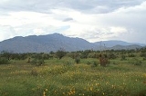
The
Rincon Mountains are a significant mountain range east of Tucson,
Pima County-2010:Whereas according to the 2010 U.S. Census Bureau:*74.3% White*3.5% Black*3.3% Native American*2.6% Asian*0.2% Native Hawaiian or Pacific Islander*3.7% Two or more races*12.4% Other races*34.6% Hispanic or Latino -2000:...
,
ArizonaArizona ; is a state located in the southwestern region of the United States. It is also part of the western United States and the mountain west. The capital and largest city is Phoenix...
, in the
United StatesThe United States of America is a federal constitutional republic comprising fifty states and a federal district...
. The Rincon Mountains are one of five mountain ranges surrounding the Tucson valley. The other ranges include the most prominent, the
Santa Catalina MountainsThe Santa Catalina Mountains, commonly referred to as the Catalina Mountains, are located north, and northeast of Tucson, Arizona, United States, on Tucson's north perimeter. The mountain range is the most prominent in the Tucson area, with the highest average elevation...
to the north, the
Santa Rita MountainsThe Santa Rita Mountains, located about 65 km southeast of Tucson, Arizona, extend 42 km from north to south, then trending southeast. They merge again southeastwards into the Patagonia Mountains, trending northwest by southeast...
to the south, the
Tucson MountainsThe Tucson Mountains are a minor mountain range west of Tucson, Arizona. The Tucson Mountains, including Wasson Peak, are one of four notable mountain ranges surrounding the Tucson valley...
to the west, and the
Tortolita MountainsThe Tortolita Mountains are a minor mountain range located northwest of Tucson, Arizona, USA. With a peak elevation of 4,652 feet , the Tortolita Mountains are situated at the northern boundaries of Oro Valley and Marana, two suburbs of Tucson...
to the northwest.
Redington PassRedington Pass is a high mountain pass between the Santa Catalina Mountains and the Rincons in northeast Pima County, Arizona. It is located just east of Tucson...
separates the Rincon Mountains from the Santa Catalina Mountains. The Rincon Mountains are generally less rugged than the Santa Catalina Mountains and Santa Rita Mountains. The Rincon Mountains are also included in the
Madrean sky islandThe Madrean Sky Islands are enclaves of Madrean pine-oak woodlands, found at higher elevations in a complex of small mountain ranges in southern and southeastern Arizona, southwestern New Mexico, and northwestern Mexico. The sky islands are surrounded at lower elevations by the Sonoran and...
mountain ranges of southeast Arizona, extreme southwest
New MexicoNew Mexico is a state located in the southwest and western regions of the United States. New Mexico is also usually considered one of the Mountain States. With a population density of 16 per square mile, New Mexico is the sixth-most sparsely inhabited U.S...
, and northern
SonoraSonora officially Estado Libre y Soberano de Sonora is one of the 31 states which, with the Federal District, comprise the 32 Federal Entities of Mexico. It is divided into 72 municipalities; the capital city is Hermosillo....
Mexico.
Rincón is
SpanishSpanish , also known as Castilian , is a Romance language in the Ibero-Romance group that evolved from several languages and dialects in central-northern Iberia around the 9th century and gradually spread with the expansion of the Kingdom of Castile into central and southern Iberia during the...
for
corner, denoting the primary shape of the mountain range. Mica Mountain (8,664 feet), the high-point of the Rincons forms the apex, with Rincon Peak (8,482 feet) forming the southern point, and Tanque Verde Peak forming the western point of the corner, along an arc-shaped ridge, the Tanque Verde Ridge. The interior of the corner is Rincon Valley (south and west of Mica Mountain), primarily former
ranchA ranch is an area of landscape, including various structures, given primarily to the practice of ranching, the practice of raising grazing livestock such as cattle or sheep for meat or wool. The word most often applies to livestock-raising operations in the western United States and Canada, though...
land currently being converted to
tract housingTract housing is a style of housing development in which multiple similar homes are built on a tract of land which is subdivided into individual small lots...
. Colossal Cave county park, a
limestoneLimestone is a sedimentary rock composed largely of the minerals calcite and aragonite, which are different crystal forms of calcium carbonate . Many limestones are composed from skeletal fragments of marine organisms such as coral or foraminifera....
caveA cave or cavern is a natural underground space large enough for a human to enter. The term applies to natural cavities some part of which is in total darkness. The word cave also includes smaller spaces like rock shelters, sea caves, and grottos.Speleology is the science of exploration and study...
and popular destination, is located on the east end of the Rincon Valley, north of the community of
VailVail is a census-designated place in Pima County, Arizona, United States. The population was 10,208 at the 2010 census. The area is known for the nearby Colossal Cave, a large cave system, and the Rincon Mountains District of Saguaro National Park, a top tourism spot within Arizona.Vail was...
.
East of the
Rincons are the
Little Rincon MountainsThe Little Rincon Mountains are a small range of mountains, lying to the east of the Rincon Mountains, at Tucson, of eastern Pima County, Arizona. The range is located in northwest Cochise County and is part of the western border of the San Pedro River and Valley, the major valley and river of...
. Between these two ranges is Happy Valley, a popular destination for locals for
campingCamping is an outdoor recreational activity. The participants leave urban areas, their home region, or civilization and enjoy nature while spending one or several nights outdoors, usually at a campsite. Camping may involve the use of a tent, caravan, motorhome, cabin, a primitive structure, or no...
,
huntingHunting is the practice of pursuing any living thing, usually wildlife, for food, recreation, or trade. In present-day use, the term refers to lawful hunting, as distinguished from poaching, which is the killing, trapping or capture of the hunted species contrary to applicable law...
, and
off-roadingOff-roading is a term for driving a vehicle on unsurfaced roads or tracks, made of materials such as sand, gravel, riverbeds, mud, snow, rocks, and other natural terrain.-Off-road vehicle:...
. Farther east is the
San Pedro RiverSan Pedro River is a northward-flowing stream originating about ten miles south of Sierra Vista, Arizona near Cananea, Sonora, Mexico. It is one of only two rivers which flow north from Mexico into the United States. The river flows north through Cochise County, Pima County, Graham County, and...
of the
San Pedro ValleyThe San Pedro Valley of western Cochise County Arizona is a 50 mile long, mostly north-south valley, trending northwesterly. It drains from Sierra Vista Southeast north towards I-10, Benson, and the southeast of the Rincon Mountains....
, a
holoceneThe Holocene is a geological epoch which began at the end of the Pleistocene and continues to the present. The Holocene is part of the Quaternary period. Its name comes from the Greek words and , meaning "entirely recent"...
palaeontology region.
South of the Rincon Mountains, beyond Rincon Valley is the Cienega Creek and
Interstate 10In the U.S. state of Arizona, Interstate 10, the major east–west Interstate Highway in the southern United States, runs east from California, enters Arizona and continues through Phoenix and Tucson and exits at the border with New Mexico.-Route description:...
.
Most of the Rincon Mountains are within
Saguaro National ParkSaguaro National Park, located in southern Arizona, is part of the United States National Park System.-Overview:The park is divided into two sections, called districts, lying approximately east and west of the center of the city of Tucson, Arizona. The total area in 2010 was of which is...
, or in the Rincon Mountain Wilderness, 32°14′50"N 110°28′02"W, of the
Coronado National ForestThe Coronado National Forest includes an area of about 1.78 million acres spread throughout mountain ranges in southeastern Arizona and southwestern New Mexico....
.
Trails
The majority of the range is off-limits to motorized & bicycle travel. The mountains can be accessed on foot or horseback by the following routes:
- East Side
- Turkey Creek Trail
- Miller Creek Trail
- North Side
- Italian Ranch (Italian Springs) Trail
- Espiritu Creek Trail (inaccessible - dense overgrowth)
- West Side
- Douglas Springs Trail
- Tanque Verde Ridge Trail
- South Side
- Madrona/Rincon Peak Trail (inaccessible - trailhead located on private land)
The
Arizona TrailThe Arizona National Scenic Trail is a National Scenic Trail from Mexico to Utah that traverses the whole north-south length of Arizona. The trail begins at the Coronado National Memorial near the US-Mexico border and moves north through parts of the Huachuca, Santa Rita, and Rincon Mountains; it...
passes through the Rincons, entering from the north by the Italian Ranch trail, and southeast by the Miller Creek Trail
See also
Further reading
- The Mountains Next Door by Janice Emily Bowers
- Papers of the Manning Family, 1860-2001 (University of Arizona Library Special Collections)
- "Flora and Vegetation of the Rincon Mountains, Pima County, Arizona", by Janice Emily Bowers
- "Fire History of the Rincon Mountain Wilderness, Saguaro National Monument" by Baisan, Christopher
External links