
Germany Valley
Encyclopedia
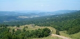
Germany Valley is a scenic upland valley high in the Allegheny Mountains
of eastern West Virginia
originally settled by German (including Pennsylvania Dutch
) farmers in the mid-18th Century. It is today a part of the Spruce Knob-Seneca Rocks National Recreation Area
of the Monongahela National Forest
, although much ownership of the Valley remains in private hands.
The Valley is noted for its extensive karst
and cave
development, with dozens of caves and cave systems having been formally documented by enthusiasts. The area was made a National Natural Landmark
, the Germany Valley Karst Areahttp://www.nature.nps.gov/nnl/site.cfm?Site=GEVA-WV, in 1973 by the National Park Service
. The NPS cited it as "one of the largest cove or intermountain karst areas in the country, unique because all the ground water recharge and solution activities are linked with precipitation within the cove."
. The Valley floor is at an elevation of approximately 2100 feet (640 m) with the surrounding mountaintops about 500 to 1200 feet (150–370 meters) higher. The Valley is about 10 miles (16.1 km) long and 2.5 miles (4 km) wide with a general northeast to southwest orientation. The Valley is defined on the east by North Fork Mountain
and on the west by the River Knobs
.
Motorized traffic may gain access to the valley from the west by either Riverton Gap (via the town of Riverton
) or Hinkle Gap, through which Root Run and Mill Creek
, respectively, drain it. The southernmost Valley is also slightly entered, via Judy Gap, where a popular overlook is located along U.S. Route 33
just west of Franklin, West Virginia
. Seneca Rocks
rise near the northern end of the Valley.
Many of the named features in or near the Valley reflect old family names of the original settlers: Judy Gap, Bennett Gap, Teter Gap, and Harper Gap; also Bland Hills, Dolly Ridge, Harman Knob, Harper Knob, Mallow Knob, and Ketterman Knob.
in 1761. John Justus Hinkle, Sr (1705/6 - 1778) and his wife Maria Magdelena Eschman (1710–1798), with their twelve children and their own families, came for the inexpensive farm land and relative freedom from Indian attacks. They were also attracted by the fertile limestone soils and gently rolling bottomland. They were soon joined by the Teters and by Pennsylvania Dutch families, some having migrated southwest following the ridges and through the "Valley of Virginia
" from Pennsylvania
's Lebanon
and Lancaster counties
. A few German families also moved west from Spotsylvania County, Virginia
. These settlers brought the familiar custom of placing hex sign
s on their barns (perhaps the only section of West Virginia where these signs were once found.)
Indians were by no means absent from the region, however, as the famous Seneca Trail
(or Great Indian Warpath) passed near the Valley and the nearby British positions at Fort Seybert
and Fort Upper Tract had been destroyed (1758) in Indian uprisings led by Killbuck
, a Delaware
chieftain. Four years later, a stockade (Hinkle's Fort) was built by the men of the Hinkle family to protect these border settlements from additional Indian raids. At the time of the Revolution
, the fort became headquarters and training ground for the North Fork Military Company which was organized by the sons and sons-in-law of John Justus Hinkle, Sr. The fort is long since gone, but a large arrowhead-shaped stone monument enclosed by an iron fence marks its former site. (This is along the valley road leading east from Riverton).
These traditional farming families long retained their language and "old country" customs and so the Valley became known as "German Settlement" or "Germany Valley". At about the same time, many Scotch-Irish families also migrated from the north and bought land in Pendleton County, including Germany Valley. Although the community prospered, it long remained isolated and its agricultural economy continued to be based predominantly on forage crops
, cattle
, horses, milk cows, and sheep. The farms remained largely self-sufficient because the poor roads and absence of turnpikes made it difficult to reach larger markets in adjacent areas.
In June 1781, after a difficult passage over North Fork Mountain
, the Valley was evangelized by Bishop Francis Asbury
. Asbury was one of the two original Methodist missionaries in the United States. In his Journal Asbury records preaching to about ninety "Dutch folk" who, in his words, "appeared to feel the word". The Bishop records a June 21 visit to what for over 150 years was known as "Asbury Cave" — now Stratosphere Balloon Cave. He also describes the large spring (Judy Spring) found in the Valley.
, the communities of the upper North Fork, including Germany Valley, and Franklin, were strongly Confederate in their sympathies, although nearby Seneca Rocks and the lower South Branch Valley were generally northern in persuasion. Pendleton County was a border area like many unprotected by either Federal troops or the Confederates. Such divided counties, then the rule in central West Virginia, were torn by internal strife and uncertainty and border county "wars" among various partisan groups were continuous. County governments often ceased to operate altogether. Many of the Valley's men joined local partisan units such as the Pendleton Scouts, Pendleton Rifles, and Dixie Boys and fought for the Confederacy. In northern Pendleton County, the Swamp Dragons, or "Swamps", were equally strong defenders of the Union. Clashes between these units were frequent and bitter, with members of the same families often contending against one another. Raids by Union army units and Union partisans such as the Swamps occurred several times in the Valley during the war years.
Originally, the coves and moist slopes of the Valley were covered with fine timber stands, notably including black walnut
. Much of the virgin forest was cut to supply local needs, and often good, commercial-grade logs were simply burned in land-clearing operations. Later, in the 19th Century, professional lumbermen became interested and the remaining forests were harvested, sawn, and taken by horse and wagon to the Baltimore and Ohio Railroad
at Keyser
, some 30 miles (48.3 km) away. In the northwestern part of the county, much of the timber was hauled by logging railroad to the Parsons Pulp and Lumber Company mill at Horton in Randolph County
. Due to the prevailing isolation and poor transportation system, large saw mills were not found in the area during the last part of the 19th Century. Small sash and circular saw mills
, however, were present.
limestones at the culmination of the Wills Mountain
anticline
. The Valley is formed within the eastern and western limbs of this eroded anticline (fold), which are represented by North Fork Mountain
and the River Knobs
, respectively. Both North Fork Mountain and the River Knobs are classed as homoclinal ridges and Germany Valley itself as a homoclinal valley.
limestone which, where exposed at the surface, has a tendency to erode with deep vertical fissures. Cave development is in places spectacular often producing large passages and capacious rooms. The numerous sink holes, sinking streams, surface stone, and irregular ridges apparent throughout the Valley have made it a frequently visited and celebrated venue for the caving
community.
New Market limestone is rich in calcium carbonate
, but also has significant amounts of potassium
and phosphorus
which, along with its low silicon content, makes it very popular with quarry
men. These ingredients make the resulting lime commercially valuable for fertilizing farm pasture land and lawns and for steel and coal production. In the Valley, the limestone attracted the Greer Limestone Plant, a part of Greer Industries, Inc., which has done a thriving business since 19??, although not without controversy with regard to its environmental impact (see below).
The entrance to Hellhole is owned by a private landowner who has never wished to sell the land around it. The quarry, immediately to the west of the cave entrance, is operated by Greer Limestone Company (owned by West Virginia businessman and politician John Raese
). Greer leased the entrance to Hellhole from the landowner in 1986, and as the leasee, soon began to deny most access to the cave. Greer did allow the West Virginia Division of Natural Resources
(WV DNR) to conduct bi-annual trips into the cave for the purpose of counting the populations of endangered bat species. In the 1990s, at urging of the WV DNR, Greer also began to allow limited exploration and mapping of the cave (one or two trips per year).
In 1995 an extension to the cave ("Krause Hall") was discovered in the extreme northwest portion of the cave. In 1996 one of the deepest sections of the cave was explored at over 400 feet (121.9 m) below the entrance elevation. In 1997, a break-through discovery off this area extended the known extent of Hellhole well to the south of its originally known range. This showed that the historically known portions of Hellhole were a mere side passage to a much larger cave system.
By this time the U.S. Fish and Wildlife Service had recognized Hellhole as a critical habitat for two species of endangered (and federally protected) bat, the Indiana bat
(Myotis sodalis) and the Virginia big-eared bat (Corynorhinus townsendii virginianus). It was known that about 45% of the world's estimated 20,000 remaining Virginia big-eared bats hibernate in Hellhole. Greer had responded by establishing a no-work buffer zone of 250 feet (76.2 m) and a no-blast buffer zone of 500 feet (152.4 m) from the nearest known passage in Hellhole. That word "known" proved to be the bone of contention.
The reason Hellhole is such an important cave for these bats is its unusually low ambient air temperature. Most caves in West Virginia average around 57 °F (13.9 °C). Hellhole averages around 47 degrees. This cold temperature is critical for these species survival. The cave remains cool because it functions as a natural cold air trap. Located in the middle of an enclosed valley, and having only one entrance, all cold air flowing off North Fork Mountain in winter collects in the cave. Cold air goes down, and having no place to escape, stays down, filling the cave's massive passages. This cold air collecting phenomenon is what makes the cave so vulnerable to accidental damage from quarrying activities. If this natural cold air trap were to be breached at an elevation lower than the entrance, the cold air would quickly flow out, and the cave would likely no longer function as a bat hibernaculum, at least for these particular species.
With the advent of the 1997 discoveries, Greer was threatened with the potential loss of a valuable section of limestone to the endangered species habitat. From that point forward Greer permitted no further exploration of Hellhole. Cavers perceived that because the quarry did not wish to lose any further areas of limestone to bat habitat, it effectively began to impede further exploration and, therefore, "knowledge" of the cave's extent.
In 2000, Greer announced its intention to seek a renewal permit to continue its quarrying operations in Germany Valley and to extend them to the north and south of the existing open pit. This request was filed publicly, as required by the West Virginia Department of Environmental Protection (WV DEP) requirements, and it ignited a furor among Virginia and West Virginia cavers who began petitioning officials and started a letter campaign. In their view, it was highly likely that quarry operations, conducted with a lack of knowledge regarding the cave's complete extent, would in time penetrate some portion of the cave. Such an event, it was argued, would have disastrous effects upon the suitability of the cave as an endangered bat species hibernaculum. In 2002—after prolonged negotiations with Greer—the USFWS, West Virginia Department of Natural Resources (WV DNR), WV DEP, caving organizations and local landowners, the Germany Valley Karst Survey (GVKS) was formally contracted to survey the extent of the Hellhole cave system. In accordance with USFWS requirements regarding endangered bats, all annual survey activities must be completed within a 16-week window during the summer months. Since that time, the known extent of the cave has expanded to 24.9 mapped miles (40.1 kilometers) and 519 feet (158.2 m) of depth. The GVKS-Greer contract ended in 2007.
Allegheny Mountains
The Allegheny Mountain Range , also spelled Alleghany, Allegany and, informally, the Alleghenies, is part of the vast Appalachian Mountain Range of the eastern United States and Canada...
of eastern West Virginia
West Virginia
West Virginia is a state in the Appalachian and Southeastern regions of the United States, bordered by Virginia to the southeast, Kentucky to the southwest, Ohio to the northwest, Pennsylvania to the northeast and Maryland to the east...
originally settled by German (including Pennsylvania Dutch
Pennsylvania Dutch
Pennsylvania Dutch refers to immigrants and their descendants from southwestern Germany and Switzerland who settled in Pennsylvania in the 17th and 18th centuries...
) farmers in the mid-18th Century. It is today a part of the Spruce Knob-Seneca Rocks National Recreation Area
Spruce Knob-Seneca Rocks National Recreation Area
Spruce Knob-Seneca Rocks National Recreation Area is a U.S. National Recreation Area located within the Monongahela National Forest of eastern West Virginia, USA.The National Recreation Area protects three prominent West Virginia landmarks:...
of the Monongahela National Forest
Monongahela National Forest
The Monongahela National Forest is a national forest located in the Allegheny Mountains of eastern West Virginia, USA. It protects over of federally-owned land within a proclamation boundary that includes much of the Potomac Highlands Region and portions of 10 counties.The MNF includes some...
, although much ownership of the Valley remains in private hands.
The Valley is noted for its extensive karst
KARST
Kilometer-square Area Radio Synthesis Telescope is a Chinese telescope project to which FAST is a forerunner. KARST is a set of large spherical reflectors on karst landforms, which are bowlshaped limestone sinkholes named after the Kras region in Slovenia and Northern Italy. It will consist of...
and cave
Cave
A cave or cavern is a natural underground space large enough for a human to enter. The term applies to natural cavities some part of which is in total darkness. The word cave also includes smaller spaces like rock shelters, sea caves, and grottos.Speleology is the science of exploration and study...
development, with dozens of caves and cave systems having been formally documented by enthusiasts. The area was made a National Natural Landmark
National Natural Landmark
The National Natural Landmark program recognizes and encourages the conservation of outstanding examples of the natural history of the United States. It is the only natural areas program of national scope that identifies and recognizes the best examples of biological and geological features in...
, the Germany Valley Karst Areahttp://www.nature.nps.gov/nnl/site.cfm?Site=GEVA-WV, in 1973 by the National Park Service
National Park Service
The National Park Service is the U.S. federal agency that manages all national parks, many national monuments, and other conservation and historical properties with various title designations...
. The NPS cited it as "one of the largest cove or intermountain karst areas in the country, unique because all the ground water recharge and solution activities are linked with precipitation within the cove."
Geography
Germany Valley is situated in the upper reaches of the North Fork South Branch Potomac River in northeastern Pendleton County, West VirginiaPendleton County, West Virginia
As of the census of 2000, there were 8,196 people, 3,350 households, and 2,355 families residing in the county. The population density was 12 people per square mile . There were 5,102 housing units at an average density of 7 per square mile...
. The Valley floor is at an elevation of approximately 2100 feet (640 m) with the surrounding mountaintops about 500 to 1200 feet (150–370 meters) higher. The Valley is about 10 miles (16.1 km) long and 2.5 miles (4 km) wide with a general northeast to southwest orientation. The Valley is defined on the east by North Fork Mountain
North Fork Mountain
North Fork Mountain is a quartzite-capped mountain ridge in the Ridge and Valley physiographic province of the Allegheny Mountains of eastern West Virginia, USA...
and on the west by the River Knobs
River Knobs (West Virginia)
For other "River Knobs", see River Knobs .The River Knobs — formerly known as East Seneca Ridge — are a ridge and series of knobs in western Pendleton County, West Virginia, USA, along a stretch of the North Fork South Branch Potomac River...
.
Motorized traffic may gain access to the valley from the west by either Riverton Gap (via the town of Riverton
Riverton, West Virginia
Riverton is an unincorporated town on the North Fork South Branch Potomac River in Pendleton County, West Virginia, USA. Riverton lies along U.S. Highway 33/West Virginia Route 28 in the Monongahela National Forest....
) or Hinkle Gap, through which Root Run and Mill Creek
Mill Creek (North Fork South Branch Potomac River)
Mill Creek is a tributary stream of the North Fork South Branch Potomac River in Pendleton County, West Virginia. Mill Creek rises on the western flanks of North Fork Mountain and from there, flows north through Germany Valley. Its confluence with the North Fork lies at Hinkle Gap between Germany...
, respectively, drain it. The southernmost Valley is also slightly entered, via Judy Gap, where a popular overlook is located along U.S. Route 33
U.S. Route 33
U.S. Route 33 is a United States federal highway that runs northwest-southeast for 709 miles from northern Indiana to Richmond, Virginia, passing through Ohio and West Virginia en route. Although most odd-numbered U.S...
just west of Franklin, West Virginia
Franklin, West Virginia
Franklin is a town in Pendleton County, West Virginia, United States. The population was 797 at the 2000 census. It is the county seat of Pendleton County...
. Seneca Rocks
Seneca Rocks
Seneca Rocks is a large crag and local landmark in Pendleton County in the Eastern Panhandle of West Virginia, USA. It is easily visible and accessible along West Virginia Route 28 near U.S. Route 33 in the Spruce Knob-Seneca Rocks National Recreation Area of the Monongahela National Forest...
rise near the northern end of the Valley.
Many of the named features in or near the Valley reflect old family names of the original settlers: Judy Gap, Bennett Gap, Teter Gap, and Harper Gap; also Bland Hills, Dolly Ridge, Harman Knob, Harper Knob, Mallow Knob, and Ketterman Knob.
18th Century
Germany Valley is named for the German families that were its earliest settlers. The first to arrive was the Hinkle (originally Henckel) family, which migrated from North CarolinaNorth Carolina
North Carolina is a state located in the southeastern United States. The state borders South Carolina and Georgia to the south, Tennessee to the west and Virginia to the north. North Carolina contains 100 counties. Its capital is Raleigh, and its largest city is Charlotte...
in 1761. John Justus Hinkle, Sr (1705/6 - 1778) and his wife Maria Magdelena Eschman (1710–1798), with their twelve children and their own families, came for the inexpensive farm land and relative freedom from Indian attacks. They were also attracted by the fertile limestone soils and gently rolling bottomland. They were soon joined by the Teters and by Pennsylvania Dutch families, some having migrated southwest following the ridges and through the "Valley of Virginia
Great Appalachian Valley
The Great Valley, also called the Great Appalachian Valley or Great Valley Region, is one of the major landform features of eastern North America. It is a gigantic trough — a chain of valley lowlands — and the central feature of the Appalachian Mountain system...
" from Pennsylvania
Pennsylvania
The Commonwealth of Pennsylvania is a U.S. state that is located in the Northeastern and Mid-Atlantic regions of the United States. The state borders Delaware and Maryland to the south, West Virginia to the southwest, Ohio to the west, New York and Ontario, Canada, to the north, and New Jersey to...
's Lebanon
Lebanon County, Pennsylvania
As of the census of 2000, there were 120,327 people and 32,771 families residing in the county. The population density was 332 people per square mile . There were 49,320 housing units at an average density of 136 per square mile...
and Lancaster counties
Lancaster County, Pennsylvania
Lancaster County, known as the Garden Spot of America or Pennsylvania Dutch Country, is a county located in the southeastern part of the Commonwealth of Pennsylvania, in the United States. As of 2010 the population was 519,445. Lancaster County forms the Lancaster Metropolitan Statistical Area, the...
. A few German families also moved west from Spotsylvania County, Virginia
Spotsylvania County, Virginia
As of the census of 2000, there were 90,395 people, 31,308 households, and 24,639 families residing in the county. The population density was 226 people per square mile . There were 33,329 housing units at an average density of 83 per square mile...
. These settlers brought the familiar custom of placing hex sign
Hex sign
Hex signs are a form of Pennsylvania Dutch folk art, related to fraktur, found in the Fancy Dutch tradition in Pennsylvania Dutch Country. Barn paintings, usually in the form of "stars in circles," grew out of the fraktur and folk art traditions about 1850 when barns first started to be painted in...
s on their barns (perhaps the only section of West Virginia where these signs were once found.)
Indians were by no means absent from the region, however, as the famous Seneca Trail
Great Indian Warpath
The Great Indian Warpath — also known as the Great Indian War and Trading Path, or the Seneca Trail — was that part of the network of trails in eastern North America developed and used by Native Americans which ran through the Great Appalachian Valley...
(or Great Indian Warpath) passed near the Valley and the nearby British positions at Fort Seybert
Fort Seybert
Fort Seybert was an 18th century frontier fort in the Allegheny Mountains in what is now Pendleton County, West Virginia, USA. In a 1758 surprise raid occasioned by the French and Indian War , most of the 30 white settlers sheltering there were massacred by Shawnee and Delaware warriors and the...
and Fort Upper Tract had been destroyed (1758) in Indian uprisings led by Killbuck
Bemino
Bemino — known as John Killbuck, Sr to white settlers — was a renowned medicine man and war leader of Shawnee and Delaware warriors during the French and Indian War . He was a son of Netawatwees, at one time principal chief of the Delaware, and his own son was Gelelemend , a Delaware chief during...
, a Delaware
Lenape
The Lenape are an Algonquian group of Native Americans of the Northeastern Woodlands. They are also called Delaware Indians. As a result of the American Revolutionary War and later Indian removals from the eastern United States, today the main groups live in Canada, where they are enrolled in the...
chieftain. Four years later, a stockade (Hinkle's Fort) was built by the men of the Hinkle family to protect these border settlements from additional Indian raids. At the time of the Revolution
American Revolutionary War
The American Revolutionary War , the American War of Independence, or simply the Revolutionary War, began as a war between the Kingdom of Great Britain and thirteen British colonies in North America, and ended in a global war between several European great powers.The war was the result of the...
, the fort became headquarters and training ground for the North Fork Military Company which was organized by the sons and sons-in-law of John Justus Hinkle, Sr. The fort is long since gone, but a large arrowhead-shaped stone monument enclosed by an iron fence marks its former site. (This is along the valley road leading east from Riverton).
These traditional farming families long retained their language and "old country" customs and so the Valley became known as "German Settlement" or "Germany Valley". At about the same time, many Scotch-Irish families also migrated from the north and bought land in Pendleton County, including Germany Valley. Although the community prospered, it long remained isolated and its agricultural economy continued to be based predominantly on forage crops
Fodder
Fodder or animal feed is any agricultural foodstuff used specifically to feed domesticated livestock such as cattle, goats, sheep, horses, chickens and pigs. Most animal feed is from plants but some is of animal origin...
, cattle
Cattle
Cattle are the most common type of large domesticated ungulates. They are a prominent modern member of the subfamily Bovinae, are the most widespread species of the genus Bos, and are most commonly classified collectively as Bos primigenius...
, horses, milk cows, and sheep. The farms remained largely self-sufficient because the poor roads and absence of turnpikes made it difficult to reach larger markets in adjacent areas.
In June 1781, after a difficult passage over North Fork Mountain
North Fork Mountain
North Fork Mountain is a quartzite-capped mountain ridge in the Ridge and Valley physiographic province of the Allegheny Mountains of eastern West Virginia, USA...
, the Valley was evangelized by Bishop Francis Asbury
Francis Asbury
Bishop Francis Asbury was one of the first two bishops of the Methodist Episcopal Church, now The United Methodist Church in the United States...
. Asbury was one of the two original Methodist missionaries in the United States. In his Journal Asbury records preaching to about ninety "Dutch folk" who, in his words, "appeared to feel the word". The Bishop records a June 21 visit to what for over 150 years was known as "Asbury Cave" — now Stratosphere Balloon Cave. He also describes the large spring (Judy Spring) found in the Valley.
19th Century
At the time of the American Civil WarAmerican Civil War
The American Civil War was a civil war fought in the United States of America. In response to the election of Abraham Lincoln as President of the United States, 11 southern slave states declared their secession from the United States and formed the Confederate States of America ; the other 25...
, the communities of the upper North Fork, including Germany Valley, and Franklin, were strongly Confederate in their sympathies, although nearby Seneca Rocks and the lower South Branch Valley were generally northern in persuasion. Pendleton County was a border area like many unprotected by either Federal troops or the Confederates. Such divided counties, then the rule in central West Virginia, were torn by internal strife and uncertainty and border county "wars" among various partisan groups were continuous. County governments often ceased to operate altogether. Many of the Valley's men joined local partisan units such as the Pendleton Scouts, Pendleton Rifles, and Dixie Boys and fought for the Confederacy. In northern Pendleton County, the Swamp Dragons, or "Swamps", were equally strong defenders of the Union. Clashes between these units were frequent and bitter, with members of the same families often contending against one another. Raids by Union army units and Union partisans such as the Swamps occurred several times in the Valley during the war years.
Originally, the coves and moist slopes of the Valley were covered with fine timber stands, notably including black walnut
Black Walnut
Juglans nigra, the Eastern Black walnut, is a species of flowering tree in the hickory family, Juglandaceae, that is native to eastern North America. It grows mostly in riparian zones, from southern Ontario, west to southeast South Dakota, south to Georgia, northern Florida and southwest to central...
. Much of the virgin forest was cut to supply local needs, and often good, commercial-grade logs were simply burned in land-clearing operations. Later, in the 19th Century, professional lumbermen became interested and the remaining forests were harvested, sawn, and taken by horse and wagon to the Baltimore and Ohio Railroad
Baltimore and Ohio Railroad
The Baltimore and Ohio Railroad was one of the oldest railroads in the United States and the first common carrier railroad. It came into being mostly because the city of Baltimore wanted to compete with the newly constructed Erie Canal and another canal being proposed by Pennsylvania, which...
at Keyser
Keyser, West Virginia
Keyser is a city in and the county seat of Mineral County, West Virginia, United States. It is part of the Cumberland, MD-WV Metropolitan Statistical Area. The population was 5,303 at the 2000 census.- History :...
, some 30 miles (48.3 km) away. In the northwestern part of the county, much of the timber was hauled by logging railroad to the Parsons Pulp and Lumber Company mill at Horton in Randolph County
Randolph County, West Virginia
As of the census of 2000, there were 28,262 people, 11,072 households, and 7,661 families residing in the county. The population density was 27 people per square mile . There were 13,478 housing units at an average density of 13 per square mile...
. Due to the prevailing isolation and poor transportation system, large saw mills were not found in the area during the last part of the 19th Century. Small sash and circular saw mills
Circular saw
The circular saw is a machine using a toothed metal cutting disc or blade. The term is also loosely used for the blade itself. The blade is a tool for cutting wood or other materials and may be hand-held or table-mounted. It can also be used to make narrow slots...
, however, were present.
Geology
Germany Valley is characterized by OrdovicianOrdovician
The Ordovician is a geologic period and system, the second of six of the Paleozoic Era, and covers the time between 488.3±1.7 to 443.7±1.5 million years ago . It follows the Cambrian Period and is followed by the Silurian Period...
limestones at the culmination of the Wills Mountain
Wills Mountain
Wills Mountain is a quartzite-capped ridge in the Ridge and Valley physiographic province of the Appalachian Mountains in Pennsylvania and Maryland, USA, extending from near Bedford, Pennsylvania to near Cumberland, Maryland...
anticline
Anticline
In structural geology, an anticline is a fold that is convex up and has its oldest beds at its core. The term is not to be confused with antiform, which is a purely descriptive term for any fold that is convex up. Therefore if age relationships In structural geology, an anticline is a fold that is...
. The Valley is formed within the eastern and western limbs of this eroded anticline (fold), which are represented by North Fork Mountain
North Fork Mountain
North Fork Mountain is a quartzite-capped mountain ridge in the Ridge and Valley physiographic province of the Allegheny Mountains of eastern West Virginia, USA...
and the River Knobs
River Knobs (West Virginia)
For other "River Knobs", see River Knobs .The River Knobs — formerly known as East Seneca Ridge — are a ridge and series of knobs in western Pendleton County, West Virginia, USA, along a stretch of the North Fork South Branch Potomac River...
, respectively. Both North Fork Mountain and the River Knobs are classed as homoclinal ridges and Germany Valley itself as a homoclinal valley.
Cave and karst features
Germany Valley is famously underlain by New Market limestone bedrock, a pale grey limestone of the St. Paul Group of OrdovicianOrdovician
The Ordovician is a geologic period and system, the second of six of the Paleozoic Era, and covers the time between 488.3±1.7 to 443.7±1.5 million years ago . It follows the Cambrian Period and is followed by the Silurian Period...
limestone which, where exposed at the surface, has a tendency to erode with deep vertical fissures. Cave development is in places spectacular often producing large passages and capacious rooms. The numerous sink holes, sinking streams, surface stone, and irregular ridges apparent throughout the Valley have made it a frequently visited and celebrated venue for the caving
Caving
Caving—also occasionally known as spelunking in the United States and potholing in the United Kingdom—is the recreational pastime of exploring wild cave systems...
community.
New Market limestone is rich in calcium carbonate
Calcium carbonate
Calcium carbonate is a chemical compound with the formula CaCO3. It is a common substance found in rocks in all parts of the world, and is the main component of shells of marine organisms, snails, coal balls, pearls, and eggshells. Calcium carbonate is the active ingredient in agricultural lime,...
, but also has significant amounts of potassium
Potassium
Potassium is the chemical element with the symbol K and atomic number 19. Elemental potassium is a soft silvery-white alkali metal that oxidizes rapidly in air and is very reactive with water, generating sufficient heat to ignite the hydrogen emitted in the reaction.Potassium and sodium are...
and phosphorus
Phosphorus
Phosphorus is the chemical element that has the symbol P and atomic number 15. A multivalent nonmetal of the nitrogen group, phosphorus as a mineral is almost always present in its maximally oxidized state, as inorganic phosphate rocks...
which, along with its low silicon content, makes it very popular with quarry
Quarry
A quarry is a type of open-pit mine from which rock or minerals are extracted. Quarries are generally used for extracting building materials, such as dimension stone, construction aggregate, riprap, sand, and gravel. They are often collocated with concrete and asphalt plants due to the requirement...
men. These ingredients make the resulting lime commercially valuable for fertilizing farm pasture land and lawns and for steel and coal production. In the Valley, the limestone attracted the Greer Limestone Plant, a part of Greer Industries, Inc., which has done a thriving business since 19??, although not without controversy with regard to its environmental impact (see below).
Notable caves
- Seneca Caverns is a commercial caveShow caveShow caves — also called tourist caves, public caves, and in the United States, commercial caves — are caves that are managed by a government or commercial organization and made accessible to the general public, usually for an entrance fee...
discovered in Germany Valley by settler Laven Teter in about 1780, although allegedly the SenecaSeneca nationThe Seneca are a group of indigenous people native to North America. They were the nation located farthest to the west within the Six Nations or Iroquois League in New York before the American Revolution. While exact population figures are unknown, approximately 15,000 to 25,000 Seneca live in...
Indians had utilized the cave before that. It has been commercialized since 1928 and electrified since 1930. Visitors are led along a 0.75 mile (1.2 kilometer) prepared trail and descend as deep as 165 feet (50.3 m) below the surface, while the numerous named speleothemSpeleothemA speleothem , commonly known as a cave formation, is a secondary mineral deposit formed in a cave. Speleothems are typically formed in limestone or dolostone solutional caves.-Origin and composition:...
s (‘Mirror Lake", "Niagara Falls Frozen Over", "Fairyland", "The Capitol Dome" etc.) are highlighted.
- Stratosphere Balloon Cave, about 200 yards (182.9 m) south of Seneca Caverns, is named for a large ribbon flowstone, 18 feet (5.5 m) in diameter and reaching 25 feet (7.6 m) to the ceiling, resembling a high altitude balloonHigh altitude balloonHigh-altitude balloons are unmanned balloons, usually filled with helium or hydrogen that are released into the stratosphere, generally reaching between ....
. Stratosphere was open to the public as a commercial cave in the 1930s, but closed in 1939. It was reopened in 2006 and currently charges a fee and requires a guide, as the cave has never been electrified.
- HellholeHellholeHellhole is a large, deep and — in the caving community — fabled pit cave in Germany Valley, eastern West Virginia. It is the 11th longest cave in the United States and is home to almost half of the world's population of Virginia big-eared bats...
, along with nearby Schoolhouse Cave, is historically significant to the caving community associated with the National Speleological SocietyNational Speleological SocietyThe National Speleological Society is an organization formed in 1941 to advance the exploration, conservation, study, and understanding of caves in the United States. Originally located in Washington D.C., its current offices are in Huntsville, Alabama...
dating back to its creation (1940s). With over 28 miles (45.1 km) of passage, Hellhole is the 11th longest cave in the US and site of an important bat hibernaculumHibernaculumHibernaculum can refer to:* Hibernaculum , the location chosen by an animal for hibernation...
(home to 45% of the world's population of Virginia big-eared batCorynorhinusThe genus Corynorhinus consists of the lump-nosed bats, or American long-eared bats. Only three species occur in the genus, all occurring in North America. Members of this group were previously in the genus Plecotus. Populations of these species are generally uncommon and declining. Two...
s). It is the most extensive of several mapped caves in the area, and the deepest cave in the valley (158 m).
- Schoolhouse Cave contained saltpeterPotassium nitratePotassium nitrate is a chemical compound with the formula KNO3. It is an ionic salt of potassium ions K+ and nitrate ions NO3−.It occurs as a mineral niter and is a natural solid source of nitrogen. Its common names include saltpetre , from medieval Latin sal petræ: "stone salt" or possibly "Salt...
works supporting nearby Hinkle's Fort late in the French and Indian WarFrench and Indian WarThe French and Indian War is the common American name for the war between Great Britain and France in North America from 1754 to 1763. In 1756, the war erupted into the world-wide conflict known as the Seven Years' War and thus came to be regarded as the North American theater of that war...
(1754–63) and thus may be the second oldest saltpeter mine in the state. During the Civil War it was mined in support of Union, but not Confederate, forces (which may be unique in the state). Like nearby Hellhole, early NSSNational Speleological SocietyThe National Speleological Society is an organization formed in 1941 to advance the exploration, conservation, study, and understanding of caves in the United States. Originally located in Washington D.C., its current offices are in Huntsville, Alabama...
expeditions to Schoolhouse were very important to the pioneering cavers of the 1930s and ‘40s. It has been called a "vertical caver's paradise".
- Memorial Day Cave was discovered by cavers at the southern end of the Valley in 1999 and was first entered in 2001. The following year cavers found a 125-foot (38 m) drop into "Columbia Canyon", which proved to be a mile long. The cave is now known to be over 14 miles (22.5 kilometers) long and 430 feet (131 m) deep.
- Judy Spring, a trout stream as well as cave enterable by SCUBA divers
- Shoveleater Cave has over 4 miles of mapped passage.
- Harman Pit
- Apex Cave
- Ruddle Cave
- Harper's Pit
- Convention 2000 Cave
Greer Limestone/Hellhole bat controversy
From the 1940s, when exploration of Hellhole began, to the 1980s, cavers had mapped approximately 8.5 miles (13.7 km) of passage in the popular Hellhole system. The cave is developed in New Market Limestone, the same rock unit that is mined in the nearby open pit quarry.The entrance to Hellhole is owned by a private landowner who has never wished to sell the land around it. The quarry, immediately to the west of the cave entrance, is operated by Greer Limestone Company (owned by West Virginia businessman and politician John Raese
John Raese
John R. Raese is an American business owner and politician. He has lost campaigns to represent West Virginia in the U.S. Senate in 1984, 2006 and 2010, and a campaign for Governor of West Virginia in 1988....
). Greer leased the entrance to Hellhole from the landowner in 1986, and as the leasee, soon began to deny most access to the cave. Greer did allow the West Virginia Division of Natural Resources
West Virginia Division of Natural Resources
The West Virginia Division of Natural Resources is an agency of the government of the U.S. state of West Virginia. While formerly known as the cabinet-level Department of Natural Resources, it is now part of the West Virginia Department of Commerce...
(WV DNR) to conduct bi-annual trips into the cave for the purpose of counting the populations of endangered bat species. In the 1990s, at urging of the WV DNR, Greer also began to allow limited exploration and mapping of the cave (one or two trips per year).
In 1995 an extension to the cave ("Krause Hall") was discovered in the extreme northwest portion of the cave. In 1996 one of the deepest sections of the cave was explored at over 400 feet (121.9 m) below the entrance elevation. In 1997, a break-through discovery off this area extended the known extent of Hellhole well to the south of its originally known range. This showed that the historically known portions of Hellhole were a mere side passage to a much larger cave system.
By this time the U.S. Fish and Wildlife Service had recognized Hellhole as a critical habitat for two species of endangered (and federally protected) bat, the Indiana bat
Indiana bat
The Indiana bat is a medium-sized mouse-eared bat native to North America. It lives primarily in eastern and midwestern states and in parts of the south of the United States. The Indiana bat is gray, black, or chestnut in colour and is 1.2–2 inches and weighs about 1/4 an ounce...
(Myotis sodalis) and the Virginia big-eared bat (Corynorhinus townsendii virginianus). It was known that about 45% of the world's estimated 20,000 remaining Virginia big-eared bats hibernate in Hellhole. Greer had responded by establishing a no-work buffer zone of 250 feet (76.2 m) and a no-blast buffer zone of 500 feet (152.4 m) from the nearest known passage in Hellhole. That word "known" proved to be the bone of contention.
The reason Hellhole is such an important cave for these bats is its unusually low ambient air temperature. Most caves in West Virginia average around 57 °F (13.9 °C). Hellhole averages around 47 degrees. This cold temperature is critical for these species survival. The cave remains cool because it functions as a natural cold air trap. Located in the middle of an enclosed valley, and having only one entrance, all cold air flowing off North Fork Mountain in winter collects in the cave. Cold air goes down, and having no place to escape, stays down, filling the cave's massive passages. This cold air collecting phenomenon is what makes the cave so vulnerable to accidental damage from quarrying activities. If this natural cold air trap were to be breached at an elevation lower than the entrance, the cold air would quickly flow out, and the cave would likely no longer function as a bat hibernaculum, at least for these particular species.
With the advent of the 1997 discoveries, Greer was threatened with the potential loss of a valuable section of limestone to the endangered species habitat. From that point forward Greer permitted no further exploration of Hellhole. Cavers perceived that because the quarry did not wish to lose any further areas of limestone to bat habitat, it effectively began to impede further exploration and, therefore, "knowledge" of the cave's extent.
In 2000, Greer announced its intention to seek a renewal permit to continue its quarrying operations in Germany Valley and to extend them to the north and south of the existing open pit. This request was filed publicly, as required by the West Virginia Department of Environmental Protection (WV DEP) requirements, and it ignited a furor among Virginia and West Virginia cavers who began petitioning officials and started a letter campaign. In their view, it was highly likely that quarry operations, conducted with a lack of knowledge regarding the cave's complete extent, would in time penetrate some portion of the cave. Such an event, it was argued, would have disastrous effects upon the suitability of the cave as an endangered bat species hibernaculum. In 2002—after prolonged negotiations with Greer—the USFWS, West Virginia Department of Natural Resources (WV DNR), WV DEP, caving organizations and local landowners, the Germany Valley Karst Survey (GVKS) was formally contracted to survey the extent of the Hellhole cave system. In accordance with USFWS requirements regarding endangered bats, all annual survey activities must be completed within a 16-week window during the summer months. Since that time, the known extent of the cave has expanded to 24.9 mapped miles (40.1 kilometers) and 519 feet (158.2 m) of depth. The GVKS-Greer contract ended in 2007.
Other sources
- Ansel, William H., Jr., Frontier Forts Along the Potomac and Its Tributaries, McClain Printing CompanyMcClain Printing CompanyThe McClain Printing Company is a printing company specializing in books of West Virginia history and lore. The company was incorporated in 1958 in Parsons, West Virginia as an outgrowth of the local weekly newspaper, the Parsons Advocate.-History:...
, Parsons, West VirginiaParsons, West VirginiaThe town of Parsons is the county seat of Tucker County, West Virginia, in the United States. The population was 1,463 at the 2000 census. The mayor of Parsons is Dorothy Judy and the city administrator is Jason Myers...
, 1984; Reprinted 1995; ISBN 0961384204. - Carvell, Kenneth L., “Germany Valley”, Wonderful West Virginia Magazine, September 2000, Vol.64, No. 9, West Virginia Division of Natural ResourcesWest Virginia Division of Natural ResourcesThe West Virginia Division of Natural Resources is an agency of the government of the U.S. state of West Virginia. While formerly known as the cabinet-level Department of Natural Resources, it is now part of the West Virginia Department of Commerce...
. - Dasher, George R., (2001), Bulletin #15, The Caves and Karst of Pendleton County, West Virginia Speleological SurveyWest Virginia Speleological SurveyThe West Virginia Speleological Survey is a speleological organization and ongoing cave survey program that has gathered information and published about West Virginia caves and karst since 1967....
. - Germany Valley Karst Survey Website (Hellhole webpage)