
Parsons, West Virginia
Encyclopedia
County seat
A county seat is an administrative center, or seat of government, for a county or civil parish. The term is primarily used in the United States....
of Tucker County
Tucker County, West Virginia
As of the census of 2000, there were 7,321 people, 3,052 households, and 2,121 families residing in the county. The population density was 18 people per square mile . There were 4,634 housing units at an average density of 11 per square mile...
, West Virginia
West Virginia
West Virginia is a state in the Appalachian and Southeastern regions of the United States, bordered by Virginia to the southeast, Kentucky to the southwest, Ohio to the northwest, Pennsylvania to the northeast and Maryland to the east...
, in the United States
United States
The United States of America is a federal constitutional republic comprising fifty states and a federal district...
. The population was 1,463 at the 2000 census. The mayor of Parsons is Dorothy Judy and the city administrator is Jason Myers. There is a city council.
History
The town was named for Ward Parsons, described by one source as having once owned the land on which the town was built, and by another as having been an aged wilderness pioneer in the area.Located at Parsons and listed on the National Register of Historic Places
National Register of Historic Places
The National Register of Historic Places is the United States government's official list of districts, sites, buildings, structures, and objects deemed worthy of preservation...
are the Tucker County Bank Building
Tucker County Bank Building
Tucker County Bank Building is a historic bank building located at Parsons, Tucker County, West Virginia. It was built in 1901, and is a three-story brick commercial building with a rusticated ashlar base and accents in the Romanesque Revival style. It features a corner turret with angled entrance....
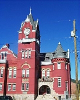
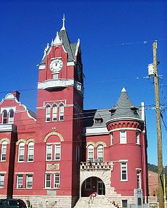
, Tucker County Courthouse and Jail
Tucker County Courthouse and Jail
The Tucker County Courthouse and Jail in Parsons, West Virginia was built in 1898 in a combination of Flemish Renaissance and Romanesque Revival styles. The red pressed-brick structure is flanked by a "jail and jailer's residence" built in 1896 in a similar style.The main courthouse was designed by...
, and Western Maryland Depot
Western Maryland Depot (Parsons, West Virginia)
Western Maryland Depot is a historic railroad depot located at Parsons, Tucker County, West Virginia. It was built by the Western Maryland Railroad in 1888, and is a one-story frame building in the Eastlake Movement / Stick Style. It a simple rectangle measuring 70 feet long and 24 feet wide, with...
.
Geography
Parsons is located at 39°5′45"N 79°40′46"W (39.095721, -79.679465). The Cheat RiverCheat River
The Cheat River is a tributary of the Monongahela River in eastern West Virginia and southwestern Pennsylvania in the United States. Via the Monongahela and Ohio rivers, it is part of the Mississippi River watershed, ultimately draining into the Gulf of Mexico.-Geography:The Cheat is formed at...
is formed at Parsons by the confluence of the Shavers Fork and the Black Fork
Black Fork (Cheat River)
The Black Fork is a principal tributary of the Cheat River in eastern West Virginia in the United States. It is a short stream, about four miles in length,The American Rivers Outstanding Rivers List, Second Edition, May 1991. Compiled and edited by Matthew H. Huntington and John D. Echeverria. ...
.
According to the United States Census Bureau
United States Census Bureau
The United States Census Bureau is the government agency that is responsible for the United States Census. It also gathers other national demographic and economic data...
, the city has a total area of 1.2 square miles (3.1 km²), of which, 1.1 square miles (2.8 km²) of it is land and 0.1 square miles (0.3 km²) of it (9.17%) is water.
Demographics
As of the censusCensus
A census is the procedure of systematically acquiring and recording information about the members of a given population. It is a regularly occurring and official count of a particular population. The term is used mostly in connection with national population and housing censuses; other common...
of 2000, there were 1,463 people, 642 households, and 426 families residing in the city. The population density
Population density
Population density is a measurement of population per unit area or unit volume. It is frequently applied to living organisms, and particularly to humans...
was 1,332.5 people per square mile (513.5/km²). There were 731 housing units at an average density of 665.8 per square mile (256.6/km²). The racial makeup of the city was 98.97% White, 0.21% Native American, 0.07% from other races
Race (United States Census)
Race and ethnicity in the United States Census, as defined by the Federal Office of Management and Budget and the United States Census Bureau, are self-identification data items in which residents choose the race or races with which they most closely identify, and indicate whether or not they are...
, and 0.75% from two or more races. Hispanic or Latino of any race were 0.34% of the population.
There were 642 households out of which 27.4% had children under the age of 18 living with them, 52.5% were married couples
Marriage
Marriage is a social union or legal contract between people that creates kinship. It is an institution in which interpersonal relationships, usually intimate and sexual, are acknowledged in a variety of ways, depending on the culture or subculture in which it is found...
living together, 10.3% had a female householder with no husband present, and 33.5% were non-families. 29.9% of all households were made up of individuals and 14.5% had someone living alone who was 65 years of age or older. The average household size was 2.28 and the average family size was 2.82.
In the city the population was spread out with 22.4% under the age of 18, 6.7% from 18 to 24, 27.8% from 25 to 44, 25.2% from 45 to 64, and 18.0% who were 65 years of age or older. The median age was 40 years. For every 100 females there were 89.5 males. For every 100 females age 18 and over, there were 86.8 males.
The median income for a household in the city was $26,424, and the median income for a family was $31,645. Males had a median income of $22,331 versus $20,069 for females. The per capita income
Per capita income
Per capita income or income per person is a measure of mean income within an economic aggregate, such as a country or city. It is calculated by taking a measure of all sources of income in the aggregate and dividing it by the total population...
for the city was $16,565. About 16.1% of families and 18.7% of the population were below the poverty line, including 22.7% of those under age 18 and 13.0% of those age 65 or over.
Brief History
Parsons was created in the heart of Tucker County, and is named after Ward Parsons, owner of the land the town was founded upon. The railway by passed the town of St. George(which suffered a severe fire in 1888) and when through the heart of the town and connected to present-day Elkins. The railway caused the town to boom by the 1980's.In 1889, 1890 and 1892, Mr. Parsons and his citizens petitioned to have the county seat moved from St. George to Parsons, all attempts failed to gather the necessary 60 majority rule. In 1893, the 60 percent was achieved and Parsons collected it's title as the new county seat. However, prominent citizens of St. George protested the vote, claiming irregularities in the voting. When the court overruled the claim, Adam C. Minear and William M. Cayton took their case to the state government.
Ward and citizens of Parsons eventually got fed up with the government and took it upon themselves to march into the St. George courthouse and steal the courthouse records for their own. Their attempt was successful, and they even stole the bell from their clock tower. Parsons citizens marched back to the town and kept the city records and the bell in a small store until a permanent courthouse was constructed in 1900.