

Great Appalachian Valley
Encyclopedia
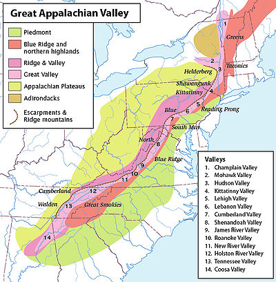
The Great Valley, also called the Great Appalachian Valley or Great Valley Region, is one of the major landform features of eastern North America
. It is a gigantic trough — a chain of valley lowlands — and the central feature of the Appalachian Mountain system. The trough stretches about 1200 miles from Quebec to Alabama and has been an important north-south route of travel since prehistoric times.
physiographic province
. There are many regional names of the Great Valley, such as the Shenandoah Valley. From a large perspective the Great Valley can be divided into a northern section and a southern section.
lowlands encompassing the 106 miles (170.6 km) Richelieu River
(a tributary of the St. Lawrence River) draining the Champlain Valley
, then southerly in succession through the Hudson River Valley
, up the Newburgh Valley and Wallkill Valley
to Port Jervis, New York
crossing into the Delaware River
basin in the Kittatinny valley
(at the Delaware Water Gap
), Lehigh Valley
, Lebanon Valley
, and reaching the Potomac River
watershed and the northern part of the Cumberland Valley
.
A series of mountains bounds the valley to the east, including, from north to south, the Green Mountains
of Vermont
, the Taconic Mountains
, the Reading Prong
(which includes the Hudson Highlands
), the New York and New Jersey Highlands (including the Kittatinny Mountains
), Schunemunk Mountain
, and the Ramapo Mountains
), and South Mountain
of Pennsylvania
. There is a wide gap between Reading Prong and South Mountain, through which the Susquehanna River
passes, connecting the Great Valley with the Piedmont
region of southeast Pennsylvania. Some sources cite this gap as the dividing point between the northern and southern sections of the Great Valley.
Another series of mountains makes up a more impenetrable series of north-south oriented line of ridges and bounds the valley to the west. These are mainly the first major ridges of the Valley and Ridge Appalachians
and the eastern escarpments of the Allegheny Mountains
and Allegheny Plateau
. They include, from north to south, the Adirondack Mountains
; the Catskill Mountains
(specifically the Helderberg Escarpment
); and a long and nearly continuous mountain ridge with several names—Shawangunk Ridge
, Kittatinny Mountains
, Blue Mountain
—stretching from New York through New Jersey to Pennsylvania. This long mountain continues into Virginia with the name North Mountain
. These mountains on the west side of the Great Valley are broken by the gap of the Mohawk Valley
in New York, which connects the Hudson River Valley with the lowlands south of Lake Ontario
. The long Kittatinny-Blue-North Mountain is broken by a few narrow wind and water gap
s, such as Culver Gap, Delaware Water Gap
, Pennsylvania Wind Gap
, Lehigh River
Gap, Schuylkill River
Gap, Swatara
Gap, the Susquehanna River
Gap, Big Gap, and, farther south, the Potomac River
Gap.
, which extend north into Pennsylvania as South Mountain
. Regional names of the southern Great Valley include Hagerstown Valley
in Maryland
, Winchester Valley and Shenandoah Valley
in Virginia
and West Virginia
, the upper valley of the James River
, Roanoke Valley
, and New River Valley
in Virginia, the Holston River
Valley in Virginia and Tennessee
, and the East Tennessee Valley
extending from Virginia through Tennessee to Alabama
. Some sources describe the Coosa River
Valley as the southernmost part of the Great Valley. These southern portions of the Great Valley are sometimes grouped into two parts, the Valley of Virginia and the Tennessee Valley.
The southern Great Valley is bounded on the east by the Blue Ridge physiographic province, which includes, from north to south, South Mountain
in Pennsylvania, the Blue Ridge of Virginia, Holston Mountain
in Tennessee, and the Unaka Range
and the Great Smoky Mountains
of Tennessee and North Carolina. An important gap in these mountains occurs near Roanoke, Virginia
. Other gaps of note in the Blue Ridge of Virginia, connecting the Piedmont region with the Great Valley include Thornton Gap
, Swift Run Gap
, and Rockfish Gap
.
Another series of mountains bounds the southern Great Valley to the west, including North Mountain
and Great North Mountain
, the Allegheny Front
, Powell Mountain, Cumberland Mountains
, Walden Ridge
, and the Cumberland Plateau
. The Cumberland Gap
connects the Great Valley region with Kentucky
and Tennessee lands to the west.
Massanutten Mountain
lies in the middle of the Valley of Virginia portion of the Great Valley.
The Valley of Virginia is a region of karst
, with many sinkhole
s and cavern
s.
. In pre-colonial and early colonial times a major Indian pathway through the Great Valley was known as the Great Indian Warpath
, Seneca Trail, and various other names.
For white immigrants the Great Valley was a major route for settlement and commerce in the United States along the Great Wagon Road
, which began in Philadelphia. In the Shenandoah Valley the road was known as the Valley Pike
. The Wilderness Road
branched off from the Great Wagon Road at present-day Roanoke, Virginia
, crossed the Cumberland Gap
and led to Kentucky and Tennessee, especially the fertile Bluegrass region
and Nashville Basin
. Another branch at Roanoke, called the Carolina Road, led into the Piedmont
regions of North Carolina
, South Carolina
, and Georgia
.
The various gaps connecting the Great Valley to lands to the east and west have played important roles in American history. On the east side, the wide gap in southeast Pennsylvania became the main route for colonization of the Great Valley. By the 1730s the Pennsylvanian Great Valley west of South Mountain was open to settlement after treaty cessions and purchases from the Indians. The region drew a steady and growing stream of immigrants and became known as "the best poor man's country". Before long immigrants had thoroughly settled the Great Valley in Pennsylvania and were rapidly migrating and settling southwards into the Shenandoah Valley of Virginia. The entire region between southeast Pennsylvania and the Shenandoah Valley soon became famous as a "breadbasket", the most productive mixed farming region in America (Meinig, 1986:134). The road from Philadelphia west to the valley and then south through it became very heavily used and known variously as the Great Wagon Road, the Philadelphia Wagon Road, the Valley Road, etc. The Conestoga wagon
was developed around 1725 in the area of the wide opening between Philadelphia and the Great Valley. The Conestoga wagon became the main vehicle for transportation through the Great Valley until the railroad era.
Culver Gap near Culvers Lake in Sussex County, New Jersey, was an important route through the Kittatinny Mountain from about 10,000 years ago to present. The Gap is more than 400 feet below the top of the mountain. Lenape Native Americans used the gap to hunt and trade on both sides of the mountain. Early settlers from Pennsylvania used the water drop from Culvers Lake to Branchville for a wide assortment of mills. Turnpikes followed the route of Lenape trails through the gap.
By the 1750s the Great Valley was well-settled to the southern end of Shenandoah Valley. Immigrants continued to travel from the Philadelphia area south through the Great Valley beyond Shenandoah, to the vicinity of the modern city of Roanoke, Virginia. There is a wide gap in the Blue Ridge near Roanoke. A branch of the Great Wagon Road began there, crossing through the gap east into the Piedmont region of North Carolina and South Carolina. This road became known as the Carolina Road. During the 1750s the stream of migrants traveling south through the valley and into the Carolina Piedmont grew into a flood. At the time, the Carolina Piedmont region offered some of the best land at the lowest prices. Soon a string of towns appeared, including Salisbury
, Salem
, and Charlotte
in North Carolina. In the decades before the American Revolution
the Piedmont "upcountry" of the Carolinas was quickly settled, mostly by recent immigrants who had migrated from the north to the south via the Great Valley. Many of these immigrants were Scots-Irish, Germans from the Rhineland-Palatinate
area, and Moravians
. This "upcountry" population soon surpassed the older and more established "lowcountry" population near the Atlantic coast, causing serious geopolitical tensions in the Carolinas during the late 18th century (Meinig, 1986: 291–293).
On the west side, the Cumberland Gap became the main route for migration west from the southern Great Valley to Kentucky and Tennessee. In the north, the Mohawk Valley
became a major route for westward expansion, especially after the construction of the Erie Canal
, which linked New York City to the Great Lakes
region via the Hudson River of the Great Valley and the Mohawk Valley gap.
The Great Valley played an important role during the American Civil War
, especially the Shenandoah Valley, its Blue Ridge gaps and nearby Piedmont area, and its northward extension to the vicinity of Gettysburg
. Civil War era sites and events in this region include Harpers Ferry
, Antietam
, Manassas, Virginia
, Chambersburg, Pennsylvania
, the Valley Campaign
, the Valley Campaigns of 1864
, the Battles of Chattanooga
, and the Gettysburg Campaign
.
To the north, I-81 continues past Harrisburg, and along with sections of Interstate 476
, serves most of the Pennsylvanian regions in the Appalachian Valley. It eventually connects to Interstate 84
in Scranton. I-84 crosses the Delaware River near Port Jervis and continues to roughly parallel the northern reaches of the Valley, until its mid-Hudson junction at Newburgh with Interstate 87
, a highway which spends the rest of its length closely tracing the Hudson River and Lake Champlain valleys to the north. I-87 becomes Autoroute 15 at the Canadian border and continues to follow the Richelieu River valley north, through southern Quebec
to the Montreal area.
.
North America
North America is a continent wholly within the Northern Hemisphere and almost wholly within the Western Hemisphere. It is also considered a northern subcontinent of the Americas...
. It is a gigantic trough — a chain of valley lowlands — and the central feature of the Appalachian Mountain system. The trough stretches about 1200 miles from Quebec to Alabama and has been an important north-south route of travel since prehistoric times.
Geography
Broadly defined, the Great Valley marks the eastern edge of the Ridge and ValleyRidge-and-valley Appalachians
The Ridge-and-Valley Appalachians, also called the Ridge and Valley Province or the Valley and Ridge Appalachians, are a physiographic province of the larger Appalachian division and are also a belt within the Appalachian Mountains extending from southeastern New York through northwestern New...
physiographic province
United States physiographic region
The list of continental United States Physiographic regions identifies the 8 regions, 25 provinces, and 85 sections. The system dates to Nevin Fenneman's paper Physiographic Subdivision of the United States, published in 1917...
. There are many regional names of the Great Valley, such as the Shenandoah Valley. From a large perspective the Great Valley can be divided into a northern section and a southern section.
Northern section
In its northern section, the Great Valley includes the Lake ChamplainLake Champlain
Lake Champlain is a natural, freshwater lake in North America, located mainly within the borders of the United States but partially situated across the Canada—United States border in the Canadian province of Quebec.The New York portion of the Champlain Valley includes the eastern portions of...
lowlands encompassing the 106 miles (170.6 km) Richelieu River
Richelieu River
The Richelieu River is a river in Quebec, Canada. It flows from the north end of Lake Champlain about north, ending at the confluence with the St. Lawrence River at Sorel-Tracy, Quebec downstream and northeast of Montreal...
(a tributary of the St. Lawrence River) draining the Champlain Valley
Champlain Valley
The Champlain Valley is a region of the United States around Lake Champlain in Vermont and New York extending slightly into Quebec, Canada as part of the St. Lawrence River drainage basin drained northward by the Richelieu River into the St...
, then southerly in succession through the Hudson River Valley
Hudson Valley
The Hudson Valley comprises the valley of the Hudson River and its adjacent communities in New York State, United States, from northern Westchester County northward to the cities of Albany and Troy.-History:...
, up the Newburgh Valley and Wallkill Valley
Wallkill River
The Wallkill River, a tributary of the Hudson, drains Lake Mohawk in Sparta, New Jersey, flowing from there generally northeasterly to Rondout Creek in New York, near Rosendale, with the combined flows reaching the Hudson at Kingston....
to Port Jervis, New York
Port Jervis, New York
Port Jervis is a city on the Delaware River in western Orange County, New York, with a population of 8,860 at the 2000 census. The communities of Deerpark, Huguenot, Sparrowbush, and Greenville are adjacent to Port Jervis, and the towns of Montague, New Jersey and Matamoras, Pennsylvania face the...
crossing into the Delaware River
Delaware River
The Delaware River is a major river on the Atlantic coast of the United States.A Dutch expedition led by Henry Hudson in 1609 first mapped the river. The river was christened the South River in the New Netherland colony that followed, in contrast to the North River, as the Hudson River was then...
basin in the Kittatinny valley
Kittatinny valley
The Kittatinny Valley lies east of the Kittatinny Mountain in western Sussex County, New Jersey. To the east of the valley is the Highlands in eastern Sussex County. The valley is part of the Great Appalachian Valley.-Geography:...
(at the Delaware Water Gap
Delaware Water Gap
The Delaware Water Gap is on the border of New Jersey and Pennsylvania where the Delaware River cuts through a large ridge of the Appalachian Mountains...
), Lehigh Valley
Lehigh Valley
The Lehigh Valley, known officially by the United States Census Bureau as the Allentown-Bethlehem-Easton, PA-NJ metropolitan area and referred to locally as The Valley and A-B-E, is a metropolitan region consisting of Lehigh, Northampton, Berks, and Carbon counties in eastern Pennsylvania and...
, Lebanon Valley
Lebanon, Pennsylvania
Lebanon, formerly known as Steitztown, is a city in and the county seat of Lebanon County, Pennsylvania, United States. The population was 25,477 at the 2010 census, a 4.2% increase from the 2000 count of 24,461...
, and reaching the Potomac River
Potomac River
The Potomac River flows into the Chesapeake Bay, located along the mid-Atlantic coast of the United States. The river is approximately long, with a drainage area of about 14,700 square miles...
watershed and the northern part of the Cumberland Valley
Cumberland Valley
The Cumberland Valley is a constituent valley of the Great Appalachian Valley and a North American agricultural region within the Atlantic Seaboard watershed in Pennsylvania and Maryland....
.
A series of mountains bounds the valley to the east, including, from north to south, the Green Mountains
Green Mountains
The Green Mountains are a mountain range in the U.S. state of Vermont. The range extends approximately .-Peaks:The most notable mountains in the range include:*Mount Mansfield, , the highest point in Vermont*Killington Peak, *Mount Ellen,...
of Vermont
Vermont
Vermont is a state in the New England region of the northeastern United States of America. The state ranks 43rd in land area, , and 45th in total area. Its population according to the 2010 census, 630,337, is the second smallest in the country, larger only than Wyoming. It is the only New England...
, the Taconic Mountains
Taconic Mountains
The Taconic Mountains or Taconic Range are a physiographic section of the larger New England province and part of the Appalachian Mountains, running along the eastern border of New York State and adjacent New England from northwest Connecticut to western Massachusetts, north to central western...
, the Reading Prong
Reading Prong
The Reading Prong is a physiographic subprovince of the New England Uplands section of the New England province of the Appalachian Highlands. The prong consists of mountains made up of crystalline metamorphic rock.-Location:...
(which includes the Hudson Highlands
Hudson Highlands
The Hudson Highlands are mountains on both sides of the Hudson River in the U.S. state of New York, between Newburgh Bay and Haverstraw Bay, which form the northern region of the New York - New Jersey Highlands....
), the New York and New Jersey Highlands (including the Kittatinny Mountains
Kittatinny Mountains
The Kittatinny Mountains are a long ridge traversing across northwestern New Jersey running in a northeast-southwest axis. It is the first major ridge in the far northeastern extension of the Ridge and Valley province of the Appalachian Mountains...
), Schunemunk Mountain
Schunemunk Mountain
Schunemunk Mountain is the highest mountain in Orange County, New York. The 1,664-foot summit is located in the town of Blooming Grove, with other portions in Cornwall and Woodbury. The community of Mountain Lodge Park is built up its western slope.The mountain is a popular recreational resource...
, and the Ramapo Mountains
Ramapo Mountains
The Ramapo Mountains are a forested chain of the Appalachian mountains in northeastern New Jersey and southeastern New York in the United States...
), and South Mountain
South Mountain (Maryland and Pennsylvania)
South Mountain is the northern extension of the Blue Ridge Mountain range in Maryland and Pennsylvania. From the Potomac River near Knoxville, Maryland in the south, to Dillsburg, Pennsylvania in the north, the long range separates the Hagerstown and Cumberland valleys from the Piedmont regions of...
of Pennsylvania
Pennsylvania
The Commonwealth of Pennsylvania is a U.S. state that is located in the Northeastern and Mid-Atlantic regions of the United States. The state borders Delaware and Maryland to the south, West Virginia to the southwest, Ohio to the west, New York and Ontario, Canada, to the north, and New Jersey to...
. There is a wide gap between Reading Prong and South Mountain, through which the Susquehanna River
Susquehanna River
The Susquehanna River is a river located in the northeastern United States. At long, it is the longest river on the American east coast that drains into the Atlantic Ocean, and with its watershed it is the 16th largest river in the United States, and the longest river in the continental United...
passes, connecting the Great Valley with the Piedmont
Piedmont (United States)
The Piedmont is a plateau region located in the eastern United States between the Atlantic Coastal Plain and the main Appalachian Mountains, stretching from New Jersey in the north to central Alabama in the south. The Piedmont province is a physiographic province of the larger Appalachian division...
region of southeast Pennsylvania. Some sources cite this gap as the dividing point between the northern and southern sections of the Great Valley.
Another series of mountains makes up a more impenetrable series of north-south oriented line of ridges and bounds the valley to the west. These are mainly the first major ridges of the Valley and Ridge Appalachians
Appalachian Mountains
The Appalachian Mountains #Whether the stressed vowel is or ,#Whether the "ch" is pronounced as a fricative or an affricate , and#Whether the final vowel is the monophthong or the diphthong .), often called the Appalachians, are a system of mountains in eastern North America. The Appalachians...
and the eastern escarpments of the Allegheny Mountains
Allegheny Mountains
The Allegheny Mountain Range , also spelled Alleghany, Allegany and, informally, the Alleghenies, is part of the vast Appalachian Mountain Range of the eastern United States and Canada...
and Allegheny Plateau
Allegheny Plateau
The Allegheny Plateau is a large dissected plateau area in western and central New York, northern and western Pennsylvania, northern and western West Virginia, and eastern Ohio...
. They include, from north to south, the Adirondack Mountains
Adirondack Mountains
The Adirondack Mountains are a mountain range located in the northeastern part of New York, that runs through Clinton, Essex, Franklin, Fulton, Hamilton, Herkimer, Lewis, Saint Lawrence, Saratoga, Warren, and Washington counties....
; the Catskill Mountains
Catskill Mountains
The Catskill Mountains, an area in New York State northwest of New York City and southwest of Albany, are a mature dissected plateau, an uplifted region that was subsequently eroded into sharp relief. They are an eastward continuation, and the highest representation, of the Allegheny Plateau...
(specifically the Helderberg Escarpment
Helderberg Escarpment
The Helderberg Escarpment is an escarpment in eastern New York, roughly west of the city of Albany....
); and a long and nearly continuous mountain ridge with several names—Shawangunk Ridge
Shawangunk Ridge
The Shawangunk Ridge , also known as the Shawangunk Mountains or The Gunks, is a ridge of bedrock in Ulster County, Sullivan County and Orange County in the state of New York, extending from the northernmost point of New Jersey to the Catskill Mountains.The ridgetop, which widens considerably at...
, Kittatinny Mountains
Kittatinny Mountains
The Kittatinny Mountains are a long ridge traversing across northwestern New Jersey running in a northeast-southwest axis. It is the first major ridge in the far northeastern extension of the Ridge and Valley province of the Appalachian Mountains...
, Blue Mountain
Blue Mountain (Pennsylvania)
Blue Mountain is a ridge that forms the eastern edge of the Appalachian mountain range in the U.S. state of Pennsylvania. It cuts across the eastern half of the state from New Jersey to Maryland, providing a distinct boundary between a number of Pennsylvania's geographical and cultural regions...
—stretching from New York through New Jersey to Pennsylvania. This long mountain continues into Virginia with the name North Mountain
North Mountain (Virginia-West Virginia)
North Mountain is a mountain ridge within the Ridge-and-valley Appalachians in the U.S. states of Virginia and West Virginia.-Geography:North Mountain spans from the Potomac River in the north to the community of Green Spring in Frederick County, Virginia in the south. The ridge is divided into...
. These mountains on the west side of the Great Valley are broken by the gap of the Mohawk Valley
Mohawk Valley
The Mohawk Valley region of the U.S. state of New York is the area surrounding the Mohawk River, sandwiched between the Adirondack Mountains and Catskill Mountains....
in New York, which connects the Hudson River Valley with the lowlands south of Lake Ontario
Lake Ontario
Lake Ontario is one of the five Great Lakes of North America. It is bounded on the north and southwest by the Canadian province of Ontario, and on the south by the American state of New York. Ontario, Canada's most populous province, was named for the lake. In the Wyandot language, ontarío means...
. The long Kittatinny-Blue-North Mountain is broken by a few narrow wind and water gap
Water gap
A water gap is an opening or notch which flowing water has carved through a mountain range. Water gaps often offer a practical route for road and rail transport to cross mountain ridges.- Geology :...
s, such as Culver Gap, Delaware Water Gap
Delaware Water Gap
The Delaware Water Gap is on the border of New Jersey and Pennsylvania where the Delaware River cuts through a large ridge of the Appalachian Mountains...
, Pennsylvania Wind Gap
Wind Gap, Pennsylvania
Wind Gap is a borough in Northampton County, Pennsylvania, United States. Wind Gap is located in the Lehigh Valley region of the state. It is part of Pennsylvania's Slate Belt .The population of Wind Gap was 2,720 at the 2010 census.-Geography:...
, Lehigh River
Lehigh River
The Lehigh River, a tributary of the Delaware River, is a river located in eastern Pennsylvania, in the United States. Part of the Lehigh, along with a number of its tributaries, is designated a Pennsylvania Scenic River by the state's Department of Conservation and Natural Resources...
Gap, Schuylkill River
Schuylkill River
The Schuylkill River is a river in Pennsylvania. It is a designated Pennsylvania Scenic River.The river is about long. Its watershed of about lies entirely within the state of Pennsylvania. The source of its eastern branch is in the Appalachian Mountains at Tuscarora Springs, near Tamaqua in...
Gap, Swatara
Swatara Creek
Swatara Creek is a tributary of the Susquehanna River in east central Pennsylvania in the United States. "Swatara" is an Indian word meaning "Where we feed on eels."...
Gap, the Susquehanna River
Susquehanna River
The Susquehanna River is a river located in the northeastern United States. At long, it is the longest river on the American east coast that drains into the Atlantic Ocean, and with its watershed it is the 16th largest river in the United States, and the longest river in the continental United...
Gap, Big Gap, and, farther south, the Potomac River
Potomac River
The Potomac River flows into the Chesapeake Bay, located along the mid-Atlantic coast of the United States. The river is approximately long, with a drainage area of about 14,700 square miles...
Gap.
Southern section
In its southern section, the Great Valley is bounded to the east by the Blue Ridge MountainsBlue Ridge Mountains
The Blue Ridge Mountains are a physiographic province of the larger Appalachian Mountains range. This province consists of northern and southern physiographic regions, which divide near the Roanoke River gap. The mountain range is located in the eastern United States, starting at its southern-most...
, which extend north into Pennsylvania as South Mountain
South Mountain (Maryland and Pennsylvania)
South Mountain is the northern extension of the Blue Ridge Mountain range in Maryland and Pennsylvania. From the Potomac River near Knoxville, Maryland in the south, to Dillsburg, Pennsylvania in the north, the long range separates the Hagerstown and Cumberland valleys from the Piedmont regions of...
. Regional names of the southern Great Valley include Hagerstown Valley
Hagerstown Valley
Hagerstown Valley is located in Maryland in the United States. It is part of the Great Appalachian Valley, which continues northward as Cumberland Valley in Pennsylvania, and southward as Shenandoah Valley in West Virginia and Virginia....
in Maryland
Maryland
Maryland is a U.S. state located in the Mid Atlantic region of the United States, bordering Virginia, West Virginia, and the District of Columbia to its south and west; Pennsylvania to its north; and Delaware to its east...
, Winchester Valley and Shenandoah Valley
Shenandoah Valley
The Shenandoah Valley is both a geographic valley and cultural region of western Virginia and West Virginia in the United States. The valley is bounded to the east by the Blue Ridge Mountains, to the west by the eastern front of the Ridge-and-Valley Appalachians , to the north by the Potomac River...
in Virginia
Virginia
The Commonwealth of Virginia , is a U.S. state on the Atlantic Coast of the Southern United States. Virginia is nicknamed the "Old Dominion" and sometimes the "Mother of Presidents" after the eight U.S. presidents born there...
and West Virginia
West Virginia
West Virginia is a state in the Appalachian and Southeastern regions of the United States, bordered by Virginia to the southeast, Kentucky to the southwest, Ohio to the northwest, Pennsylvania to the northeast and Maryland to the east...
, the upper valley of the James River
James River (Virginia)
The James River is a river in the U.S. state of Virginia. It is long, extending to if one includes the Jackson River, the longer of its two source tributaries. The James River drains a catchment comprising . The watershed includes about 4% open water and an area with a population of 2.5 million...
, Roanoke Valley
Roanoke Valley
The Roanoke Valley in southwest Virginia is an area adjacent to and including the Roanoke River between the Blue Ridge Mountains to the east and the Appalachian Plateau to the west...
, and New River Valley
New River Valley
The New River Valley is a region in the eastern United States along the New River in the Commonwealth of Virginia . The valley comprises the counties of Montgomery , Pulaski, Floyd, Giles and the independent City of Radford...
in Virginia, the Holston River
Holston River
The Holston River is a major river system of southwestern Virginia and east Tennessee. The three major forks of the Holston rise in southwestern Virginia and have their confluence near Kingsport, Tennessee. The North Fork flows southwest from Sharon Springs in Bland County, Virginia...
Valley in Virginia and Tennessee
Tennessee
Tennessee is a U.S. state located in the Southeastern United States. It has a population of 6,346,105, making it the nation's 17th-largest state by population, and covers , making it the 36th-largest by total land area...
, and the East Tennessee Valley
Tennessee Valley
The Tennessee Valley is the drainage basin of the Tennessee River and is largely within the U.S. state of Tennessee. It stretches from southwest Kentucky to northwest Georgia and from northeast Mississippi to the mountains of Virginia and North Carolina...
extending from Virginia through Tennessee to Alabama
Alabama
Alabama is a state located in the southeastern region of the United States. It is bordered by Tennessee to the north, Georgia to the east, Florida and the Gulf of Mexico to the south, and Mississippi to the west. Alabama ranks 30th in total land area and ranks second in the size of its inland...
. Some sources describe the Coosa River
Coosa River
The Coosa River is a tributary of the Alabama River in the U.S. states of Alabama and Georgia. The river is about long altogether.The Coosa River is one of Alabama's most developed rivers...
Valley as the southernmost part of the Great Valley. These southern portions of the Great Valley are sometimes grouped into two parts, the Valley of Virginia and the Tennessee Valley.
The southern Great Valley is bounded on the east by the Blue Ridge physiographic province, which includes, from north to south, South Mountain
South Mountain (Maryland and Pennsylvania)
South Mountain is the northern extension of the Blue Ridge Mountain range in Maryland and Pennsylvania. From the Potomac River near Knoxville, Maryland in the south, to Dillsburg, Pennsylvania in the north, the long range separates the Hagerstown and Cumberland valleys from the Piedmont regions of...
in Pennsylvania, the Blue Ridge of Virginia, Holston Mountain
Holston Mountain
Holston Mountain is a mountain ridge in Upper East Tennessee and southwest Virginia, in the United States. It is in the Blue Ridge Mountains part of the Appalachian Mountains...
in Tennessee, and the Unaka Range
Unaka Range
The Unaka Range is a mountain range on the border of Tennessee and North Carolina, in the southeastern United States. It is a subrange of the Appalachian Mountains and is part of the Blue Ridge Mountains physiographic province. The Unakas stretch approximately from the Nolichucky River to the...
and the Great Smoky Mountains
Great Smoky Mountains
The Great Smoky Mountains are a mountain range rising along the Tennessee–North Carolina border in the southeastern United States. They are a subrange of the Appalachian Mountains, and form part of the Blue Ridge Physiographic Province. The range is sometimes called the Smoky Mountains or the...
of Tennessee and North Carolina. An important gap in these mountains occurs near Roanoke, Virginia
Roanoke, Virginia
Roanoke is an independent city in the Mid-Atlantic U.S. state of Virginia and is the tenth-largest city in the Commonwealth. It is located in the Roanoke Valley of the Roanoke Region of Virginia. The population within the city limits was 97,032 as of 2010...
. Other gaps of note in the Blue Ridge of Virginia, connecting the Piedmont region with the Great Valley include Thornton Gap
Thornton Gap
Thornton Gap is a wind gap located in the Blue Ridge Mountains in Virginia separating the Shenandoah Valley from the Piedmont region of the state.-History:...
, Swift Run Gap
Swift Run Gap
Swift Run Gap is a wind gap in the Blue Ridge Mountains located in the U.S. state of Virginia.-Geography:At an elevation of , it is the site of the mountain crossing of U.S...
, and Rockfish Gap
Rockfish Gap
Rockfish Gap is a wind gap located in the Blue Ridge Mountains between Charlottesville and Waynesboro, Virginia, United States, through Afton Mountain, which is frequently used to refer to the gap....
.
Another series of mountains bounds the southern Great Valley to the west, including North Mountain
North Mountain (Virginia-West Virginia)
North Mountain is a mountain ridge within the Ridge-and-valley Appalachians in the U.S. states of Virginia and West Virginia.-Geography:North Mountain spans from the Potomac River in the north to the community of Green Spring in Frederick County, Virginia in the south. The ridge is divided into...
and Great North Mountain
Great North Mountain
Great North Mountain is a long mountain range within the Ridge-and-valley Appalachians in the U.S. states of Virginia and West Virginia. The range is located west of the Shenandoah Valley and Massanutten Mountain in Virginia, and east of the Allegheny Mountains and Cacapon River in West...
, the Allegheny Front
Allegheny Front
The Allegheny Front is the major southeast- or east-facing escarpment in the Allegheny Mountains in southern Pennsylvania, western Maryland, and eastern West Virginia, USA. The Allegheny Front delineates the Ridge-and-Valley Appalachians to its east from the Appalachian Plateau to its west...
, Powell Mountain, Cumberland Mountains
Cumberland Mountains
The Cumberland Mountains are a mountain range in the southeastern section of the Appalachian Mountains. They are located in southern West Virginia, western Virginia, eastern edges of Kentucky, and eastern middle Tennessee, including the Crab Orchard Mountains...
, Walden Ridge
Walden Ridge
Walden Ridge is a mountain ridge and escarpment located in Tennessee, in the United States. It marks the eastern edge of the Cumberland Plateau and is generally considered part of it. Walden Ridge is about long, running generally north-south...
, and the Cumberland Plateau
Cumberland Plateau
The Cumberland Plateau is the southern part of the Appalachian Plateau. It includes much of eastern Kentucky and western West Virginia, part of Tennessee, and a small portion of northern Alabama and northwest Georgia . The terms "Allegheny Plateau" and the "Cumberland Plateau" both refer to the...
. The Cumberland Gap
Cumberland Gap
Cumberland Gap is a pass through the Cumberland Mountains region of the Appalachian Mountains, also known as the Cumberland Water Gap, at the juncture of the U.S. states of Tennessee, Kentucky, and Virginia...
connects the Great Valley region with Kentucky
Kentucky
The Commonwealth of Kentucky is a state located in the East Central United States of America. As classified by the United States Census Bureau, Kentucky is a Southern state, more specifically in the East South Central region. Kentucky is one of four U.S. states constituted as a commonwealth...
and Tennessee lands to the west.
Massanutten Mountain
Massanutten Mountain
Massanutten Mountain is a synclinal ridge in the Ridge-and-Valley Appalachians, located in the U.S. state of Virginia.-Geography:The mountain bisects the Shenandoah Valley just east of Strasburg in Shenandoah County in the north, to its highest peak east of Harrisonburg in Rockingham County in the...
lies in the middle of the Valley of Virginia portion of the Great Valley.
The Valley of Virginia is a region of karst
KARST
Kilometer-square Area Radio Synthesis Telescope is a Chinese telescope project to which FAST is a forerunner. KARST is a set of large spherical reflectors on karst landforms, which are bowlshaped limestone sinkholes named after the Kras region in Slovenia and Northern Italy. It will consist of...
, with many sinkhole
Sinkhole
A sinkhole, also known as a sink, shake hole, swallow hole, swallet, doline or cenote, is a natural depression or hole in the Earth's surface caused by karst processes — the chemical dissolution of carbonate rocks or suffosion processes for example in sandstone...
s and cavern
Cave
A cave or cavern is a natural underground space large enough for a human to enter. The term applies to natural cavities some part of which is in total darkness. The word cave also includes smaller spaces like rock shelters, sea caves, and grottos.Speleology is the science of exploration and study...
s.
History
Routes through the valley were first used by Native AmericansNative Americans in the United States
Native Americans in the United States are the indigenous peoples in North America within the boundaries of the present-day continental United States, parts of Alaska, and the island state of Hawaii. They are composed of numerous, distinct tribes, states, and ethnic groups, many of which survive as...
. In pre-colonial and early colonial times a major Indian pathway through the Great Valley was known as the Great Indian Warpath
Great Indian Warpath
The Great Indian Warpath — also known as the Great Indian War and Trading Path, or the Seneca Trail — was that part of the network of trails in eastern North America developed and used by Native Americans which ran through the Great Appalachian Valley...
, Seneca Trail, and various other names.
For white immigrants the Great Valley was a major route for settlement and commerce in the United States along the Great Wagon Road
Great Wagon Road
The Great Wagon Road was a colonial American improved trail transiting the Great Appalachian Valley from Pennsylvania to North Carolina, and from there to Georgia....
, which began in Philadelphia. In the Shenandoah Valley the road was known as the Valley Pike
Valley Pike
Valley Pike or Valley Turnpike is the traditional name given for the Indian trail and roadway which now is designated as U.S. Highway 11 in the Shenandoah Valley of Virginia....
. The Wilderness Road
Wilderness Road
The Wilderness Road was the principal route used by settlers for more than fifty years to reach Kentucky from the East. In 1775, Daniel Boone blazed a trail for the Transylvania Company from Fort Chiswell in Virginia through the Cumberland Gap into central Kentucky. It was later lengthened,...
branched off from the Great Wagon Road at present-day Roanoke, Virginia
Roanoke, Virginia
Roanoke is an independent city in the Mid-Atlantic U.S. state of Virginia and is the tenth-largest city in the Commonwealth. It is located in the Roanoke Valley of the Roanoke Region of Virginia. The population within the city limits was 97,032 as of 2010...
, crossed the Cumberland Gap
Cumberland Gap
Cumberland Gap is a pass through the Cumberland Mountains region of the Appalachian Mountains, also known as the Cumberland Water Gap, at the juncture of the U.S. states of Tennessee, Kentucky, and Virginia...
and led to Kentucky and Tennessee, especially the fertile Bluegrass region
Bluegrass region
The Bluegrass Region is a geographic region in the state of Kentucky, United States. It occupies the northern part of the state and since European settlement has contained a majority of the state's population and its largest cities....
and Nashville Basin
Nashville Basin
The Nashville Basin, also known as the Central Basin, is a term often used to describe the area surrounding Nashville, Tennessee. The Central Basin was caused by an uplifting known as the Nashville Dome. The Nashville Dome is evidenced by the underlying rock strata that all dip downwards away from...
. Another branch at Roanoke, called the Carolina Road, led into the Piedmont
Piedmont (United States)
The Piedmont is a plateau region located in the eastern United States between the Atlantic Coastal Plain and the main Appalachian Mountains, stretching from New Jersey in the north to central Alabama in the south. The Piedmont province is a physiographic province of the larger Appalachian division...
regions of North Carolina
North Carolina
North Carolina is a state located in the southeastern United States. The state borders South Carolina and Georgia to the south, Tennessee to the west and Virginia to the north. North Carolina contains 100 counties. Its capital is Raleigh, and its largest city is Charlotte...
, South Carolina
South Carolina
South Carolina is a state in the Deep South of the United States that borders Georgia to the south, North Carolina to the north, and the Atlantic Ocean to the east. Originally part of the Province of Carolina, the Province of South Carolina was one of the 13 colonies that declared independence...
, and Georgia
Georgia (U.S. state)
Georgia is a state located in the southeastern United States. It was established in 1732, the last of the original Thirteen Colonies. The state is named after King George II of Great Britain. Georgia was the fourth state to ratify the United States Constitution, on January 2, 1788...
.
The various gaps connecting the Great Valley to lands to the east and west have played important roles in American history. On the east side, the wide gap in southeast Pennsylvania became the main route for colonization of the Great Valley. By the 1730s the Pennsylvanian Great Valley west of South Mountain was open to settlement after treaty cessions and purchases from the Indians. The region drew a steady and growing stream of immigrants and became known as "the best poor man's country". Before long immigrants had thoroughly settled the Great Valley in Pennsylvania and were rapidly migrating and settling southwards into the Shenandoah Valley of Virginia. The entire region between southeast Pennsylvania and the Shenandoah Valley soon became famous as a "breadbasket", the most productive mixed farming region in America (Meinig, 1986:134). The road from Philadelphia west to the valley and then south through it became very heavily used and known variously as the Great Wagon Road, the Philadelphia Wagon Road, the Valley Road, etc. The Conestoga wagon
Conestoga wagon
The Conestoga wagon is a heavy, broad-wheeled covered wagon that was used extensively during the late 18th century and the 19th century in the United States and sometimes in Canada as well. It was large enough to transport loads up to 8 tons , and was drawn by horses, mules or oxen...
was developed around 1725 in the area of the wide opening between Philadelphia and the Great Valley. The Conestoga wagon became the main vehicle for transportation through the Great Valley until the railroad era.
Culver Gap near Culvers Lake in Sussex County, New Jersey, was an important route through the Kittatinny Mountain from about 10,000 years ago to present. The Gap is more than 400 feet below the top of the mountain. Lenape Native Americans used the gap to hunt and trade on both sides of the mountain. Early settlers from Pennsylvania used the water drop from Culvers Lake to Branchville for a wide assortment of mills. Turnpikes followed the route of Lenape trails through the gap.
By the 1750s the Great Valley was well-settled to the southern end of Shenandoah Valley. Immigrants continued to travel from the Philadelphia area south through the Great Valley beyond Shenandoah, to the vicinity of the modern city of Roanoke, Virginia. There is a wide gap in the Blue Ridge near Roanoke. A branch of the Great Wagon Road began there, crossing through the gap east into the Piedmont region of North Carolina and South Carolina. This road became known as the Carolina Road. During the 1750s the stream of migrants traveling south through the valley and into the Carolina Piedmont grew into a flood. At the time, the Carolina Piedmont region offered some of the best land at the lowest prices. Soon a string of towns appeared, including Salisbury
Salisbury, North Carolina
Salisbury is a city in Rowan County in North Carolina, a state of the United States of America. The population was 33,663 in the 2010 Census . It is the county seat of Rowan County...
, Salem
Winston-Salem, North Carolina
Winston-Salem is a city in the U.S. state of North Carolina, with a 2010 population of 229,617. Winston-Salem is the county seat and largest city of Forsyth County and the fourth-largest city in the state. Winston-Salem is the second largest municipality in the Piedmont Triad region and is home to...
, and Charlotte
Charlotte, North Carolina
Charlotte is the largest city in the U.S. state of North Carolina and the seat of Mecklenburg County. In 2010, Charlotte's population according to the US Census Bureau was 731,424, making it the 17th largest city in the United States based on population. The Charlotte metropolitan area had a 2009...
in North Carolina. In the decades before the American Revolution
American Revolution
The American Revolution was the political upheaval during the last half of the 18th century in which thirteen colonies in North America joined together to break free from the British Empire, combining to become the United States of America...
the Piedmont "upcountry" of the Carolinas was quickly settled, mostly by recent immigrants who had migrated from the north to the south via the Great Valley. Many of these immigrants were Scots-Irish, Germans from the Rhineland-Palatinate
Rhineland-Palatinate
Rhineland-Palatinate is one of the 16 states of the Federal Republic of Germany. It has an area of and about four million inhabitants. The capital is Mainz. English speakers also commonly refer to the state by its German name, Rheinland-Pfalz ....
area, and Moravians
Moravians (ethnic group)
Moravians are the modern West Slavic inhabitants of the historical land of Moravia, the easternmost part of the Czech Republic, which includes the Moravian Slovakia. They speak the two main groups of Moravian dialects , the transitional Bohemian-Moravian dialect subgroup and standard Czech...
. This "upcountry" population soon surpassed the older and more established "lowcountry" population near the Atlantic coast, causing serious geopolitical tensions in the Carolinas during the late 18th century (Meinig, 1986: 291–293).
On the west side, the Cumberland Gap became the main route for migration west from the southern Great Valley to Kentucky and Tennessee. In the north, the Mohawk Valley
Mohawk Valley
The Mohawk Valley region of the U.S. state of New York is the area surrounding the Mohawk River, sandwiched between the Adirondack Mountains and Catskill Mountains....
became a major route for westward expansion, especially after the construction of the Erie Canal
Erie Canal
The Erie Canal is a waterway in New York that runs about from Albany, New York, on the Hudson River to Buffalo, New York, at Lake Erie, completing a navigable water route from the Atlantic Ocean to the Great Lakes. The canal contains 36 locks and encompasses a total elevation differential of...
, which linked New York City to the Great Lakes
Great Lakes
The Great Lakes are a collection of freshwater lakes located in northeastern North America, on the Canada – United States border. Consisting of Lakes Superior, Michigan, Huron, Erie, and Ontario, they form the largest group of freshwater lakes on Earth by total surface, coming in second by volume...
region via the Hudson River of the Great Valley and the Mohawk Valley gap.
The Great Valley played an important role during the American Civil War
American Civil War
The American Civil War was a civil war fought in the United States of America. In response to the election of Abraham Lincoln as President of the United States, 11 southern slave states declared their secession from the United States and formed the Confederate States of America ; the other 25...
, especially the Shenandoah Valley, its Blue Ridge gaps and nearby Piedmont area, and its northward extension to the vicinity of Gettysburg
Battle of Gettysburg
The Battle of Gettysburg , was fought July 1–3, 1863, in and around the town of Gettysburg, Pennsylvania. The battle with the largest number of casualties in the American Civil War, it is often described as the war's turning point. Union Maj. Gen. George Gordon Meade's Army of the Potomac...
. Civil War era sites and events in this region include Harpers Ferry
Harpers Ferry, West Virginia
Harpers Ferry is a historic town in Jefferson County, West Virginia, United States. In many books the town is called "Harper's Ferry" with an apostrophe....
, Antietam
Battle of Antietam
The Battle of Antietam , fought on September 17, 1862, near Sharpsburg, Maryland, and Antietam Creek, as part of the Maryland Campaign, was the first major battle in the American Civil War to take place on Northern soil. It was the bloodiest single-day battle in American history, with about 23,000...
, Manassas, Virginia
Manassas, Virginia
The City of Manassas is an independent city surrounded by Prince William County and the independent city of Manassas Park in the Commonwealth of Virginia in the United States. Its population was 37,821 as of 2010. Manassas also surrounds the county seat for Prince William County but that county...
, Chambersburg, Pennsylvania
Chambersburg, Pennsylvania
Chambersburg is a borough in the South Central region of Pennsylvania, United States. It is miles north of Maryland and the Mason-Dixon line and southwest of Harrisburg in the Cumberland Valley, which is part of the Great Appalachian Valley. Chambersburg is the county seat of Franklin County...
, the Valley Campaign
Valley Campaign
Jackson's Valley Campaign was Confederate Maj. Gen. Thomas J. "Stonewall" Jackson's famous spring 1862 campaign through the Shenandoah Valley in Virginia during the American Civil War...
, the Valley Campaigns of 1864
Valley Campaigns of 1864
The Valley Campaigns of 1864 were American Civil War operations and battles that took place in the Shenandoah Valley of Virginia from May to October 1864. Military historians divide this period into three separate campaigns, but it is useful to consider the three together and how they...
, the Battles of Chattanooga
Battle of Chattanooga
There were three Battles of Chattanooga fought in or near Chattanooga, Tennessee, during the American Civil War:* First Battle of Chattanooga, minor artillery bombardment by Union Brigadier General James S. Negley against Confederate Maj. Gen...
, and the Gettysburg Campaign
Gettysburg Campaign
The Gettysburg Campaign was a series of battles fought in June and July 1863, during the American Civil War. After his victory in the Battle of Chancellorsville, Confederate General Robert E. Lee's Army of Northern Virginia moved north for offensive operations in Maryland and Pennsylvania. The...
.
Interstate Highways
Today, the main thoroughfares occupying the southern Great Valley are:- Interstate 81Interstate 81Interstate 81 is an Interstate Highway in the eastern part of the United States. Its southern terminus is at Interstate 40 in Dandridge, Tennessee; its northern terminus is on Wellesley Island at the Canadian border, where the Thousand Islands Bridge connects it to Highway 401, the main freeway...
from Harrisburg, PennsylvaniaHarrisburg, PennsylvaniaHarrisburg is the capital of Pennsylvania. As of the 2010 census, the city had a population of 49,528, making it the ninth largest city in Pennsylvania...
to the road's southern terminus near Dandridge, TennesseeDandridge, TennesseeDandridge is a town in Jefferson County, Tennessee, United States. It is the county seat of Jefferson County. It is part of the Morristown, Tennessee Metropolitan Statistical Area.... - Interstate 40Interstate 40Interstate 40 is the third-longest major east–west Interstate Highway in the United States, after I-90 and I-80. Its western end is at Interstate 15 in Barstow, California; its eastern end is at a concurrency of U.S. Route 117 and North Carolina Highway 132 in Wilmington, North Carolina...
from the I-81 interchange to KnoxvilleKnoxville, TennesseeFounded in 1786, Knoxville is the third-largest city in the U.S. state of Tennessee, U.S.A., behind Memphis and Nashville, and is the county seat of Knox County. It is the largest city in East Tennessee, and the second-largest city in the Appalachia region... - Interstate 75Interstate 75Interstate 75 is a major north–south Interstate Highway in the Great Lakes and Southeastern regions of the United States. It travels from State Road 826 and State Road 924 in Hialeah, Florida to Sault Ste. Marie, Michigan, at the Ontario, Canada, border...
from Knoxville to ClevelandCleveland, TennesseeCleveland is a city in Bradley County, Tennessee, United States. The population was 41,285 at the 2010 census. It is the county seat of Bradley County...
To the north, I-81 continues past Harrisburg, and along with sections of Interstate 476
Interstate 476
Interstate 476 is a auxiliary Interstate Highway in the U.S. state of Pennsylvania designated between Interstate 95 near Chester and Interstate 81 near Scranton, serving as the primary north–south Interstate corridor through eastern Pennsylvania....
, serves most of the Pennsylvanian regions in the Appalachian Valley. It eventually connects to Interstate 84
Interstate 84 (east)
Interstate 84 is an Interstate Highway extending from Dunmore, Pennsylvania at an interchange with Interstate 81 to Sturbridge, Massachusetts, at an interchange with the Massachusetts Turnpike . I-84 has mile-log junction numbering in Pennsylvania; otherwise, exit numbers are roughly sequential...
in Scranton. I-84 crosses the Delaware River near Port Jervis and continues to roughly parallel the northern reaches of the Valley, until its mid-Hudson junction at Newburgh with Interstate 87
Interstate 87
Interstate 87 is a Interstate Highway located entirely within New York State in the United States of America. I-87 is the longest intrastate Interstate highway in the Interstate Highway System. Its southern end is at the Bronx approaches of the Robert F. Kennedy Bridge in New York City...
, a highway which spends the rest of its length closely tracing the Hudson River and Lake Champlain valleys to the north. I-87 becomes Autoroute 15 at the Canadian border and continues to follow the Richelieu River valley north, through southern Quebec
Quebec
Quebec or is a province in east-central Canada. It is the only Canadian province with a predominantly French-speaking population and the only one whose sole official language is French at the provincial level....
to the Montreal area.
Culture
The Great Valley, especially the southern-middle portion, is the core of the region known as AppalachiaAppalachia
Appalachia is a term used to describe a cultural region in the eastern United States that stretches from the Southern Tier of New York state to northern Alabama, Mississippi, and Georgia. While the Appalachian Mountains stretch from Belle Isle in Canada to Cheaha Mountain in the U.S...
.